Letters, Points of Interest, Week in Review (Announcements, Contracts, Products, Events, Training and Education) Back Issues, Advertise, Contact, Subscribe/Unsubscribe If, for some reason you cannot read this document, visit: http://www.gismonitor.com/news/newsletter/archive/123003.php
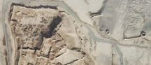
USGS Imagery of Capitol Area "Blurred" SecurityFocus reported on December 18 that certain aerial images available via MapQuest showed blurred, distorted images of areas including the White House and neighboring Old Executive Office Building and Treasury Department. "The Capitol building and the grounds of the Naval Observatory, where the Vice President's residence is located, have been distorted -- pixilated into an digital blur," according to the article which cites the government secrecy watchdog site Cryptome as its source.
The article goes on to note that the distortion was done by EarthData, which took the images under contract to the U.S. Geological Survey, as part of the National Aerial Photography Program. The distortions were added at the request of the Secret Service, according to a USGS spokesperson. Older images, writer Kevin Poulsen notes, showing the same areas without distortion, are available on the Web and in print. That led Stephen Aftergood, director of the Project on Government Secrecy at the Federation of American Scientists, to note that "except in the case of unacknowledged government facilities, it is hard to see what is gained by this policy, and the downside, I think, is that it encourages public paranoia."
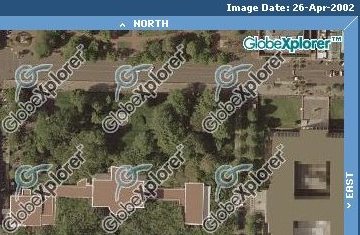
I did my own searching and found that MapQuest no longer hosts aerial imagery on its website. Apparently, its agreement with GlobeXplorer to have an "Aerial Photo" tab on MapQuest-hosted maps has ended. Over at the GlobeXplorer website, I found obscured images. But at TerraServer USA (Microsoft Research's website) I found some nice old (April 5, 1998) USGS images. First We've Heard of It According to an Associated Press (AP) article on December 24, 2003, GlobeXplorer, which buys the imagery from the United States Geological Survey (USGS), was not aware of the changes until it was contacted by the news service. A representative from that company was quoted as saying, "This is the first time we've seen anything like this. We'd prefer that it not be there." The company is considering replacing the altered imagery with commercial replacements that have not been altered. Interestingly, the image associated with the CBS News version of the AP story is a fuzzy profile view of the White House. The story is titled, "The Feds Want Fuzz." A version at USA Today includes an aerial image from USGS, as does one from CNN. How Did This Happen? EarthData agreed to degrade the images in exchange for permission to capture data over Washington, D.C. in April 2002. Flights over Washington have been restricted since 9/11. With guidance from the Secret Service the company blocked out some parts of images and blurred others. Responses Discussions at SecurityFocus generally agreed that manipulating current imagery, despite older data that is widely available, is akin to trying to "stuff the genie back into the bottle." Several posters to the discussion board noted that anyone walking by the areas obscured in the images can acquire detailed information. One other post sounded like a request for metadata about the changes to the imagery. "Strategic places may of course be protected against any unlikely unforeseen hazard, however, with pictures, this simple fact should be mentioned or given some specific public consideration. Just like with the mentioning of copyright. Very easy. Simply balance both interests against each other, and there is a perfectly acceptable solution." The AP article notes that the USGS has been distributing the distorted imagery since December 2002 without formally acknowledging the alterations. The images, the article notes, were part of a project to gather high resolution images of key U.S. cities. Ironically, an NGA [new name for NIMA] representative once claimed that program, sometimes called the "133 Cities Program," did not exist. A USGS representative says no other images from that effort, about half of which are completed, have been altered. Special thanks to Gary Napier at Space Imaging for help researching this story.

Bringing Mapping Services to the Masses An article this past week in the Boston Globe (sorry, online archives require payment) focused on the work of Brian Smith of Tele Atlas. The article went on to note that competitor Navigation Technologies is the market leader. The article included the results of a test of three services: MapQuest, Yahoo Maps, and MapPoint. Each service developed a route, from start of Paul Revere's famous ride here in and around Boston to its finish. In part, this route was meant to highlight the mess the Big Dig (our long-term highway project) has been for mapmakers. MapQuest received the lowest marks since it suggested a prohibited turn. Yahoo Maps avoided the messy, oft-changing, Interstate 93 area and provided the shortest route. MapPoint "won" with a slightly longer route, but the shortest time. It did, in fact, provide a valid route through the Big Dig. This article does a fine job of defining what constitutes a consumer Web mapping service. Such a service provides the answer to a question, in this case, "what's the best way to get from here to there?" Those who dig a bit deeper, or those who build such systems, realize the answer is based on two basic parts: data and a routing algorithm. We as GIS professionals in time, will hopefully be able to pick and choose which data and which algorithm to use for such a solution. But for consumers, it's all mixed into one.

"In the Dec. 30th issue you referenced David Pogue's Circuits newsletter and his naughty & nice comments. #2 was 'Nice: He honors Circuit City and its no-hassle return policy. You don't even need your receipt. Why? It's in the computer. Wouldn't it be nice to call GIS tech support and not need your customer ID? Perhaps we are already there? Readers?' "Unfortunately just this morning I had a return call from my customer service rep. at ESRI. I had called him and left a message on 12/18 and when he didn't call back by 12/29 I left another message. He called on 12/30 and 'in general' answered my questions. Then he said, 'if you could give me your customer number I could answer specifically.' Since he was returning my call he certainly knew who I was. Couldn't he have that information at his fingertips? Shame on him.'" Reid notes that ESRI's users contact a different customer service department than do ESRI partners like ADCi. � Sonny Parafina wrote about last week's article on Bentley's new "extreme mapping" promotion. "I believe that this article by Maddox adequately represents my opinion on Extreme Mapping. Here is a relevant excerpt: "'Little by little, advertisers are moving towards the 'X-TREME' marketing school of thought (or lack of thought, as the case may be). Everything from Jello to health bars are being plastered with the 'X-TREME' eye sore. [�] "Bentley has really gone off the deep end. We are highly trained professionals, not a testosterone crazed 13-25 year-old male demographic. "[�] I get the sense that because they [Bentley] do produce a very good CAD product they think can also be savvy marketers. I call this 'the professional's syndrome,' i.e. any professional can do any job just as well or better than the professional that performs that job. This is particularly endemic or epidemic in engineering cultures."

Points of Interest Good Deed Department. Terry Harmon and Reinhold Friebertshauser founded and lead the Chagrin Watershed Institute, a "high school-environmental think tank" devoted to the study of the Chagrin River, its tributaries, wetlands, and, most prominently, the endangered native brook trout. The watershed is in the Cleveland area. Friebertshauser joined the faculty in 1985 to teach mechanical drawing and woodworking but lately has championed the use of GIS. In 2002, the institute created a 50-page atlas of the area. Says Friebertshauser, "We take them out of McDonald's and produce some useful projects for the community." GPS to Enforce "No Fly" Zones? University of California Berkeley engineers and Honeywell workers are testing a GPS system programmed with U.S. "no fly zones." If the plane approaches such a zone, the pilot/hijacker is warned. If it actually crosses into one, "auto-pilot" technology takes over. GPS "faking" and the fact that "auto-pilot" cannot be over-ridden are two strikes against such technology, in my mind. Mudslide Maps Were Available. Maps predicting mudslides in the hills above San Bernardino, California, where at least 13 people were killed in recent weeks, were available (free registration required) and evacuations had been considered. The maps, made by the USGS with help from ESRI, showed potential areas for mudslides, though some argue the maps were not widely publicized. Moving to Just a Cell Phone. A recent survey suggests that about 18% of cell phone subscribers use the device as their primary phone. That means, should they need emergency assistance, there's a good chance, if they can't speak, authorities will have a hard time finding them. The same is true of Internet phone systems according to an article in the Mercury News. (Companies like Quova might disagree to a point.) One idea is to embed GPS in the hardware used to make "voice over IP" calls. One problem: such hardware would likely be indoors, where GPS signals are iffy. A Second Robot Navigation Race. After DARPA changed the "open to all" rules for its robot race across the California desert, the uninvited formed the International Robot Racing Federation (IRRF). That group will host its own truly open-to-all, race in September 2004 in Clark County, Nevada. The winner, just as in the DARPA race, will take home $1 million. One sponsor of the IRRF is from the geospatial arena: Manifold.net, based in Carson City, Nevada. Distance to Cancer Treatment Linked to Survival. A report in the September 17 Journal of the National Cancer Institute, and covered in The University of Chicago Magazine, documents that cancer patients who travel more than 15 miles for treatment have one-third the risk of dying than those treated closer to home. As the distance of treatment increases 10 miles, the risk of death decreases by 3.2%. The study controlled for a variety of factors and the lead investigator feels the study confirms something long suspected: that patients who seek different therapeutic options "fare better than those who end up at the closest place." Canadian Theme Maps. Ever wonder how they make those silly maps that pinpoint place names of certain themes? Well, the woman behind the Canadian ones (themes include: bugs, meat, beer, and some "adult" ones) uses the federal government Geographical Names website. Published in conjunction with the magazine Geist, the maps are a bit of Canadiana and says one Canadian studies professor in Germany, "the maps were just about the only thing that could get my students excited." I do have a favorite: the Stan Rogers Map highlights the places the late folk singer included in his songs. "How I wish I was in Sherbrooke now!" Judges Dismisses Town Appeal to Hold GIS Data. Greenwich, Connecticut lost a second time in its efforts to keep its imagery from a citizen who wants to package and resell it. State Superior Court Judge Howard Owens Jr. dismissed the town's appeal of a November 2002 state Freedom of Information Commission ruling. The judge had ordered the town to turn over the data. In its argument against such a release, the town cited privacy and security issues. Judge Owens cited "a lack of concrete evidence to support the town's claim that materials' release presented an immediate danger to the community."

� Announcements Tim Berners-Lee, acknowledged as the inventor of the Web, has been awarded a knighthood for his work. Haestad Methods, in its 25th year in business, announced double-digit gains in 2003. The company did not disclose which double digit number was reached. A completed study suggests that integrating land mapping, marine charts, and geological information around Britain's coastline would save money and help both the public and private sector. The challenge now: funding such an effort. ORBIMAGE Inc. announced this week that it officially emerged from bankruptcy protection effective December 31, 2003. The GPS market will be worth more than $22 billion by 2008, according to technology market research firm ABI. GITA announced its new board of Directors headed by GITA President Stewart Asbury. President of the SpatialAge Solutions Division, Byers Engineering Company, Atlanta, Georgia. Asbury has served as chair of both GITA's Annual Conference and Education committees. J. Peter Gomez, manager of information requirements for Xcel Energy's Asset Management organization, Denver, Colorado, will serve as the association's president-elect for the year. At-large members include Peter Batty, chief technology officer, Ten Sails, Greenwood Village, Colorado; Brent Jones, vice president of Energy and Telecommunications Services for James W. Sewall Company, Old Town, Maine; and Xavier Lopez, director of Spatial, Location and Network Technologies for Oracle Corp., Nashua, NewHampshire among others. Missoula County, Montana, with support from GCS Research, has become the first county in the state, and one of the first in the nation, to publish its geospatial data to The National Map. Cambridge, Mass-based MetaCarta, Inc. announced that it had secured $6.5 million in Series B funding from venture capital firms and institutional investors.

� Contracts and Sales UndS�kC, Swedish Armed Forces Intelligence and Security Centre has equipped the Anubis system with RaveGeo from Idevio. The Anubis system compiles intelligence information and aims to predict the enemy's movement. RaveGeo is a compression and streaming technology for digital maps. The County of Essex (Canada's southernmost county) including the lower tier municipalities has selected ESRI Canada to implement a complete asset management solution. The U.S. Air Force, on Monday, said it awarded Boeing Co. and Lockheed Martin Corp., each $20.8 million in new contracts to continue work on the next generation of the Global Positioning System. MapQuest Mobile service, powered by Vindigo, MovieGoer film guide, powered by Vindigo, and NYTimes.com Mobile News, powered by Vindigo are now available on a subscription basis on select PCS Vision mobile phones. So, the online, PDA services are now full phone services. Could that be all the LBS one needs? Avineon, Inc. announced that Upper Peninsula Power Company (UPPCO) and Wisconsin Public Service Corporation (WPSC) selected the team of Field Data Services, Inc. (FDSI) and Avineon, Inc. to implement a geographic information system (GIS) for UPPCO. The project began in September 2003. Accela, Inc. announced that Fort Myers, Florida has selected the company to implement a new enterprise land information system. � Products Spatial Business Systems Inc. announced a solution for integrating the Smallworld Core Spatial Technology from GE Network Solutions with Safe Software's Feature Manipulation Engine (FME). The solution allows full control of Smallworld data translation via the FME Universal Translator, FME Workbench, and the FME Universal Viewer, opening the Smallworld Core Spatial Technology to the enterprise and more than 100 spatial data formats. Pharos Science & Applications Inc. partnered with Hitachi, Ltd. to enable Hitachi's new G1000 Multimedia Communicator with Windows Mobile software for Pocket PCs with Pharos' Ostia Smart Navigator, a service to combine GPS navigation, real-time traffic, and dynamic points-of-interest look-up. � Events GITA has announced the dates and topics for this year's webcast series. Topics include Web services, interoperability, and mobile technologies. ESRI is now accepting abstract submissions for paper presentations for the ESRI Education User Conference (EdUC). The deadline is January 16, 2004. Congressman Adam Putnam will present the keynote address at the 4th Annual ESRI Federal User Conference on January 20, 2004, at the Washington Convention Center in Washington, D.C. I'll be among those attending. � Training and Education The Ordnance Survey now provides students and citizens with the ability to electronically select and overlay boundaries ranging from local council wards to region-wide constituencies of the European Parliament. With the support of a three-year $432,000 grant from the National Science Foundation (NSF), Professor Richard LeGates and Assistant Professor Ayse Pamuk, both in the urban studies department at San Francisco State University, will take their approach to teaching research methods and data analysis to social science students at a national level. A key component: GIS. The pair is developing instructional modules to introduce GIS and data graphics to social science undergraduates worldwide via the Web.
Advertise With Us
Contact GIS Monitor is published by: GITC America, Inc.
Subscribe/Unsubscribe |