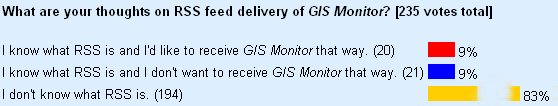
Letters, Points of Interest, Week in Review (Announcements, Contracts, Products, Events, Training and Education, Hires) Back Issues, Advertise, Contact, Subscribe/Unsubscribe If, for some reason you cannot read this document, visit: http://www.gismonitor.com/news/newsletter/archive/012204.php
Editor's Note
At least one respondent was frustrated that I'd not provided an explanation of RSS. I apologize for being a bit coy on this, but I really wanted to know if readers had even heard of the technique. This week's issue covers RSS in detail. But before diving into RSS, here's GIS Monitor's plan on the matter. We'll continue to explore what readers want and what makes sense. At least right now, there's not a lot of demand, and I for one am not yet convinced RSS is the next big thing. Adena

RSS was originally developed by Netscape. And, as one of the poll respondents noted, there is more than one format for RSS. You can read the history here. Here's how it works. If I want to share some of the content of GIS Monitor with readers via RSS, I create an RSS document and host it on the website. This is Slashdot's document, for example. It is XML and if you look carefully, you'll see regular old URLs and titles of articles. A reader would then subscribe to the feed with an RSS aware software program, often an RSS aggregator. Here's a list of some aggregators. Typically you need to download and install software, but here's a Web-based aggregator that'll do the same thing, without a download. (It's sort of the "Hotmail" version of RSS.) The feed itself is typically a series of short items - something like my Points of Interest that includes some text and a link for more information. Several respondents to the poll suggested the Points of Interest blurbs might be the right type of content to distribute this way. Many online magazines and blogs (Web logs, online diaries of a sort) provide RSS feeds including Wired and Slashdot. Wired did a nice, non-technical piece about RSS in August of last year. And, for a very short, to the point "how to" see this article. The reasons people use RSS aware software vs. just going to the website or subscribing to newsletters include: - RSS aware software regularly checks (e.g., each hour) to see "what's new" on these websites and downloads the new bits to the client software. - One piece of software can "keep an eye" on many different websites at the same time - Information is pulled down to your desktop, that is, you request it, versus e-mail where others push the messages (and other things!) to you. - No e-mail address needs to be shared with unknown parties. - Users can turn off the feed (unsubscribe) at any time. Why would a content publisher want to use an RSS feed? - It allows other websites to include, automatically, a link to content from a provider's website, without introducing another copy. (Consider for a moment how many times that press release from ESRI is reprinted on the Web.) - It allows more access points to original content since more websites and RSS readers know about the new content on the original provider's website.
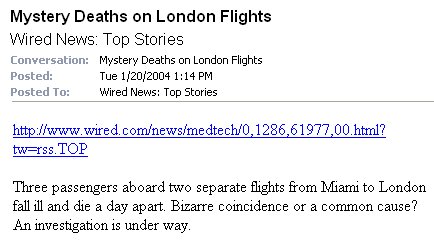
So, how do I feel about it? I've known about RSS for about a year, but I never actually installed RSS aware software until this week. I downloaded a trial version of NewsGator, an aggregator that runs inside of Outlook, and subscribed to a few websites I regularly read. How is it? Well, it depends. I don't find the very minimalist feeds (above), sometimes called "lite" RSS feeds, very useful. For example, the title and URL of a story on Slashdot is just not enough for me. I find I actually prefer to go to the homepage and browse all the single paragraph blurbs. "So, why not send those?" one might ask Slashdot. I'll guess at an answer: it doesn't help the website stay in business. Eyeballs visiting the website make advertisers happy and keep the ads coming. There is some debate on how advertising will fare on RSS. Another service that provides minimalist headlines of press releases was also not that appealing, though I confess it was easier to skip over these. The most useful feeds for me were those that gave a decent sized blurb, or less commonly, the full text on the topic, sometimes called "full" RSS feeds. Wired provides blurbs, for example (below). That gave me enough information to know that I should look further, or delete the item. But since on average I read at least one full article per day at Wired, there's really no benefit for me in RSS. I might as well visit the magazine's news page.
Many websites don't provide RSS feeds yet. But, there are tools to "fake" feeds from websites that do not provide them. I read one blogger's note that explained he couldn't find GIS feeds, so created his own using such a tool.

Following Up on Some Promised Products First up: The new version of MapInfo, the .NET version. I wrote about it at length in 2002 noting a potential ship date of 2003. And, I reported last August that the release of the desktop version was slated for fall 2004. So, how's it coming? The MapInfo .NET software development kit (SDK) is now in beta for both the desktop and the Web. Those with a MapInfo SitePass can download either version, play with it, provide feedback, and participate in discussion areas. Second up: ESRI's Interoperability Kits for ArcGIS. These are add-ons to allow the product to act as a client to OpenGIS Web Map Service and Web Feature Service Specification-based map servers and support Geography Markup Language (GML) (I consult to the Open GIS Consortium.) There have been many availability dates provided in print and by ESRI reps (see for example here, in ArcNews). The ESRI discussion areas on the topic are full of international users from Italy, Denmark, Australia, and the UK along with ESRI staff postings from some of those counties, asking when they will be available. The latest post from ESRI said the products would be available the end of the week of January 6th. The download was posted on January 21. (I'll hazard a guess there was a goal of announcing availability at the ESRI Federal User Group Meeting this week.) Third up: Oracle's latest version Oracle 10g, with its enhanced Locator (in the box) and Oracle Spatial add-on. When I discussed the launch I noted my confusion about when the product was due out. A reader explained that the Application Server would ship first (it did on December 10), and the database later. An Oracle rep explained the Oracle 10g database will be available "very soon." It was expected in the December/January timeframe according to one source, so it's "on time" by some measure. By the way, there are many new documents on Oracle Spatial and Locator updated or created for the new release, available now.

Hottest LBS Story to Date? I recall a conversation I had with a geographer friend of mine just a few years ago about location-based services (LBS). He made it quite clear that LBS wouldn't take off until the privacy issues were nailed down. And, based on the coverage of an announcement by Bell Labs to tackle that exact challenge, he may be correct. I don't think I've seen an announcement in this part of the market get as much digital coverage as Bell Labs' press release and an Associated Press article describing its new software (officially "Privacy-Conscious Personalization (PCP) framework") for personal management of "findability." Company researchers are presenting a paper on the topic this week at the 2004 IEEE International Conference on Mobile Data Management in Berkeley, California. A quick look on Tuesday showed 97 news outlets had picked up the AP story. Here's a version from the Raleigh News. The press release, with far more detail, was harder to find. The Idea I've always felt that simply being able to turn tracking "on and off" was enough control for an LBS device, presuming that permission had to be provided to anyone who wanted the information in the first place. I use that logic with my cell phone. If I don't want to receive calls I turn it off. I know that sounds silly, but I've run into far too many people who use the "I don't want to be bothered" excuse as the reason not to have a cell phone. When I suggest that turning off the phone prevents being bothered, I get a surly look. What Bell Labs is offering is basically something between "on" and "off" for tracking. The Bell Labs solution addresses the "conflicting demands of speed, privacy, and personalization on a live telephone network." Apparently, it's quite complicated to update complex personal preferences on a live network, without, among other things, dragging the whole system to a crawl. While some users might be ok with a simple "on/off," others will demand more options. The wireless carriers, Bell Labs hopes, will want one engine to manage both ends of the consumer spectrum. Rick Hull, director of Network Data and Services Research at Bell Labs describes that some users might want family members to have detailed information on their location, while friends or colleagues get more generalized info ("within 15 miles") and others are shut out all together. Currently, LBS users have only a few options, according to the Bell Labs press release. They can make location information available to everyone, to a defined group, or only to authorized officials in emergency situations. How it Works The press release hints that this is a "smart" device, one that "relies on user preferences to intelligently infer context such as working or shopping, and then determines with whom location information should be shared." In practice, when a request comes in for a user's location it's sent through a series of filters based on consumer preferences, and the system determines if the information should be given, and if so, how "scrambled" it might be. To me that rings of SPAM filters and selective availability (which to be fair, wouldn't be a bad name for such a system). But, unlike e-mail, a system in which users can stand some level of time delay (filters and rules are commonplace now and slow down mail sending and receiving), a real-time cell network needs a quicker turn around. Bell Labs offers just that, running the filters in milliseconds. Bell Labs imagines offering some "most common" rules or even palettes for different types of users (student, salesperson, stay-at-home mom for example) to jump start setting up their custom preferences. The privacy advocates are strong marketers for Bell Labs. Says one, the system allows users to take advantage of tracking "without having to buy into a wholesale surveillance mechanism." Commercial deployment is perhaps a year away, but Bell Labs has already negotiated with carriers for trials. My Take There are few interesting concepts hidden in this announcement. One is that it layers one LBS on another LBS. What do I mean? Some of the examples provided about when location information is available can be based on, you guessed it, location. So, for example, if I'm in Madison, Wisconsin, I don't want anyone to know since I'll be on vacation. But, when I'm up in The Dells, it's ok, since I'll be working. So, it seems Bell Labs, or its client, will always have to know where you are. A second thought is that those attempting the tracking might be able to decipher some of the rules and perhaps, use them to guess at the trackee's location. For example, should someone set up such "geofences" (when I cross this line turn tracking information delivery off for this set of people) if nothing else, those trying to track the person might suspect that the person has indeed left some defined area. On the other hand, there may be a series of other reasons that tracking was "turned off" and the tracking request was denied. I presume that tracker would not be privy to the reason the tracking request was refused. Finally, the general name for this "changing preferences" is context awareness. That is, the Bell Labs engine will "know" about the user's context. I read (and I believe wrote) about a similar idea a few months ago. Bell Labs is using the underlying rules engine, called Houdini, in a current commercial product called Vortex, "the policy management part" of a communications gateway. Houdini is also being used to demonstrate context-aware call forwarding and call blocking. Is this a key step in LBS becoming a reality here in the United States? While Bell Lab's technology is certainly interesting and likely useful, my feeling is that there are still many other hurdles ahead of the privacy issue keeping LBS from bursting onto the market. Said another way, if Bell Labs product were already available, I don't think LBS would be in wider use today.

Letters "I happened to be listening to NPR's Fresh Air yesterday and the interview was with journalist Peter Maass. He mentioned that the U.S. forces cannot accurately locate the 'bad guys' even when identified because most of the streets are not named and houses are not numbered. The informants are reluctant to ride along and identify the house. Compounding the trouble is the fact that normal citizens were denied maps and aerial photos for so long that they do not have even the concept of maps." � A relatively new reader has a question for me and more seasoned readers and GIS users. "If I am, to put it politely, underinformed about GIS, then what can be done to raise general awareness of the value of this tool? What can be done to get Joe [average] aware of, if not interested in GIS?" Readers? � On my off-topic discussion of the Boston Herald "selling" its front page, comes this from Melissa Barger of the Opera of Philadelphia. "Hey - historical context!!! In the nineteenth and early twentieth centuries, every newspaper front page included paid advertisements. They were generally below the fold, usually towards the bottom of the page. I believe the practice was generally dropped in the Depression era. This is not new. That Caldor banner is incredibly subtle compared to the advertising that was on front pages of the past."

Points of Interest SpeedPass Moves to Watches. Timex has joined with ExxonMobile to provide the SpeedPass watch. It's a regular watch with an RFID chip that enables you to buy gas at Exxon and Mobile, many Chicago area McDonald's locations, and some Boston supermarkets. I guess you take partners where you can get them, but I'd have tried to get say, Chicago area grocery stores before Boston ones... The watches offered are perhaps slightly more expensive than the regular, non SpeedPass versions. Text Messages Alert of Crash. Researchers funded by the European Commission are testing a technology that would alert emergency personnel when cars are involved in accidents. That sounds fairly easy, but in Europe it means determining which country the vehicle is in to send a text message, not only to the correct authority, but also in the correct language. The device includes a speaker and a microphone so that passengers able to speak can communicate with authorities. The sensor that starts the device is the same one used to activate the airbags.
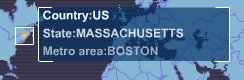
More on Geotargeting. Way back when I launched GIS Monitor I profiled a company called Quova. It was one of the first companies working on geotargeting, the technique of determining the physical location of a Web surfer's wired computer. At that time I asked the company why it didn't have a demo that could provide the geographic location of visitors to its website. I really don't recall the answer. But, this week I received an e-mail from IP2Location.com a product of Hexa Software Development Center, an R&D; company based in Penang, Malaysia. The company claims to be one of the top three companies doing geotargeting and offers an array of server products and Web services that locate wired computers. And, the company offers the demo I always wanted: it told me where it thought I was. It did get my ISP correct, but, alas, placed me in Falmouth, Massachusetts on Cape Cod, about 80 miles from my office. On a wireless network in DC, I was placed in the United States. A Canadian reader reports that he was placed in Alberta, while in British Columbia. Another geotargeting company, InfoSplit, put me in Boston when indeed I was just outside the city (warning - annoying musical/flash intro). Great Use of Mapping in Advertising. Just in case you missed it, there was a great AIDS awareness ad (pdf) used for World AIDS Day (last December 1) that makes great use of mapping. The idea is that the entry in the legend for "regions affected by HIV" and the one for "regions where HIV is preventable" are identical and the symbology covers the entire world. This makes a very powerful statement. Too Many Images from World War II. Reader Martin shares a link to this article in The Guardian. An image taken at 11am on August 23, 1944, that reveals what Auschwitz concentration camp looked like from the air, is being made available (high traffic has kept the website down for much of this week, so far as I could tell) for the first time. While the image is said to be "moving" what's also interesting is that the photographers taking the photos didn't see the significance of what they were shooting. One explanation is that they were so focused on getting as many images as possible without the time to inspect them. I've heard this statement from those working in imagery today, too. Does Geography Matter on the Radio? Gary LaPierre has been on WBZ radio here in Boston for about 40 years. This week it was learned that despite commiserating with New Englanders about the frigid temperatures, he was in fact, broadcasting from Florida, something he'd been doing for 6-8 weeks each year for a few years. Some argue that this is just the same as conglomerates packing up the same program for stations all over the county, but others feel that if people think you are in Boston, you better be in Boston. Windows Longhorn Pushes GIS. Reader Nick pointed out that a multimedia demo of the upcoming Windows platform called Longhorn includes quite a lot of GIS. The premise: integrating a number of people and software packages to find and buy the right piece of property for a stand-alone drug store. RE3W, a startup, is trying to link all the players in a real estate transaction. The idea is that Longhorn allows the integration. Here's what was cool: An e-mail attachment includes a document that's also a full client application. This is basically a GIS app from RE3W. The real estate agent searches the area of interest using the client and MapPoint .Net (Web service) to find a corner location. Then she brings in third party demographics and traffic data to find high volume areas and high growth areas. The application map provides vector graphics and has a "roamer" (a moving magnifying glass that enlarges just the area underneath). Next she adds Keyhole tools to look at a 3D flyover. The Keyhole app is loaded on demand. After looking at the imagery, she orders and buys an updated image of the area from AirViews (an imagery company with which I'm not familiar). That image then comes in superimposed, correctly, on the satellite imagery. They then add, in this 3D view, the parcel information. It's a rather large download, but it's pretty cool.
Real 3D Trees for GIS. What if instead of the single species, somewhat "cartoony" trees used in visualization scenarios, those working in 3D in CAD or GIS, could use models of what look like real trees. There would be different species, different ages, and no two would be identical. Enter Bionatics' REALnat (think real natural). The program allows virtual foresters to grow trees from seeds, controlling for age, weather conditions, and time of year. The "old" way of creating 3D trees involves taking digital pictures, editing those, creating a texture, overlaying the texture on a polygon model, etc. One GIS user explains he can make about 2 trees a day the "old way." With REALnat, he reports, that's enough time to build a forest. First clients are the high end simulator market - especially the military - but civilian uses are coming, too.
� Announcements KEMA, an independent provider of technical and management consulting services to the electric power and gas energy industries, announced the formation of VELOCITIE Integration Inc. VELOCITIE is a GIS software design and development consulting firm focused on geospatial utility operations. Earth Satellite has begun delivery of a global mosaic of Landsat imagery to ESRI. The mosaic is natural colored and is derived from EarthSat's global Landsat mapping product Geocover-Ortho undertaken for NASA. ESRI will deliver this global Landsat 150-meter resolution mosaic with the ArcGIS 9.0 release. The General Services Administration (GSA) has added PCI Geomatics to its list of products and services approved for "GSA Advantage!" purchasing, the U.S. Federal Government's online shopping site. ESRI announced that it provided a leadership role as principal editor of the OpenGIS Location Services (OpenLS) specification, which was key to the approval of the public release of OpenLS Version 1.0 by members of the Open GIS Consortium (OGC) Friday, January 16, 2004. The specification is available here. ESRI joined a group of international corporations supporting the United Nations Environment Programme World Conservation Monitoring Centre's (UNEP-WCMC) Proteus Project. Wellington City Council, New Zealand, was recently honored with the prestigious BearingPoint Award for its CityVIEW system, which uses ESRI technology as a key component. RMSI and their consortium partners Landmark Government and Infoterra have, with the National Assembly for Wales Agriculture and Rural Affairs Department (ARAD), won two awards recognizing the WISARD (Wales Information System for Agricultural and Rural Data) project. The group won both the AGI Central Government Award 2003 for "Outstanding Achievement in the Field of Geographic Information" and the Information Management 2003 Award for the "Most innovative and successful project using geographic information systems." Ubisense, provider of location-aware products built on its sense-driven computing platform has chosen C-MAC MicroTechnology, a Solectron company, to manufacture its leading Local Positioning System (LPS) product. � Contracts and Sales Sanborn won a large image-based GIS project in central California. Sanborn is working for The Association of Monterey Bay Area Governments (AMBAG). Woolpert LLP was recently selected by the Air Force Materiel Command (AFMC), located at Wright-Patterson Air Force Base, Ohio, to provide onsite personnel to support GeoBase implementation at five of its installations. Trimble was awarded two contracts from the U.S. Air Force (USAF) to provide Global Positioning System (GPS) surveying and mapping systems. The GPS equipment will be used as part of the GeoBase Civil Engineering Program for worldwide surveying and construction projects. The contracts are valued at approximately $5 million. JCMB Technology Inc., a provider of software and services for the electric, gas and water utilities, has been awarded a US $1.8 million contract from Northeast Utilities System Co (Berlin, CT). � Products TatukGIS has released the TatukGIS free Viewer 1.0, which is available for anyone to download. Enghouse Systems Limited released NetWORKS 3.3, the seventh major release of the NetWORKS product portfolio which is certified by Enghouse for ArcGIS 8.3. Group 1 Software added SUSE Linux to its list of supported operating systems and platforms. The company makes data quality and direct marketing software. @Road released @Road FieldServices, a suite of 18 new reports specifically designed to help field service organizations uncover operations inefficiencies and measure actual productivity against expected goals. Initially developed for telecommunications customers, @Road FieldServices is designed to provide customers with a new set of metrics to help them maximize field worker productivity prior to starting jobs, between jobs, and at the end of the day when returning to the terminal or yard. � Events The Web-Enabled GIS Strategies 2004 conference is scheduled for Sydney, Australia on March 23rd & 24th, 2004. The Tenth Annual CalGIS Conference (CalGIS 2004) is coming on February 18 through 20 to the San Jos� McEnery Convention Center. Speakers are from ESRI (Dangermond), Intergraph (Holmes), MapInfo (Moon), and Autodesk (Bradshaw). The 2004 Pennsylvania GIS Conference will be held on May 11-12 at the Hilton Harrisburg and Towers and the Whitaker Center for Science and the Arts in Harrisburg, PA. This year's conference theme is "Building Our Spatial Future" and will feature keynote speakers Jack Dangermond, President and Founder of GIS giant ESRI, and James Knudson, Director of GIS for the Commonwealth of Pennsylvania. � Training and Education Solving Disaster Management Problems Using ArcGIS, a new course from ESRI Virtual Campus, is designed for public sector and risk management professionals and others interested in applying geographic information system (GIS) technology to disaster management activities. Loma Linda University's School of Public Health recently developed a certificate program in health geoinformatics. � Hires Hans Hess, CEO of Leica Geosystems, announced the appointment of Bob Williams as president of the company's Surveying and Engineering Division for the Americas selling region.
Advertise With Us
Contact GIS Monitor is published by: GITC America, Inc.
Subscribe/Unsubscribe |