|
2005 May 26
Contents
|
This issue sponsored by: ESRI

|
Departments:
News Briefs, Back Issues, Advertise, Contact, Subscribe/Unsubscribe
If, for some reason, you cannot read this document, visit: http://www.gismonitor.com/news/newsletter/archive/052605.php

Editor's Introduction
In this week's issue of GIS Monitor I report on Microsoft's new Virtual Earth service, which I had a chance to preview. I also briefly note an article on the origins of GIS and do the usual round-up of the news from press releases.
I want to repeat and emphasize what I wrote two weeks ago: please write to me whenever your actual experience with a product or vendor differs substantially from what that vendor told me and I reported.
— Matteo
Microsoft Launches MSN Virtual Earth
Imagine building your own custom 3D digital model of a city in which you want to shop or do business, that you wish to visit, or through which you want to guide someone else. You can layer in streets, oblique views, and aerial photography or satellite imagery — just as with a GIS. You can search for bookstores, Thai restaurants, hardware stores, or wireless Internet hotspots — just as with a search engine�s �local search� function — and mark their locations on the map. Then, you can e-mail someone a URL that will take him or her straight to this custom map you�ve created or you can publish it on your website or blog.
Your data will never be out of date because it will be continuously corrected though feedback from users — pointing out, for example, that a business has moved, that a street is temporarily or permanently blocked, or that the signal in a hotspot is particularly strong. These inputs will be filtered and weighed by the reliability of the users submitting them, on the basis of their peer review score — a point system similar to that used on eBay. Oh, and speaking of your fellow users, they will be in the millions and will be able to use this system to find each other through proximity searches and post their comments and reviews.
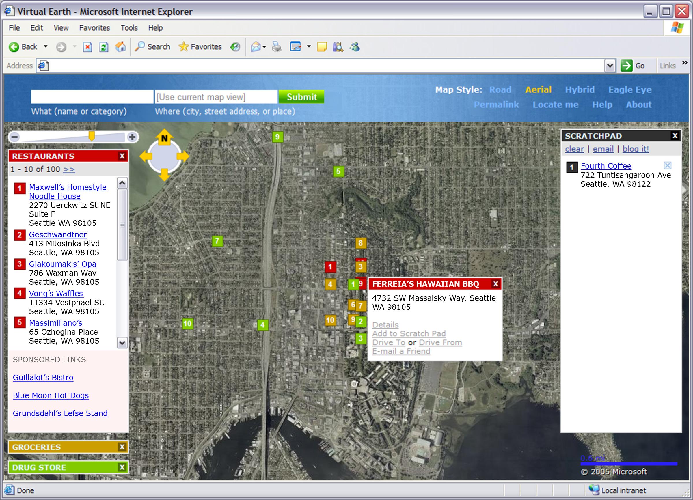
Satellite imagery and multiple search results
This is the vision that Microsoft is proposing with its new MSN Virtual Earth, which I had a chance to preview this week. From his office at the Microsoft campus in Redmond, Washington, Mark Law, the project�s lead product manager within the MapPoint business unit, gave me an on line tour of what he described as �the best of mapping, community, and networking.� He was �driving� the demonstration — moving to different parts of the map, typing in queries, selecting layers, etc. — while I occasionally had to scroll vertically or sideways to make sure that my screen covered the same map extent as his.
Law pointed out emphatically that he was showing me �live code,� not a finished, canned product (�we�ve been coding since January,� he told me). The site will not be launched until �sometime this summer� (other sources say �sometime between June 21 and September 22�). I asked Law why Microsoft was showing me this work in progress. He told me that it was because Bill Gates — who first read a paper on this concept by the MapPoint business unit a couple of months ago, during his bi-annual �Think Week� — liked the project so much that he highlighted it on Monday morning in his presentation at D3, a conference on digital technology sponsored by The Wall Street Journal. Clearly, Gates� eagerness to promote MSN Virtual Earth is due to as much to his awareness of the competition as to his fertile technological imagination. As a successor to the Keyhole desktop software it recently purchased, Google is about to launch Google Earth, which will reportedly feature high-resolution imagery, three-dimensional buildings in some cities, and driving directions.

I immediately noticed that the map of Seattle that Law was showing me �bled� beyond the edges of the screen. He told me that it is an intentional �look� for the product, to make the user feel in the middle of this virtual city — just as if he or she were in the middle of the real one. As he searched successively for pizza parlors, Italian restaurants, and Chinese restaurants, the listings � provided by Amicai, a company that compiles business listings — appeared in numbered lists in successive �scratch pad� boxes and numbers marked their locations on the map, color-coded by restaurant type. Unlike other search engines, which display only the answer to one query at a time, Law pointed out, MSN Virtual Earth will display multiple sets of listings at once, �because when you walk down a real street you don�t just see one kind of restaurant.� Also unlike other search engines, the service will display only the businesses that are located within the map�s extent visible to the user at that moment.
Next, Law overlaid satellite imagery from Terra Server, a database of USGS satellite images that Microsoft has had for about ten years. (The company recently merged the TerraServer and MapPoint business units.) After zooming in, he added street names and 45 degree views of buildings, provided by Pictometry International of Rochester, which also provides aerial photography for MSN Virtual Earth. Law then moved around the map and, as he did, each set of listings updated, to reflect the restaurants within a certain range of his new location. You can use this, he said, to �move around and discover different neighborhoods or towns.� In another example, he entered several addresses in a text box and each generated a marker on the map. You could use this to map the locations of the members of a car pool, he suggested, then e-mail a link to the map to all of the club�s members.
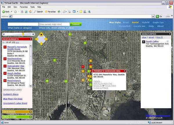
Hybrid: satellite imagery and street map layer
As Law pointed out, for this service Microsoft has updated the navigation bar it uses in MapPoint and implemented new anti-aliasing in the text, so that street names are more legible as you zoom in and out. The interface also includes a feature to speed up movement around the map. It consists of a circle with arrows pointing out at twelve, three, six, and nine o�clock; you place your cursor in the middle of the circle, then move it slightly in a given direction and the map quickly scrolls in that direction.
When he was finished preparing his map, Law showed me how, with a few clicks of his mouse, he could create a URL that would take one right to it — complete with his chosen layers, scratch pads, and location markers. Users will also be able to use the MSN Virtual Earth interface to post images to their MSN Spaces weblog.

Microsoft, according to Law, will implement and upgrade this service in rapidly succeeding waves. It will start in the next couple of weeks by adding a local search index to its MSN website for finding business directory listings. Google, Yahoo, Ask Jeeves, America Online, and other search engines already have local searching capability. It is becoming increasingly popular with users — because it lets them find business listings and complementary information for a specific geographical area — and with advertisers � because it allows them to target their ads only at those who are looking for services and products in their vicinity. Google also provides maps by NAVTEQ / TeleAtlas and satellite images by Digital Globe�s Earth-Sat.
Next, Microsoft will launch MSN Virtual Earth, as a free service, supported by advertisers. Law declined to give me the details on the service�s business model, but assured me that the listings returned by a search query will not be determined by advertising.
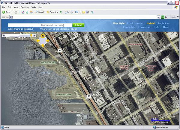
Street map with multiple search results
In the fall Microsoft will release version 2 of MSN Virtual Earth. It will include the oblique views from Pictometry, with which it has signed an exclusive five-year deal. This, according to Law, is an indication of Microsoft�s long-term commitment to this project. His company, he told me, �will work closely with Pictometry to accelerate the capture of U.S. urban centers. Then we will move overseas.� Version 2 will also allow consumers to submit content, as I described above.
Future releases will appear �every 90 days,� Law told me, and include additional layers, such as local weather and traffic maps, and additional components, such as road styles and new navigation features.
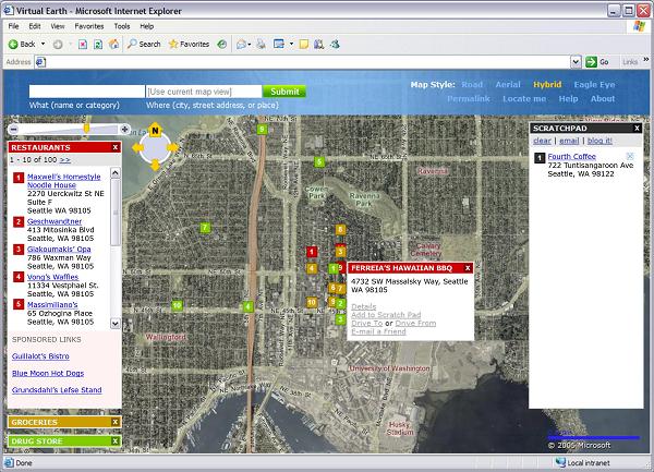
Satellite imagery and street map with multiple search results

45 degree aerial view
Briefly Noted
The June issue of Technology Review includes the article �Do Maps Have Morals?� by Daniel Charles. The subtitle is �Digital mapping is an invaluable tool for business and government — but it�s partly rooted in Cold War schemes for mutual annihilation.� The article includes an interview with historian John Cloud, who challenges the standard history of GIS as rooted in the work of academic scientists. According to Cloud, in Charles� words, �[t]he real roots of digital mapping � reach back to the Cold War and to the U.S. Defense Department�s secret campaign to assemble accurate maps of nuclear targets in the Soviet Union.� According to Charles, �[b]efore taking his current job as a historian for the National Oceanic and Atmospheric Administration, Cloud spent more than a decade assembling an alternative genealogy of GIS, showing military planners, not idealistic landscape architects, to be its fathers.� Cloud and Lawrence Ayers, former deputy director of the U.S. Defense Mapping Agency, Charles writes, �agree the Defense Department laid the foundations for what�s now called GIS. It created the earliest digital maps, and its contracts �pumped money,� as Ayers puts it, into several companies that now play leading roles in the GIS industry.�
Charles also presents the other side of the argument: �Some historians and GIS pioneers, however, dismiss this version of GIS history with a mixture of irritation and disdain. Nicholas Chrisman, from Laval University in Quebec City, says the Pentagon produced little, apart from the Global Positioning System, that the commercial world ever found useful. And none of the early developers of GIS software even knew about the physical overlay maps of the New Deal or the Nazi era [both described by Charles earlier in the article], he says, while they certainly did know about [Ian] McHarg�s [a landscape architect and environmentalist]. ESRI�s [Jack] Dangermond, for his part, says his company knew little about the military�s work and profited even less from it.�
If you have any interest in these debates, I highly recommend that you read the full article.

News Briefs
Please note: I have culled the following news
items from press releases and have not independently verified
them.
PRODUCTS
ESRI has released the latest version of its BusinessMAP 4 database mapping solution, which transforms information from databases, contact managers, and spreadsheets into color maps for improving business presentations and decisions.
BusinessMAP 4 enhancements include ring study analysis, to analyze and reveal the demographics of an area surrounding a location; drive-time analysis, to create up to three drive zones around a location that are defined by the time it takes to drive to or from a given location; print preview, to visualize how maps will print, including various legend options and sizes; new wizards, to color code or customize maps; Canadian maps and data; shaded relief data; ODBC database support; and free 30-day aerial photo subscription, using one-meter orthophotos.
Sylvan Ascent Inc. recently launched TopoPhone, a GPS topographic mapping software for mobile phones. The product turns a cell phone with a built-in GPS receiver into a topographic mapping device by automatically downloading USGS topographic maps. It gives the ability to locate others who are also carrying such phones, using SMS text messaging to send GPS coordinates between phones and displaying their locations on the map.
TopoPhone also provides all the usual GPS capabilities, such as waypoints, trips, and routes. Maps are stored for later use, so TopoPhone can be used even when out of cellular range.
Earlier this month, Microsoft announced the Windows Mobile 5.0 operating system for Smartphones and Pocket PC phones, with GPS functionality built-in. TopoPhone leverages the power of Windows Mobile 5.0 and of the Microsoft .NET Compact Framework 2.0.
MapText, Inc. has released Label-Web 1.0, a text placement engine that labels Web-based maps on the fly in a GeoMedia WebMap 5.2 environment.
Interactive maps are quickly gaining popularity and fast dynamic label placement is critical for Web-mapping applications. To improve user experience, Web maps need to be re-labeled quickly each time the user pans or zooms, and, at the same time, need to provide aesthetic and informative cartographic output. MapText developed Label-Web for Intergraph's GeoMedia WebMap to achieve this goal.
Label-Web places text in accordance with cartographic rules and conventions, avoids text-to-text and text-to-feature overlap (unless expressly allowed), and ensures unambiguous text-to-feature association. It also achieves aesthetic label placement so as to enhance rapid visual comprehension, while maintaining high performance suitable for interactive display over the Internet.
Label-Web can be easily integrated into a server-side script by adding a few lines of code to include the Label-Web application and initiate the text placement.
Hemisphere GPS, a designer and manufacturer of GPS products wholly owned by CSI Wireless Inc., has introduced its own application-specific integrated circuit (ASIC) chipset technology. The Hemisphere ASIC will play a key role in a receiver product line that the company is launching under its new Crescent brand name.
Crescent receivers will be able to simultaneously employ multiple front ends � enabling tighter coupling of measurements from separate antennae for use with heading-based products. Users will obtain improved accuracy and stability, due to Crescent's more accurate code phase measurements, multipath mitigation improvements, and fewer discrete receiver components.
The first Crescent receiver to employ the Hemisphere ASIC is the new Crescent OEM module � an integrated circuit board receiver. It will also enhance Hemisphere's house-brand product lines � Outback, Satloc, and CSI � and be available to OEMs and integrators for use in their product lines.
Crescent technology is the front-end component in a variety of innovations that the company is developing for such applications as agricultural guidance and machine control, marine navigation, and GIS and mapping. The technology can achieve update rates of as much as 20 Hz � making it well suited for these applications.
AmberCore Software, a provider of spatial decision support systems, has released Amber iQ 2.0, a GIS that integrates vector and raster data to produce visual outputs and analysis. The product allows users to integrate advanced spatial analysis functionality � such as Interpolation, Viewshed Analysis, Spatial Correlation, and Predictive Analysis � into their workflow and to create and visualize raster files with no size limits. Amber iQ 2.0 is designed to allow users to view and manipulate 2D & 3D raster / vector outputs in real time and without screen re-fresh. Multiple streams of analysis can be run simultaneously with no interruptions as the program is multi-threaded; and users can leverage the extremely fast, mapping engine to automate tasks.
GeoMicro, a provider of mapping software, has released AltaMap Traffic, a programmable Web service hosted by the company and used by enterprises and independent software developers to integrate real time traffic information into their applications. The service is integrated with the AltaMap Location Based Service Platform, allowing users to combine traffic, routing, location search, and data from GPS receivers. The service currently powers several mobile applications, including MapQuest Traffic and TrafficMap.
Autodesk, Inc. and HP have announced the availability of instant printing capabilities for HP Designjet series printers with Autodesk DWF Viewer, a free, downloadable viewer for 2D and 3D design workflows, and DWF Composer software that enables users to review, mark up and revise drawings.
HP Instant Printing for Autodesk applications offers extended project teams printing of large-format, highly detailed drawings, plans and maps from a software application. For a limited time, Autodesk and HP are offering a free copy of DWF Composer software to customers in the United States who purchase an HP Designjet series printer that includes the new instant print capabilities.
Nokia has introduced the 770 Internet Tablet, a dedicated device optimized for Internet browsing and email communications in a pocketsize format. The device features a high-resolution (800x480) wide-screen display with zoom and on-screen keyboard, designed for viewing online content over Wi-Fi. The device can also connect to the Internet utilizing Bluetooth wireless technology via a compatible mobile phone.
The device runs on Linux-based Nokia Internet Tablet 2005 software edition, which includes widely deployed desktop Linux and other Open Source technologies. The maemo development platform will provide Open Source developers and innovation houses with the tools and opportunities to collaborate with Nokia on future devices and OS releases in the Internet Tablet category.
The Nokia 770 Internet Tablet is planned to start shipping in the third quarter of 2005 in selected countries in the Americas and Europe.
ESRI has released ArcGIS 9.1, a full release of ArcGIS Desktop (ArcReader, ArcView, ArcEditor, and ArcInfo), ArcGIS Engine, ArcGIS Server, ArcIMS, and ArcSDE. In addition, it is the main vehicle for the release of Network Analyst on the ArcGIS platform.
Key features of ArcGIS 9.1 include: improved stability and performance; improved geoprocessing through 63 new tools for ArcView, 86 new tools for ArcEditor, and 22 new tools for ArcInfo; a new merge tool for combining data; the ability to pan to selection and pause drawing; a Save As tool allowing users to save a copy of documents (.mxd, .sxd, .lyr) as in version 8.3 with no changes required in 8.3 projects; better Open Geospatial Consortium, Inc. (OGC) support; and access to 150-meter worldwide natural view imagery and nationwide street data.
ArcGIS Network Analyst is a new extension to the ArcGIS platform that provides network-based spatial analysis including routing, travel directions, closest facility, and service area analysis in addition to multimodal network support. The Network Analyst functionality is available for ArcGIS Desktop, ArcGIS Engine, and ArcGIS Server.
With the release of ArcGIS 9.1, ESRI is announcing changes in the licensing of some existing extensions. Specifically, StreetMap for ArcGIS is included with the ArcGIS Desktop products, ArcGIS Engine, and ArcGIS Server. ArcPress for ArcGIS is included with the ArcGIS Desktop products, ArcScan for ArcGIS is included with ArcEditor and ArcInfo, and Maplex for ArcGIS is included with ArcInfo. In addition, ArcGIS Data Interoperability and ArcGIS Schematics are integrated as optional ArcGIS Desktop extensions, and 3D globe documents as well as 2D maps can be published using ArcGIS Publisher and read using ArcReader.
Developers who have subscribed to the ESRI Developer Network (EDN) will receive an update of ArcGIS 9.1 products, which include ArcGIS Engine Developer Kit, ArcGIS Server, ArcIMS, ArcSDE, and ArcWeb Services. EDN is a developer-centric annual subscription program that provides software developers with the resources needed to build solutions that embed ESRI's desktop and server technologies. All ArcGIS Desktop users who are current on their maintenance will automatically receive ArcGIS 9.1.
CONTRACTS & COLLABORATIONS
The Open Geospatial Consortium, Inc. (OGC) and its sponsors have selected ObjectFX Corporation, a provider of dynamic location-enabled spatial information solutions, to participate in the OGC Web Services Phase 3 (OWS-3) Interoperability Initiative. The initiative is designed to advance OGC Web Services, the set of OpenGIS specifications for the emerging �Spatial Web.�
Under the agreement, ObjectFX will create an OGC compliant Web Feature Portrayal Service using the company's 2525B-compliant military symbology rendering system. ObjectFX will participate in the Geo-Decision Support (GeoDSS) portion of the OWS-3 program. GeoDSS is focused on providing the distributed services necessary for an analyst to access distributed services from the Spatial Web to support decision making.
In addition to exposing its own Military Symbology set, ObjectFX will add support for the Federal Geographic Data Committee (FGDC) Homeland Security Working Group�s (HSWG) Emergency Response Symbology. The final demonstration of capabilities will take place in October 2005.
Based on the MIL-STD-2525B, Common Warfighting Symbology specification, ObjectFX's 2525B system is a complete, scalable and flexible implementation of the standard that is currently in use in multiple fielded applications for geospatial visualization, multi-source intelligence fusion, situation awareness, and command and control. The system is sold as an optional component of SpatialFX, the company�s patented Java/J2EE enterprise spatial information management software platform that is deployed in commercial, military and intelligence organizations.
Sponsors of the in the OWS-3 program include: BAE Systems, IONIC Software, GeoConnections (Canada), Lockheed Martin, MAGIC Services Initiative, National Aeronautic and Space Administration, National Technology Alliance, Oak Ridge National Laboratory, NAVTEQ, Questerra and US Geological Survey.
Microsoft�s new MSN Virtual Earth service [see article above] will incorporate aerial imagery from Pictometry International, a software company that provides visually intelligent information systems. Microsoft and Pictometry have signed a five-year, exclusive deal for the imagery.
Primarily used by government and private businesses, Pictometry captures up to 12 different views of any building, highway, or other land feature in an area. While traditional satellite and aerial photography is primarily straight down, or orthogonal, Pictometry's all-digital images are taken at an angle, called oblique. This presents aerial photographs in a 3D-like manner.
SiRF Technology has revealed that its GPS technology is providing the positioning capabilities for the SANYO Touch Gorilla NV-DK790 DVD portable navigation system from Tottori SANYO Electric Company, Ltd., a Japanese division of the SANYO Group. SiRF's SiRFStarIIe/LP GPS chip set is at the heart of the compact GSU-50 series GPS receiver module from Position Company, Ltd. of Japan, which Tottori SANYO builds into the NV-DK790 to bring advanced navigation capabilities to mainstream Japanese customers in a cost-effective package.
The SiRF GPS Chip set provides the information on location, speed and heading required by the system to drive the three-dimensional navigation application on the 336,960-pixel Gorilla touch-panel display. The NV-DK790 features a DVD-ROM storage with highly detailed map data, DVD video player, music CD player, a TV tuner, FM transmitter (for playing audio through the vehicle audio system) and a large color LCD touch-screen display.
SiRF's GPS engine provides navigation performance even in urban canyons and under foliage canopies. As a result, the NV-DK790 is able to accurately depict intersections, exit ramps and individual buildings with realistic 3D images under harsh conditions, as well as support real-time traffic information using Japan's Vehicle Information and Communication System (VICS).
RMTC/URS, Kauai County, Hawaii, and the State of Hawaii, have purchased high-resolution QuickBird satellite imagery from DigitalGlobe for more effective digital mapping in Hawaii. RMTC/URS is a joint venture of R.M. Towill, URS, Dewberry, TerraPoint, Airborne1, and Sea Engineering, and provides flood hazard engineering and mapping services to the U.S. Department of Homeland Security�s Federal Emergency Management Agency (FEMA). DigitalGlobe�s imagery of Kauai County and the infamously rainy Waimea Canyon will allow local, state and federal entities to more effectively pursue flood plain mapping projects and disaster mitigation initiatives.
DigitalGlobe delivered to RMTC/URS a Digital Ortho Quarter Quad (DG DOQQ) product. Comprised of QuickBird satellite imagery, the DG DOQQ provides the best quality imagery at the highest resolution, making it an up-to-date tool for regional mapping projects, especially in more remote areas such as the Pacific Islands. The DG DOQQ offers a two-foot resolution, georeferenced, seamless digital image mosaic. The solution is well suited for government and commercial customer applications, including GIS updates, map creation and revision, emergency management, and natural resource management.
Many mapping experts traditionally rely on U.S. Geological Survey (USGS) DOQQs for their imagery needs. The DG DOQQ differs from the USGS DOQQ in that it has a higher resolution, more image options and multiple projection options. In this case, RMTC/URS, Kauai County, and the State of Hawaii shared the cost to purchase the four-band multispectral, pan-sharpened imagery. This DOQQ includes coverage of the entire island of Kauai, as well as a buffer around the island that illustrates bathymetric data, coral reef mapping and other features. The product allows Kauai County to now begin a full GIS program that will benefit local, state and federal agencies alike.
EVENTS
The Open Source mapping and geospatial technology community will converge on Minneapolis June 16-18 for Open Source Geospatial '05 Conference, one of the largest conferences of its kind. The conference is a combined meeting of the Open Source MapServer users, the Geospatial conference, and EOGEO (technology for civil society). It brings together experts using GIS and mapping in civil society organizations, academia, business, and government in a learning and collaborative environment. It also serves as the user conference of the most successful Open Source GIS software.
Futurist Thomas Frey will speak on �The Future of Innovation� on September 21 at the 18th annual GIS in the Rockies Conference in Denver, Colorado. The conference, titled �The Geospatial Revolution: A Whole New View,� is sponsored by the Colorado Section of the American Congress on Surveying and Mapping (ACSM), the Rocky Mountain Region of the American Society for Photogrammetry and Remote Sensing (ASPRS), the Rocky Mountain Chapter of the Geospatial Information Technology Association (GITA), the Professional Land Surveyors of Colorado (PLSC), the Rocky Mountain Chapter of the Urban and Regional Information Systems Association (URISA), and GIS Colorado.
Thomas Frey is the publisher of the online emerging technology magazine Impact Lab and the founder of the DaVinci Institute. Prior to founding the institute, Mr. Frey spent 15 years at IBM as an engineer and designer where he received more awards than any other IBM engineer.
More than five years have passed since the flight of the Shuttle Radar Topography Mission (SRTM), a joint project of the National Geospatial-Intelligence Agency and the National Aeronautics and Space Administration. The result of the mission is an unprecedented near-global high-resolution elevation dataset. Since the Shuttle flight, the mapping community has eagerly anticipated the availability of this new source of basic topographic information. All SRTM data production has been completed, and the data are now being used in numerous applications.
To help document the SRTM data quality and characteristics, and to describe applications benefiting from the data, a workshop is being convened in Reston, Virginia, June 14-16, 2005, for the SRTM data user community. The workshop program will include a variety of invited overview presentations, contributed presentations, panel discussions, and poster presentations.
The Union of Surveyors and Land Managers in Bulgaria will hold an international symposium and exhibition on the topic �Modern Technologies, Education, And Professional Practice In Geodesy and Related Fields�, at the House of Science and Techniques in Sofia, Bulgaria, on November 3 and 4.
The meeting is co-sponsored by the International Federation Of Surveyors (FIG), the International Society Of Photogrammetry and Remote Sensing (ISPRS), the International Cartographic Association (ICA), the Council Of European Geodetic Surveyors (CLGE), the European Group Of Surveyors (EGOS), the United Nations Office At Vienna Office For Outer Space Affairs (UNOV-OOSA), the European Geosciences Union (EGU), the International Association Of Geodesy (IAG), the Bulgarian Academy Of Sciences, the University of Architecture, Civil Engineering and Geodesy, the Ministry of Regional Development and Public Works, the Ministry Of Agriculture and Forestry, and the Ministry of Defense.
A special exhibition of surveying, photogrammetric and other instruments and systems, hardware, and software will be held in conjunction with the symposium. For more information, write to [email protected].
PEOPLE
Having served on the Intermap board of directors since October 1998, Everett Koeller has announced his retirement from the board effective this month. Mr. Koeller�s background in founding public companies and negotiating venture capital placements has proved beneficial to Intermap as it has successfully raised over C$40 million since 1998.
The vacated position will be filled by Jerald S. Howe, Jr. Mr. Howe has over 20 years� experience in corporate and business law specializing in aerospace law and transactions. His background includes serving as senior vice president and general counsel for Veridian Corporation, a provider of information-based systems for national security programs, and as a partner at Steptoe & Johnson, LLP, a Washington, DC, law firm. Currently, Mr. Howe is employed as vice president, intelligence solutions for SRA International, Inc., an IT solutions provider to the national intelligence community. In addition to his role on the Intermap board, he will also serve as a member of the Corporate Governance Committee.
The National Association of GIS-Centric Software (NAGCS) has named to its board of directors Paul F. Boulos, Ph.D, president and COO of MWH Soft, a provider of environmental and water resources applications software.
Founded on July 30, 2004, by a consortium of technology providers, NAGCS is an association of ESRI Authorized Software Developers dedicated to designing, creating and certifying GIS-centric (geocentric) software solutions and promoting their unique characteristics and benefits � including interoperability, open standards, and shared access among related applications. To distinguish GIS-centric solutions, NAGCS established a rigid certification process whose criteria include use of the GIS geodatabase as the feature database, non-redundant feature data storage, a fully user-definable feature data model, and the ability to be customized without vendor support.
The NAGCS Board consists of GIS leaders from a variety of industries. Its goal is to support NAGCS' president in devising new strategies and refining existing methods of promoting a clear understanding of GIS-centric solutions and ensuring that systems meet stringent GIS standards.
Thales has appointed engineering veteran Bob Miklosko, most recently of Panasonic Mobile Communications and NEC, to lead the worldwide engineering organization for its navigation business. As vice president of worldwide engineering, Miklosko takes leadership of an international engineering team creating GPS navigation and positioning technologies and products across four businesses, including vehicle navigation, outdoor handhelds and content, survey and GIS solutions, and OEM.
Miklosko joins Thales most recently from a four-year post at Panasonic Mobile Communications Development where he served as the vice president of product planning and product engineering. At Panasonic and throughout his more than 20 year career in product development and engineering, Miklosko has accumulated key experience in all phases of the product lifecycle, ranging from technology and product planning through design, verification, launch, post-launch, and end-of-life support.
Miklosko holds a B.S. in Electrical Engineering from Pennsylvania State University, an M.S. in Electrical Engineering from Polytechnic University in Brooklyn, New York, and an M.S. in Technical Management from Johns Hopkins University.
Thales markets its Magellan brand GPS solutions in the consumer electronics, recreation, and automotive markets, and its GPS and GNSS professional products in the survey, GIS/Mapping, and OEM markets. Through its joint venture with Hertz, Thales has developed the Hertz NeverLost vehicle navigation system.
OTHER
The United States Geospatial Intelligence Foundation (USGIF) has formed an accreditation panel that will ultimately establish the USGIF Academy. The foundation�s vision is to build an accredited institution to support the professional education needs of the geospatial intelligence (GEOINT) tradecraft and thereby assure its continuance as a critical part of U.S. homeland and national security. The goal of the panel is to establish curriculum guidelines, and accreditation standards and processes for geospatial intelligence academic courses and certificate programs.
The USGIF Academy Panel comprises representatives from Academia, Industry, and Government. The panelists are:
From academia: Todd Bacastow, Penn State University and University Consortium for Geographic Information Science (UCGIS) representative for USGIF Academy Panel; Curt H. Davis, University of Missouri; George F. Hepner, University of Utah; Steven D. Prager, University of Wyoming; and Bruce A. Ralston, University of Tennessee.
From industry: Sue Kalweit, Booz Allen Hamilton and USGIF Academy Panel Lead; Steve Irish, Digital Globe, Inc.; Sonya Morton, Lockheed Martin; Mark Scott, Digital Globe, Inc.; and Matt Tate, Intergraph Corporation.
From government: Terry Meehan, National Geospatial-Intelligence Agency and U.S. government coordinator for USGIF Academy Panel; Donald Ball, National Geospatial-Intelligence Agency; Kim Fite, National Geospatial-Intelligence Agency; Col Brian Cullis, USAF, Office of the Secretary of Defense, Installations and Environment (Business Transformation); John Goolgasian, National Geospatial-Intelligence Agency; and Carl Stuekerjuergen, Central Intelligence Agency.
The United States Geospatial Intelligence Foundation is a Virginia-based not-for-profit corporation dedicated to promoting the geospatial intelligence tradecraft and to developing a stronger community of interest between government, industry, academic and professional organizations and individuals who share a mission focus around the development and application of geospatial intelligence data and geo-processing resources to address national security objectives.
GIS Monitor Back Issues
Advertise with Us
You can reach more than 17,000 GIS professionals every issue by sponsoring GIS Monitor. For more information, email us.
Contact
Please send comments and suggestions to:
Matteo Luccio, Editor
GIS Monitor
Ultimate Map/GIS Directory ó Your search is over!
GIS Monitor is published by:
GITC America, Inc.
100 Tuscanny Drive, Suite B1
Frederick, MD 21702 USA
Tel: +1 (301) 682-6101
Fax: + 1 (301) 682-6105
Subscribe/Unsubscribe
If you wish to subscribe or unsubscribe visit our subscription page.
|