Letters, Points of Interest, Week in Review (Announcements, Contracts, Products, Events, Education and Training, Hires) Back Issues, Advertise, Contact, Subscribe/Unsubscribe If, for some reason you cannot read this document, visit: http://www.gismonitor.com/news/newsletter/archive/082803.php
MAPINFO ONLINE USER GROUP MEETING Before the official welcome, participants greeted one another and proudly announced their "home towns" via the online "chatting" component of Webex. MapInfo's poll showed the breakdown this way: 34% from U.S. East, 23% from U.S. West, and 28% from U.S. Central. Asia Pacific and Europe provided 3%. (Canadians were disappointed that they were not included.) As for industry breakdown, the top three were "other" at 48%, government at 15%, and telecommunications at 14%. The bulk of the presentation was Moshe Binyamin walking through slides that illustrated new features in MapInfo Professional 7.5, which is due to ship September 15. He highlighted input from users (from surveys, MapInfo-L and face-to-face user groups) used to identify key issues: the importance of Windows XP certification, support for Windows 98 (especially in Europe), backward compatibility, improved interoperability (database and file format support), improved map display, editing and analytical tools, enhanced user interface, and advances in printing and finishing. A full canned demo is available here. Some of the highlights I noted included: � Support for more tables being open at once
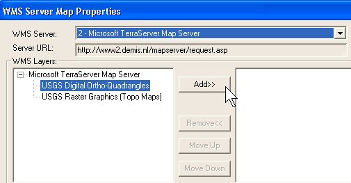
While a few things brought typed in "applause" from one or two attendees, it was hard to sense any strong excitement for the feature enhancements. The Tips and Tricks session that followed, from Tech Support Guru (honest, that's what they called him) Greg Bachinsky, was essentially a live demo of MapInfo Pro, which was a bit more interesting to watch than slides. Unfortunately, some folks had trouble accessing his screen. (I have a sense many of the participants and at least some of the presenters are rather new to the Webex technology.) Bachinsky presented a long customer locations/store locations demo that I confess I didn't completely follow. Binyamin returned to take questions and fired up 7.5 to show off some of the things of which we'd only seen slides. The questions were interesting. One fellow was concerned that he was going to be forced to use ESRI products because he couldn't effectively convert its data into MapInfo. He learned that upgrading from V6, which he was running, to the current V7 would give him direct access to shapefiles. A second question pointed out the labeling tools in ArcView 8.x that prevent "overposting" (labels blocking each other) and asked if that type of support was in 7.5. Binyamin noted that it was "identified as an area to address" but would not appear, along with other labeling enhancements, until the .NET release, currently slated for September 2004. (That statement brought some typed "groans" and suggestions that the .NET release was being delayed yet again.) The final question noted that the demonstration of accessing WMS servers remotely accessed imagery of an airport in New York. The question was if it was GlobeXplorer data, and if, with MapInfo 7.5 users receive access to nationwide imagery. I'm not confident I understood the answer correctly, but will report back next week. I can say that while the underlying technology, WMS was not all that exciting, the access to the data was definitely exciting. MapInfo is planning online User Group Meetings for the fourth Tuesday of every other month. A "repeat" of this event is scheduled for September 10. I also read on MapInfo-L that sessions have been scheduled at times friendly to other parts of the globe.

DO POSITIVE RESULTS AND ACQUISITIONS SUPPORT A TURN-AROUND? Upgrade numbers are 3% ahead of the last big release, Release 14, which Ralph Grabowski suggests comes from subscribers who automatically receive upgrades, whether they install and use them or not. On the other hand, new sales of AutoCAD 2004 and its family of products fell by 31% from the previous quarter. Perhaps the saturation of the market is to blame? Two other snippets are worth noting from the conference call. Grabowski noted that "at one time, Autodesk had a goal of 40% direct sales, but now has lowered the target to 20-30%." Is that change to quell reseller dissent or is the direct sales force not staffed up for the effort? I picked up on this point: Autodesk will be selling not AutoCAD LT, but full blown AutoCAD, through CDW (Computer Discount Warehouse) as a trial in the Northeast for a few months. Autodesk is still experimenting with its distribution channel. Also last week, GE Power Systems bought up its second GIS company, M.J. Harden Associates, Inc. based in Kansas City. In 2000 GE purchased Smallworld. M.J. Harden started life in 1956 as a photogrammetry company but grew to an IT solution provider supporting mapping, utilities/government and pipeline GIS service. M. J. Haden will become part of GE's pipeline integrity services division, PII Pipeline Solutions, based in the U.K. GE bought that company in 2002. M.J. Harden in some ways brings a parallel set of technology for the pipeline industry as Smallworld did for the electric arena. The mismatch, GIS industry people will note, is that M.J. Harden has been a longtime partner with ESRI (it won a 1999 ESRI Business Partner Foundation Award among its achievements), a traditional Smallworld competitor. If GE wants to sell both solutions to a single client, it will need to show how these fit together in the same enterprise solution. The other question is how GE will work with, or remove, M.J. Harden's traditional GIS services for government and mapping. A bit outside the GIS world, one smaller CAD company, International Microcomputer Software, Inc. also known as IMSI, based in Novato, California (that's just down the road from San Rafael, the location of Autodesk's headquarters) purchased CADKEY, based outside Boston. IMSI, which owns TurboCAD, a well-respected, low-cost CAD product available at the corner computer store, has had its ups and downs over the last few years. IMSI has acquired a number of popular titles including HiJaack, once a staple of graphics conversion, and sells a few other Turbo-related titles including TurboProject and TurboTyping. Most recently IMSI sold off ArtToday.com a subscription service for clip art and other graphic design goodies. CADKEY, a mechanical design company, has also had some ups and downs, but was amenable to the $2.5 million dollar offer. That may have been in part due to a legal loss that cost the company $5 million. Ralph Grabowski reports that CADKEY entered bankruptcy protection last week. CADKEY, back in the day was called Baystate Technologies, Inc., and was once a reseller of the CADKEY technology, before buying it from its originator in Connecticut. While acquisitions are a sign of economic activity, it's not clear these two are the type that would have occurred in a stronger economy. My gut feeling is that the economy made these two acquisitions more attractive than they might have been otherwise. I noted in the first issue of GIS Monitor, regarding the Smallworld acquisition, that "large multidisciplinary companies do not have a good record with GIS, especially GIS development." I'm thinking things may be changing as GIS nudges closer to traditional IT not only technically, but also "socially." I expect to see more "non-GIS" companies picking up geospatial companies that fit into their business lines. Recall that Marconi picked up Northwood Technologies and its product, Vertical Mapper, in 2001. The product was turned over to MapInfo earlier this year.

He was regular kid who grew up in and around Boston. He went to the University of Lowell before it was UMass Lowell. His first few jobs involved surveying. He got a PE in Structural Engineering. In the mid-1980s his company, Fay, Spofford & Thorndike tapped him to run the emerging CAD department since he'd "heard of" AutoCAD, and later handed him the key to the company's IT department. He led the Greater Boston AutoCAD User Group (now the Greater Boston Autodesk User Group) for ten years. That's where I met him in 1992. His surveying roots stayed with him and he taught Surveying I and II at night at UMass Lowell for many years. He used to joke about how it paid for his trips to fly kites in the desert outside of Las Vegas each spring and for trips to the Jersey Shore each Memorial Day. When I first learned about geocaching, he was the first one I notified. "We have to do that!" was his reply. He taught me about surveying and I taught him about GIS. We gave far too many talks on GIS and GPS to professionals, and even more on geocaching to young people. (I think there were a few presentations on kites and boomerangs in there, too.) When he wasn't immersed in geospatial pursuits he was playing with the latest hardware, software, digital cameras, MP3 players, or configuring or fixing his families', friends' and colleagues' techie toys. Payment for services was delivered in food (Pepperidge Farm Tahoe cookies for smaller jobs, or dinners that included lamb for larger ones). Bob Hogan died this week of cancer. He was 50 years old.

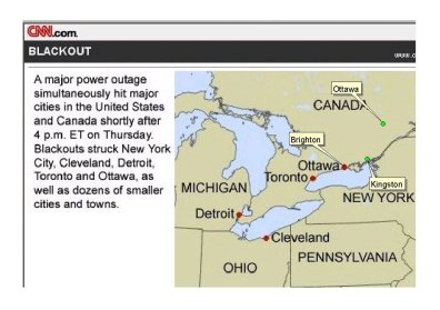
LETTERS "In the � map, the City of Kingston is labeled as Ottawa. Kingston was the capital of the province of Canada from 1841-1844."
While Kingston is probably the largest city in the area, the location was more properly identified as Brighton. This map from Jan Slaats of The Nature Conservancy, based in Minneapolis, clarifies that "Kingston is located on the eastern end of Lake Ontario. In the CNN map, Ottawa is placed in the position of a very small town named Brighton." Peter Van Demark at Caliper Corporation, and Nick Park of GeoFields each also receive an A in Canadian geography. � Here in the U.S., Jim Bash of the University of Illinois at Chicago straightened out my discussion of a misrepresented border of Indiana. I asked, "True or False: The border of Indiana to the north follows the edge of Lake Michigan." I concluded the answer was true. Jim explains I got it wrong. "Answer should be false. We all perceive Lake Michigan as the northern border of Indiana but Lake Michigan has to belong to someone and I think all the adjacent states have legal boundaries that extend out into the state. I routinely have to 'fix' TIGER files for Illinois counties to remover these borderssince we all want to see Chicago and surrounds (Cook & Lake Counties) as ending at the Lake edge. Of course the Lake edge varies from year to year and day to day (depending on Lake levels and erosion) so it wouldn't be a great legal boundary anyway!" � Sara Revell from the Ordnance Survey wrote about her frustration following a link last week. "In your Point of Interest re Virtual Tour Guide [last week], the link included connects to the NY Times, which you have to subscribe to in order to see the article. Could you not find a similar article that would be easier to access? Cornell themselves must have a press release about the study?" The editor replies: I understand your concern. After some years of writing "New York Times (free registration required)" I stopped noting that in GIS Monitor thinking most folks knew that was the case. (At Slashdot they were writing "registration, blah, blah...." but may have stopped that by now.) As an aside, of all the things worth registering for on the Internet, I think the NYT is one of the best. As for Cornell hosting a release on the project, no, I couldn't find one! I did find this article from May, which is not half as good as the Times piece. I supposed that's why the Times is the "paper of record," at least here in the States. � Heather Jernberg wrote to share some information on a grant from National Geographic that "supports efforts to engage K-12 students and teachers in the exploration of geographic skills and perspectives leading to an appreciation of the world, its peoples, and its resources..." Alas, the deadline for first-time applicants has already passed, but those who've applied in the past have until September 29th. � Kingsley Allan at the Illinois State Water Survey wanted to know more about GIS Monitor readers. "I'm sure I'm not the only one on the list wondering about the geographic distribution of these 13,500 GIS professionals. Please tell us if you dare." The editor replies: I put that question to GIS Monitor publisher Allen Cheves. He responds: Of over 13,500 persons currently receiving the Monitor: - Roughly 20% are international contacts, who are involved in the various geospatial professions. These contacts span more than 150 countries, and are mostly executive and managerial level professionals interested in North American developments in our business. - An additional 20% principally work in GIS, in North America. - Some 15% are involved with various government agencies involved with GIS, in the US. - The remaining 45% directly subscribed without providing "work area" information. These folks are almost all based in North America, and are dedicated fans of the Monitor. Folks in this portion of the list include many high-level geospatial vendors. We frequently write about these companies. Their executives, who enjoy (and sometimes flinch at) the analysis and insight the Monitor provides, also write back to us. � The editor also notes: And while we're at it, here's a question I receive periodically: "Did you write the article about�?" Just so it's clear, I write all of GIS Monitor every week, except where there's an explicit byline.

POINTS OF INTEREST Editing Reality. Some new technology called Tinmith from the new University of South Australia, incorporates a wearable computer with virtual reality glasses and a global positioning system (GPS). The idea is to allow users to look at the real world and then add new virtual worlds into it. Currently users wear a backpack and gloves to add and move the new objects, but the hope is to eventually make the systems smaller. E-911 in Canada. We read all about the U.S. challenges with E-911, but in Canada, there are similar challenges. The Canadian Radio-television and Telecommunications Commission on Aug. 12 ordered Canada's four national cell phone companies to provide wireless "enhanced 911 service" to their customers within six months to a year. The Red Line. They repaved and repainted the parking lot at my local grocery store a few weeks ago. I didn't think much of it until I walked there this past weekend. As you enter, there is a red line painted on the blacktop. Same with the exit. The remainder of the parking lot is fenced. When I walked out today I noticed the red lines. At the one near the entrance was a group of shopping carts. Then I saw the sign, "If removed from our parking lot, our shopping carts will lock." I tried to push the one that was just outside the red line. Indeed its wheels locked. I have to believe that when they were repaving, some type of sensor was put on the carts and under the red line. It made me think about other applications of this location-based technology. One of the current topics of controversy in my city is bicycle riding on the sidewalks in the business district. (It's legal outside the business district, though one fellow nearly took out my then toddler-sized nephew a few years ago.) I wondered if when bikes were registered (I don't believe we require that in Somerville, but I've been in cities and towns were that was strictly enforced) the tag could contain a sensor that would cause some action when a rider traveled the sidewalks of the business district. Over in Britain, The Sun reports about the Electronic Vehicle Identification, invented by the Association of Chief Police Officers on the orders of Transport Secretary Alistair Darling. Cars will carry a chip and report "rule breaking" to sensors on the side of every road. Then, fines will be imposed. According to the article the sensors will report "each time a motorist drifts over a speed limit, wanders into a bus lane or even stops on a yellow line." Gillette pulls RFID Tag Test. I reported on Tesco's use of RFID tags on Gillette Sensor razors in its store in Cambridge, U.K. a few weeks ago. Recall that a picture was taken of the buyer, then, ideally matched with another picture of the shopper leaving the store. This week, after protests (images here), Gillette ended the trial. An article at IndyMedia notes there are continued fears, however as the proposed EU Intellectual Property Enforcement Directive has specific rules prohibiting consumers from messing with the tags. The document is mostly about IP and not tampering with copy protection, but also apparently extends to RFID tags.
NASA Asks the Public Where? NASA is asking the public to suggest where to explore on Mars with the Global Surveyor spacecraft's camera. The craft has been in Mars orbit since 1997 and has made some 20,000 orbits of the planet. Images can resolve features that are small as a school bus. Details on how submit suggestions are here, and already collected images are here. At left, this Mars Orbiter Camera (MOC) image shows a plethora of polygonal features on the floor of a northern hemisphere impact crater. Source: NASA/JPL/Malin Space Science Systems. Whence the Tablet PC? I recall noting recently that I don't know a single person who has a Tablet PC. Now that's not strictly true, as I do know two people who have them who work for a software vendor that develops Tablet PC software, but that doesn't count. The figures suggest that most of you don't know people with Tablet PCs either. IDC reports that Tablet PC sales fell by 31 percent in the second quarter of 2003. They accounted for less than one percent of the total notebook market. Notebook sales, on the other hand, jumped by 39 percent in the same quarter. The market for Tablet PCs are specialized users, ones that need to "walk and work" at the same time, says Alison Heath, account manager at Fujitsu Siemens. Handheld proponents argue that technology is the way forward, not Tablets. Stay tuned. Attend AU Free. Autodesk's Infrastructure Solutions Division (ISD) will be hosting its annual Worldwide GIS User Conference in conjunction with Autodesk University (AU). The events will be held at the MGM Grand in Las Vegas, Nevada, December 2-5, 2003. If you are going, you have a chance to go for free. Here's how: -Register for Autodesk University via the AU website on or before October 9, 2003. Wi-Fi Helps Businesses. The New York Times (free registration required) has an interesting article highlighting how businesses, notably restaurants, are using Wi-Fi to increase sales, speed order delivery and decreases errors. Waitstaff key-in orders via Palm Pilots or iPAQs and have reported higher tips with the new system. Even experienced workers are noting they'd not go back to pen and pad. Perhaps more interesting from a technology trend standpoint is the fact that many users are converting from older proprietary wireless solutions to the new open standard, Wi-Fi. Survive the Viruses? The recent rash of viruses/worms including Blaster and SoBig.F hopefully has spurred anyone still out there without virus protection to get it. This event also highlighted the need to download and install security patches regularly. My laptop faired the storm quite well. I credit four things for coming through intact. (1) I still run Windows 98, which was not susceptible to Blaster. (2) I bought and annually update my subscription to Norton Anti-Virus. The software (and most other Anti-Virus software) automatically and regularly updates its virus definitions. These are used to scan incoming e-mail, as well as the machine's hard drive. The anti-virus programs have made this so easy and automatic I don't even have to worry about my father getting viruses anymore. (3) I'm a loyal user of ChoiceMail, which blocked the vast majority of tainted e-mails from reaching my InBox. I say vast since some were "bounced" e-mail that theoretically came from me. But fear not, they'd already had their viruses stripped off by Norton. (4) I use a firewall, Zone Alarm, which lets me know when a software program comes knocking at my computer's virtual door, or when a program on my computer wants to communicate with the Internet without my explicit permission. Should my army of software have failed against the virus, what would I have done? I would have been glad that I make weekly CD backups.
� Announcements Spatial Data Technologies (SDT) announced a business partner agreement with Trimble to develop and integrate SDT products with Trimble's GeoExplorer CE series and Recon handhelds. In this new relationship, SDT will provide Trimble's rugged handhelds as part of a complete enterprise data management solution for oil and gas, forestry, agriculture, natural resource, and utility clients in the public and private sector. The Urban and Regional Information Systems Association (URISA) announced the winners of its 2003 Exemplary Systems in Government (ESIG) Awards. The awards recognize exceptional achievements in the application of information technology that has improved the delivery and quality of government services. DigitalGlobe has announced that it plans to install a ground station in Wilkes-Barre, Pennsylvania to receive data from the QuickBird high-resolution imaging satellite. Scheduledto be operational by the end of the third quarter, 2003, this ground station provides additional operational capability to DigitalGlobe's other ground stations located in Norway and Alaska. Intergraph Mapping and Geospatial Solutions announced that Cobb Electric Membership Corporation (Cobb EMC) has purchased Intergraph's InService suite for outage and mobile workforce management. Located in Marietta, Georgia, Cobb EMC is an electric cooperative serving more than 170,000 customers in five metropolitan Atlanta counties. ESRI announced it has updated its corporate website. I believe it was updated around the time of the User Conference. infoUSA, a provider of proprietary business and consumer databases and sales and marketing solutions, and Motorola, Inc., announced the incorporation of infoUSA's Point-of-Interest (POI) data in the recently released Motorola VIAMOTO phone-based wireless navigation system. Avis Rent A Car will be the first to feature the VIAMOTO service as "Avis Assist".

� Contracts and Sales Geo InSight International, Inc. announced that it has teamed with Genesys International Corporation, Ltd. to enhance the access and use of the Bureau of Land Management's (BLM) aerial photography archive. The project is a pilot study that will deliver at least 40 digital orthophotos covering areas in Colorado, Utah, and Wyoming as well as a flight line and photo center geographic database. LuciadMap has been selected by the Dutch city of Tilburg to build and integrate its next generation GIS application. � Products Bentley announced the release of Bentley PowerSurvey. It's a low-cost, CAD-based solution to capture, transfer, and analyze survey data. Dakota Worldwide Corporation announced the release of the latest 108th congressional district file in MapInfo format. Learn SVG: The Web Graphics Standard is a new book available in electronic and print formats. It's the first in a series on SVG from LearnSVG.com. Leica Geosystems GIS & Mapping announced that ERDAS IMAGINE V8.7 will be available in fall 2003. The latest version of ERDAS IMAGINE will feature JPEG2000 support (including GeoJP2), further improvements to its mosaic tool, and a faster, smoother multi-threaded IMAGINE Geospatial Light Table (GLT) viewer. Set to be simultaneously released with the Leica Photogrammetry Suite, ERDAS IMAGINE 8.7 will be fully compatible with Leica Geosystems' new process-driven photogrammetric software suite. The Q2 2003 InfoNetrix Business Horizon Reports cover the TDMS (T & D Management Solutions) and GMCS (Geospatial & Mobile Computing Solutions) markets. The research documented record 397 projects valued at $123.5 million. Data from the Shuttle Radar Topography Mission, a global data set, called "SRTM30," covers the earth between 60 degrees north and 60 degrees south of the equator. I could find no information on availability. The next release of Cadcorp SIS, v6.1 will support the OpenGIS Web Map Context document specification. PCI Geomatics announced the release of its latest PCI Software Development Kit (SDK). The new kit supports Geomatica 9.

� Events ESRI, Science Applications International Corporation (SAIC), Woolpert LLP and Bradshaw Consulting Services (BCS) are hosting a one-day workshop on applying geographic information system (GIS) tools and practices to homeland security and emergency response programs. This workshop will be held September 12, 2003, from 8:00 a.m. to 4:00 p.m. in Atlanta. The event is free of charge, but seating is limited. The International PROGIS Conference will take place in Faak am See/Carinthia/Austria September 10-12, 2003. The conference will feature discussions of WinGIS 2003 and the new PROGIS MapServer. AMD announced its AMD Athlon 64 Processor High-Tech Treasure Hunt, a virtual GeoCaching contest where participants answer clues to find 64 global locations which have significance to technology, 64-bit computing, or AMD. Each correctly identified and submitted location enters eligible participants in a grand prize drawing for an AMD Athlon 64 processor-based desktop system and $6,400 cash. Contest information and complete rules are online. The contest will conclude on September 15, 2003. � Education and Training � Hires and Appointments John Asaro has joined Leica Geosystems as vice president, marketing, for the Americas. He comes from a professional outdoor equipment catalog and Internet company. He replaces Hugh Baertlein, who has been promoted to global sales manager for Leica Geosystems' Consumer Products Division.
ADVERTISE WITH US
CONTACT
SUBSCRIBE/UNSUBSCRIBE |