
|
|
News Briefs, Back Issues, Advertise, Contact, Subscribe/Unsubscribe If, for some reason you cannot read this document, visit: http://www.gismonitor.com/news/newsletter/archive/091505.php
Editor's Introduction 
 Hurricane Katrina: Geospatial Responses The geospatial community is mobilized to assist in recovery from the devastation inflicted by Hurricane Katrina. Following are excerpts from a few of the descriptions I received from various companies as to what they are doing to help. Applanix: "Our involvement with the Hurricane Katrina recovery effort has been via the use of one of our digital aerial imaging systems (DSS Digital Sensor System), currently operated by NOAA's Remote Sensing Division, to support national security and emergency response requirements. The system is designed for rapid response image acquisition and is installed aboard one of the agency's Citation jet aircraft. The system will produce high-resolution directly georeferenced digital imagery in situations where survey control cannot be obtained, as a result of the hazardous conditions on the ground. The agency's Citation aircraft was pre-positioned behind the storm in order to be airborne immediately after Katrina had passed through the area. The first 350 of approximately 5,000 aerial images were made available via the Internet within 24 hours after acquisition. In addition, Google Earth has included the imagery as part of its image data bank, which can be used to view the Gulf Coast before and after the storm. According to NOAA the principal users of the imagery are members of the general public with a direct connection to the disaster area who want to see their homes and neighborhoods, the Department of Homeland Security, the National Geospatial-Intelligence Agency (NGA), the Federal Emergency Management Agency (FEMA), and the Federal Aviation Administration (FAA), which use it for storm damage assessment and planning." DeLorme "is responding to government agency requests to expedite delivery of needed GIS software and data sets specific to the Gulf Coast region in support of recovery and insurance claims processing. DeLorme staff is available for customer service, tech support and training in support of recovery activities." ER Mapper: "License codes and support for ER Mapper products is available free of charge to agencies assisting in the Hurricane Katrina disaster. Please send requests to [email protected]." ESRI "is providing GIS software and services support to organizations responding to Hurricane Katrina. Similar to ESRI's efforts in responding to other emergencies including last year's hurricane season, government agencies and private entities can contact ESRI for on-site technical support, temporary key codes, and other assistance. This support is available to any organization, regardless of its GIS platform. Agencies in need of GIS assistance should visit the ESRI website, which also contains useful information such as hurricane advisories and response information, hurricane maps and images, and maps for journalists. This includes a Hurricane Katrina Disaster Viewer that allows users to view data and imagery for the affected areas and the southeastern United States and create customized maps and demographic reports based on individual requests. ESRI has provided access to Business Analyst Online for use by any economic development agency, urban and regional planning agency, trade association, or interested party who wishes to examine the population demographics, housing, and businesses that existed in the Gulf Shores area prior to Hurricane Katrina. The site also contains links to government and private sector websites, Web services, reports, and other information resources, as well as information for ESRI business partners or corporate alliances that would like to offer software, hardware, services, or imagery. As part of ESRI's commitment to disaster preparation, response, and recovery, ESRI is actively supporting local, state, and federal agencies and private organizations responding to Hurricane Katrina, including the Federal Emergency Management Agency (FEMA) and Emergency Operations Centers (EOCs) in Alabama, Louisiana, Mississippi, and other affected areas. ESRI has provided software, mapping and analysis services, technical expertise, field GIS, Web services, and more. Applications include assigning equipment, organizing and deploying personnel, evacuation planning, identifying emergency shelters, hurricane modeling and tracking, damage assessment, and infrastructure restoration." Intergraph Corporation "is working with local, state, and federal relief agencies in responding to Hurricane Katrina's devastation. The company is providing technical assistance and monetary aid in support of the relief, recovery, and rebuilding efforts on the U.S. Gulf Coast. ... Intergraph is working with several of the region's public safety and emergency response agencies to get their critical command and control centers back on line in order to respond to relief efforts and other emergency incidents. The company has also deployed several of its geospatial, transportation, and utilities experts to directly assist in the organization and distribution of critical information needed in the assessment of the damage and the prioritization of the relief, recovery, and rebuilding efforts in the region. In addition, the company is offering resources to its regional oil and process customers to assess storm damage and identify areas of repair, allowing them to perform start-up activities and establish commissioning systems to more rapidly get these plants back on line." Leica Geosystems Geospatial Imaging "is actively supporting government agencies and disaster relief organizations responding to this emergency situation. Temporary licenses, technical support, and other assistance are available for any organization with geospatial information needs while participating in the relief effort. If your organization is in need, or if you would like more information, please e-mail: [email protected] Leica Geosystems Geospatial Imaging provides tools for aerial photography and remote sensing, photogrammetry and GIS to government and commercial organizations. These can be used to acquire, triangulate and process imagery, providing elevation models for 3D visualization and orthophoto production. Additionally, this software can:
LizardTech "makes software tools for compressing and working with large aerial and satellite image sets used by geospatial professionals in both private enterprise and local, state, and federal government. LizardTech has donated licenses of its GeoExpress with MrSID software to agencies involved in ongoing relief efforts in New Orleans as a result of Hurricane Katrina's devastation. These agencies are using GeoExpress to convert massive datasets from raw format to LizardTech's industry-standard MrSID format in support of other agencies that require analysis or survey of areas within the region affected by the disaster. In assisting ATMOS Energy Louisiana, GE Energy acquired approximately a terabyte (a thousand gigabytes) of georeferenced aerial imagery of the region, which it is rushing to convert to MrSID format so that it can be viewed in conjunction with New Orleans' utility and infrastructure data, which in turn will enable ATMOS to efficiently run valve isolation on its gas mains. The National Oceanic & Atmospheric Administration (NOAA) is using GeoExpress to compress satellite imagery from various commercial and military sources so that it can be used in GIS applications on laptops and other mobile devices in the field for 'before and after' analysis of the affected areas." MapInfo: "MapInfo Corporation is volunteering its services to assist with the recovery efforts. We can assist organizations with:
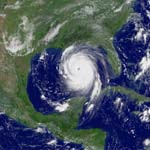
The National Oceanographic and Atmospheric Administration (NOAA) "has been very involved with Hurricane Katrina Emergency Response. We have been acquiring data since August 30, following landfall of the storm. We have collected over 7,000 digital images with the Applanix Emerge Digital Sensor System. These images can be found at http://ngs.woc.noaa.gov/katrina/. The principal clients of this imagery have been FEMA, USACE, local emergency management agencies, USGS, and the general public." Space Imaging "cleared its IKONOS satellite collection schedule in the southern United States to shoot its first images of the Hurricane Katrina aftermath on Tuesday, August 30. Because of lingering clouds, the only cloud-free image was over Mobile, Alabama. Orbital paths did not allow IKONOS to image the next two days. For Friday, September 2, Space Imaging developed an aggressive collection plan to shoot large swaths of imagery from Mobile to New Orleans in a single pass totaling 12,500 square kilometers. Space Imaging continued to shoot on September 5, 7, 8, 10 and 11. So far, the agility of the IKONOS satellite has allowed it to image more than 88,300 square kilometers (34,000 square miles) of the Gulf Coast. Even though many of these images are of the same area along the Gulf Coast, the total area collected is a little more than the size of South Carolina or of Austria. Space Imaging and the National Geospatial-Intelligence Agency (NGA) worked closely together to prioritize the areas that needed to be collected. As imagery is taken, it is delivered the same day to the NGA through a secure electronic connection. Space Imaging accomplished this same-day delivery even for the large-area collections on September 2 (12,500 sq km), September 7 (14,500 square kilometers) and September 8 (17,800 square kilometers). Because of a lenient licensing agreement with the NGA, imagery from IKONOS is also distributed to other federal agencies and contractors supporting the relief efforts through the NGA purchase. In one instance, on Saturday, September 3, Space Imaging shipped out 10 hard drives, each filled with 75 GB of data including newly collected IKONOS OrthoKit imagery, archive IKONOS ortho-mosaic imagery, archive 5-meter ortho-mosaic imagery from the IRS satellites, and digital elevation models. The hard drives were sent to NGA personnel and support contractors in the field, and other support agencies including the Federal Emergency Management Agency, Department of Homeland Security, U.S. Geological Survey, the U.S. Northern Command, the U.S. Army Space & Missile Defense Command, and the U.S. Army Corps of Engineers.Space Imaging also established a high-bandwidth Internet site to host gigabytes of imagery data for direct download by users authorized by the NGA. Reports from agencies say IKONOS imagery is being used to create accurate maps of the area at large. These maps are allowing first responders to assess the overall damage and decide where to focus resources and locate staging areas. Space Imaging received numerous requests to share any imagery with the public since so many of the estimated 1.5 million displaced residents did not know whether their houses were destroyed. A large area of New Orleans taken on September 2 along with many before-and-after images of Gulf Port, Biloxi, Mobile, and Pascagoula are available in a zoom viewer on Space Imaging's Web site. The viewer allows visitors to zoom in and explore large areas in an easy-to-use, Flash-based interface without having to download large files. Much of this imagery was also used by national and international media to help better report on this once-in-a-lifetime story." 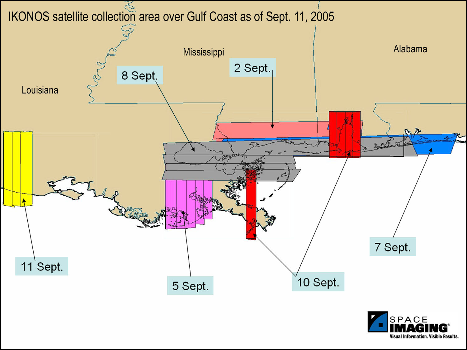 Click on the image to enlarge it. Image courtesy of Space Imaging.
Hurricane Katrina: Engineers Map Damage to Critical Structures On Monday I spoke with Arthur J. Lembo, Jr., Ph.D., a senior research associate and senior lecturer in the Department of Crop and Soil Sciences at Cornell University, in Ithaca, New York, where he teaches GIS, GPS, and remote sensing. Previously, he worked in private industry, for Bowne Management Systems, building GIS for private and public organizations. Lembo is also associated with the Multidisciplinary Center for Earthquake Engineering Research (MCEER) as a co-principal investigator for a number of research projects. MCEER is a consortium of universities funded mostly by the National Science Foundation (NSF), with additional funding from New York State, the Federal Highway Administration, the Federal Emergency Management Agency (FEMA), other state governments, academic institutions, foreign governments, and private industry. The Center studies ways of reducing the vulnerability of buildings and infrastructure to earthquakes. Recently, however, it has expanded its scope to also study ways of hardening against other "extreme events" — both natural and man-made. GIS is one of the Center's key tools. 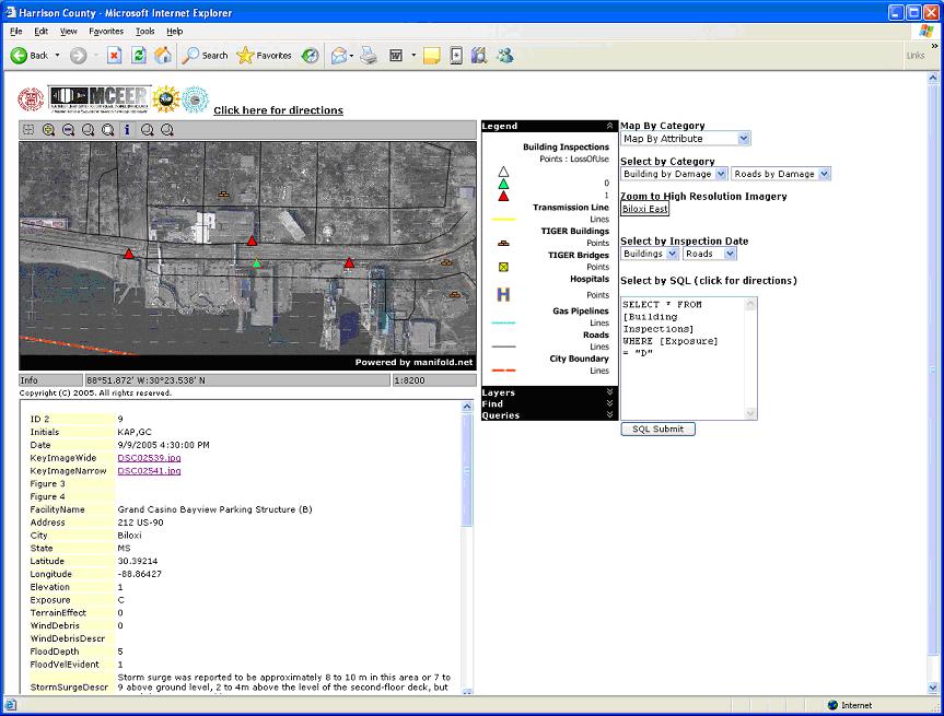 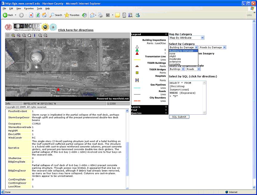 Click on the images to enlarge them. Images courtesy of MCEER. Shortly after Hurricane Katrina hit the Gulf Coast, the MCEER team asked Lembo to handle all the mapping and Internet Map Server (IMS) applications for field teams going down to Mississippi — a project similar to what he had done following the Indian Ocean tsunami. He was helped in this project by the extensive geo-database that the state of Mississippi had already made available online, including roads, schools, hospitals, and other infrastructure. On September 6 a team from MCEER (usually pronounced "Em-sear") began to survey Mississippi coastal communities, collecting information on the status of critical infrastructure, and keying it to precise locations determined by GPS receivers. The team is led by Gilberto Mosqueda, of the State University of New York at Buffalo. It includes experts from the same university and from the California Institute of Technology, Texas A&M; University, the New York State Department of Transportation, and a private company called Image Cat Inc., which specializes in using remote sensing for damage assessment. 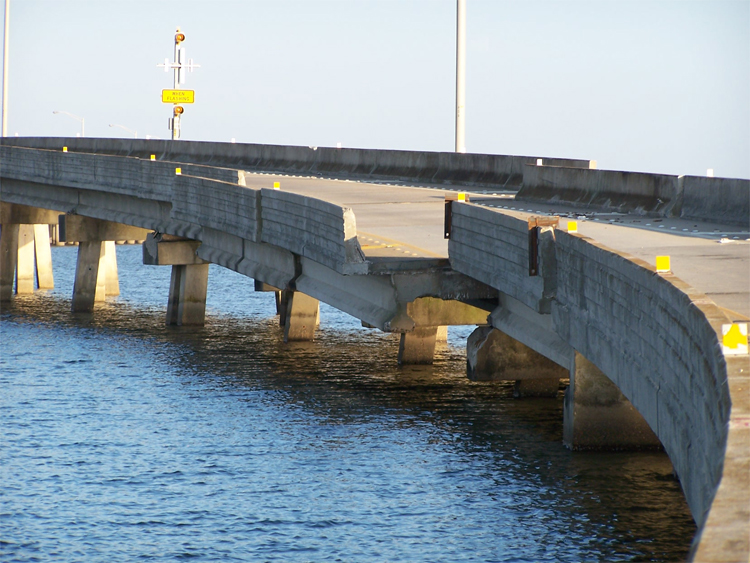 Click on the image to enlarge it. Image courtesy of MCEER. The information collected by the team is relayed daily to the Earthquake server at the University of Buffalo where it is stored in a SQLServer database. Lembo's application uses Manifold GIS to dynamically link to the Buffalo server and incorporate the field collected data within the GIS Internet Map Server application. Initially, the team is concentrating on the cities of Biloxi, Gulfport, and Long Beach. "They are on the ground with GPS receivers and hand-held data recorders," Lembo told me, "looking at critical infrastructures, such as hospitals, bridges, schools, and hotels. They are writing narratives about structures, plus taking digital photos, to help engineers better understand the resilience of different designs. For example, did the buildings have shutters and, if so, did they help?" "Most of the information that is being collected is perishable," Lembo explains, "in that it will be soon gone from people's memory. The team is getting an understanding of the situation as close to the date of the disaster as possible." In addition to aiding in reconstruction, this information is important for engineers for future reference. "Not all the engineers can visit the site," Lembo adds. "Using narrative descriptions, GIS, and digital video and photos, engineers from other institutions can evaluate the damage and make recommendations on how to make infrastructure more resistant in the future. It is acting as a collaborative tool." 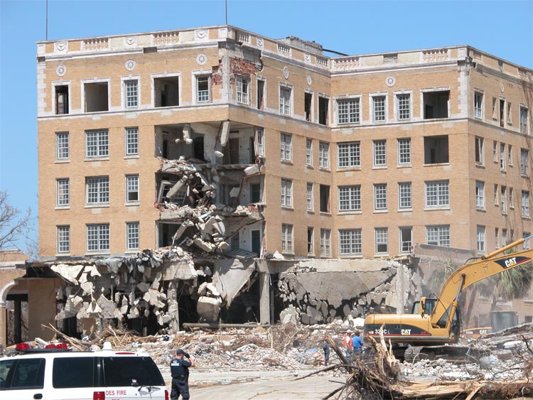 Click on the image to enlarge it. Image courtesy of MCEER. Users of the website can turn the various data sources on and off on a map displaying, for example, hospital locations, roads, waterways, or power lines. They may click through to high-resolution satellite images showing the degree of inundation of an area, or digital photos and video taken by the MCEER team of individual buildings, bridges, and other key infrastructure components. For the time being, Lembo said, the website will be made available only to professionals, to minimize demand on the server. Eventually, it will be accessible through a link on Cornell's Network for Earthquake Engineering Simulation (NEES) site. NEES, also funded by NSF, is a network of laboratories contributing to the MCEER effort. "Our structural engineers are filling out reports in field databases and taking pictures and video," Lembo told me. "This information is sent to Buffalo and stored in SQLServer." To create the Cornell website, Lembo used Manifold, a low cost commercial GIS. "With Manifold, we dynamically link our IMS application to the SQLServer database in Buffalo and render maps and reports. We can also link to ERMapper's ECWP (Image Web Server) to now look at gigabytes of post-hurricane imagery (on remote servers) right within the Manifold application, and serve that data in our IMS application. The IMS application also allows for different thematic rendering and spatial queries of interest, such as 'show all buildings that have extreme damage, moderate damage,' etc. Finally, we have a free-form spatial SQL box so that other users can ask all kinds of questions. This is actually my favorite part!" Lembo chose to use Manifold GIS because, he told me, "its architecture allows us to rapidly develop IMS sites in response to emergency situations. With Manifold, we were able to develop the entire application, with one person, in about 24 hours — just as we did for the tsunami site last December." He also listed several other reasons for this choice: cost ("At $245, it is a steal."); the ability to use spatial constructs directly within SQL; its Integrated Map Server architecture ("Because Manifold GIS is the map server, everything we do in the GIS is immediately available in our Internet application."); and tight integration with Microsoft: "For example, Manifold can automatically link with Excel, and create dynamic drawing from Excel spreadsheets. In turn, Excel, through its Web Query capabilities, can dynamically read Web pages. Therefore, we use Excel to hit a Web page, and then Manifold polls the Excel application every 10 minutes and refreshes the map. So, we are able to use Manifold to dynamically display data from other websites, without the need for any programming." 
MetaCarta's technology will enable WME users to search for documents within a specific geographic region, based on geographic references within reports, briefings, presentations, permits, and other text data from the EPA. The new system will first be tested by EPA internally, before being deployed for public access through the agency's website. MetaCarta already has provided analysis tools to many programs in the intelligence community and Department of Defense. According to Dave Catlin, an information manager and specialist who is part of the Internet Geoservices Team at the EPA, "If it works well, we will make it a permanent component of WME." Practically everything that the EPA does is spatially related, he told me. "Environment is all about location." I asked Catlin how his agency plans to prioritize which documents to feed into MetaCarta and whether he ultimately expects all of the EPA's public documents to be searchable. The initial focus, he told me, is on public access to documents via the Internet; later on, the project will probably be expanded to include internal documents for restricted access by staff via an intranet. So far the EPA has fed about 300,000 documents into MetaCarta, across all subject categories and types of media. The initial purchase of the software and a one-year contract cost the EPA about $80,000. The agency will probably spend at least that much internally on additional software development to further customize the project and integrate it into its systems. Then, according to Catlin, the future of the project will depend on how useful it will be to the EPA's different programs. Did the EPA approach MetaCarta or vice versa? It was mutual, Catlin told me. "We were aware of MetaCarta and felt that there were a lot of potential uses of its technology within EPA." Now that the project has begun, Catlin says, "We are pretty excited. It is a unique product that can help us in a variety of ways." One use is to support emergency response. The EPA's system can pull in FEMA flood data from the Geography Network, water monitoring data from the USGS, images from TerraServer, and other data, such as population density, from an Oracle database. The "look and feel" of the new interface, after the integration of MetaCarta's technology, will probably be a hybrid between the current WME interface and the standard MetaCarta interface. Catlin hopes that the integration will be complete by the middle of October and that the new portal will be completely up and running by the end of the year. Randy Ridley, MetaCarta's Vice President and General Manager of Public Sector Systems, confirmed this timeline and added that he hopes the system to be deployed enterprise-wide next year. Ridley sees this contract as important strategically for MetaCarta because the EPA is the company's "first non-security client" and this "validates [MetaCarta's] technology." Additionally, unlike most of MetaCarta's other deployments, this one is "very public-facing," as the EPA seeks to communicate with the public. This is particularly important for the company because most of its current deployments, which have a total of about 100,000 users, are classified, so it cannot use them to show off its technology. Why was the EPA MetaCarta's first non-security government client? Ridley told me that he has been talking to the U.S. Department of Agriculture, the U.S. Department of the Interior, and other federal departments and agencies. "Different government agencies have different monies available," he told me. "Who can tell why one moves first? All of these agencies have a public-facing side." "If we were already deployed," Ridley told me, "we could be helping with the Hurricane: we could retrieve every single report and study ever done on the water in the area. We could take any kind of documents about toxic deposits in New Orleans." I asked Ridley whether MetaCarta has any intention to begin crawling the Internet, like Google. He told me that the company's "Federated Search" approach allows one MetaCarta box to talk to another one at a different company or agency. "This is in the roadmap. I can't tell you when it will come about." MetaCarta also already has crawlers that can bring in documents from the Web — and do so depending on each client's preferences and specifications. "Our technology is perfectly capable of working in either environment," Ridley told me, meaning that it can either digest the contents of a client's internal documents or search the Web. Focusing on the latter, however, and making the system available to the public, supported by advertising, he pointed out, would be a completely different business model. Briefly Noted The cover story in the October issue of Technology Review is titled "Killer Maps" and subheaded: "Google, Microsoft, and Yahoo are racing to transform online maps into full-blown browsers, organizing information — and, of course, ads — according to geography. The likey winner? You." Schuyler Erle, chief engineer at Locative Technologies and co-author of Mapping Hacks is quoted as saying "Maps were only created by professional cartographers and professional GIS people. What has happened because of Moore's Law is that people now have the computing power on their desktops to manage the vast amounts of data that are required for digital cartography. Maps are increasingly a 'read-write' medium. That changes how we interact with them and the impact they can have on our everyday lives." GEOSPATIAL RESPONSES TO HURRICANE KATRINA In response to the Hurricane Katrina disaster, the GISCorps of the Urban and Regional Information Systems Association (URISA) has provided nine additional volunteers to function as map production specialists. A few of the volunteers are now stationed at the Emergency Operation Center (EOC) in Jackson, Mississippi, and several were deployed to five other county EOC offices (in Stone, Pearl River, Jackson, Hancock, and Harrison counties) on the Mississippi coast line. This group's average years of experience is about ten years and they come from Colorado, Arkansas (2), Texas (2), Alabama, Illinois, Kentucky, and Washington, D.C. Cragin Knox, Administrator for the Mississippi Coordinating Council for RS/GIS, recently recognized the contributions of the GISCorps volunteers: "... express my sincerest thanks for the efforts of the GISCorps volunteers tasked to the Mississippi recovery program. You can not imagine how much better things are beginning to function (from a GIS standpoint) here at the MEMA Command Center." Most of the first group of deployed volunteers, who were in Jackson by Thursday, September 1, have returned home. For more volunteer reactions and information from the second deployment, visit http://www.urisa.org/katrina2.htm. GISCorps volunteers from both this relief effort and the tsunami relief effort will be present at URISA's annual conference in Kansas City, Missouri next month. The conference committee has re-organized its program schedule to accommodate their important presentations. Bentley Systems, Incorporated will provide special assistance to architectural, engineering, and construction (AEC) firms that have been displaced by Hurricane Katrina or are contributing to rebuilding efforts in the Gulf Coast region. Realizing that AEC professionals in communities hard hit by Katrina have undoubtedly lost most or all of their technology resources, Bentley will make available to them, at no charge, the design software they'll need to get back to work. In addition, the company will extend this assistance to organizations helping restore infrastructure along the Gulf Coast. The software, which includes MicroStation, and 60-day renewable licenses are available for immediate download. Dynamix Corp. — an SBA HubZone Certified Small Disadvantaged Business that specializes in providing bio/environmental, Information Technology, and GIS services to federal government entities — is providing federal military and civilian agencies with geospatial map information of the Gulf Coast areas devastated by Hurricane Katrina. The company has focused on supporting the U.S. Geological Survey (USGS) by providing integrated geospatial infrastructure information with post-hurricane commercial satellite imagery over inundated areas, particularly the greater New Orleans region. Dynamix generated current condition maps and provided them to the National Guard in support of recovery efforts in St. Bernard Parish. It is also using Web technology to provide the military with on-line situational maps depicting flood inundation zones, critical infrastructure information, and other map-based information. The USGS mapping project is the second Katrina recovery operation in which the company is involved. Last week, a Dynamix Bio-Hazard team from Dallas arrived in New Orleans to begin removal of human remains and infectious materials from hospitals and other sites in the city. Those activities are expected to continue for more than a month. CONTRACTS & COLLABORATIONS ORBIMAGE Holdings Inc. has entered into a definitive agreement to acquire substantially all of the assets of Space Imaging LLC. The total consideration for the transaction is approximately $58.5 million less amounts which will be paid by Space Imaging on its existing debt prior to closing as well as certain other adjustments. The transaction is subject to government regulatory approvals and other customary closing conditions. ORBIMAGE is optimistic that such conditions will be satisfied in time for the closing to occur on or prior to December 31. Denver, Colorado-based Space Imaging is a supplier of visual information products and services derived from space imagery. The company launched the world's first one-meter resolution, commercial Earth imaging satellite, IKONOS, in 1999. It is a privately held company with resellers and over a dozen international affiliates and ground stations around the world and provides satellite imagery and imagery products to a wide variety of governmental and commercial customers both in the United States and internationally. ORBIMAGE is a provider of Earth imagery products and services, with digital remote sensing satellites and an integrated worldwide image receiving, processing, and distribution network. In addition to the high-resolution OrbView-3 satellite, which is capable of measuring, mapping, and monitoring objects smaller than automobiles and spectrally differentiating thousands of land use/land cover types, ORBIMAGE also operates the OrbView-2 ocean and land multispectral imaging satellite and the SeaStar Fisheries Information Service, which provides maps derived from essential oceanographic information to aid in commercial fishing. GlobeXplorer has acquired a 100 percent interest in AirPhotoUSA LLC. Financial terms of the deal were not disclosed. The acquisition will combine GlobeXplorer's Earth imagery and property information Web services with AirPhotoUSA's aerial map production and sales expertise. Both companies will remain focused on their core capabilities, while leveraging the strengths of each others' spatial data products and services. Working within the Real Estate Information division of Stewart Information Services Corp., GlobeXplorer's integration of AirPhotoUSA will be productized inside several nationwide and international initiatives. GlobeXplorer and AirPhotoUSA will remain based in their home offices of Walnut Creek, California, and Phoenix, Arizona, respectively. MDA's Geospatial Services (formerly RADARSAT International) will extend its RADARSAT-1 oil spill monitoring and detection services to the Canadian Arctic region in response to Transport Canada's expansion of the National Aerial Surveillance Program (NASP) coverage to this area. The goal of NASP is to detect and prosecute polluters in the maritime environment through the use of aircraft, surface vessel, and satellite monitoring programs. The satellite monitoring component of NASP is embodied in the Integrated Satellite Tracking of Polluters (ISTOP) program led by Environment Canada. ISTOP is supported by Canada's RADARSAT-1 satellite, which acquires synthetic aperture radar (SAR) data over NASP coverage areas on a daily basis. Once the RADARSAT-1 data is received by MDA, image analysis experts analyze the data for potential oil pollution events. Time from data reception through image analysis to final delivery of reports to partners can be in as little as 1.5 hours. According to Jeff Hurley, Senior Project Manager of MDA's Geospatial Services International "By notifying the authorities - often the patrol aircraft directly - with up-to-date information, NASP is able to act on potential pollution incidents as they occur." Leica Geosystems Geospatial Imaging will partner with Visual Learning Systems, Inc. (VLS) to resell VLS Feature Analyst and LIDAR Analyst as add-on programs for ERDAS IMAGINE and ESRI ArcGIS. Feature Analyst is an automated feature extraction program that works seamlessly with ERDAS IMAGINE and ArcGIS. The automation saves users time over traditional collection methods in feature extraction and in editing and attribution. The LIDAR Analyst extension provides 3D feature extraction capabilities for airborne LIDAR data with tools for DEM editing and bare earth extraction. The VLS extensions available for purchase through Leica Geosystems are Feature Analyst Pro for ArcGIS, Feature Analyst Standard for ArcGIS, Feature Analyst Pro for ERDAS IMAGINE, Feature Analyst Standard for ERDAS IMAGINE, and LIDAR Analyst for ArcGIS. LIDAR Analyst for ERDAS IMAGINE will be released shortly. KPN, a telecommunications company, has awarded a major GIS contract to Infotech Enterprises, India's largest geospatial services company. Valued at several million euros and with a tight schedule of 18 months, this represents one of the largest, single-vendor GIS contracts awarded by the global telecom industry to an offshore services company in recent years. Infotech will provide a range of data management services for KPN's existing Access Network. An offshore production team of around 300 data specialists, based in India, will perform conversion services remotely, to digitize the existing plans of KPN's telecom network. Autodesk, Inc. will provide integrated geospatial solutions with Oracle to enable customers to maximize operational efficiencies based on a wealth of location and structural data. The two companies will work together to market solutions in strategic markets such as government, utilities, telecommunications, and transportation. The combined solutions, which include Autodesk geospatial software and Oracle database and spatial technology, offer customers the ability to create, manage, and share GIS and CAD data throughout the organization in a single, open, standards-based environment without additional investment or expertise in proprietary software and systems. Metrogas, the largest natural gas distribution company in Chile, has completed implementation of ArcFM. This new solution is part of an enterprise GIS and provides the company a complete utility-specific system for modeling, editing, maintaining, and managing facility asset data. Metrogas distributes gas to commercial, residential, and industrial sectors in the city of Santiago, and manages 4,800 kilometers of gas pipes that serve more than 320,000 consumers. Metrogas used CAD technology prior to their selection of ArcFM and ESRI ArcGIS. The GIS project began in October 2004 and rolled into production in less than a year. Metrogas completed their implementation using the services of INCOM S.A., ESRI and Miner & Miner's distributor, headquartered in Santiago, Chile. The project included integration of GIS and SAP, which will assist in streamlining asset and customer information and support future gas design workflows. As a project team member to INCOM, Miner & Miner provided additional service support for ArcFM gap analysis, gas geodatabase modeling, and SAP integration. Hansa Luftbild Sensorik und Photogrammetrie GmbH (Hansa Luftbild), Germany's largest and oldest photoflight company, has selected Z/I Imaging's DMC digital mapping camera to establish a fully digital photogrammetric workflow. Z/I Imaging is a division of Intergraph Corporation. One of the largest private European aerial survey companies, Hansa Luftbild provides a wide range of photogrammetric services to commercial and government customers. With the DMC, the company will be able to provide digital acquisition, speed delivery of high-quality imagery, and offer enhanced aerial image options black and white, color and infrared imagery. Hansa Luftbild chose the DMC to be used alternatively with its existing film-based RMK TOP camera systems. Sprint Nextel — the company formed by the recent merger of Sprint and Nextel — will offer Garmin Mobile, a new suite of applications delivering maps, directions, and turn-by-turn navigation, on select handsets. Garmin Mobile is produced by Garmin International [www.garmin.com], a unit of Garmin. PRODUCTS MapInfo Corporation, a provider of location intelligence solutions, will begin shipping at the end of the month version 2.4 of Exponare, a suite of pre-built, configurable, map-enabled applications. This latest version of Exponare helps organizations deploy maps and control access to data over the Internet or over an internal network. The Fayetteville Association of Realtors, in North Carolina, relies on a website based on Exponare that Cumberland County developed to provide access to information about real estate and transportation projects. Its more than 1,200 agents use the Exponare-based site to view information about taxes, flood zones, and rural water districting related to specific properties and parcels of land. Previously, to find this sort of information, real estate agents and buyers had to travel to the Department of Transportation and look at paper maps as well as visit a plethora of websites. Azteca Systems has released an updated and expanded series of asset data models for Cityworks. The geodatabase data models are used to define assets and store spatial information related to assets for public works, utilities, and other industries. These new data models replace previous versions and add to the existing library of industry standard models. The collection now includes geodatabase models for Facilities, Parks and Trees; Water, Wastewater, and Storm water; and Streets, Signs, and Traffic. The new series now also includes data models for Treatment Plants. Cityworks supports these models from Azteca Systems as well as data models from ESRI, Miner & Miner, Multi-Speak and other vendors. Miner & Miner offers data models for Electric Distribution, Electric Transmission, and Gas while ESRI hosts models for a wide variety of uses. Azteca's data models are all fully compliant with ESRI's ArcGIS 9.x platform. Cityworks is the only asset maintenance management solution built on top of ESRI's ArcGIS suite of products. It can be deployed to manage any type of asset feature, including public works, water & wastewater, oil & gas, transportation, public utilities and telecommunications. With Cityworks, agencies that own and maintain capitol assets and infrastructure can effectively manage and optimize their assets within a GIS-centric architecture. Cityworks Asset Geodatabase models are available from Azteca Systems. Cadcorp, a UK digital mapping and GIS software developer, has launched the latest version Version 6.2 of the Cadcorp SIS — Spatial Information System software suite, which is scheduled to begin shipping early October. The ability to directly read almost 150 native GIS, CAD, graphic and database formats without translation enables organizations to integrate disparate data types, including data from legacy systems. Wider support for Open Geospatial Consortium (OGC) Web services extends interoperability and information exchange across the enterprise via certified OGC-compliant interfaces. The ability to integrate Cadcorp SIS into the enterprise has been enhanced with direct support for the latest spatial database technology without the need to purchase additional middleware, together with improved database transaction and query support. Enhancements to the user interface and to map navigation include the ability to quickly find and retrieve OGC services via a Google OGC Web service search Wizard. The release also provides advanced GIS functionality such as viewshed and terrain analysis, integrated GPS support, and advanced GIS data buffering. Finally, a new version of Cadcorp SIS OS MasterMap Manager minimizes the investment required in database server technology and resources to manage OS MasterMap and is delivered with Cadcorp SIS Map Modeller at no extra cost (Great Britain only). ESRI has begun shipping ArcIMS 9.1 Route Server, the latest version of its routing extension to ArcIMS. This new version is compatible with ArcIMS 9.1, which was released in May 2005. A key enhancement to ArcIMS Route Server is the ability to handle complex turn restrictions (for example, conditional maneuvers such as when a left turn is allowed but a left turn followed by a right turn is not allowed). ArcIMS Route Server offers the ability to incorporate point-to-point driving directions and routing into Web sites built with ArcIMS. It calculates optimal routes based on time and distance and accommodates multiple stops along a route. ArcIMS Route Server also allows users to geocode and reverse geocode against the same highly compressed, optimized national dataset. CONFERENCES For the second consecutive year, the exhibit floor at the Geospatial Information & Technology Association's GIS for Oil & Gas Conference and Exhibition has sold out and will be expanded. The event is set for September 19-21, at the JW Marriott Hotel in Houston, Texas. The only event of its kind, the conference includes a series of 20 paper presentations organized into two concurrent tracks, panel discussions, the exhibition hall, four in-depth pre-conference seminars, and numerous networking opportunities for professionals in the oil and gas industry. The USDA Forest Service Remote Sensing Applications Center will be holding its 11th Biennial Conference (RS2006), 2006 April 24 - 28, at the Sheraton City Centre Hotel in Salt Lake City, Utah. Abstracts for papers will be accepted beginning 2005 November 1. The purpose of these conferences, which the Center has hosted since 1986, is to provide a forum for resource managers and specialists to share information and experiences regarding the practical application of remote sensing (primarily airborne and satellite imagery) and related technologies for efficient problem solving in natural resource management. This conference welcomes attendees from federal, state, and local agencies, as well as private and academic institutions engaged in natural resource management. The objectives of the conference are to:
EDUCATION & TRAINING GeoSpatial Training & Consulting, LLC, a provider of virtual and instructor-led GIS training courses, is now offering subscription accounts to organizations and individuals pursuing GIS training. Implementing a GIS increasingly requires advanced skills that blend geospatial theories and concepts with advanced computer science skills. GeoSpatial Training & Consulting aims to integrate these sometimes disparate concepts into training materials that can be used to become a more effective GIS professional. The company's self-paced virtual training courses use audio lectures, visual software demonstrations, exercises, Flash-based lectures, and one-on-one interactions between the student and instructor. PEOPLE Intermap Technologies has reorganized and has appointed two new senior vice presidents — Garth Lawrence, as senior vice president of business operations, and Eric DesRoche, as senior vice president of strategic business development. Lawrence will take responsibility for the management of sales, operations, information technology, engineering, and customer care. He has worked for Intermap and its predecessor companies since 1981, serving in several managerial and executive positions, including operations, marketing, sales and most recently customer care. He holds a bachelor of science degree in geology from the University of Waterloo and has valuable experience in remote sensing and geomatics, including satellite and airborne sensors and services. DesRoche will focus the innovative talent of a group of engineers and scientists on the development of new products using Intermap's suite of countrywide mapping datasets for select key vertical markets such as insurance, tourism, and transportation. He will also have responsibility for establishing the business partner relationships to bring the new products to market. DesRoche has over 15 years' experience in the mapping and GIS industry. He holds a bachelor of science degree in surveying engineering from the University of Calgary. His experience includes successfully co-founding and managing a U.S. geodetic surveying company and serving as a senior manager and executive for major mapping, engineering and GIS services firms. Most recently Mr. DesRoche managed Intermap's NEXTMap division, including the expansion of the Intermap online data store and the development of new products and market strategies.
Matteo Luccio, Editor GIS Monitor Ultimate Map/GIS Directory — Your search is over! GIS Monitor is published by: GITC America, Inc.
|

|
part, without prior authorization from GITC America, Inc. GIS Monitor is a GITC publication. |