
|
|
News Briefs, Back Issues, Advertise, Contact, Subscribe/Unsubscribe If, for some reason you cannot read this document, visit: http://www.gismonitor.com/news/newsletter/archive/100605.php
Editor's Introduction 
 Hurricane Katrina: Geospatial Responses I received this report from BAE Systems: BAE Systems' Geospatial Exploitation Products (GXP) Group was contacted by the Homeland Security Operations Center (HSOC) to help with Hurricane Katrina disaster relief. The HSOC put out the call to GXP on Friday, September 2, when it became apparent that they would need assistance in gathering and analyzing up-to-date information. Rick Racine and Chris Higgins of the Reston, Virginia office of BAE Systems GXP received the call and responded immediately, offering what help they could later that evening. They granted the HSOC temporary SOCET GXP software licenses, and installed the software on several workstations, which allowed HSOC staff to perform image and geospatial analysis on the affected areas. With contacts at Space Imaging, SPOT Image, and the Nevada Air National Guard 152nd Intelligence Squadron, Chris and Rick were able to secure a wealth of current and archived imagery of Louisiana, Mississippi, and Alabama, from New Orleans to Mobile. The high-resolution satellite imagery was transmitted, loaded into SOCET GXP, and projected on to HSOC's large screens to provide capabilities for in-depth analysis. To assist with the recovery phase, BAE Systems' Spectral Systems Advanced Technologies team, out of Washington, D.C., was contacted by the U.S. Navy to gather and process hyperspectral high-resolution data of the Gulf region. The imagery they provide is a valuable resource for remediation and cleanup operations. 
The GPS receiver was an Asset-Link, built by CSI Wireless around a SirfStarII chipset. The vehicle was a Lincoln Navigator SUV and the crime took place in February 2004 in Wilkes-Barre, Pennsylvania. The murderer was from New York City and the GPS data allowed police to retrace his path, back and forth across three states, punching holes in his story along the way. They were also able to identify hotels and convenience stores he had used and see him on those businesses' surveillance tapes. 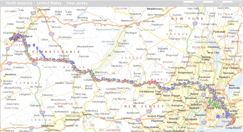 Click on the image to enlarge it. In May, CSI Wireless sent geomatics engineer Ronald Ramsaran to brief the ADA on GPS technology and help her put the case together. I asked Ramsaran how he became involved. "The rental vehicle had our product inside," he told me. "What [the prosecutor] needed was an expert witness from the hardware manufacturer to validate that all the information [from the GPS receiver] was correct and accurate. They also needed an expert on the performance of GPS and how it actually works. It was important that [the ADA] understand the technology, so that when she presented the case she presented accurate information." How does the Asset-Link transmit the GPS data? The device, Ramsaran told me, calculates a position update every second, logs the data locally every minute, and sends real-time tracking data every five minutes via Microburst to the GIS of the application service provider (ASP). Microburst, which transmits over the control channel of the Aeris cell phone network, is incorporated with a wide variety of ASPs. The prosecutor and Ramsaran used both the data transmitted over Microburst and that logged locally in the Asset-Link. "If there is any question [about the tracking data transmitted to the server] you go back to the data logger, which has a more dense set of data," Ramsaran explained to me. The data actually presented in court came from the data logger and was displayed on a map using Microsoft MapPoint. The DA's office kept custody of the unit throughout the investigation so that no one would be able to contaminate the evidence. "We also took the actual lat-long [coordinates] and used them as waypoints to re-navigate back to certain locations," Ramsaran told me. The data from the Asset-Link does not allow for post-processing but, according to Ramsaran, "the standalone accuracy of the GPS receiver within our product is about 5-10 meters." What was the main technical issue in court? It was the possibility that positions could be erroneous, Ramsaran told me. That is why he had to inform the DA's office as to how GPS actually works and of its track record. One key element in the case was that the murderer, after killing his victim, set her house on fire. The Asset-Link, which also monitors various sensors in the vehicle, showed that only one minute elapsed from the moment 911 received a call about the fire to the moment that the vehicle ignition was started.
Precision Locator Sprint Precision Locator enables dispatchers or supervisors to locate, map, and exchange text messages with resources in the field. It also allows them to set schedules and monitor when employees arrive at and leave certain locations, such as construction sites and warehouses. By replacing traditional radios with wireless phones running the application, companies can improve field communications and track the movements and whereabouts of employees without the need for additional GPS hardware. Sprint Precision Locator also provides password-protected access to a website that companies can use to locate each mobile device up to 1,000 times per month; determine whether a device is on or off up to 100 times per month; and send up to 50 SMS messages from the application to a mobile worker per month. For this application, Sprint Nextel partnered with Microsoft, which provided MapPoint Web Service, an open standards-based development platform for creating mapping and location-aware applications and services, and with WaveMarket, which provided tracking software. Garmin Mobile Based on Garmin's StreetPilot "c-series," Garmin Mobile enables users to navigate to an address anywhere in the United States and Puerto Rico, or search millions of points of interest (POIs), including airports, hotels, restaurants, banks, and ATMs. Users can also dial the POI's phone number automatically — for reservations, hours of operation, or other information. Once users choose a destination, Garmin Mobile calculates the fastest route to it, and provides voice-prompted, turn-by-turn directions along the way. The application's text-to-speech functionality allows the unit to audibly announce the name of upcoming streets. If users stray off course, it automatically calculates the quickest way to get back on track. Map data is provided by NAVTEQ. According to Garmin, the application is the first server-based navigation application that visually depicts and constantly updates the user's position on a detailed moving map. The user interface announces upcoming turns in text and arrow format. Users can also manage their destinations and personal locations online via the Garmin Mobile Manager website. Garmin Mobile is available on several Sprint handsets, including select Sprint PCS Multimedia Phones. TeleNav GPS Navigator Like in-car GPS navigation systems, TeleNav GPS Navigator displays maps and provides audible turn-by-turn directions and graphical driving cues to help drivers reach their desired destinations. Unlike in-vehicle systems, however, this application is portable and updates to road information are automatic. To use TeleNav, a customer specifies a destination via an interactive voice response (IVR) system or by keying in the address on the handset or device. The system then calculates a route and provides real-time directions over the mobile device. For trip planning, users can enter multiple destination addresses using TeleNav's website. The service also includes a Business Finder that can help users find nearby banks, restaurants, hotels, or other businesses. The service is available on Sprint's Sanyo 5600, 7400, and LG 535 mobile handsets as well as all GPS and Java-enabled handsets currently in the Nextel portfolio, including the new BlackBerry 7520. Sprint had previously launched a non-GPS text-based version of TeleNav GPS Navigator, and it was available to any phone subscribed to Vision service. However, according to a PR consultant for the company, "Customers are more interested in the real-time audio navigation service, which is much easier to follow and much safer to use in the car while driving." He added that "the TeleNav user interface has been enhanced for the CDMA handsets." MapQuest Find Me MapQuest Find Me enables users to find their location, access maps and directions, and locate nearby POI. It also allows them to share their location with other users and set up alerts to be notified when network members arrive or depart from a designated area. Sprint Nextel developed the service jointly with MapQuest and Research In Motion. Xypoint Location Services Xypoint Location Services (XLP) provides Sprint PCS subscribers with location technology capable of capturing the location of select handsets equipped with GPS chipsets. TCS also packages XLP with Assisted GPS (A-GPS) technology and a GIS platform and applications into a hosted solution it calls XLS. Supporting both Internet Protocol (IP)-based, handset-based and call-based network-initiated location access methods, XLS provides a single technology interface to deliver location-based services to Sprint PCS subscribers. On Tuesday, I discussed these Sprint Nextel offerings with Mary Foltz, the company's director of location-based services. She told me that since Nextel released the open application programming interface (API) for the Motorola iDEN phones, 40 companies have used it to develop applications — ranging from consumer turn-by-turn driving directions to business applications that track assets and manage time sheets. Roadside rescue was the first Sprint application, followed shortly by the business mobility framework, which has so far produced at least five applications certified and on the market. "We now have comparable services on both iDEN and Sprint." According to Foltz, Nextel launched its first LBS application in 2002 and Sprint its first one in 2003, but navigation is the first handset application available on both Sprint's CDMA network and Nextel's iDEN network. I asked her why this wave of LBS services is happening now, after being forecast for several years. She attributes it to a convergence of market forces and the success of the first, pioneering applications "Customers have seen the results and we are getting a wave of adoption." Commenting on the various companies with which Sprint Nextel has partnered for its location-based services, Foltz told me that "Mapquest does a terrific job of having a very accurate POI database." Whose geographic data does Sprint Nextel use? "We work with many different application providers," Foltz told me, "and each one is free to choose the data provider and GIS platform it wants." Both Sprint and Nextel, however, chose to use Java. I asked Foltz to describe the flow of data through the system. As part of the API, she told me, the network provides the handset's latitude, longitude, and time-stamp to the application developer. The developer then processes the customer's query on its server and returns the result — say, a set of directions — via the network to the handset, where it resides and is processed. For example, if the customer leaves the network's coverage area after receiving a set of directions, the handset uses the directions, in conjunction with its built-in GPS chipset, to provide turn-by-turn navigation. Before making an application available to its customers, Foltz told me, Sprint Nextel tests it extensively. "Then we take that application and post it for distribution on the network. The user can then select it from a menu on the handset and download it." Each time the user opens the application it displays a question: "Do you wish to grant privacy consent to this application?" The user can then choose whether to grant consent "just this once" or "for the duration of the session." Once the user grants consent the application begins to run. "We want to put the control in the customer's hands," Foltz says.
Briefly Noted The front page of the October 3 issue of the New York Times carried an article titled "Theft Case Rattles Sedate World of Rare Maps" by Alison Leigh Cowan. One sentence from the article summarizes it well: "A field marked by tweedy scholarship in quiet, climate-controlled vaults has been rattled by disclosures of maps disappearing amid lax security and suspicions that big money deals were being made with too few questions asked." It prompts the question, what is the geospatial community doing to promote better protection of rare maps? GEOSPATIAL RESPONSES TO HURRICANE KATRINA A new Web application, the Hurricane Katrina Disaster Viewer, is now available from ESRI to provide detailed information about areas impacted by Hurricane Katrina. The site allows the public, emergency responders, relief organizations, and others to locate an address or zoom to areas of interest and view areas declared "damaged" by FEMA, affected delivery areas for the U.S. Postal Service, post-disaster satellite imagery, population density, street maps, and much more information. Visitors can also generate reports about people, housing, and businesses in the affected areas. Deployed by ESRI using its ArcWeb Services technology and data products, the online mapping application was designed to provide continuously updated information to help users respond to the changing conditions of impacted areas. In addition to requesting and viewing maps online, visitors are able to access and download printable maps or digital displays that can be inserted into other documents, such as PowerPoint presentations. Visitors can also customize maps with the types of information they would like to see or by adding their own points of interest. The data presented in the viewer is provided directly by public and commercial organizations such as FEMA and the U.S. Postal Service. ESRI would like to extend special thanks to GlobeXplorer, Tele Atlas, and Meteorlogix for the data they provided. CONTRACTS & COLLABORATIONS The Seneca County, Ohio, auditor has selected Digital Data Technologies, Inc. (DDTI) for website development, hosting, and maintenance. The new website features real property data, real estate tax information, colorized property sketches, property record cards, and GIS information. DDTI provides government and real estate data warehousing solutions on the Internet. The company combines hardware, software, and hosting service, including the scheduling of daily data updates and GIS mapping customization. Intermap Federal Services Inc., a subsidiary of Intermap Technologies Corp., has been awarded a new data acquisition contract in the amount of $3.7 million. The company declined to identify the client. The contract is for delivery of Intermap's high-resolution digital elevation data and radar imagery. The company has two aircraft deployed onsite and data collection for the project is already underway. Campbell County, Virginia has selected Timmons Group, a geospatial and engineering services company, to support its application programming and information technology architecture. The project will enhance the county's existing GIS capabilities by exposing Internet and Intranet portals to their constituent base, both internal county departments and county residents. The solution will be built on ESRI's ArcSDE and ArcIMS and will leverage Timmons Group's custom .NET ArcIMS API. Mapping portals will allow for control of users through assigning roles and will expose data and attributes based on authentication roles. Geospatial decision support (GDS) capabilities will be provided by linking other, non-spatial databases, to spatial features for exposure through established portals. All developed portals will be built on a common framework and will access common geospatial repositories to ease administration overhead. Timmons Group worked closely with Campbell County's Information Technology staff to develop an information technology systems and security architecture that will maximize data security, portal mapping performance and, ultimately, end-user experience. PRODUCTS Applanix has released its new POSTrack system designed for streamlined airborne direct georeferencing and in-flight task automation. The new system combines the latest integrated Inertial/GPS technology from Applanix with the Flight Management System (FMS) expertise of Track'air B.V. in The Netherlands. Designed to reduce the operational costs and workload associated with the preparation and implementation of airborne surveys, POSTrack streamlines pre-flight mission planning and in-flight tasks. In addition to handling the GPS/IMU functions, POSTrack has been configured to automatically control and trigger various airborne sensors, to enable precise flight path guidance and accurate sensor positioning. This translates into optimized airtime over the target area and the most economical and efficient mission capability. The real-time orientation solution generated by the system can be applied to stabilized mounts, such as the Somag GSM3000 and Leica PAV30, thereby improving performance for automatic drift correction and leveling control. POSTrack is comprised of a single-mount, twin module incorporating the POS AV computer system (PCS) and FMS computer system (FCS) using real-time embedded computing technology. Control of system is via a ruggedized touch screen pilot display for pilot-only operation, or via a remote operator interface. This week Trimble introduced the GeoXH handheld receiver — the first integrated GPS field computer to deliver post-processed subfoot (30 cm) accuracy for GIS data collection and mapping. With the addition of an external Zephyr antenna, users can attain eight-inch (20 cm) postprocessed accuracy. The company made the announcement at INTERGEO, the world's largest conference and trade fair for geodesy, geoinformation, and land management, in Duesseldorf, Germany. It expects to begin shipping the devices at the end of October. The GeoXH is based on Trimble's H-Star technology, first introduced in the GPS Pathfinder ProXH receiver earlier this year. The H-Star handhelds and receivers greatly reduce the time it takes to collect high accuracy GPS data in the field. The GeoXH is an all-in-one cable-free solution. It consists of a GPS receiver inside a rugged handheld computer and is designed to deliver the accuracy required by electric and gas utilities, water/wastewater services, land reform projects, and other applications where positioning is crucial. In recent years, these sectors have experienced increased requirements for accuracy that could only be addressed by long location occupation times or the use of survey grade systems that deliver a much higher accuracy than needed. The GeoXH handheld is part of the new GeoExplorer 2005 series that includes the submeter GeoXT and the 1-3 meter GeoXM handhelds. All three feature a 416MHz processor running Microsoft Windows Mobile 5.0 software for Pocket PC, rechargeable battery for all day use, 512MB of onboard memory, expandable Secure Digital (SD) memory, and Bluetooth and WiFi connectivity as standard. Leica Geosystems has introduced the Leica Builder series, an easy-to-operate theodolite intended to accelerate common construction site jobs, such as stake-out or plumbing. The three models - Builder T, Builder R, and Builder RM - are based on the same software and have the similar user interfaces, thereby making it easy to switch from one model to the other. The Builder T features a laser plummet, an endless drive, and a large display. The Builder R's focussed visible red laser and flat prism enable measurements of up to 250 meters. Together with an angle measurement, every point can be determined in reference to a line as well as in height with a single measurement — without having to reconfigure the Builder. The Builder RM can also contain a digital construction plan: on the construction site construction data can be called up, measurements can be saved, and the information can be directly transferred to a PC for editing. This eliminates mistakes in reading and writing. WhiteStar Corp. marked its 15th anniversary this week by launching a new geospatial data bundling service for users of ESRI ArcSDE software. The service enables clients to tap into the WhiteStar archive of land survey and petroleum-related information, integrate these geospatial files with their own, and make the entire data set accessible across their corporate enterprise via ArcSDE. As part of the offering, clients can select data products from WhiteStar's National Pipeline Database (containing location and attribute details for oil, gas and petroleum-product pipelines across the entire United States), National Public Lands Survey (a digital 1:24,000 land base derived from the USGS topographic map series), and National Well Location File (location and attribute information for all oil, gas coal-bed methane well heads in the United States, including production records, operator name, and API number). WhiteStar technicians then load the data sets into ArcSDE using customized techniques to configure file parameters, feature classes and schemas to ensure the new data integrates with the client's existing geospatial data. Clients may purchase data sets in their entirety or by the state, county, or single feature segment. WhiteStar has normalized each data set to eliminate variations in file formatting caused by record-input disparities at the government level. Other data sets will be added to the data bundling services as they become available. AlphaPixel, LLChas released version 1.0 of their third product, PixelSense 742. It is a tool for processing Landsat 742 band combination remote-sensed imagery into natural-color georeferenced GeoTIFF images, ready to use in any mainstream GIS or visualization software. The product allows users to access the vast quantities of commonly-available high-resolution Landsat image mosaics (GeoCover, etc.) available online today that were previously unusable due to their unconventional color balance. PixelSense 742 offers multi-file batch processing via command-line or user-interface, instantly processing large amounts of Landsat 7/4/2 band imagery. AlphaPixel leverages the strengths of the Internet to deliver streamlined and cost-effective sales, service, and support. Applanix has launched its next generation Digital Sensor System, the DSS 322. The new system incorporates a 22 megapixel CCD array, Aerolens custom-manufactured optics, and TruSpectrum technology engineered to maximize the system's capability in generating high-quality color and CIR (color infrared ) digital geospatial imaging products. The DSS 322 is a modular, turnkey digital airborne remote sensing system designed to complete all phases of a project life cycle, from initial flight planning, through digital image acquisition to final product output. The system includes a new camera data module and computer firmware, plus enhanced Flight Management software. The system's new lenses have been specifically designed for Applanix by Carl Zeiss, and are among the first commercial medium-format lenses manufactured solely for airborne applications. They feature a fixed focus and fixed aperture, together with a customized camera adapter that ensures repeatability and stability of calibration. As well as incorporating the custom-made optics, the DSS 322 also features the new Applanix TruSpectrum technology, which produces improved color radiometric accuracy, a very important attribute for image interpretation tasks. CONFERENCES The first Government Open Source Conference (GOSCON) will take place October 13-14 in Portland, Oregon, at the University Place Hotel. The conference is sponsored by Oregon State University's Open Source Lab (OSU OSL) and aims to meet the growing need for information and best practices regarding open source software in government settings. Key topics at the event include open source software case studies, return on investment, implementation, and security. According to Scott Kveton, OSU OSL's associate director, the event was first conceived to serve Oregon's public sector IT managers, then grew into a national conference. OSU OSL hosts the world's largest open source projects. "Open source" refers to software developed for free distribution with its source code available for study, changes, and improvements by other software developers. According to a listing in "Wikipedia," an online encyclopedia created with open source software, "Open source software generally allows anybody to make a new version of the software, port it to new operating systems and processor architectures, share it with others, or market it. The advantage of open source is to let the product be more understandable, modifiable, duplicatable, or simply accessible, while still very marketable." GOSCON will feature a broad range of expert speakers and panelists from industry, government, academia, and non-profit settings — including Linda Hamel, general counsel of the Information Technology Division of the Commonwealth of Massachusetts; Dan Frye, vice president of Linux Technology for IBM; Timothy Ney, executive director of the GNOME Foundation and its open sourcedesktop project; and Terry Bollinger of Mitre. The conference registration fee is $150. Registration is open until October 11. EDUCATION & TRAINING A new free, live training seminar from ESRI Virtual Campus focuses on customizing and extending ArcGIS Desktop and building new applications with ArcGIS Engine and ArcGIS Server. Introduction to ArcGIS for Developers will be presented on October 20, at 9:00 a.m., 11:00 a.m., and 3:00 p.m., Pacific time. ArcGIS is composed of professional GIS applications and GIS servers that developers can customize and extend. Java and .NET developers can use the ArcGIS developer kits to spatially enable existing enterprise applications or build custom mapping and geospatial applications. Introduction to ArcGIS for Developers reveals developer resources and opportunities within the ESRI Developer Network. The presenter will discuss the ArcGIS developer framework, customizing and extending ArcGIS Desktop applications, custom applications with ArcGIS Engine, and ArcGIS Server Web applications. A broadband Internet connection and an ESRI Virtual Campus membership are required to view the seminar. Becoming a Virtual Campus member is free and only takes a few minutes. Following the live presentation, the seminar will be archived and available for viewing at any time on the Virtual Campus Web site. In observance of GIS Day, November 16, the Mid-Atlantic Chapter of the Urban and Regional Information Systems Association (MAC URISA) will be hosting a booth at the Fifth Annual NBC10 Technology and Lifestyles Expo at the Fort Washington Expo Center in Fort Washington, Pennsylvania. The booth will be open on November 12 and 13, from 10:00 to 5:00. It will highlight the efforts of the regional GIS community by showcasing many examples of GIS and mapping technology. The Expo is a show for consumers interested in expanding their knowledge base of finance, personal safety, careers, education, travel, communications, technology, and home owning. This free public event is designed to capture the attention of tens of thousands of consumers. Last year's MAC-URISA booth was one of the most popular attractions throughout the weekend, as presenters from all over the Mid-Atlantic region showcased many new and exciting applications featuring GIS technology. This year the organization expects to see more than 25,000 people, from the Philadelphia and Delaware Valley areas. In order to make this year's MAC-URISA contribution meaningful and successful, the organization invites GIS professionals from throughout the region to present new software, applications, techniques, or ideas. To be considered, submit a short description of a 20-30 minute presentation for review, by Friday, October 28, to Seth Hackman, MAC-URISA Trustee, at [email protected] OTHER Leica Geosystems has launched a new program for the academic and research community to facilitate the introduction of GPS reference station network technology into their teaching curriculum and scientific research activities. The Affordable Technology for Higher-Education and Non-profit Associations (ATHENA) program is designed to make it easier for universities, colleges, research organizations, and members of the University NAVSTAR Consortium (UNAVCO) to acquire GPS reference station technology. It provides a formalized discounted purchasing mechanism for bundled packages of GPS reference station hardware and software, including comprehensive training and technical support. Specific discounted packages consist of various GPS reference station hardware and processing software options. These options include the new Leica GRX1200 Pro reference station sensor, Leica AT504 choke ring antenna, AX1202 geodetic antenna, and educational licenses of the Leica GPS Spider 2.0 reference station networking software. Under the ATHENA program, Leica Geosystems is also offering packages enabling users to acquire regular updates of the latest firmware and software features. Maintenance support and extended warranties are also available. All hardware products feature Leica Geosystems' SmartTrack technology, which delivers dual-frequency code and phase measurements at rates up to 20 Hz. The Leica GPS Spider 2.0 software licenses reflect a client/server solution for control and configuration of GPS reference station sensors over various communication media, including the automated provision of real-time correction and datafile products. Institutions participating in ATHENA will obtain all client/server functionality, allowing more students to have access to advanced reference station software to pursue individualized research. ESRI Press has published Spatial Portals: Gateways to Geographic Information, by Dr. Winnie Tang and Jan Selwood. The book explores the opportunities, developments, challenges, and issues that are impacting the geospatial industry and focuses on how spatial portals are revolutionizing the way we find, manage, and share geographic knowledge. These websites distribute and collect geographic data and mapping services maintained anywhere on the Internet and GIS users increasingly depend on them to access and share spatial information. Spatial Portals explains and reviews this rapidly evolving technology for students, public officials, business leaders, and other decision makers from the perspective of a GIS user. From the world's response to the Indian Ocean tsunami of 2004 to the management of waters in the Canadian Pacific, readers experience real-world examples of how organizations around the world construct and use spatial portals. Tang is CEO of ESRI China and is widely recognized as a leader of the Asian GIS industry. She regularly lectures at universities in the region and serves as an advisor to a wide variety of geographic, technology, and conservation organizations in Asia. Selwood is an independent GIS consultant based in Japan who works extensively in Europe and Asia developing and managing GIS projects for a wide range of clients and applications.
Matteo Luccio, Editor GIS Monitor Ultimate Map/GIS Directory — Your search is over! GIS Monitor is published by: GITC America, Inc.
|

|
part, without prior authorization from GITC America, Inc. GIS Monitor is a GITC publication. |