Letters, Points of Interest, Kudos and Conundrums, Week in Review (Announcements, Contracts, Products, Events, Training, People) Back Issues, Advertise, Contact, Subscribe/Unsubscribe If, for some reason you cannot read this document, visit: http://www.gismonitor.com/news/newsletter/archive/111804.php
And, as always, thanks for your continued support of this publication. Adena
Another GIS Day
I didn't hear about Geography Awareness Week this year until I happened upon a National Public Radio piece on the topic. The theme for Geography Awareness Week is "Cultures: The Sound of Place." National Geographic (NGS) has had kids map sounds of their communities. While I heard some "moo cows" many of the sounds were man-made. NGS is making a soundscape map that'll be put on display at its headquarters. A quick search of Internet-based news on Wednesday turned up 21 articles mentioning GAW. Three references were in GIS company press releases posted to GIS websites. As I noted in years past, Geography Awareness Week doesn't seem to have the energy that I recall from its early days. Of course, in its early days, I was in a graduate department of geography. Compare the GAW number (21) to the number of hits, again in the Internet-based news, for GIS Day: 80. Of those, a quick count puts 48 on GIS websites. So, on the non-geo websites, the score is 19 for GAW and 32 for GIS Day. Some appear twice since they mention both. Granted these data are not scientific, but clearly GIS Day is getting out beyond our borders, which pleases me. Some other interesting findings: According to one source (not the Commonwealth), Pennsylvania hosted "Geospatial Information Systems Day." Many events were held the week before the official GIS Day, November 17; Pennsylvania's was November 9th. That allowed event holders and participants to perhaps hit more than one event. As in years past, different civic leaders proclaimed GIS Day in their jurisdictions. One was the city of City of Ottawa, Canada. Officials in Canada announced Government of Canada funding for technology projects in the geomatics industry on GIS Day. As we go to press I found that four companies were given funding, but could not find their names. I found fewer references to ESRI in discussions of GIS Day. While listed as an overall sponsor, and the sponsor of specific events, the link between the event and the company is waning. That may mean many things, but I hope one is that the event is standing more on its own inertia than ESRI's good graces. While in past years other GIS vendors were active, I didn't find any references to their efforts this year.

Purple Map Fame. Reader Atanas notes that the state "purple map" fellow, Jeff Culver, is branching out. Now you can get his map on T-shirts, mugs, etc. If you want the county one by Robert J. Vanderbei (see below), visit here. (I have no relationship to CafePress, but have used their services for sports clubs in the past.) Michigan Map. I was surprised how well-distributed the Michigan cartograms article, "Maps And Cartograms Of The 2004 US Presidential Election Results" was. I found it referenced in an article (free registration required) in the Washington Post, got e-mails from my non-geo friends about it, and even got e-mails noting it from GIS Monitor readers who missed it in last week's issue. I wonder if this article raised more awareness about cartography than the election maps on TV.
More Cartograms. Longtime reader Jim Bash sent on some other cartogram websites. BBC Rules. Robert Harmon, GISP from Salem, Oregon pointed to one more mapping site of note. "Leave it to the Brits to produce a very nice web map of our election (see "Past elections" and "Electoral college" tabs in particular)."

� But first, Lynda Wayne GISP, the President of the GISCI Board of Directors, sent in this clarification. "I'd like to clarify the GISCI Letter of Invite you commented upon in your November 11, 2004 edition of GIS Monitor. As stated in the letter, the mission of the GISCI is to establish credentials for the profession, instill a code of ethics, and serve as a voice for the GIS community. The primary purpose in asking you, and other established GIS professionals, to become certified was to seek your active participation in promoting those credentials, instilling the code of ethics, and to lend your experience and knowledge in directing our professional voice. The reference within the letter of invite to 'symbolic participation' was an ill attempt to recognize that while industry leaders are not in need of another acronym after their name, their participation increases the visibility of GIS as a profession. In retrospect, we should have used words similar to your own and better promoted GIS Certification to you as a 'real act that would help grow both yourself and your chosen profession.'" � Bryan Baker of Apple Valley, CA wrote: "I strongly agree with your skepticism about the current GIS certification programs. The GISCI certification in particular is too broad and vague to have useful meaning to employers. Certification can come by occupying a GIS position of some description for several years, and/or by taking coursework in GIS, and/or by attending conferences, and/or by a variety of professional activities including papers in proceedings and membership in an organization. What can an employer really conclude about a person's abilities by looking at the certification title on the resume? Very little indeed. The employer would only ascertain needed information by prying into the candidate's actual qualifications--which is what the employer should do in any case, with or without the certification on the resume. "The danger is that such certifications will become a winnowing mechanism for employers, who will put 'certified' candidates into one file and 'non-certified' candidates into another (probably circular). The damage will be both to the candidates and to the employer. If it comes to the point where this kind of certification becomes a clear asset for employment, then everyone will get the relatively easy-to-obtain certification (at least those with $250 inflation-adjusted dollars), and the certification will simply be a hurdle in front of prospective GIS professionals. Certifications, if they are to be truly useful, should be both specific in scope and relatively difficult to obtain." � Ralph Grabowski from British Columbia, Canada gave his perspective on certification in the context of health professions. "This even extends to university degrees. Back in the late 1970s, my wife became a registered nurse after 2.5 years of working at a university hospital; no degree, but also no cost, because she worked in the hospital as she took the courses. "About ten years ago, the nurses association decided that all registered nurses needed to have a Bachelors degree. So now the nurses have to pay for four years at university, receive far less practical training, and take nearly twice as long to enter the workforce. "A friend is a prof at UBC (University of British Columbia), and has the job of creating the masters program for physiotherapy. She says that the physio association now requires a Masters degree for its members. She says it's nuts: the physiotherapists are no better at their jobs, and this is just a cash grab by the University. "I feel sorry for nurses, who pay for one or more degrees, pay dues to a professional association, and pay union dues -- and then burn out in a few years. Cash grab, cash grab, cash grab!" � Peter Batty of TenSails, who has written about certification in the past (here and here, for example), shared his thoughts and also pointed readers to Rebecca Somers' article. "I just wanted to applaud your decision not to become a GISP. It is easy to be flattered by such an invitation and accept it without thinking, but this would lend credibility to a program which in my opinion does not deserve it. As you know I've been outspoken against this program and I continue to believe that it is misguided. Rebecca Somers' article which you referenced gives a good summary of the significant issues which exist in all the areas where certification is claimed to have merit." � Michael Gould a professor at University Jaume I in Castell�n, Spain looked at certification in the context of higher academic degrees. "I read with interest your interpretation of the offer to become a certified GISP. "This reminds me of a comment a senior member of the GIS community made to me back in 2001: 'I've never met a Ph.D... who didn't need one.' (He was joking of course, as he knows me and knows that I, like most Ph.D.s, got mine not for status but rather because it is the minimum requirement for getting a job in academia.) "But similarly I wonder, what GIS professional worth his/her salt would need one of these certificates?" � Jim Bash added one element that I neglected. "I thought it was interesting that you didn't mention the cost of GIS certification. I don't see its value to me and especially not when it costs $$s." � An anonymous reader got right to the point. "You are right on target with your certification analysis. Bunch of crap; it's like paying $50 to get into the Who's Who book of X..." � Robert Ball, Senior Planner at Kern Council of Governments in Bakersfield, CA offered "an argument for becoming GIS Certified." "The GIS Certification Institute (GISCI) GIS Professionals (GISP) Certification is a step in the right direction toward bringing unity to the fractured GIS community landscape. "Each scale generates its own set of meetings and conferences, often competing for a limited pool of members, volunteers, attendees, and sponsors -- not to mention the internal agency committees we participate on as part of our regular jobs." "Although not a goal of the Institute, it has the potential to become an overarching confederacy or congress for the core GIS professional associations, much as ACSM has done for the land surveying associations." "We must send a message to our association officers to stop operating with their blinders on. One way to do this would be for individual members of all the core GIS professional organizations to become GISPs and encourage their association to support the Institute." � Jeff Owen of Geo-Aid Limited in the UK wanted to respond to Clifford Mugnier's response regarding a single grid. "While I'll agree to most of the points raised by Clifford J. Mugnier regarding the concept of a single grid system, I will take up one issue with him. Clifford refers to 1:24,000 mapping as being 'large scale.' Perhaps to you Americans this is true, but we Europeans tend to think scales of between 1:1,000 1:5,000 as being of large scale. At these scales small datum changes really count over big distances, and are perhaps the biggest obstacle to a single grid. The idea is great for the military, who have yet an even different view on what 'precision' means." � Finally, a reader wrote a note that alternately saddened and pleased me. "� if not for reading the GIS Monitor I would have probably never known of his [Herman Kahrs'] passing."

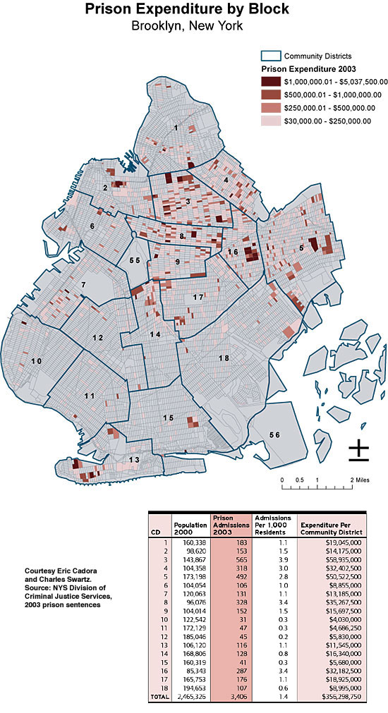
Points of Interest GPS for Skiing Competition? Mountain Stats has a new website for the collection of on-mountain performance data. The app takes the raw data from handheld GPS units and gives the skier or boarder a complete break down of their day on the mountain. For every run, the rider will see their vertical tackled, distance covered, degree of slope, and, says the marketing material "most importantly, top and average speed." To go one step further, with the data, individual skiers and snowboarders can compete against one another for prizes. Futurist on Tagged Locations. Howard Rheingold (SmartMobs) wrote up his experience with a location-tagging app demonstrated at a recent Institute for the Future event. The article explains the challenges he and others faced with the implementation, but also looks at the implications and challenges to the concept in general. It's nice to see this "deeper" look at our domain by one of the future thinkers. Long Distance Hug. Researchers at Carnegie Mellon have developed a "pillow" of sorts that can be a long distance equivalent of a hug (free registration required) for Grandma. The child might start the communication which "calls" the pillow at Grandma's from a local pillow. The called pillow flashes and makes sounds announcing basically, a "hug is coming," then the child can squeeze or pat the local pillow. Sensors pick up the motion and send them on to Grandma's pillow which vibrates and warms up. And, don't worry, you can "leave a hug message" if Grandma is not home to immediately receive the hug. Autodesk Touts DWF. Last week I noted that Cyon Research had made a new PDF available, one funded by Adobe, which argues that PDF is a good tool for sharing AEC information. Adobe has announced a new version of the Acrobat Suite this week that will be due out by year-end. The best new thing: free "markup" in the Reader for documents that are tagged for markup. There are also enhancements for AEC (recall that Bentley was working with Adobe on those) and 3D visualization. (More on the latter from Ralph Grabowski here.) Last Friday I got an e-mail from Tony Peach, Director, Product Marketing, Autodesk Collaboration Services (the "head" DWF person) at Autodesk. He outlined a few reasons that PDF is not a good choice and that DWF is better. 1) PDF is 2D. DWF, like the world is 3D. Search Wars. Microsoft offered up a new search engine last week. It's ok, but most reviews suggest it's not time to dump Google just yet. The news over at Google is that its local search can now be used via phone. Send a key word and ZIP code to Google and you get back location specific answers. A newcomer to search fray, UpSnap, is a search engine specifically written for texting, which includes location support. For example, instead of using a ZIP code to call a cab, using UpSnap you key in the airport code and "taxi." UpSnap signed with LookSmart, a pay for placement search engine, to deliver results. And, get this, UpSnap offers results that can contain coupons, offers, or even the option for a merchant to call the caller immediately (sort of "opt-in" location-based advertising). Up in Canada, Bell Canada hosts MapMe powered by WaveMarket. It's been out for several months. How's it doing? "WaveMarket CEO Tasso Roumeliotis says MapMe is one of the most popular software downloads for Bell Mobility customers." Next up for WaveMarket is Crunkie (yes, that's a wretched name, reminds me of Chuckie from those awful slasher movies) a friend finder social network app. The End of The Knowledge? If you hang out in London enough you'll see them: young people on scooters with maps. They are not tourists, but aspiring taxi drivers. To become a driver, one must pass a test on "The Knowledge," that is, know the city inside and out. (And, it works. I've yet to get a taxi in London that doesn't know how to get where I want to go.) But, with GPS and navigation systems, whither The Knowledge? Cabbies of course hate the idea of technology taking away their advantage. But licensing authorities are looking at a "water down" test for 2006. They feel that as navigation systems get better, the whole taxi system may change, encouraging more taxis in a crowded market. Intermap Results. NEXTMap data licensing sales partially offset the decline in fee-for-service revenue for Intermap. The company says that demonstrates the strength in the data license resale model. Revenues for the third quarter ended September 30, 2004, were $6.2 million as compared to revenues of $9.5 million for the comparable quarter ended September 30, 2003. Intermap reported a net loss in the third quarter of $870 thousand, or ($0.06) per share, as compared to net income of $448 thousand, or $0.04 per share in the third quarter of 2003. There's no mention of the AirPhotoUSA non-acquisition. That deal was not made in time for the set deadline and AirPhotoUSA decided not to extend the date. Thumbs Up for GIS in Secondary Ed. A report from the lead agency for UK education finds that GIS is valuable in secondary education. By making mapping concepts easier, GIS allows students to concentrate on "interpreting and analyzing" data. The report cites another benefit that seems to focus on speed: "GIS comes into its own in mapmaking, providing a facility that would often take days to produce manually." Web Mapping Not Ubiquitous. A survey of cities and counties conducted by the International City/County Management Association (ICMA) revealed interesting stats on Web mapping. "Less than 30 percent of respondents accept online requests for local government records or services (such as pothole repair), provide GIS/mapping data, or send electronic newsletters to residents and businesses, but 50 to 62 percent of those respondents plan to provide these services in the future." More than 3,400 cities and counties (42 percent) responded to the survey. Aggregate results are available online (pdf) and the complete dataset is available for sale. Student Tracking Bugs. I've written before about technology to track students comings and goings onto and out of school buses. While most articles highlight how the technology works and potential glitches (like children trading IDs), a recent New York Times (free registration required) article goes further: it details the bugs. These include: "no record that any of the students on the bus had arrived," "double entries for some students, and [wrong] arrival times and addresses," and "kiosks [that] failed to register some students, or registered ones who were not there." Map Prison Costs. The Village Voice hosts a map by Eric Cadora and Charles Swartz which "illustrates the estimated cost per block for people who entered the state prison system in 2003." That's right, the cost is mapped to the person's home address. It's pretty interesting. Futures. An article in PC Week takes a look at future trends. Of interest to the geosavvy: "Future cameras, equipped with GPS chips, will go further. 'I could see a cell phone's camera putting in the GPS coordinates of an image, and software that automatically recognizes that the shot is in Paris,' says Tapan Bhat, director of product management for Adobe's Consumer Digital Imaging and Digital Video Products division. He predicts such technology could surface in 2007." "In 2005, cell phones will become the largest user of GPS chips of any device. Integrated GPS chips already let some mobile phone users check their handset for directions, but users can expect more location-based services--and, alas, advertising." Should Locating for E-911 Be Mandated? No, says U.S.-based TruePosition. The statement was made as a warning to the European Commission suggesting that body not follow the approach in the U.S. Jason Angelides, director of global services at TruePosition explains, "The critical mistake was when it created a mandate and forced wireless operators to do something they hadn't even thought about." That, he concludes, put carriers on the defensive, caused legal action, and ultimately delayed implementation. There's a white paper available on the topic.
Kudos and Conundrums Kudos (concepts we applaud) Open Records Support GIS Data Delivery. The New Jersey Open Public Records Act was upheld (free registration required) in West Milford to allow a resident to receive a copy of township GIS data without filling out forms. The requestor, Ross Kushner, the director of the Pequannock River Coalition asked for the data in June. He was asked to wait until, in September, he was asked to fill out forms for the request. Filling out those forms, said the ruling is not mandated by the Act.Conundrums (concepts we question/give us pause) LBS Phones in, Ham Out? It seems that this year, for the first time in some 30 years, amateur Ham Radio operators will not be aiding in the management of the Tournament of Roses Parade. Instead, Nextel has donated phones and service. The Tournament of Roses Radio Amateurs pulled out of discussions last week. Hams suggest that cell phone signals often are weak in places where their radios work. Parade officials feel that with phones, its workers don't require radio operators to "shadow" them. In comments posted on a ham website, many operators feel that such events give them important practice to prepare for emergencies such as 9/11 and the recent hurricanes in Florida. Hams typically volunteer both their time and equipment. I can speak from experience, working at road races that we found having one communications center for each position (water stop, medical tent, etc.) kept things running smoothly. And we loved the idea of having a dedicated person worrying about communications so we could do our jobs. And, the hams I've worked with were nothing but professional.
Please note: Material used herein is often supplied by external sources and used as is. � Announcements MapInfo Corporation announced it has donated its location-based software and data to Siena College for use in the School of Business marketing and management courses. NAC Geographic Products Inc. has announced that Australia, Greece, and Slovakia have been added to the countries digitized with Universal Addresses and Natural Area Codes, and made the number of the Universal Address digitized countries to 22. Vancouver-based GIS & drafting consultancy Charone has been chosen as the recipient of the 2004 Autodesk Innovation Award for the Infrastructure Solutions Division's (ISD) Customer Innovation Award. The award is for Rapid Environmental Modeling (REM) System, an "intelligent 3D Geospatial Modeling System, capable of producing high quality 3D visuals based on analysis or queries run from databases or on the entities themselves." The award will be presented at Autodesk University in December. Dr. Kenneth Owens, Jr., and Paul Burgess of Humboldt State University received the Intel Environment Award for developing remote-controlled, GPS-enabled robots to seek and destroy landmines. The Open Geospatial Consortium Inc. (OGC) has published a Request for Information (RFI) to solicit input on technologies related to Contextual State Descriptions (CSD). A CSD describes the "environment" or context in which a service chain executes. DigitalGlobe announced its partnership with Bird's Eye Images to market and sell high-quality art prints of satellite imagery collected by QuickBird, the world's highest resolution imaging satellite. Sanborn will sell its San Antonio office to Tri-State Consulting Services, Inc. The borough of Fairbanks, Alaska presented an award for the use of its GIS to better plan for contingencies during this summer's Boundary Fire. ORBIMAGE announced third quarter revenues. Total revenues for the third quarter of 2004 were $8.9 million versus third quarter 2003 revenues of $1.1 million. Net loss for the third quarter of 2004 was $6.1 million versus a loss of $4.6 million in the same period a year ago. Total revenues for the nine months ended September 30, 2004 were $20.7 million versus $4.1 million in the same 2003 period. Net loss for the first nine months of 2004 was $19.0 million versus a loss of $10.4 million in the same period a year ago. Total revenues in the 2004 periods reflect the commencement of OrbView-3 operations, while net loss in the 2004 periods reflects an increase in operating costs (including depreciation) resulting from the OrbView-3 satellite and from interest expense on our Senior Notes and Senior Subordinated Notes issued on December 31, 2003. "We made a conscious decision to sacrifice some short-term operating growth in order to focus our efforts to win the National Geospatial- Intelligence Agency's (NGA) NextView Second Vendor Program satellite procurement," said ORBIMAGE President and Chief Executive Officer Matthew O'Connell. � Contracts and Sales Civil Solutions announced that it was awarded a GIS parcel mapping services contract by the Camden County Improvement Authority (CCIA) of Cherry Hill, NJ. The project will begin immediately and is scheduled to be completed in fourteen months. Frederick County, Virginia, Euless Texas, Brazos County, Texas, Mesquite, Texas, and Whitfield County, Georgia are some of the local governments that have purchased Freeance, an ArcIMS rapid development application builder, in the past 60 days. PlanGraphics, Inc. has been awarded a grant to develop an Internet-enabled emergency response system for the Kentucky Chemical Stockpile Preparedness Program (CSEPP) by the Kentucky Science & Engineering Foundation and the Public Safety and Security Institute for Technology at Eastern Kentucky University's Justice and Safety Center. Officials at the EPA's Region 5 Superfund Division Field Environmental Decision Support announced that they chose Oracle Database 10g and 10g Spatial software for a geospatial database for first responders. A rather confusing discussion in Federal Computer Week included these statements: "The geographic information database can be accessed via a USB plug-in" and "the process is like typing on a typewriter, since it uses a standard Java interface." Huh? Pictometry International Corp. has secured a license agreement for Elmore County, AL for providing software and imagery. � Products MapText, Inc. released Label-Web 1.0, a high-quality text placement engine that labels Web-based maps on the fly in a GeoMedia WebMap 5.2 environment. CustomWeather, Inc. has partnered with Weather Decision Technologies, Inc. and TOA Systems, Inc. to offer access to real-time lightning strike information for the continental United States, southern Canada, Mexico, and Central America through the United States Precision Lightning Network (USPLN). The lightning information has been made available in an OpenGIS-based environment; it is alternatively available as a lightning detection data stream. SIA supplies Geographic Information System solutions based on its own dataMAP GIS product portfolio. dataMAP GIS is a powerful business tool for geographically visualizing, managing, and analyzing both client and demographic information, superimposed on a backdrop of computerized mapping from a range of digital map suppliers. SIA's CATmap system applies powerful GIS technology to help you in sales tracking and analysis, customer profiling, and planning effective marketing campaigns. ESRI announced that ArcGIS Business Analyst desktop software with enhanced functionality and a rich variety of data is now available for the ArcGIS 9 platform. manifold.net announced that Manifold System Release 6.00 has been enhanced with more than 320 new features in the latest Manifold Service Pack (SP). A major new feature is the ability to operate as an Open Geospatial Consortium (OGC) WMS Server. OpenOSX announced that GRASS 5.4.0 along with an optional installation of the experimental GRASS 5.7.0 - a preview of GRASS 5.1 is available. In addition to enhanced stability, the new release offers datum transformations, new graphical user interface (GUI), improved 3D visualization, LiDAR tools, 3D raster vortex tools, MATLAB import and export, 24-bit color and much more. The optional GRASS 5.7 includes a new Display Manager, symbol support, charting, easy printing, POV-Ray support offering ray tracing and radiosity rendering, and more. EmerGeo Solutions Inc. announced additional mapping tools to enhance preparedness and response capabilities. The new version adds chemical dispersion models to EmerGeo's natural hazard models to support all-hazard planning and response. Digital Map Products (DMP), a developer of Internet-hosted mapping applications, announced a new version of its flagship product. The new version, CityGIS5, is a Web-hosted solution for enterprise-wide deployment of an organization's maps and data. INPHO GmbH, Stuttgart, Germany, has launched DTMaster software for quality assurance of large DTM projects created e.g., by LiDAR systems or MATCH-T software. MapInfo announced MapInfo MapMarker v2.0, a new UK address cleaning and geocoding solution designed specifically to work with UK address data. � Events The call for papers for the 2nd International Workshop on Geographic Information Management (GIM '05) to be held in conjunction with DEXA'05 and EGOV'05 is online. The events are scheduled for August 22-26, 2005 in Copenhagen, Denmark. Definiens Imaging will host its 4th International User Meeting for all eCognition customers in Baltimore, Maryland, March 5-6, 2005. � Training ESRI released a statement this week saying, "ESRI training courses now earn participants educational achievement points from the GIS Certification Institute (GISCI)." I contacted ESRI since I believed the classes were always valid for points. That's the case. ESRI confirmed: "We are simply pointing this out to users who may not have been aware" and noted one improvement: "One improvement that we have made on our end recently is that we are now printing the number of hours of instruction for our Virtual Campus training certificates." � People
R.A. Smith & Associates, Inc. has hired David Haines as GIS project manager. Haines has eight years of experience in GIS and was previously employed at the city of New Berlin, Wisconsin as planning services manager. Ten Sails Consulting, a GE Smallworld GIS development and services company, announced Deb Miller and Thomas Welsh have joined the company. Both bring extensive experience with PowerOn, a Smallworld GIS-based application used by utilities for outage management, service dispatch, and system troubleshooting.
Advertise With Us
Contact GIS Monitor is published by: GITC America, Inc.
Subscribe/Unsubscribe |