Letters, Points of Interest, Week in Review, Back Issues, Advertise, Contact, Subscribe/Unsubscribe
INTERGRAPH'S UTILITIES & COMMUNICATIONS GROUP MOVES TO A NEW HOME I spoke with Bart Hoogenraad, Intergraph's Global Marketing Director based in the Netherlands, to get a sense of what the change might mean. Hoogenraad explained that while the two groups do have different industry foci, there is overlap. And, it's that overlap the company hopes to turn into a synergy. I also needed to get a bit of a history lesson, since I couldn't remember where U&C; was before IPS. Two years ago, before Intergraph realigned into then five, but now four divisions, U&C; was part of GTUC (Government, Transportation, Utilities and Communications). The reorganization into divisions in 2000 put government and transportation into IMGS and U&C; into IPS. I also needed a bit of a lesson on the U&C; technologies. I did remember correctly that FRAMME and Active FRAMME are part of U&C;'s offerings. What I did not know was that G-FRAMME was the working name for what's now called G/Technology. What are all these things? FRAMME, and its follow on, Active FRAMME, are the core (Hoogenraad likes the term "workhorse") of U&C;'s offerings. The products are built on Bentley Systems' MicroStation. Hoogenraad refers to G/Technology as a cousin of GeoMedia. G/Technology is not an extension to GeoMedia, but is built on the same core technology and includes industry specific functions. I like to think of it as GeoMedia but with an industry specific model built in. With it, Intergraph can offer a configurable COTS (commercial off the shelf) solution. The current products include G/Electric, G/Gas, G/Pipeline, G/Water, and G/Comms. Hoogenraad confirmed my suspicion that as G/Technology grows, more and more FRAMME users will be heading in that direction. FRAMME is still supported and updated, and sells, but the future is GeoMedia-based. In fact, one goal of the U&C; move to IMGS is to make GeoMedia and G/Technology work even more closely together. That said, Hoogenraad makes it clear that many FRAMME users have already begun moving toward GeoMedia. The first step is often using GeoMedia WebMap, with its FRAMME data server, to put data on the Web. The same data server makes taking the FRAMME data into IntelliWhere OnDemand, IntelliWhere's mobile mapping offering, a gentle but productive step into new technology. As Hoogenraad puts it, "When FRAMME users see what's possible with GeoMedia and G/Technology, they will choose it." I asked one of those questions that doesn't have an answer: If the telecommunications industry hadn't taken a downturn in the past few years, would this move have been made? "Maybe, maybe not," was Hoogenraad's reply. My gut feeling is that even in booming telecommunications market, demand to use the power of GeoMedia would have driven these groups together eventually. I wrapped up by asking about the IMGS name change from GIS Solutions to Geospatial Solutions. Basically Hoogenraad boiled it down to two ideas. First, GIS is quite a small part of location related technologies. Geospatial Solutions highlights a very broad range of activities from mobile mapping, to network analysis, to outage management, to workflow management, data capture, geospatial resource management and more. Intergraph serves all of those workflows, he argues, not just GIS. Second, the new name emphasizes the company focus on solutions. Intergraph is not a box pusher company, but is rather in the "solutions business." GIS, Hoogenraad argues, is about analysis - running buffers and intersections. I quite agree - that's how in the "old" days we distinguished it from CAD. But, he continued, much of the work done as part of geospatial solutions does not involve analysis. For example, utilities field crews rarely perform complex spatial analysis in the field. IntelliWhere therefore placed more emphasis on usability for field workflow, than on spatial analysis capabilities in IntelliWhere OnDemand. Perhaps what IMGS is saying with the new name is that the division and its customers have grown beyond GIS.

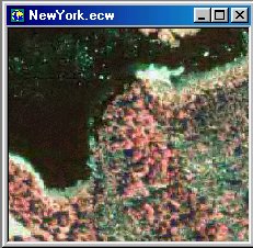
THE FUTURE OF GIS: IS IT SERVICES? One, I'd argue, is data access-especially access to large imagery datasets. If your company is big enough, and has the bandwidth or money, you might buy the files you need-DOQs or DRGs here in the U.S. -for the areas of interest. Or, you could download them when needed from several online services. Or, you might have a look at a new service from Davis and Associates. When I received an e-mail outlining the new service, I confess that I didn't quite understand the offering. But I was intrigued-it had to do with online imagery streamed using Earth Resource Mapping's (ERM) Image Web Server (IWS). Further, the imagery was accessible from any product which supported ERM's ECW format. Robert Nicholson, vice president at Davis Associates explained the whole story. The company resells several vendors' software, including ERM's. After attempting to sell ERM's compression and server technology for imagery, the company learned that most users don't want the "behind the scenes" technology. Instead, they want the data! So, Davis Associates changed its tune a bit and built a demonstration site. After collecting DOQs and orthophotos for New York State, compressing them into large continuous mosaics, a team installed them on a server at the company's ISP equipped with IWS. That means that anyone with the ability to access ECW data-either in ERM's free ERViewer, via a plug in to their chosen GIS system (many, many are available) or using a Java download in a browser-can use the images. Let's be careful about "use"-the images are not downloaded, but streamed. They will, however, act just like they are local in most cases. They can be used to rectify vector data, for example, or used in creating screen captures. And, Davis Associates has taken this use even further for users of ArcGIS. That product can reproject local images on-the-fly already. Davis Associates has added that same functionality to images served from Image Web Server. Below is a bit of the New York data streamed into ER Viewer.
But there are few other, more subtle aspects to this solution. First off, it's available to a wide variety of GIS software from Autodesk, ESRI, MapInfo and others. Second, the streamed images can be part of a Web solution, like MapGuide, or a desktop solution, like Manifold. And, since it's hosted on a server, differential security can be used to serve imagery only to those approved to use it. Now the burning questions: What's the catch if you are a user? How do you make money, if you are the host of such a service? If you are user you pay for the service-and get a discount if you purchase software or upgrades from the company or use ERM software already. As for Davis Associates, the possibilities are broad. Nicholson reports that several state agencies are exploring having the company host their imagery while other clients want to purchase the mosaics and host them locally. For now Davis Associates hosts data from New York, New Jersey, Massachusetts and Long Island, as well as the New York State 2001 Annual Lot mosaics.
ON GIS DAY AND GEOGRAPHY AWARENESS WEEK Harvard celebrated GIS Day. The school is infamous for dropping its geography department years ago. MapInfo celebrated GIS Day in New York. My sense is that in the early days of GIS Day, the leadership in the event by a vendor made other vendors wary about participating. I'm pleased that MapInfo has stepped forward as has Intergraph, in recognizing the event. Large and small GIS-savvy organizations small are using the day to highlight and celebrate what they do. On GIS Day alone a search on Google pulled up news articles about events in Charlotte, Detroit, San Bernardino, Chicago, Topeka, Richmond, Tallahassee, Duluth, and Myrtle Beach among others. The GIS Day site highlights programs hosted worldwide. That's the good news. But I think there is some not so good news, too. What happened to Geography Awareness Week, the event that begat GIS Day? In my completely unscientific wanderings on the Web this week, I found many mentions of it in relation to GIS Day, but found very few discussions of the weeklong event itself. One of the rare examples: The Chicago Tribune highlighted that this is the 13th year its travel section is running a Geography Challenge during GAW. I'll ask the question: Is GIS Day overshadowing Geography Awareness Week?
REFER A FRIEND, WIN A PRIZE! As we head toward the holiday season, give a friend the gift of information: share the insights you receive each week in GIS Monitor. This is the last week of our promotion - the last chance to grab some gifts for yourself. For every person's e-mail address you suggest as a new subscriber, you'll get a chance to win a series of GIS books for your library, provided by ESRI. If for some reason your friend does not find GIS Monitor valuable, unsubscribe information is in every issue. To add your friend(s) to the subscriber list, visit our referral page. If for some reason your friend does not find GIS Monitor valuable, unsubscribe information is in every issue. Good luck and thank you for your continued support!
LETTERS "My explanation would be that all your life you have learned to interpret your surroundings from a side view (or oblique view) not a top view (or orthographic view). Trained photo interpreters can learn to do a very good job from the top view, but persons with no experience with that view will have problems." The editor replies: That's quite correct - ask my grad school remote sensing professor!
POINTS OF INTEREST � Wireless portal AnyWhereYouGo.com, which shut down recently, has resurfaced under new management this week. The site offers a twice-weekly newsletter on the latest in wireless. � As expected, Stephen Whitaker, the consultant from Greenwich, CT, who wanted access to the town's GIS data has received the support of the state Freedom of Information Commission. The Commission ordered the data's unconditional release by unanimously rejecting the town's claims that unfettered public access to the state-of-the-art database would compromise residents' security and privacy. Greenwich Time reports that the town will likely appeal before turning over the data, including imagery and maps. � London-based Birdlip Maps Company has put together a map of more than 500 "historical, hysterical, genuine, current and downright funny" place names around Britain in its "Latitude with Attitude Map." An article in the Shropshire paper points out names such as Mount Flirt, Hell Hole, and Castle Toot, in addition to eight Californias, six Egypts, three Moscows and even a Purgatory and an Arcadia. And, after a year working on the Atlas of Pennsylvania, I thought that area had the oddest names! � An article in the New York Times (free registration required) explores the apparently sudden rise of unpiloted aerial vehicles, or UAVs. I confess I've heard the term recently more from the folks at the Open GIS Consortium than due to the recent use of a UAV in Afghanistan. The piece points out the many civilian uses for such a craft. Uses to date include: filming air stunts in films, finding coffee groves in Hawaii, tracking weather where pilots fear to tread, and dropping rice seeds in Japan. Though the expense and FAA requirements are quite strict, these may become useful information gathering tools for those in the geospatial arena. � Horry County, North Carolina is dealing with a challenge many counties face: to charge or not to charge for GIS and related data. According to the local paper, a proposal before the county council suggests a $300 annual fee for individuals or businesses to access as much data as needed, or use a "pay as you go" option. Part of the issue, it seems, is that Freedom of Information Act data must be delivered in raw form, while most requestors really want a pretty map. � NASCAR fans can take advantage of GPS, among other things, and see the dashboard of their favorite racers as well as their locations on NASCAR.com. The article is at CNN.com, which along with NASCAR, is owned by AOL Time Warner. � Remote sensing is getting yet another new meaning as car companies put tiny cameras in cars to watch for other vehicles, bicycles, and to track motion in blind spots. Oh, and of course, there is one to monitor the kids. One offering shows images for 10 seconds in the center of the dash. Another keeps an eye on tired drivers. A prototype Nissan navigation system provides a "bird's eye view" as though from above and behind the vehicle. Landmarks are called out. From the article at SiliconValley.com it sounds like it's not an oblique view, alas. � The Software and Information Industry Association is an industry group that has successfully argued to shutdown a U.S. government sponsored website, PubScience, that provides scientific articles for free. The group, which includes publishers who offer a similar service for a fee, argued in an article in Federal Computer Week that "it is fairer to charge researchers for the articles they use than to charge taxpayers for the cost of running a Web site that makes them available for free." SIIA is targeting other free sites that compete with for-profit services, including one focusing on law, and other on agriculture. � Public Safety Associates Inc. has filed a lawsuit against General Motors accusing the company of using its map data without paying, according to RCR News. The suit alleges that GM began shopping its OnStar system and maps to other manufactures without permission. � S1 put out a press release on the appointment of Larry Diamond, currently VP of GIS at Autodesk. According to the release, Diamond will be senior vice president, product development and will oversee S1's five centers of excellence that are responsible for research and development, product development, quality assurance, documentation and testing. � At his keynote at Comdex, Microsoft's CEO Bill Gates highlighted the company's move to "every day" appliances. One caught my eye: "Gates unveiled an 'intelligent alarm clock that automatically adjusts to time zones and grabs map, weather, and scheduling information." Hmm. Is the new slogan, "When do you want to get up today?" � In-Stat/MDR issued a report suggesting that revenues from LBS are still quite far away. Carriers are unlikely, the report argues, to break even from the mandated location technology by selling LBS until the end of the decade. � In the U.S. we track our children; in Norway, they track sheep. According to the EETimes UK, Norwegian contract manufacturer Kitron Development AS has developed a GPS satellite navigation and VHF radio device for free-range domestic animals. A battery powers the device for about a year and locates the animals to within a few meters. Future developments will track pulse, temperature, and other vitals to keep the animals healthy. The article notes that the device can report on attacks by predators, though it does not say how. � Government e-Business reports that innovative use of technology in revitalizing neighborhoods often depends on relationships with universities. Discussing a report by the non-profit Structured Employment Economic Development Corp. (Seedco) the article notes that a survey found that few community development groups use information technology innovatively, but when they did, it was through university partnerships. Says William Grinker, Seedco's president, "Most of the standard relationships talk about GIS mapping as a way to provide resources to the community, and that's fairly standard at this point�What I found interesting about these case studies was the institutions moved beyond that and doing more innovative kinds of technology programs." � Cuts at Central Oregon Community College may mean the end of its GIS program, and, important to me as a fellow community band member, the community band!
� Announcements A vast cache of satellite imagery along the Lewis and Clark trail will become available to the public for the first time through a new partnership between NASA and GCS Research, a geospatial information technology company in Missoula, MT, the Montana State University TechLink center announced. ESRI announced the second and final distribution of its homeland security grants. This list of winners is available here. Resource GIS and Imaging Ltd. (RGI) announced a promotion on all Landsat 7 scenes produced from raw Landsat 7 data archived by Natural Resources Canada, the Canada Centre for Remote Sensing (CCRS). The CCRS archive of raw Landsat 7 data for over 91,000 Landsat 7 scenes, covers all of Canada, eastern Alaska, most of the Continental USA and Northwest Cuba, and is updated daily. The promotional price of $US 390 per Level-1G Landsat 7 scene, reduced from $US 600, will be available until December 31st, 2002. GeoSpatial Solutions reports that Eastman Kodak Company announced that it will close its Citipix business, which had provided aerial imagery to the GIS community since March 2001. Intergraph Mapping and Geospatial Solutions announced that 23 companies from markets such as local and regional government, transportation, utilities, and land information management have been added as Intergraph Team GeoMedia Registered Solutions Provider (RSP) and Registered Solutions Center (RSC) in North Asia. Officials of the U.S. Environmental Protection Agency awarded Massachusetts one of the agency's first annual National Awards for Smart Growth Achievement. Part of the reason: a statewide Community Preservation Initiative (CPI) that includes buildout maps for each municipality online. Hyundai Motor Co. and IBM Corp. are partnering to provide wireless services to vehicles made by the South Korean automaker. Vehicle tracking, stolen car retrieval, news service, and other goodies are planned. ESRI, Sun Microsystems, and PanaStream combined their efforts to produce a new release of GISQuest for educators and professionals to use on GIS Day, November 20, 2002. Blue Marble Geographics now has a development division (Blue Marble GIS Development) that will create custom GIS applications in the areas of image georeferencing, image reprojections, coordinate conversion, vertical transformations, image and map file display, and GPS data integrations. � Contracts and Sales Telcordia Technologies announced that Hydro One Telecom (HOT), a wholly owned subsidiary of Hydro One Inc, has selected TelcordiaT Network Engineer to provide geospatial network management for the company's new and existing fiber optic network. Over the next several months, Leica Geosystems will deliver 32 of its market-leading GPS receivers, 48 high-end TPS1100 total stations, and other products to the Royal Engineers of the British Army. DigitalGlobe announced that its QuickBird satellite imagery is being used by Grafton Technologies Inc. to aid in airport development, management and maintenance. The photos offer the highest resolution in commercially available space imagery. Avineon, Inc. announced that Florida Power and Light (FPL), one of the largest and fastest growing utilities in the United States, has selected the Company to provide Automated Mapping services for their newly migrated GE Smallworld Electrical Distribution Network representing FPL's North, South, East, and West Operational areas. GAF AG has won a contract to set-up a new computerized and countrywide mining cadastre system (SIGTIM) for the Democratic Republic of Congo (DRC). The City of Fenton, MI, approved a $75,710 bid to upgrade the current GIS at city hall to a local firm, North Arrow Technologies of Fenton Township. Even better - the city is purchasing imagery from a neighbor. Good for the local guys! Maporama has been chosen by Accor, a provider of hotels and services, to provide the online hotel locator for the Accor Hotels' reservation website. Quova, Inc. announced that ValueAd.com, a provider of ad server technology services, has licensed Quova's GeoPoint service to provide business-critical geolocation data for geo-targeted online advertising. Grant County, Indiana has recently purchased efiniti mobile, developed by Indianapolis-based Plexis Group, LLC as a way for sheriff deputies to utilize GIS when responding to emergencies within the county. � Products UCLID announced that IcoMap is now available on a "Pay-per-Parcel" basis. Title insurance agencies and other small organizations that are occasional users of parcel mapping software are the target market. Also, the company extended the ArcView Bundle Promotion through the end of the year. The price of the ArcGIS extension will increase January 1, 2003. DMTI Spatial announced the release of its National Parks and Municipal Amalgamation files as part of version 6.3 release of CanMap street map and routing data product line.
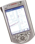
IntelliWhere, a division of Intergraph Mapping and Geospatial Solutions, announced worldwide availability of IntelliWhere OnDemand 5.0, vector-based mobile workforce software for personal digital assistants (PDAs.) New features include support for NMEA 0183 GPS, the National Marine Electronics Associations' industry-standard protocol, and a unicode character set. An evaluation version is available. OpenOSX began shipping its updated Grass GIS 5.0.0 CD and has made a free update available for all OpenOSX Grass 5.0.0 customers. At Comdex, Nokia rolled out its new CDMA handset that offers CDMA operators a new phone as they migrate subscribers to new GPS-enabled CDMA2000 1X networks. The new Nokia 3585i phone (CDMA 800/1900MHz/AMPS) features a wide range of personalization options, an enhanced wireless browsing experience and advanced voice functionality. The Nokia 3585i is expected to ship during the first quarter of 2003. Not to be outdone, QUALCOMM Incorporated announced that more than five million gpsOne-enabled devices are now in commercial use in Japan, South Korea, and the United States. The company claims its gpsOne technology is the world's most widely deployed personal location system for mobile handsets. Navigation Technologies announced digital map coverage in Taiwan. Navigation Technologies' detailed coverage of Taiwan covers more than 4,500 miles of digitally mapped roads, including Taiwan's capital city, Taipei, as well as T'aoyuan and Chungli. SAS, a business intelligence company, and ESRI will release the SAS Bridge for ESRI this month to enable more rapid information flow between ESRI's ArcGIS technology and SAS solutions. � Hires, Appointments and New Offices
ADVERTISE WITH US
CONTACT
SUBSCRIBE/UNSUBSCRIBE |