Letters, Points of Interest, Week in Review (Announcements, Contracts, Products, Events, Hires) Back Issues, Advertise, Contact, Subscribe/Unsubscribe If, for some reason you cannot read this document, visit: http://www.gismonitor.com/news/newsletter/archive/112703.php
EDITOR'S NOTE Next week GIS Monitor returns to Thursday delivery with a report from Autodesk University in Las Vegas. I look forward to meeting readers who will be attending. Adena

The event serves both as a regional GIS meeting and a chance to reach out to the community. I saw many local government users shaking hands with peers they clearly didn't have the opportunity to meet with very often. Students and teachers from a local high school's information technology program joined us for part of the day. I was invited to give the keynote presentation and at the organizers' request tackled the topic "What Will Web Services Mean to GIS?" I got a kick out of the fact that the talk was presented in a chemistry lecture hall and "beamed" to an adjoining one. (I think that was the first time I was "beamed"). I tried to define Web services in the context of what GIS professionals do, examined what "infrastructure" might need to be in place for success, distinguished between the needs of professional and casual users of such services, and tried to predict the future. I think I raised more questions than I answered, and discussions continued informally on the topic throughout the day. The rest of the morning was divided into three parallel tracks. I attended a session by Steve Bein, of RBF Consulting, on the use of Web GIS in Riverside County. He outlined the use of the Web in the Riverside County Integrated Project. The project pulled together some 18 different consultants to think through a plan for the county, which is about the size of the state of New Jersey. I was very pleased when the classic GIS "layer slide" came up in front of a clearly experienced audience and Bein asked, "How many times have you seen this slide? I'm going to skip it." A few comments about the project piqued my interest. The group chose to use eRoom's technology to manage all of its GIS data. ERoom, now part of Documentum, provides an online data management/data storage tool with notification options and version control. The data in the online repository was stored in a single format (shapefiles) and was available in a single place. I'd not heard of GIS projects using this type of "online" document management, though some years ago it was a hot topic in AEC (think Buzzsaw and Viecon). In fact, at one edition of A/E/C SYSTEMS the whole floor was made up of companies offering this type of system. At the time, I don't recall a single vendor ever talking about its use in GIS. I also learned that some of the county's base data, particularly imagery, was proprietary but it was acceptable to share it via a Web GIS. Bein used a term I had not heard, "postgraphic GIS." What he meant was that sometimes the "answer" to a query, while it might use GIS in its creation, is not a map. In the case of Riverside County there were many proposed areas under consideration to be set aside as preserves for plants or animals. Their exact locations were not made available since it might "condemn" that property to be forever undeveloped. To provide data to interested residents about their area, RBF built a tool that would identify which type (or types) of preserve their parcel fell into and provided a PDF of details. This process "cherry picked only relevant information from the more than 5,000 page environmental document based on GIS attributes and produced a document of under 15 pages" for delivery. An online tool to show aspects of the plan was widely used by citizens and the counter staff. The latter group deemed it "more useful than the GIS staff." By that I think they meant that it was more timely for them to use the Internet tool themselves, than to task a busy GIS person. In closing Bein shared an idea that turned out to be "too good." During community meetings those citizens who wanted to speak were given a ticket for their "two minutes" and were asked for their parcel number. When they got up to speak, their parcel was projected up on the big screen for all to see using the same app available on the Web. The reason it was too good: now the politicians want it at every meeting! After a break where I witnessed high school boys consume large numbers of donuts (I guess I've not hung out with high school boys lately), I learned about the use of GIS in the Channel Islands National Marine Sanctuary. The GIS group there tracks habitats, species diversity, and fishing locations for recreational and commercial users. The staff regularly flies over the five islands and does a survey of crafts using a neat little database app. The last session before lunch was a Web Mapping Round Table where local users showed off their Web apps. We saw a tool for learning how to get a permit in Ventura County built on ArcIMS and an app for data access used in Thousand Oaks built with MapGuide. A student and a member of Anapaca GIS, a community service information cooperative, then shared his work with MapServer. He'd installed and set up a MapServer implementation on Windows, that used the OpenGIS Web Map Service Specification to access data the Jet Propulsion Laboratory and the United States Geological Society. After lunch there was dedicated time to look at posters. The attendees moved, as a group, from poster to poster to hear the presenter explain them. This format was particularly effective since attendees learned about their neighbors' GIS projects. Attendees were asked to vote on the best poster and winners took home prizes. What was the most sought after prize? Vouchers for ESRI Virtual Campus courses. Sponsor presentations rounded out the day. ESRI provided an update on ArcGIS 9 spending some time on the new tools for customization. Mary Cook-Hurley of AirPhotoUSA spoke about the aerial work her company is doing in the area. She noted that the general trend is for counties to work toward 1' data, and she noted some states are looking for that, too. Cities want 6" data, and some, 3" data. I asked what more one got with 3" than 6". She showed one example of the town of Sanger. The town chose to fly at 3" to find the cracked pavement, rather than to send out a crew to do a survey. Cook-Hurley has been very successful in helping counties to partner with local public and private organizations to bring down costs. She noted that should a few counties pull together, the potential was even greater.
Hurley shared her time with a representative from Intermap, who explained the plan for NextMap USA, a one-meter DEM for the country. The IFSAR equipment, he noted, can be used to gather 50-centimeter data as well. He also noted that LiDAR is the best choice for small areas requiring detailed DEMs, while Intermap's IFSAR, which is flown on a LearJet (right), is appropriate for larger areas. I hope others had as rewarding a time at their GIS Day events as I did at Ventura College.

AUTODESK HAS UP QUARTER, BUT CUTS ARE AHEAD Autodesk's revenue in the third quarter was up 24%. That translates to a net income of $22.6 million, or 20 cents a share, compared with a loss of $3.9 million, or 3 cents a share, a year ago. That's a record for Q3, according to the announcement last Thursday. Analysts expected 16 cents profit per share for the quarter. Having beaten the street, Autodesk stock jumped nicely last week, to $22.53, up about 16%. The strength in a typically down part of the season was attributed to sales of new products, all of which are outside of the Infrastructure Solutions Division (ISD). The total AutoCAD-based upgrade revenue increased 50 percent to $44 million, and new seats of AutoCAD-based products were 48,600, a 46 percent increase over last quarter. Subscriptions accounted for 14% of Design Solutions Group Revenue. Headcount is down 27 from last quarter to 3,527. The Conference Call On the conference call executives explained that the company had been working with a big time consulting firm to review products and processes. The upshot of that will be the cutting of some hundreds of positions, closing some facilities and restructuring. The monies associated with these changes were not factored into upcoming predictions. One big new word we need to learn: "crossgrade." That's moving from one Autodesk product, not a new version, but to a new product. The company held a campaign to move AutoCAD LT users to AutoCAD or vertical products. In Europe, the Middle East and Africa (EMEA), of the 6,000 crossgrades, one-half were to vertical products, like Autodesk Map. The discussion of the Infrastructure Solutions Division was quite short. The division had revenue up 13% over last quarter, with record growth in government. Map upgrades were up 50% over last quarter. One major telco, which spent hundreds of thousands of dollars last quarter saw such a return ($8 million I believe Bartz said) that the company made a further purchase of $1.1 million. The win was over Bentley. Bartz went on to note ten other wins over Bentley. The Cuts On Tuesday of this week Autodesk announced the extent of the planned cuts: the company will eliminate 550 to 650 jobs, about 17 percent of its work force, and close small offices. The company expects to pay $37 million in charges over the next four quarters for this reorganization. The staff cuts will be primarily in administrative and marketing areas while office consolidations will include offices of some of the smaller recent acquisitions. Autodesk currently has 88 offices worldwide. Staff in the four Marin offices in San Rafael number 879. The first layoff for the company was in 2000. The last big headcount reduction was in 2002 when 250 people were let go. Interestingly, as layoffs are planned, the company will be hiring at its new facility in Shanghai, China, and in its project management product group. One analyst noted that "marketing, sales, and general and administrative expenses account for as much as 52 percent of revenue" which is quite high. As I noted above, the estimates provided in the earlier release did not include the restructuring charges, so Autodesk updated its expected earnings, adding in the charges. Expected earnings dropped: fourth quarter earnings last week slated to be 27 cents to 32 cents a share dropped to 24 cents to 30 cents a share with the charge. For the next fiscal year the forecast of 90 cents to $1.10 a share dropped to 68 cents to 88 cents. Investors took the news well, keeping stock up around $23.00 where it jumped after the good news last week. I'll be curious to see how Carol Bartz positions these changes in her address to Autodesk University attendees next week.

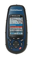
REVIEW: MOBILEMAPPER
MobileMapper is Thales Navigation's new handheld data collection tool. It integrates GPS, mapping, and data capture tools. The company hopes its attractive price will make the product available to those who would have to pass on higher priced offerings. As the company put in its press release, the product is "expected to expand the number of users who will now turn to GPS-based data collection for asset management and field mapping." As I noted when I first saw MobileMapper at the ESRI User Conference, MobileMapper has a medium level of accuracy (1-3 meters), and a $1,500 price point. Recently, I got the chance to work with the unit. The "Quick Start" guide had me installing the batteries, configuring the system, and getting a fix in no time. The print manuals include a "Read Me First" document and a short "Getting Started Guide." The in-depth documentation is a 128-page PDF. Because this is an outdoor device, it might be nice to have a printed manual in a future version. One other point about the documentation: it seems to be translated into English, which makes it awkward to follow at times. The unit is very lightweight. The door for the batteries was easy to open and close, but a glint of daylight visible through the removable panel concerned me. A Thales Navigation representative explained that the seal is actually around the battery compartment, not along the edge of the panel. He noted that MobileMapper is waterproof and actually floats. Preparation The receiver comes with three software packages: a Feature Library Editor, MobileMapper Office, and MobileMapper Transfer. I opened up MobileMapper Office to create a "background map" for a project, basically a raster "picture" on which to lay the data. I'd gathered the data for a mapping project in New Hampshire from the Web. I couldn't use the shapefiles I found as a background map since the data was in New Hampshire State Plane Coordinates. An early version of the software (which I had) required background maps to be in "geographic" WGS 1984. A recent software update solves the problem. Background maps can be created from shapefiles, MIF, or DXF files.
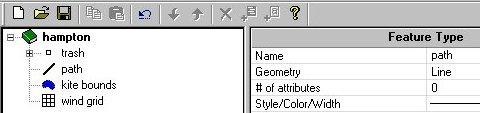
I created a "job" with its own "library," what most of us would call a schema for a database. That process was easy - I could set up choices in pull-down menus, limit input to text or integers, and so on. I set up some point, line, and polygon features to capture some data at Hampton Beach, New Hampshire during a kite fly. It took me a few tries to connect MobileMapper to my computer's serial port, in part because I had left the unit "off." Though I didn't have the hardware to do so, its possible to transfer data directly onto the Secure Digital (SD) card via any SD card reader. The 16MB card that ships with MobileMapper can store more than 100 hours of continuous GPS/GIS data logging. I used the uploading tools to move the files I'd created (the background map and the job) to the SD card. In the Field When I turned on the GPS, it did find satellites that convinced me it knew where I was. Unfortunately, I'd failed to upload the files I thought I had. So, I used the sample job that comes installed on the device to collect some points, lines, and polygons. Choosing items from the menu was easy, but keying in text was a bit tricky. I navigated the alphabetical grid of letters with the joystick-like center button, but slowly. If I managed field data collection people, I'd try to avoid text input to speed up data collection. Numbers were easier to key in, since they could be picked from vertical lists. Back in the Office When I got home to download the data from the GPS, I found the process quite smooth. The MobileMapper Transfer (MMT) program looks like a mini-Windows Explorer program with files from the GPS on one side and files on the computer on the other. You select what to move and "drag them" across. Looking at the program I learned that, in fact, I had not moved over the background map or job I had created.
Once I uploaded the data, I saw that my new data lined up nicely with a TIGER shape file backdrop I'd found. The points, lines, and polygons fell on the correct side of Ocean Blvd. The data (recall I used the default job which had streetlights, roads, and parks in it) was located correctly with the correct attributes. My data was still in the "native" .mmf format and I wanted to work with it in a GIS, so I used the Export command to convert it to shapefiles. MIF/MID and DXF are also supported. All exported files are written to WGS84. Conclusion MobileMapper will be quite a workhorse. At the price point it's easy to arm a fleet of data collection staff with MobileMappers, each loaded with local maps, and custom pull-down menus. With just a short period of training, staff will be bringing accurately located and attributed data into the office. The light rugged unit should hold up well in inclement weather and withstand storage in a pocket or backpack. Thales Navigation offers a wide range of accessories to mount the unit on a bicycle or in a vehicle, allowing data collection however collectors need to travel.

So, last week's question, "What does TerraServer do beyond the use of a basic WMS connection to TerraViewer?" Should read, "What does TerraViewer do beyond the use of a basic WMS connection to TerraServer?" And, last week's statement, "TerraServer is a MapBasic application that provides a pull-down menu to turn on and off the topo maps and digital ortho quad (DOQs) 'layers' that TerraServer provides" should read, "TerraViewer is a MapBasic application that provides a pull-down menu to turn on and off the topo maps and digital ortho quad (DOQs) 'layers' that TerraServer provides." I apologize for any confusion.

POINTS OF INTEREST Tracking London Busses. London busses currently use a mix of onboard technology and beacons on light poles around the city to provide real-time location information. The system, now 15-years-old, costs some L$50 million. This winter trials are set to test GPS for tracking. The bus system is expected to grow to some 10,000 vehicles in the next few years, which makes officials squeamish about the current system. They are also wary of GPS-based systems since one of this magnitude has not yet been implemented. A final decision on a technology solution is expected in 2004. IMSI to Offer Symbols. IMSI, a company mostly known in the CAD world, last week launched a few new websites including CADsymbols.com. The website is subscription-based and in the future will offer GIS symbols. Robot Navigation Takes Award. A navigation system developed by a graduate student from the Royal Institute of Technology in Stockholm, Sweden, recently earned an award for best contribution among 500 competitors at the IROS robotic conference in Las Vegas, Nevada. The system was more efficient than past offerings because it trims down the amount of information the robot has to remember to get around. Robots using the system tap ultrasound or lasers to navigate between known points, so they can "forget" about encountered obstacles between points, saving memory space. Good News for Those Seeking Restrooms. The Australian federal government is looking for someone to update the National Public Toilet Map until August 2006. The database currently holds about 14,000 entries and gets about 400 hits per day. There's a tender out from the Department of Health for hosting and maintenance for a three-year period. The system is built with ESRI software and MapInfo data. Georgia Provides Location-based Services via Plasma TVs. In a first in the nation project, the state of Georgia will sell plasma TVs with real-time traffic information to rest areas. The state will incorporate the technology into all state welcome centers by year-end at a cost of $178,000. Proponents argue the systems are "faster than radio and TV traffic reports" and hope downtown Atlanta office buildings will snap them up. Some of the traffic information is already available on the Web, so I suggest terminals displaying that information might be a cheaper alternative. Daratech is Smaller. Ralph Grabowski reports that Tom Greaves and Bruce Jenkins, both longtime employees at Daratech, left the company last summer, and have started a new venture, Spar Point Research. The company provides business research to aerospace, automotive, civil infrastructure, consumer products, and more. The last I knew Jenkins did the GIS analysis for Daratech.

� Announcements Navigation Technologies announced that it is "the only global digital mapping company to achieve ISO 9001: 2000 certification of all main operating locations." I guess they want to distinguish themselves from GDT, which announced it was certified earlier this week. The Open GIS Consortium, Inc. (OGC) is issuing a Request for Quotations and a Call for Participation in the Emergency Mapping Symbology (EMS) Initiative. The London Central Partnership (LCP), a customer of GeoMicro launched the AccuGlobe newsgroup. AccuGlobe, a freely downloadable desktop GIS product for the casual GIS user, was developed by DDTI and is based on GeoMicro's AltaMap components. You can access the newsgroup here. CityView clients the District of Langford, British Columbia and the New Jersey Meadowlands Commission (NJMC) are winners of the 2003 CityView User Conference Enterprise Awards. TCS was awarded a patent titled "Culled Satellite Ephemeris Information For Quick Assisted GPS Location Determination." The patent reduces the time necessary to determine the physical location of a wireless handset from several minutes down to a few seconds, ideally enhancing emergency efforts and customer satisfaction. By a majority vote of the American Society for Photogrammetry and Remote Sensing (ASPRS) Board of Directors, the Society has issued a resolution calling for immediate support and funding for the continuation of the nation's Landsat Program. In the resolution, ASPRS cautions the U.S. Government to not try to commercialize the Landsat program, since moderate-resolution, multispectral remote sensing satellite systems have not proven to be commercially viable. I'm pleased someone is saying something about this; I felt I was the only one who noticed the state of Landsat. The Open GIS Consortium Inc. (OGC) announced a Request For Quotations (RFQ) from technology developers interested in a major Interoperability Initiative to develop and enhance OGC Web Services standards that enable easy discovery, access, and use of geographic data and geoprocessing services. The OGC Web Services Phase 2 (OWS-2) testbed advances OGC Web Services (OWS), the set of OpenGIS(R) Specifications for interfaces, schemas, and encodings that comprise the interoperability framework for the emerging "Spatial Web." Intel Corp. will argue before a federal appeals court next Monday that a judge in Texas erred in siding with Intergraph Corp. in a patent dispute last year. Intel will be trying to overturn an October 2002 ruling in which a U.S. district judge in Marshall, Texas, found the company's EPIC technology, used in its 64-bit Itanium chips, infringed on patents held by Intergraph. Intel's loss caused a required payment of $150 million. If Intel loses on appeal, it'll have to pay another $100 million to license the technology in question. � Contracts and Sales MapInfo announced that it has supplied Multimap, Europe's leading provider of mapping and location-based services, with its street network routing solution, MapInfo Routing J Server. Marshall has entered into a contract to provide enterprise geodatabase design and implementation services to assist Idaho Power Company. Leica Geosystems GIS & Mapping announced CGR's (Parma, Italy) purchase of the ADS40 digital sensor. PlanGraphics, Inc. was recently selected to receive a $200,000 R&D; Voucher Fund award from The Innovation Group (TIG) of the Kentucky Science and Technology Corporation (KSTC), based in Lexington, Kentucky. The award is seed funding for PlanGraphics to evaluate and develop value-added commercial data products created from high-resolution satellite imagery. The new intellectual property (IP) procedures that PlanGraphics will develop and leverage with the funding will result in the availability of enhanced interpretive products for government and business clients in specific geographic locations around the country. Jupitermedia Corporation announced that MapInfo Corporation licensed its Wi-FiHotSpotList.com database for use in location-based solutions. Wi-FiHotSpotList.com is a leading resource for finding wireless access points around the world. � Products Refractions Research announced the release of PostGIS 0.8.0, the first version of PostGIS to support all the functions in the OpenGIS "Simple Features for SQL" specification. PostGIS adds support for geographic objects to the PostgreSQL object-relational database. In effect, PostGIS "spatially enables" the PostgreSQL server, allowing it to be used as a backend spatial database for GIS. � Events The Ordnance Survey will host a free one-day workshop at the Ordnance Survey's Southampton head office. The event is aimed at businesses and researchers developing applications based on the agency's nationwide geographical information. The event takes place on December 11, 2003. � Hires and Appointments Utility Sciences Corporation (USC) announced it has hired Donna O'Sullivan as Technical Account Manager. Space Imaging announced the appointment of Jim Roper to director of Defense/Intelligence Solutions Sales and John Lee to director of Civilian and Commercial Solutions Sales.
ADVERTISE WITH US
CONTACT
SUBSCRIBE/UNSUBSCRIBE |