Letters, Points of Interest, Week in Review (Announcements, Contracts, Products, Events, Hires) Back Issues, Advertise, Contact, Subscribe/Unsubscribe If, for some reason you cannot read this document, visit: http://www.gismonitor.com/news/newsletter/archive/121103.php
EDITOR'S NOTE Adena

I caught a few more classes after last week's GIS Monitor went to press. Geo Information Interoperability: Key to Protecting Critical Infrastructure This was really a session on the Open GIS Consortium (OGC) and, in part, the role that Autodesk plays in that organization. (I am a consultant to OGC.) We heard about the mission and vision of the organization, how specifications are developed, and a bit about the scenarios of last year's Critical Infrastructure Protection Initiative. While all of this is important, I think there's been enough progress to bring such discussions to the next level: What do OpenGIS specifications mean to me? In this case, "me" is an Autodesk software user. Infrastructure Solutions Division (ISD) Industry Session The very last session before the final party consisted of a series of breakouts organized by industry. This, ideally, was the chance to hear about what's going on in specific corners of Autodesk and ask questions. In the ISD session there was a mix of presentations by users and demos by ISD staff. The two presentations were by users and their respective resellers. The first presentation from Manuel Salas of the Bureau of Reclamation highlighted how that group has made great strides by using Autodesk software. I confess that I'm not sure at all what they did, but apparently it was quite successful. Next up was Frank Sannino from the National Park Service who outlined the challenges he and his group had sharing information with decision makers. The answer was a MapGuide website, which was demonstrated. Next we saw a demo of Civil 3D, which about half the room had already seen and many had also explored. It's clear this is a key part to the future of not just the civil engineering side, but the rest of ISD, too. How do I know? First off, before the demo we were told that Land Development Desktop and CAiCE would stay around as long as users needed them. Second, the data used in the Civil 3D demo was used in the "mapping future technology" demo that followed. I'm not an engineer, so I'm not a great judge of what's cool in civil engineering software. But, what we saw sure excited the two fellows sitting next to me. As I understand it, the big deal here is that the model used is a robust 3D model, and in this product "everything" is connected to everything else-if a line is lengthened the area of the parcel it bounds is also updated. This differs from some existing products where the dimensions of lengthened lines update automatically. There were "ooos" and "aaahhs" for several things that I didn't quite follow, but I'm confident this is very exciting for the engineers. The formal marketing for the product focuses on four aspects: a single model, usability (less clicks), drafting productivity, and design capabilities. That brought us to the new technology presentation. It was made clear that these were not exactly "products" and there was no assurance of when or if these features would come out. First, we saw the Envision user interface on Autodesk Map. I liked that, as I'm a big fan of Envision, in part because of its great interface. The data used was that same Civil 3D model from the previous demo. We also heard about something called FDO, a technology to make read/write access to many different data formats possible. Then we looked at Envision viewing that same Civil 3D model. Map and Envision could both look at the live model. To illustrate the model being live, the presenter made a "live transactional data modification." That is, he made a change in the shape of a parcel in Map. We flipped back to Envision, and with a refresh, saw that change. He explained that changes could be made live, or by using a more traditional "check in/check out" procedure. The final new technology idea had to do with programming. If I understood correctly, a new .NET API, integrated across multiple platforms, makes it "really easy" to build custom tools. One key reason: programmers work against real objects instead of theoretical ones. I'm not sure I totally follow, but it was clear that Autodesk didn't want to give too much away. Locating and Importing Freely Distributed GIS Data I was drawn to this session since I used to present a similar one some years ago, when the Web was young. Back then the big issue was finding the websites that offered free data. This class took a different tactic and presented a single website as a starting point: the now famous website sponsored by the University of Arkansas Library and the Center For Advanced Spatial Technologies (CAST) called "Starting the Hunt." The bulk of the class centered on the trials and tribulations of bring data into Land Desktop/Autodesk Map/Raster Design. Issues included working with different projections and how to bring DLG contour data into a drawing with the contours at the correct elevations. One oddity, when you download a DLG from the state of Texas, it's in an E00 file. The attribute that stores the elevation of contours is called Minor2. This is why the world needs more metadata! It was very nice to see the GIS Monitor URL included in the handouts as a key reference. Handheld App This year Autodesk offered a free download of an application called NearSpace that contained the show info, maps, and other details of the event. I downloaded it to my PDA, and decided it was cool. However, I never used it during the show. Why? The pocket guide in our name badges was quite effective for keeping my schedule. (The PDA app didn't have my schedule, just the overall schedule.) And, perhaps equally importantly, the convention center and show floor weren't so big or complex that one really needed a map.

DISRUPTIVE TECHNOLOGY AND GIS The idea is not exactly new, but it does have a new proponent, a fellow named Clayton Christensen of the Harvard Business School. The clearest description of "disruptive technologies" is from a website of the same name from Analysis Group, a company consulting on the topic. "Forbes magazine refers to them as 'stealth attacks.' But to Clayton Christensen, these 'simple, convenient-to-use innovations that initially are used only by the unsophisticated customers at the low end of markets' are disruptive technologies." There are some very convincing examples of how the "toy PC" took over and killed Digital Equipment Corporation, and how discount chains killed off Woolworths. (There's a CVS where the local Woolworths stood in my hometown.) A brief digression: It turns out Christensen was chairman and president of Ceramics Process Systems Corporation (CPS), a company in Cambridge where I worked during a summer back in the 1980s. My mother ran the Experience Center (what other firms might call the corporate library) and I filed and did database work in a program called CornerStone for her. As I read through the characteristics of disruptive technologies I tried to apply them to industries with which I am familiar. My first thought was that AutoCAD, in its time, was a disruptive technology. In 1982 it offered 80% of the functionality of the high-end CAD offerings for 20% of the cost. Autodesk succeeded, but other companies that tried to do the same thing to Autodesk didn't have that level of success (consider IMSI, for example). As I looked over the questions used to determine if a company is at risk from disruptive technologies, I learned that if you lose low-end customers and "deem them unimportant and not worth protecting" you are prone to disruption. That made me think of "low-end" users who want Web mapping. It made me consider the many, many offerings in that space with low price points hoping to de-seat the traditional players offering "big systems." To date I don't think any single one has jumped out from the pack, but it's a space ready for disruption. Here's one other example from the geospatial marketplace. Remember Wessex? That company, headed by the late Scott Elliot, remapped the data marketplace by offering TIGER data for the entire U.S. for $1000. TIGER data is not known for its accuracy, but packaged up, teh Wessex product was certainly "convenient-to-use innovation" for the "the unsophisticated customers at the low end of markets." There are other technologies in the geospatial marketplace that could be considered disruptive, but I think the value here is in the concept itself. If we as users, and vendors, think about new technologies with this context in mind, it might just help us predict the next "big thing."

PLAYING WITH CANADA'S GEOBASE
Unlike The National Map or GOS, GeoBase is not a tool for examining data or making maps. It's a hardcore data download website. Vector data can be downloaded in GML or shapefiles (core technology here is Safe Software's FME) and images come down in GeoTiff, BSQ (band sequential), GeoTiff per band and PCI Pix (core technology here is from PCI Geomatics). Graphics along the way help users select the area of interest, but there is no previewing. Once the datasets of interest are indicated, a zipped package is created. The user provides an e-mail address, and in a few seconds a message is sent detailing how to download the file from an FTP site. The data is held there for five days. Metadata is accessible on the website, but in my two cases was not delivered with the data. One of my shapefile downloads did come with a rather large XML file. I'm not sure what that was. The site is easy to navigate, and the process straightforward. If I had one request, it would be to report the size of the zipped file in the e-mail. That'd help users plan when to attack large downloads. The FAQ for the website notes that, "Not only is Canada part of a small group of countries in the world to offer access to free and unrestricted use of quality geospatial data to its citizens, but it is the first country in the world to also offer a product that will be sustainable and maintained over time and this in collaboration with closest to the source stakeholders." I applaud this vision, the uncluttered website, and commitment of the many partners. Go Canada!

The two letter writers essentially chastised me for not addressing the topic in GIS Monitor. They felt it was my duty, at some level, to comment on it, despite my relationship with the organization. I disagree. Anything I'd say would be suspect from the start.

POINTS OF INTEREST
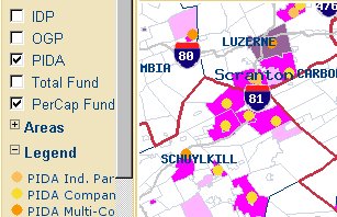
Subsidies Fuel Sprawl. A study published by Keystone Research with maps by ATS suggests that subsidies given out by three Pennsylvania Department of Community and Economic Development (DCED) programs encourage sprawl. ROI in Winnipeg. Peter Bennett, manager of information systems for the City of Winnipeg explains at length, in the local technology publication, of the benefits of the city's CDN $15 million, 1-centimeter GIS. He notes that the City of Winnipeg departments save an estimated CDN$300,000 annually by not having to redraft the base map, and that utility agencies have purchased the base map and pay a fee for update services. The city saved CDN$100,000 annually resulting from a garbage collection routing study that's no longer needed. The city also saved money defending assessment appeals through access to accurate parcel maps linked to assessment data. Heavily Used GIS Website. Arizona's sex offender website, deployed in January 2000, receives 30,000 hits each month. The underlying technology is IBM DB2 database, Netfinity Web server and a Websphere application server. According to a recent study the national average for noncompliance with sex offender registries is 24 percent; in Arizona it's 6 percent. I'm not sure there's a direct connection between the website and the high compliance rate. Tracking Kids Via Games. A writer at GamesIndustry.biz extols the new Gametrac, a gaming handheld with GPS positioning, data communications functionality, and music and movie playback. To be launched in the second quarter of next year in the UK, the device includes Bluetooth support and a digital camera. The GPS part of the equation seems to be aimed more at parents who want to keep track of their kids. Says one partner working on the product, the included GPS "can even provide in-building coverage." The parent company for the product is Tiger Telematics, a company once known as Floor D�cor. Getting Good Service. In an article in CIO Asia, Elana Varon looks at how to get the best service from a vendor. "Lowball tactics eventually boomerang into poor service and support," she notes. One successful example cited is Oakland County, Michigan's dealings with ESRI. "The county got the vendor to agree to a bulk purchasing deal that included 62 of its municipalities. The county and its cities were able to deploy a single system for about one-third of what it would have cost to have each jurisdiction make separate investments." The argument is that smaller villages could not have afforded the software on their own. Phil Bertolini, director of information technology in the county, is credited as noting that, without the deal, municipalities "might not have picked compatible systems. With each community using the same system, county and city officials are able to coordinate their delivery of services in ways they never could before." Mapping Bus Routes for GIS Day. A bus route mapping project by New Waverly Junior High students, "was selected as the best in the annual GIS Day event." The students in Conroe, Texas did the work using ESRI's ArcExplorer among other tools. According to an article, in the local paper, the routes had never been mapped. The school took home "a world atlas with software and a software license for ArcView 8.3, a GIS program worth about $2,500." A Travel Geography Bee. Geographically savvy teens can win an expense-paid trip to Orlando to compete for a $25,000 college scholarship. AAA Travel and the Hogan Family Foundation are offering scholarships totaling $156,000 as part of the second annual AAA Travel High School Challenge. The contest is aimed at heightening travel and geographic literacy and creating awareness of job opportunities in the travel and tourism industries. The national contest is open to all U.S. students in grades nine through twelve. More on Tracking Snow Plows in Massachusetts. Just before the big storm hit the Northeast last week, state plowing contractors agreed to use GPS tracking devices come January. One of the reasons they conceded, according to an article in the Boston Globe: payment calculations were to be handled by an old paper system. I'm not sure how that relates, but I'm glad the roads were plowed. LBS Is Here! Or Not. An article in Newsweek International states, "'Location awareness' has been labeled the next killer app by industry watchers, and it's here now." The rest of the article goes on to basically illustrate how the technology is basically not here yet. One interesting tidbit, the government in Korea is requiring operators to install GPS chips in all new handsets by June 2004. AirIQ Serves the Consumer. The Star (Toronto) has a nice write-up on AirIQ, a location-tracking provider with 40,000 subscribers. The company is based in Canada, but currently makes 90% of its profit in the U.S. Previously focused on the business marketplace, the company will begin offering aftermarket devices to consumers come 2004. The new offering, called MobileIQ, involves a black box installation on the vehicle and tracks its speed, location, does diagnostics, etc. One strength of the company in the marketplace: its profit model is subscription-based, meaning recurring revenue for investors. The Importance of Branding. Three Lafayette Parish, Louisiana students who drew their world won prizes in a NASA/UL Lafayette Regional Application Center contest. It's not exactly clear how the contest was related to GIS Day, but of the winning entries, those from public schools included ESRI's GIS Day logo. The winner, a home schooled student, did not include that logo in his entry. He had a far more interesting circular element in his drawing: a compass rose. GPS Receiver for Urban Areas. Using a GPS in the city can be challenging. Signals are blocked by buildings, while other devices can "jam" what signals do get through. Soanar offers a GPS receiver with enhanced filtering and quick reacquisition and a fancy ceramic antenna just for that environment. Location Aware Holiday Humor. In a rather irreverent article in the Juneau (Alaska) Empire, Jason Ohler suggests why during the holidays "there's no better gadget to give than a location device." Virtual Tags. Want to post virtual yellow stickies in the real world? You can do just that thanks to TagandScan. The system works over existing GPRS networks and users can register for free. Pre-purchased tags are 25p each in �5 bundles or 20p in �20 bundles. Subscribers can scan for and find public tags with their phones. Other tags can be set so only those given permission can view them. Setting or viewing a tag costs a credit. Noise Map. A new European Union program requires noise maps for all its cities with more than 250,000 people, as well as around major roads, rail lines, and airports, by June 30, 2007. After that, plans to "keep it down" will be defined and implemented. In London, the roar of major roads can sometimes be heard a full kilometer away. The maps are not built on sensed data, but modeled based on known amounts of traffic. "Ground truthing" with microphones at 100 locations in Paris confirmed the model's accuracy. The predicted noise was within 1 decibel of that detected by the mikes. The AP story includes links to several cities' maps. Location by Speech. Scientific American reports on a new robot prototype that uses its own speech for navigation purposes. The tall robot uses four speakers to produce automated speech. Microphones placed around its "world" locate it and tell it where to go next. The idea is that it might be a perfect tour guide. Wires on its base help detect objects in its path.
� Announcements ESRI and Trimble announced the winners of the ESRI and Trimble Mobile Government Grant Program. Autodesk announced the winners of this year's Design Awards. In GIS, the awards went to Pima County, Arizona and Seattle Public Utilities. eSpatial, Inc. and the University of Arkansas (UA) Center for Advanced Spatial Technologies (CAST) have entered into a joint venture to establish a Center of Excellence in Enterprise Spatial Solutions on the UA campus. eSpatial will provide software site licenses for its geospatial solution, iSMART. CAST has already been given technology by Intergraph Corporation as a Center For Excellence for the Mapping Sciences, by the Oracle Corporation as its first Center of Excellence in Spatial Data Management, by Sun Microsystems as a Center of Excellence in Distributed Computing for Spatial Data Management, by the Trimble Navigation Ltd. as a Center of Excellence for GPS Mapping Systems: Training and Research, by Skyline Software as a Center of Excellence in Geospatial 3D Visualization and by Definiens Imaging as a Center of Excellence in Object Oriented Image Analysis. Maps a la carte, Inc., (TopoZone) announced it has entered into a Cooperative Research and Development Agreement (CRADA) with the USGS to support the USGS' The National Map project. Under the agreement, Maps a la carte will develop, enhance, and document a suite of Open Source software for serving geospatial data over the Internet. Acxiom Corporation announced that it had reached an agreement to acquire the Claritas Europe group of companies from VNU N.V., a global information and media company based in Haarlem, The Netherlands. 23,732,032 shares of Intergraph common stock were properly tendered at a price of $26.00 per share in the recent Dutch Auction held by the company. Intergraph will purchase 10,000,000, about 46% of those offered. Navigation Technologies is offering sample NAVTECH maps to developers creating applications for QUALCOMM's Binary Runtime Environment for Wireless (BREW) platform that take advantage of Location-Based Services (LBS). MapInfo Corporation announced the recipients of its 2003 Americas Partner Awards. A special nod goes to reader Will Mitchell of Mitchell Geographics of Portland, Maine. His company received a State & Local Government "Above & Beyond" Award. � Contracts and Sales James W. Sewall Company announced that the General Services Administration (GSA) has awarded the company a five-year Federal Supply Schedule contract for environmental and engineering services. GeoDecisions was selected by the Oklahoma Department of Transportation (OKDOT) to provide geographic information systems (GIS) and information technology consulting services to maintain and improve the Geographical Resource Intranet Portal (GRIP) application for the next three years. Starwood hotels selected MapQuest Business Solutions' Enterprise Server v2.0 to provide location information about and directions to its properties. Leica Geosystems announced that it acquired Australia-based Tritronics Pty Ltd, a leading supplier of integrated machine automation and site management solutions for the mining industry. Positive Systems received a Federal research grant valued at approximately $70,000 in conjunction with the NASA Small Business Innovative Research (SBIR) program. The grant funds research to enhance tools to improve alignment and matching of imagery. Positive Systems will be joined by two partners: Dr. Doug Stow from San Diego State University and Dr. Ardeshir Goshtaby from Wright State University. Telecom Fiji Ltd. signed a contract to upgrade its existing Intergraph FRAMME-based AM/FM/GIS application to the company's next-generation G/Comms as the enabling geofacilities management core of its Enterprise Network Resource Management system. Aerials Express LLC, a national aerial photography firm, was awarded a contract to provide the U.S. Geological Survey (USGS) with digital imagery of key metropolitan areas. The company will provide the USGS with 2-foot, true color aerial photography. The imagery will be used and distributed by the USGS to local and federal governmental agencies for use in Homeland Security, first responder and GIS mapping applications. Z/I Imaging Corporation, an Intergraph Company, announced InfoEarth Information Technology Co. Ltd., a subsidiary of Xing Tian Di Group, purchased the Digital Mapping Camera. � Products Mapping Solutions released TerraViewer Plus. With a high speed Internet connection, TerraViewer Plus dynamically brings GlobeXplorer color aerial imagery as a metered pre-paid service into MapInfo Professional. Blue Marble Geographics announced the release of the Geographic Transformer 5.0. Safe Software Inc. announced the availability of FME Suite 2004. New additions to FME 2004 include FME Application Extenders for ESRI ArcGIS 8.3 and Autodesk Envision. FME Application Extenders enable users to directly read FME-supported formats from within their preferred GIS application. MapViewSVG 3.0 is now available for ESRI ArcView 3.x MapViewSVG allows you to convert maps with all layout settings to the SVG format (Scalable Vector Format). Berlin-based company Algo Vision LuraTech GmbH introduced LuraWave.jp2 GEO Edition, a program for the compression of aerial and satellite images in the JPEG2000 format. ESRI announced Business Analyst Online, a Web-based tool that accesses all the power of the desktop product. A free trial is available. Cary and Associates of Longmont, Colo., announced the availability of a market report, "U.S. Federal Procurement of Geotechnology 2000-2002." The report identifies 117 agencies that have purchased a range of geotechnology products and services from 393 companies. Navigation Technologies now offers a map of Canada's entire road network. ESRI Business Information Solutions (ESRI BIS), a division of ESRI, announced that Community Tapestry is now available. Tapestry classifies U.S. neighborhoods into 65 segments based on socioeconomic and demographic composition. SiRF Technology announced that its SiRFstarIIe/LP GPS technology powers the new Earthmate GPS with Bluetooth from DeLorme. ESRI announced the inclusion of GlobeXplorer's United States Geological Survey (USGS) digital orthophoto quarter quadrangle (DOQQ) data with ArcWeb USA. � Events � Hires and New Offices
ADVERTISE WITH US
CONTACT
SUBSCRIBE/UNSUBSCRIBE |