Letters, Points of Interest, Week in Review (Announcements, Contracts, Products, Events, Hires) Back Issues, Advertise, Contact, Subscribe/Unsubscribe If, for some reason you cannot read this document, visit: http://www.gismonitor.com/news/newsletter/archive/121803.php
Editor's Note Here at GITC America, we've also had a busy year. Back in February we acquired Earth Observation Magazine (EOM). Recently, two of the key people behind our print publication, Professional Surveyor, editor Marc Cheves and associate publisher Allen Cheves moved on to new endeavors. Allen served as publisher of GIS Monitor and helped guide it to where it is today. GIS Monitor has been fortunate in recent months to be in the capable hands of editor Patty, graphics/HTML guru, Joel, and the man behind the database, Fred. While our team is small, GIS Monitor readership continues to grow. More of you are writing in with comments, compliments, and contrary opinions. I think its fair to say GIS Monitor receives more Letters to the Editor than any other publication of its kind, which tells me we are covering topics that matter. Thank you for your close reading, your corrections, and your disagreements. The continuing dialog helps our industry move forward. Thanks also to our loyal advertisers. It's most gratifying to hear that they support GIS Monitor not only because it's a method of communicating with geospatial practitioners, but also because they consider it a resource for their own work. The next time you see one of our advertisers at a conference or call for tech support, let them know you appreciate their commitment to this publication. It's ultimately what makes GIS Monitor not just possible, but also available to all who want to read it. Next week, we at GITC America will be on vacation. The next issue will be out on Tuesday, December 30th. Starting January 8, we'll be back to the normal Thursday schedule. Best wishes to our readers, worldwide, during this holiday season. Adena

When GIS Monitor started life at TenLinks, Inc., I began an annual tradition of picking the top ten events, players, technologies, etc. of the past year. If you are feeling nostalgic, you can read up on 2000, 2001 and 2002 in the archives. Now, on to 2003!
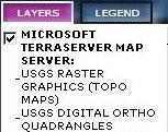
1. New Technology Delivery System of the Year: Web Services - While still in their infancy, geospatial Web Services are available for use. These range from vendor specific ones, such as those offered by ESRI in its ArcWeb Services for ArcGIS, to Microsoft Research's TerraServer USA which supports SOAP and .NET to others, such as those offered by the Commonwealth of Massachusetts, that support OpenGIS specifications. While few of use have used these offerings to date, vendors are offering them, and the brave early adopters are testing them out. I read the first article I've seen in the broader IT media (Computerworld) on the topic just this week. 2. Most Press Coverage: Geospatial One-Stop - If you traveled in geospatial circles this year, you heard about the Geospatial One-Stop Initiative, one of the U.S. government's 24 e-government initiatives and the launch of its portal at geodata.gov. The portal was credited with helping save lives in September when Hurricane Isabel hit the east coast. About a month later, the General Accounting Office criticized the initiative, along with other initiatives:"GAO officials recommended more cross-agency collaboration, improved outreach and better efforts to build relationships in order to make the e-government programs a success." 3. Disruptive Technology of the Year: Open Source - Open source computing follows the strict definition of the concept outlined by Clayton Christensen: it's low priced and doesn't do exactly what users need. But, as Christensen notes, the same was true of PCs and discount stores like Wal-Mart. Look at DEC today, and then, look at Woolworth's.
The other reason open source is disrupting things in the geospatial marketplace: organizations are stepping forward to make sure open source does what they need. Natural Resources Canada, for example, funded the development of standards in the University of Minnesota's open source MapServer offering. Just last week the USGS announced an agreement with Maps a la carte Inc. to develop open source software in support of The National Map. Its also important to note that the first mainstream vendor, to my knowledge, made some of its source code available: Intergraph made the code behind its WMS Viewer website available, though not under an open source license. 4. Most Mature Development Tool: Components - While a few years ago GIS components, OCXs, Java Beans, etc. were the talk of the town, the excitement seems to have died down. MapObjects, MapX, and a slew of others all seem to be a blur. It's not clear whether the technology is mature, has saturated its market, or if something better, services perhaps, has taken its place. 5. Finally in Use: OpenGIS Standards - The Open GIS Consortium's (OGC) OpenGIS Web Map Service specification was approved in 2000, but it's only become a real"player" this year. (I consult to OGC.) Two things lead me to this statement. First, there are lists (though no single definitive one) of URLs that allow users of any client software that supports the specification to tap into servers that do the same. Some of the organizations behind the servers are governments, while others are commercial vendors such as GlobeXplorer and Microsoft.
Second, several desktop GIS products, notably MapInfo's MapInfo Professional 7.5, ESRI's ArcGIS (via an interoperability kit), Autodesk Envision (currently just a prototype), ArcView 3.x (via a no cost extension from a third party) support the specification. These are the products in front of which we GIS users spend most of our time. For the first time this level of interoperability is, literally, in our faces. That means that for the first time, the WMS specification really matters to GIS professionals.
6. Press of the Year: ESRI Press - The ESRI Press now has about 50 titles in its catalog, not counting software documentation products. All of them deal with some aspect of GIS. While other publishers do cover GIS, often from an academic perspective, there's no touching the breadth and quality of ESRI's offerings. There are some misses, but on the whole, ESRI's books are well-written, topical, affordable, and visually stunning. Even though some books are basically marketing offerings, they shed substantial light on GIS use in a variety of disciplines. These tomes, I'd argue, are useful to those who use other products. The books that cover geographic theory and GIS use in education are instant classics. 7. On the Watch List: GISC Certification. GISC's certification is approved, and the paperwork is ready. As of January 1 the proverbial doors are open for anyone who wants to add a few extra letters (Certified GIS Professional, GISP) to their signature and business card. Certification brings tears of joy to some and tears of rage to others. It'll be very interesting to see if the expected swarm of applications come in early in 2004. It'll also be interesting to see if job postings and other requirements documents mention certification any time soon.
8. Where GIS Made a Difference: Columbia Disaster. GIS and mapping people have been called upon to help out in far too many, mostly sad, events this year including the Iraq War, hurricanes, flood, earthquakes, and fires. In following the mapping of the debris from the Space Shuttle Columbia, back in February, I felt the same sense of pride I did in our community during 9/11. Individuals with the appropriate expertise left their jobs and families and headed to Texas to help. Some were relatively local, like David Allen of Euless, Texas, who shared his story with us. Surveyors and mappers came from far off states. In doing so they helped the scientific investigation as well as the mourning process by doing what had to be done. They did geospatial professionals worldwide proud.
9. A Trend that Never Stops: Acquisitions - If you can't think of a big acquisition this year, that's probably because most companies that were acquired were relatively small. Bentley bought Infrasoft. MapInfo bought Thompson and gained sole development and distribution rights to Vertical Mapper. Stewart bought GlobeXplorer. EarthData purchased ISTAR Americas. Intergraph acquired a German company, Terra Map Server GmbH. Japan-based Celartem bought LizardTech. Trimble picked up Applanix and parts of Emerge. And, most recently DigitalGlobe bought eMap International. The biggest acquisition, in dollars, I believe, was Group 1 Software Inc.'s $17 million payment in cash and debt forgiveness to buy technology from Sagent Technology Inc. In publishing, Advanstar picked up Cadence. If there's one trend to tease out of this list, I think it's that some of the hotter technology companies, perhaps including ISTAR, GlobeXplorer, LizardTech, and Applanix need the strong business/marketing acumen of a larger organization. We'll have to keep an eye on these newly acquired players to see how they fare under new ownership. 10. The Best Conferences: I attended many conferences this year: short one-day affairs and week-long vendor focused events. I attended professional organizations' conferences including at least one that was not about GIS. Which ones did I leave with that happy buzz of new information and more questions? Three stand out in my mind. Two were quite small: One was a New England GITA conference, a one-day, inexpensive event, focusing on imagery. I learned about some new technology, got updates on some things I knew, and got a sense of what the experts expect in the future. The other was also one-day: Ventura College's GIS Day event. That conference was about neighbors sharing with neighbors. And, clearly this was important since each session ended with a barrage of questions. The other thing that floored me about this conference was the students' involvement. Because the conference was small, intimate, and informal (the organizer wore a GIS Day T-shirt and I was told not to wear the suit I brought) the college students in the GIS program seemed right at home. The third event, a"big" week-long conference that left my head spinning, was the National States Geographic Information Council (NSGIC) annual meeting. While vendors do attend and sponsor the event, NSGIC meetings always (I've attended two NSGIC annual meetings and one mid-year) feel more like giant problem solving sessions than trade shows or"lovefests."

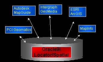
The Platform Even though I was visiting with three spatially savvy people, I found myself walking away with something that should be obvious, but that I think is often lost on GIS people. Oracle is a database company. It doesn't compete directly with ESRI, Autodesk, Intergraph, MapInfo, and other GIS companies. It competes with IBM, Microsoft, and other database companies. Oracle tends to promote things like high performance, high availability, disaster recovery, scalability, partitioning, low-cost LINUX clusters, data warehousing, and most recently GRID computing. If you sit in Larry Ellison's chair (CEO), the prime goal of the company is to distinguish its offerings from other database offerings in order to make money. It's in that context that Oracle entered the spatial arena about ten years ago with Oracle Multi-Dimension, later called the Spatial Data Option. Those offerings have since morphed into Oracle Locator (a set of core spatial tools, packaged with Oracle) and Oracle Spatial (a more advanced set, available at additional cost). How is Oracle doing in differentiating itself from other database offerings with its spatial tools? No other major database vendor, according to Lopez, offers spatial data as a native type, that is, a type that's a full, active citizen in the database's structure. (IBM has licensed ESRI's SDE for use with DB2, which stores spatial data, but the data type is not native. IBM's acquired Informix product does have a native type. Several vendors, Intergraph included, store and retrieve spatial data from Microsoft's SQL Server, but again, it's not native.) A Whole GIS in 10g? When I read the list of new additions to Oracle Spatial at 10g, I thought"They are putting a whole GIS in there!" And, from my perspective as a geospatial industry person, that's just how it looked. But Oracle doesn't serve geospatial users exclusively; it serves a broad base of users in all sorts of public and private organizations. So, one of the points we came back to again and again in our discussions, was that Oracle Spatial serves two kinds of clients: heavy duty geospatial users, and traditional companies. Heavy duty geospatial users have an enterprise-wide GIS problem (think of your favorite national mapping agency, for example, UK's Ordnance Survey) and traditional companies want, as Farley puts it, a bit of spatial analysis"added as a seasoning" to its core information technology inner workings (think of your favorite Fortune 500 company or local retailer, like for example, Blockbuster Video, Pepsi, or General Motors). While the former group's main job in life is to deal with geographic data, the latter uses spatial tools to leverage an existing information technology structure. And, just to be clear, there are many more customers in the second group than the first. What we in the GIS community may also fail to realize is that many of the requirements laid out for Oracle Spatial 10g were not from the heavy duty geospatial user group, but the Fortune 500 group. The two hottest new features, across both groups are geocoding and routing. Lopez also observed that the new Network Data Model is generating more interest outside GIS than within. (The other additions include: topology, raster data support, and spatial analytics.) And, just as there are hundreds of specialized tools in Oracle that only a small percentage of users touch, there are many specialized tools in Oracle spatial that only a small group will use. That, says Lopez, is even true of the GIS vendor community that works with Oracle. An image analysis company, like PCI will be"all over" the new GeoRaster tools, but probably won't touch geocoding. That made me realize that Oracle is really no different from other software vendors. Additional functionality in new releases typically parallels existing offerings from third parties. I was specifically thinking of third party technology from seven or eight years ago for putting raster data into Oracle. Sometimes, for example, in the case of ESRI's ArcGlobe, coming in ArcInfo 9, the technology is licensed from a third party. Other times, the concepts are used, but the technology is built from scratch. I recall making the comment to one of the other journalists at Autodesk University this year that if you want to predict what'll be new in AutoCAD you should look around at what few third party products are still on the market. Using Standards While some companies go out on their own to define new ways of doing things, Oracle is particularly pragmatic. The company has a long history of supporting and following standards that dates back to SQL92, an ISO specification for querying. In the early days of spatial standards, Oracle implemented the OpenGIS Simple Feature Specification. And, more recently, when Oracle determined there was demand for storing topology in the database, it didn't make up its own way to do it, but relied upon the existing ISO standard.
Those choices, along with native support for spatial features, plus the fact that Oracle is the key player in the database marketplace, has made it a virtual requirement for GIS software vendors to support Oracle Spatial. That, in turn, means that the once"pipe dreamy" vision of Oracle Spatial in the middle of the circle as the server and GeoMedia, MapInfo Professional, AutoCAD Map, and other software packages around the outside as clients has become a reality. A recent webcast by Intergraph, MapInfo, Laser-Scan, and Autodesk illustrated just that scenario. Oracle claims that unlike IBM or Microsoft, every major GIS tool vendor (Autodesk, ESRI, Intergraph, MapInfo, etc.) supports Oracle's spatial datatype and that data stored by these GIS products can be easily accessed by other tools and through SQL-based applications. Oracle's DNA As we talked about the new trends in computing, Steiner raised an interesting point about Web Services. While he acknowledged they are great, there's an underlying"gotcha": security."GIS people have some data and want to publish it. They put up a Web mapping server and they are up and running." Later, he notes, the information technology people start asking questions:"How does that work? Where's the security?" Security is one of the things that Oracle provides as part of its platform. Back when the company began its life as Software Development Laboratories, Inc., one of its first contracts was to explore computer security for the Central Intelligence Agency. The code name of the project? Oracle."Security is in our DNA," as Steiner put it, again noting this as a distinguishing feature from other database companies, not from GIS companies. A Quick Look at New Features We took a quick look at the new features. The network data model (which includes routing) is high on the demand list. I asked about loading in data, and like many other spatial features, vendors, or perhaps third parties like Safe Software plan to enhance their current utilities to load data into the Oracle schema that defines the network data model. (NavTech, TeleAtlas, and GDT are planning to support this schema as well.) I noted that this feature would likely be appealing to Departments of Transportation (DOTs). Lopez explained that Oracle already has about 20 U.S. DOTs on its user list - and they've been on board with Oracle Spatial for about three years, since linear referencing (dynamic segmentation) support was added. He also noted that when the notices went out to customers describing upcoming features and looking for beta testers, several big customers in the life sciences stepped up to test out the network data model. Protein interaction and biological pathway applications are now tapping to the same tools that will route repair personnel to downed power lines. Topology support in the database, I was not surprised to learn, was something of interest to the heavy duty GIS user group. Mapping agencies in particular were hot on this feature. Lopez is quick to point out a very small percentage of users will probably tap into it, and, he stated, it's not something"I encourage every user to run out and use." Recall that there's been an ongoing discussion in the GIS community about whether it's better to store topology in the database as ArcInfo coverages do, or derive topology on-the-fly and use it when needed, as shape files do. The fact that both options still exist in the GIS marketplace suggests that we still find places to use both methods. The Oracle platform now offers both a persistent topology model and the ability to generate topology on-the-fly from stored geometries. In Oracle's implementation, users can either use them independently or can use them together in the same database and application. GeoRaster, the group of image support functions, is very exciting to Oracle. Lopez calls it a"big ticket item" since it brings in a whole new set of partners and users, specifically the remote sensing and intelligence communities. Oracle Spatial now has an additional datatype that supports gridded data, DTMs, satellite imagery, orthophoto quads, and other types of raster imagery. All the formats that commonly implement these datatypes can be loaded into the Oracle GeoRaster schema. (Skyline Software and PCI Geomatics will be offering loaders as part of their toolsets.) And, just as Oracle provides only rudimentary tools to look at its networks, there are rudimentary tools to look at raster images. To do any analysis, you'll need a client side package. Oracle is optimistic the major players in this space will support GeoRaster, just as all the major GIS players support vector storage. Geocoding, especially nationwide geocoding, is tricky. Oracle has defined a data format, and so long as data can be put into it, addresses can be turned into latitude/longitude pairs. Oracle has worked with the big data vendors who are committed to supporting the format. There is one nut left to crack: geocoding in Japan. Addresses there are not street-based, but block-based. Lopez is optimistic that support will be coming soon. Spatial analytics is about finding patterns, as yet unseen, typically among data points. This is essentially data mining, but now with a spatial twist. Lopez suggests Oracle Spatial provides the first such system on the market. Application Server
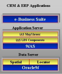
While all of the attention is on the database called Oracle, the company does offer other products, notably an Application Server. It's a Java 2 Platform, Enterprise Edition (J2EE) mid-tier server that includes a series of tools that work against the database. One part of it is called Oracle Application Server 10g MapViewer, and it's just what you might think, a tool to put map data pulled from Oracle on the Web. Here's the interesting part: the release currently under development (the one that will support new Oracle Spatial 10g features) will support raster images from GeoRaster and Flash and Scalable Vector Graphics (SVG). Very few commercial GIS map servers support those two vector formats, so why is Oracle? Flash is a mainstream format, one widely used by the Fortune 500 crowd. SVG, or at least a profile of it, TinySVG, has become the standard for portable devices in Japan. Remember, Oracle has its ear to the mainstream as well as to the GIS community. The Bottom Line The bottom line, for us in the GIS community, is that Oracle's spatial platform is a set of"shoulders" on which to stand. Those shoulders are getting more solid, as well as more broad as the years pass.

MapInfo Introduces Envinsa Mike Hickey, MapInfo's COO, explained what's going on. "The name miAware will no longer be used by MapInfo. As you know, we have been shifting miAware's positioning away from being focused just on the mobile location-based services market. We feel we have a great opportunity to meet the business needs of enterprise customers with Envinsa as our location platform. We also wanted a strong brand to denote both our current capabilities and set the stage for future capabilities. We believed miAware may limit that strategic direction. "Today, Envinsa is synonymous with miAware v3.0. It's a Java-based, Web Services location platform. However, over the coming months, Envinsa will encompass a much broader set of capabilities and will support additional platforms including Microsoft .Net. Beyond that, the key difference between Envinsa and miAware is that the platform fills many more needs than wireless location-based services. For example, more location analysis capabilities were added, and business requirements for industries such as banking, insurance, and transportation were taken into account." I also asked about the meaning of the name. "We developed a new name to reflect the product's central role as a location platform from which many applications can be deployed. The name Envinsa is derived from the following [�] phrases and objectives: "- 'Envision' or visualize solutions I think there are few things going on here. First off, I think MapInfo is trying to"reel in" location-based services a bit and tie it in tighter to its core mission of enhancing businesses with location intelligence. Second, I think MapInfo is moving ahead in its"platform" business. Recall Critical Area Response Manager (CARM), essentially a platform for emergency response, was introduced in March of this year. Finally, I think MapInfo is looking for a new brand, one with a bit of distance from"MapInfo" and"GIS."

"Just wanted to let you know that the AZ Sex Offender website also uses My apologies. The article I read did indeed note that, I just missed it. � Jim Bash noted that one of my links didn't make too much sense to him. "You have a link (http://www.soanar.com.au/) to a firm that is supposed to sell a special GPS for urban areas. Out of curiosity I went to the site to see the specs. It is not at all obvious how one would find the product, the home page basically expects you to login." Mr. Bash is correct. I got the link to Soanar from the website that hosted the article I read. Soanar is a specialist distributor of electronic components that restricts access its website. The good news is that Navman is an OEM (original equipment manufacturer) partner and provides a fact sheet on the technology. The company also appears happy to sell the receiver. � Canadian and fellow ezine editor Ralph Grabowski tested out GeoBase, the new data download portal for Canada. He found an interesting quirk. "I tried accessing a GIS data file but the FTP failed through my Web browser. I then tried an FTP program, and it also didn't work. "Then I noticed the following message displayed by the FTP site: "If your FTP client crashes or hangs shortly after login please try "I placed the dash in front of my 'password' and it worked. I was able to download the .zip file. Good service: average download speed was 109KB/sec."

Points of Interest GIS for the World's Problems. At the European Organization for Nuclear Research's (CERN) most recent meeting in Geneva, scientists explored the challenge posed by United Nations Secretary-General, Kofi Annan, to address the"clear inequalities" between the North and South inherent in scientific activities. Paraphrased in a report from the conference, Santiago Borrero, secretary-general of the Pan American Institute of Geography and History argued that"allowing access to and processing of relevant geographical data through open source geographic information systems (GIS) will enable developing nations to craft policies to maximize their economic, social and environmental benefits." Borrero is quoted as saying,"geographic information is currently not playing a better role in the decision-making process, when it could be used to promote wealth and development according to local needs." Remote Controlled Library Runner. The next time you want to hunt the stacks for a book, the runner may not be a high school or college kid, but a wheeled robot fitted with a digital camera, mechanical hand, and arm. Currently under development, the idea is that one could control the device via the Internet. The robot can select a book, open it, and flip through pages with its own hand, while taking and sending pictures of contents via the Internet. NOAA's Airport GIS. The National Oceanographic and Atmospheric Administration (NOAA) and the Federal Aviation Administration has new pilot program called Safe Flight 21 which involves the development of GIS data layers for 60 airports in the U.S. The data (airport layout diagrams) will serve pilots, air traffic controllers, apron controllers, surface vehicle operators, construction/maintenance crews, emergency/security personnel, commercial and cargo airline operations personnel, and general and business aviation operations personnel information. It is believed that the location information will help develop standardized airport mapping databases and promote safe, efficient surface movements. Stats on GIS Use. About 97 percent of local governments with populations of at least 100,000 and 88 percent of those between 50,000 and 100,000 people use GIS technology. Those are among the findings of a Public Technology Inc. study sponsored by the Department of Interior as part of Geospatial One-Stop. (N=1156) Other tidbits: county use is slightly higher than city use, 77 of respondents use GIS with aerial imagery, 38 percent use it for permitting services, emergency preparedness and response activities, an"overwhelming majorities of respondents say they would allow the federal government to use their GIS data." The report suggested the federal government should take the lead in encouraging widespread use of GIS. The report is available in PDF, and access to tools to manipulate the raw data are available on the PTI website. GIS for Serbia. Early in December, the Director of the Operational Centre of the Serbian Ministry of Interior and head of the working group for the Geographical Information System (GIS) colonel Dragan Zivaljevic demonstrated the new GIS. The GIS budget for the Republic of Serbia is approximately $200,000 thus far. Local Paper Profiles Dangermond. The odd part of the story in the Press Enterprise (registration required) is that Dangermond"declined to be interviewed in-depth for this story." The story's still worth reading and features insights from his brother, nephew, employees, and others. If you are still trying to figure out what makes ESRI tick, this might help. It all checks out based on my eight years there. Another article makes it clear ESRI is not leaving Redlands, which Dangermond calls his"little town" anytime soon. Contract Time at MapInfo. MapInfo Corp. has re-signed its chairman, John C. Cavalier, its chief executive officer Mark Cattini, and five other top executives for three more years. The others include: Michael Hickey, chief operating officer; Gavin Lennox, group vice president of worldwide sales and marketing; Wayne McDougall, vice president and chief financial officer; George Moon, chief technology officer; and Bert C. Tobin, executive vice president of human resources. What Ever Happened to� John Haller, a co-founder of MapInfo Corp. started a new venture called NearMe Inc. in 1999. A Seattle firm acquired NearMe in 2001. What's Haller up to now? Haller runs League Sports Services, a company that produces software to register kids in local sports teams. Why Is Colorado an Imaging Hotbed? Rocky Mountain News takes a stab at that question highlighting the histories of rivals Space Imaging (SI) and DigitalGlobe (DG). There's also some insight into the changes in the company since the awarding of NextView earlier this year. Bottom line: few have left SI, but lots of resumes made their way to DG. Another article notes that more than 40 jobs are posted including openings in customer service, marketing, and engineering at DG. Remote Sensing to Count Corn Stalks. There are laser range finders used for geolocation, and laser measuring devices used in construction, so why not use lasers to count how many corn stalks there are in a row? The sensor, developed at Agricultural Research Service, part of the Department of Agriculture, relies on photoelectric sensors, an emitter on one side of the row and a receiver on the other side. As a tractor travels along the row it sends out a laser beam which, based on how long it takes to travel the distance, helps determine how many corn stalks interrupted it. Ads Come to You. We all fear walking down the street and our cell phones ringing when we pass a store that wants to make us an offer. Well, that's happening in another way, one that does not require your permission. The good new is that for now it is based on a group's information. Mobiltrak, a Phoenix company, offers a satellite dish that enhances (registration required) billboards. Essentially the"billboard" is able to detect which radio station is popular among drivers passing by, and then alter the messages to match the demographic of that station. Connecting Europe and Africa. Spain and Morocco have agreed to build two 39-kilometer tunnels across the Mediterranean Sea to connect the countries and continents. The route chosen has a special feature: the water is but 300 meters deep. Expected cost of initial studies: $30 million. Quote of the Week."This place drives a lot of the deal-making. The idea is to create (a map) once and sell it on multiple platforms - print, digital, CD-ROM." Fran Marshall, president of National Geographic maps in Evergreen, Oregon part of National Geographic Ventures Group, a for-profit holding company, describes her office. Shortcut Mapping. As part of a Robert Wood Johnson Foundation grant, The Nine Nations of North America Goes Political. Remember the Nine Nations of North America? It was a book by Joel Garreau of the Washington Post from 1981. It provided a"new" look at the continent. Reader Vernon points us to a new breakdown of the 10 Regions of U.S. Politics."Each region represents about one-tenth of the national electorate, casting between 10.4 million and 10.8 million votes in the 2000 presidential election." It's an interesting map, have a look.
� Announcements Trimble and ESRI announced today that Trimble will begin reselling ESRI's ArcPad mobile GIS software. The GIS Certification Institute (GISCI) announced that the GIS Certification Program will"go live" on January 1, 2004. At that time, professionals will be able to download application materials and begin preparations for submitting their qualifications for recognition as Certified GIS Professionals and earn the designation,"GISP." Cadalyst magazine has honored GISConnect from Haestad Methods as one of the most innovative technologies on the market. The product received a"Wow! Award" from the publication and is discussed in the December issue of the magazine. The National Science Foundation has selected UB's National Center for Geographic Information and Analysis (NCGIA) to receive a highly competitive, five-year, $3.8 million grant to fund a multidisciplinary, graduate-level training program in geographic information science. The NASDAQ Stock Market Inc. will add Olathe-based Garmin Ltd. to its NASDAQ-100 index starting December 22. The company joins Microsoft and Oracle in the index, which includes non-financial companies. MapInfo Corporation announced that KOREM Inc. will become its master distributor for Quebec to offer customers increased local support. Red Hen Systems, Inc. announced a prototype that will give cellular camera phone users the ability to map their pictures in real-time. The prototype works with Red Hen's multimedia mapping software, MediaMapper, and PixPoint, a software extension to ESRI's ArcGIS that enables the collection and management of spatially referenced digital photographs. The company sees application of the concept to first responders, municipalities, and law enforcement.
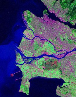
Hundreds and hundreds of satellite"scenes" grouped into"tiles" have been painstakingly pieced together by Natural Resources Canada to create one huge"photograph" of the country as seen from space. The result is a massive mosaic of digital images 85 gigabytes big -- that's more than 100 CDs of data. (The image at left includes Vancouver, BC.) Contact information to get your very own copy is available. A three-year, $736,000 grant from the Association of American Medical Colleges and Centers for Disease Control and Prevention (CDC) will allow Penn State Cancer Institute to develop cancer maps to identify Pennsylvania communities with particularly high rates of colorectal and prostate cancer. Eugene Lengerich, principal investigator for the grant and associate professor of health evaluation sciences, Penn State College of Medicine. Co-investigators are Gary Chase, Department of Health Evaluation Sciences and Penn State Cancer Institute at Penn State Milton S. Hershey Medical Center; Alan MacEachren and David O'Sullivan, Department of Geography and GeoVISTA Center; and Roxanne Parrott, Department of Communications Arts and Sciences, Penn State. Novo is selling its ESRI and ERDAS software distribution businesses in Finland and Estonia to the soon established ESRI Finland Oy, owned by the Swedish company GISFocus Holding AB, which also owns Sweden's ESRI and ERDAS distributorship, ESRI Sweden AB. The change takes place January 1, 2004. Novo is withdrawing from the distribution of these software products, since it does not consider it a core business. � Contracts and Sales Laser-Scan has renewed its agreement to support the map property search service delivered by TransAction Online as part of the National Land Information Service (NLIS). Emerge has been awarded 5,000 linear miles of pipeline work for Marathon Ashland Petroleum and 5,500 linear miles of pipeline work for Gulf South Pipeline Company. The State of New Jersey has awarded a new GIS services term contract to PlanGraphics, Inc. The contract allows PlanGraphics to perform specific GIS services for any State agency, county, or municipality in New Jersey. � Products LEAD Technologies' new LEADTOOLS Version 14 for software developers now supports LizardTech's DjVu and MrSID file formats. ERM released ER Mapper 6.4 is to be released this month. Highlights of the ER Mapper 6.4 release include map reprojection on-the-fly, floating network licenses, and multi-terabyte compression and image management. In other news, the company claims to have hosted the largest image ever on the Internet. The 2 Terabytes of raw data was compressed to an ECW (Enhanced Compression Wavelet) file that is 26 Gigabytes in size - a compression ratio of 80:1. Geographic Data Technology Canada, a developer of premier map databases, today announced the update of Dynamap Canada street and address databases featuring improved geocoding, enhanced positional accuracy and additional routing attribution throughout the nation.
GlobeXplorer released ImageAtlas 2.0, its new aerial imagery viewer. ImageAtlas 2.0 provides instant online access to nationwide aerial imagery and street maps for anyone with a Web browser, with no software downloads needed. Users can order high quality photo prints or download digital files of any selected image online to be delivered to their desktop, home, or business. One new addition: For a small monthly fee, registered members receive a 20 to 25 percent discount on all prints and downloads as well as watermark-less imagery browsing. A more exciting feature: a toggle allows the area under the mouse to display a transparent MapQuest street map over just that area of the image. And, that small area moves as the mouse moves. Leica Geosystems GIS & Mapping released the Leica Photogrammetry Suite (LPS). The Leica Photogrammetry Suite (LPS) is a seamlessly integrated suite of digital photogrammetry products that empowers users to transform raw imagery into reliable data layers required for all digital mapping, GIS analysis and 3D visualization. ESRI has enhanced the data sources available in ArcWeb for Developers. Subscribers to ArcWeb for Developers can now obtain instant access via the Web to real-time traffic information from TrafficCast, current weather from Meteorlogix, recent earthquakes from the U.S. Geological Survey, and much more. ArcWeb for Developers also offers the ability to perform routing and geocoding on Tele Atlas MultiNet street data for the U.S. in addition to existing routing capabilities on GDT Dynamap/2000 and Tele Atlas MultiNet street data for Europe. � Events The International Symposium on Spatial Data Handling will be held August 23rd to 25th 2004 at the University of Leicester, United Kingdom. The Call for Papers is online. GIS-T 2004 with the theme"GIS-T: The Many Faces of GIS" will be held in Rapid City, South Dakota from March 28-31, 2004. � Hires and New Offices Sanborn announced the promotion of Anthony Thorpe to chief technical officer.
Advertise With Us
Contact
Subscribe/Unsubscribe |