| ||
|
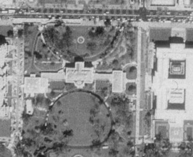
Adena Schutzberg Blurred Images SecurityFocus reported on December 18 that certain aerial images available via MapQuest showed blurred, distorted images of areas including the White House and neighboring Old Executive Office Building and Treasury Department. "The Capitol building and the grounds of the Naval Observatory, where the Vice President's residence is located, have been distorted -- pixilated into an digital blur," according to the article which cites the government secrecy watchdog site Cryptome as its source.
The article goes on to note that the distortion was done by EarthData, which took the images under contract to the U.S. Geological Survey, as part of the National Aerial Photography Program. The distortions were added at the request of the Secret Service, according to a USGS spokesperson. Older images, writer Kevin Poulsen notes, showing the same areas without distortion, are available on the Web and in print. That led Stephen Aftergood, director of the Project on Government Secrecy at the Federation of American Scientists, to note that "except in the case of unacknowledged government facilities, it is hard to see what is gained by this policy, and the downside, I think, is that it encourages public paranoia."
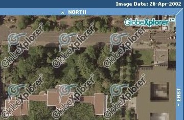
I did my own searching and found that MapQuest no longer hosts aerial imagery on its website. Apparently, its agreement with GlobeXplorer to have an "Aerial Photo" tab on MapQuest-hosted maps has ended. Over at the GlobeXplorer website, I found obscured images. But at TerraServer USA (Microsoft Research's website) I found some nice old (April 5, 1998) USGS images. First We've Heard of It According to an Associated Press (AP) article on December 24, 2003, GlobeXplorer, which buys the imagery from the United States Geological Survey (USGS), was not aware of the changes until it was contacted by the news service. A representative from that company was quoted as saying, "This is the first time we've seen anything like this. We'd prefer that it not be there." The company is considering replacing the altered imagery with commercial replacements that have not been altered. Interestingly, the image associated with the CBS News version of the AP story is a fuzzy profile view of the White House. The story is titled, "The Feds Want Fuzz." A version at USA Today includes an aerial image from USGS, as does one from CNN. How Did This Happen? EarthData agreed to degrade the images in exchange for permission to capture data over Washington, D.C. in April 2002. Flights over Washington have been restricted since 9/11. With guidance from the Secret Service the company blocked out some parts of images and blurred others. Responses Discussions at SecurityFocus generally agreed that manipulating current imagery, despite older data that is widely available, is akin to trying to "stuff the genie back into the bottle." Several posters to the discussion board noted that anyone walking by the areas obscured in the images can acquire detailed information. One other post sounded like a request for metadata about the changes to the imagery. "Strategic places may of course be protected against any unlikely unforeseen hazard, however, with pictures, this simple fact should be mentioned or given some specific public consideration. Just like with the mentioning of copyright. Very easy. Simply balance both interests against each other, and there is a perfectly acceptable solution." The AP article notes that the USGS has been distributing the distorted imagery since December 2002 without formally acknowledging the alterations. The images, the article notes, were part of a project to gather high resolution images of key U.S. cities. Ironically, an NGA [new name for NIMA] representative once claimed that program, sometimes called the "133 Cities Program," did not exist. A USGS representative says no other images from that effort, about half of which are completed, have been altered. Special thanks to Gary Napier at Space Imaging for help researching this story. | ||