Warning: main(http://sparc.profsurv.com/gismonitor/GIShead.php) [function.main]: failed to open stream: HTTP request failed! HTTP/1.1 404 Not Found in /home/sites/www.gismonitor.com/web/articles/comment/082103_sca.php on line 19
Warning: main() [function.include]: Failed opening 'http://sparc.profsurv.com/gismonitor/GIShead.php' for inclusion (include_path='.:/opt/lampp/lib/php') in /home/sites/www.gismonitor.com/web/articles/comment/082103_sca.php on line 19
Warning: main(http://sparc.profsurv.com/gismonitor/toc.php) [function.main]: failed to open stream: HTTP request failed! HTTP/1.1 404 Not Found in /home/sites/www.gismonitor.com/web/articles/comment/082103_sca.php on line 19
Warning: main() [function.include]: Failed opening 'http://sparc.profsurv.com/gismonitor/toc.php' for inclusion (include_path='.:/opt/lampp/lib/php') in /home/sites/www.gismonitor.com/web/articles/comment/082103_sca.php on line 19
| |
|
An Interview with Jason Gerard SCA intern, Jason Gerard shared his experience as a SCA Fire Education Corps intern. Do you come from a GIS background or something else? I studied about GIS and GPS when I was finishing my undergraduate degree at Rutgers University. I have worked for about a year and a half on ArcGIS 8 and more recently, with ArcView 3. I've worked on many projects using GIS software along with GPS, mostly on projects in New Jersey. I have also studied remote sensing and used ERDAS Imagine software, so I am familiar with the different methods of deriving information from and analyzing satellite imagery. When I graduated this year with a B.S. in Environmental Policy I also received a certificate in Environmental Geomatics, which includes aspects of GIS, GPS, and remote sensing.
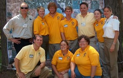
SCA Montana interns and friends joined the Western Governors Association Conference in June. The interns provided hands-on demonstrations of GPS/GIS technologies. All the interns including are wearing yellow SCA shirts, Jason Gerard (profiled here) is the lower left kneeling down and Stephanie Strazisar is the second one standing from the right. How did you find out about the SCA? Why did you chose to apply? I found out about the SCA about two years ago from a friend that had done an internship. My timing for enrolling in a position of interest wasn't right until this year when I was close to graduation and had more time available to commit. I chose my current position with the Fire Education Corps because it was a longer position. I felt would provide me an opportunity to fine-tune my working knowledge of GIS in a real project. What's the goal of your current work? How does GIS fit in? The goal of the project I am working on now is to study and sample plots of land in high priority Wilderness Urban Interface (WUI) areas of Flathead Reservation. I'm collecting information on fuel loads and trees for input into a fire modeling program and update existing GIS layers. I use a Trimble Geo XT GPS unit with ArcPad 6 software installed. I'm keying the information collected directly on Visual Basic scripts so it's easily downloaded onto a desktop PC. I'm using some forestry field collecting protocols. The information collected will make the existing GIS layers even more valuable for temporal analysis and change detection for the after effects of prescribed burning, for example. What's the most difficult part of the position? The most rewarding? The most difficult part of the position for me is keeping track of all the correspondents we have for our project and in what capacities they can help. So, far there is a running list of just over thirty contacts that we have made from all different kinds of fields and companies. The most rewarding aspect, ironically, is meeting these new people that can help us with the project and exploring what they bring to the table. Would you recommend an SCA position for others looking at a career in I would recommend an SCA position to anyone who is looking at careers in GIS, especially those positions that have an emphasis in GIS and GPS technologies. Warning: main(http://sparc.profsurv.com/gismonitor/feedback.php) [function.main]: failed to open stream: HTTP request failed! HTTP/1.1 404 Not Found in /home/sites/www.gismonitor.com/web/articles/comment/082103_sca.php on line 76 Warning: main() [function.include]: Failed opening 'http://sparc.profsurv.com/gismonitor/feedback.php' for inclusion (include_path='.:/opt/lampp/lib/php') in /home/sites/www.gismonitor.com/web/articles/comment/082103_sca.php on line 76 | |
Warning: main(http://sparc.profsurv.com/gismonitor/GISads.php) [function.main]: failed to open stream: HTTP request failed! HTTP/1.1 404 Not Found in /home/sites/www.gismonitor.com/web/articles/comment/082103_sca.php on line 86
Warning: main() [function.include]: Failed opening 'http://sparc.profsurv.com/gismonitor/GISads.php' for inclusion (include_path='.:/opt/lampp/lib/php') in /home/sites/www.gismonitor.com/web/articles/comment/082103_sca.php on line 86