Points of Interest, Week in Review, Back Issues, Advertise, Contact, Subscribe/Unsubscribe
DOES GML ENABLE DATA SHARING? PART II "Our support for OS DNF is basically a generic, non-validating, XML parser with extra smarts. Some of these smarts were forced upon us. For example, OS decided to release 'topological' GML - despite it not being part of the GML 2 standard - so our parser has to 'know' about the topology XML elements. Some of the smarts were our own choice. . . . At Cadcorp we like to read data natively, without translation, and to display it nicely, with automatic styling, scale thresholding, text labeling, etc. We chose to do this for OS DNF because that is what our users have come to expect. So our parser 'knows' about the XML elements that are related to cartographic text. "In addition to our specific OS DNF parser, we also have a generic GML parser that deciphers the GML application schema on-the-fly. This generic parser can load the original Top10 data used in the GML relay." Daly also explained that Cadcorp was unable to attend the Relay because of a clash with the company's Christmas party. Steven Ramage, Operations Director at Laser-Scan Ltd. wrote to share that company's view. Laser-Scan works with Snowflake to provide GML support to its products. Laser-Scan's Dr. Paul Watson is a contributor to the OGC's GML 3 specification, currently under vote by OGC. Watson responded to some points raised in the article. "The whole notion of XML in general and GML in particular is that it can be configured to describe any arbitrary, static collection of data from a library catalogue to a parts inventory of a warehouse to a spatial database. This is done through an application schema written in the XML Schema language. GML is not really an entire application schema as such. It provides the basic building blocks for others to write an application schema for spatial data. "Most software that deals with GML is not schema-aware, referred to as 'hard-coded' [in the previous article]. All vendors bar Snowflake wrote their software specifically to read the Top10NL document. If during the relay, a new attribute (say, number of windows) had been attached to every feature in the "dwelling" class and advertised in the application schema, then these vendors would not have been able to read the new attribute. Snowflake can do this and that is one of their key selling points. "It is our view that whether or not profiles of GML3 should or could exclude topology is not the issue. The real issue here is semantics. Any complex semantics associated with the data (like topology) cannot be conveyed using XML Schema alone. And GML3 is littered with examples of the move away from Simple Features to linked objects. Topology is just one example of many. (Topology primitives cannot ever be treated as features and you get in trouble if you try.)" Laser-Scan has developed an online demonstration which it suggests shows exactly how the GML Relay works. I've not had a chance to look at the demo. I intend to wrap up this discussion of the GML Relay and current implementations of GML next week in the final installment of this series. If you'd like to contribute thoughts, please provide them by next Tuesday, Jan 28.
A WEEK WITH NEVERLOST The plane arrived late into Orlando and we were tired, but we easily found our hotel in the "Yellow Pages" listing and asked for NeverLost to lead us there. We were reminded each time we turned on the system that the driver was not to program the system when the car was moving. We had to click "ok" to acknowledge the warning and continue programming. I'm sure that there for liability issues, since the system couldn't tell if, in fact, the passenger or the driver was fiddling with the system.
We quickly got used to a "two mile" audio warning of the next turn and a pleasant "doorbell" sound when the turn should be happening. For those with an ear for tones, if the route changes roads, the two tones are different. If the directions call for staying on the same road, the two tones are the same. Accuracy was terrific; the doorbell regularly sounded as we began to exit the highway or while we were in the turn lane in city traffic. The woman's voice speaking the prompts seems very friendly. We named her Sidney. There were some oddities. The maps, in vivid colors on a black background, sometimes sported very rectangular water bodies. Of course, many were small retention ponds that are, in fact, rectangular, but even some of the natural water bodies had simplified shapes. Of particular interest to us were several breaks in Route 4, the highway that runs east/west across the state. Even though we were staying on the highway, the directions warned us of a "stay on this road" every fifty or so miles. We decided it must reflect how that segment of road is stored in the spatial database. Sidney thankfully only interrupted when she needed to prompt about an upcoming maneuver - sometimes one as simple as "bear right at the split." Some of these seemed obvious, but it was comforting to know we were going the right way. We also believe the system has an internal compass, since Sidney always knew which way our car was facing. And, of course, our little triangle-shaped car moved along the display to show our current location. The screen, though small, is bright and clear. When you approach a turn the area is magnified. And, while following the route you see the miles to the next maneuver, the estimated time of arrival, and the miles to destination. A click of the View button detailed upcoming exists, included services at each one. When, during one trip west we made a pit stop, we were concerned Sidney would forget where we were going. But once she rebooted, she asked if we'd like to continue and quickly picked up from where we left off. She was also good at recalculating our route if we veered from her directions. Sometimes we did that on purpose, other times by accident. The recalculation process was shown with a progress bar so we knew she was "thinking."
Destinations including addresses can be keyed-in using a joystick of sorts. As you key-in the address, the number of letters to pick from decreases as the system matches your destination with those in its database. I only had to key as far as "New Smy" to have Sidney know I wanted to go to New Smyrna Beach. Hotels and restaurants are available in the Yellow Pages, and you can also select intersections or highway exists as destinations. That said, we were disappointed to select a restaurant in Orlando, find it just fine, then learn that it had moved last May. Luckily, the new address was still on the door and we could reprogram the system. Still, it does make one wonder how often the restaurant data is updated. Two additions we'd like: support for destinations using latitude and longitude, and more consistent warnings about tolls. We'd like the former to support geocaching and off-road activities. As for tolls, Sidney indicated the toll roads in and around Orlando, but did not indicate a toll bridge to Treasure Island, outside of Tampa.
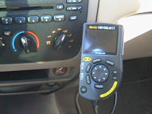
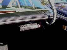
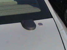
The actual routing selection took some thought. The options are "Shortest Time" "Shortest Distance," "Most Use of Freeways," and "Least Use of Freeways." That gave us pause each time. I suppose I'd have liked one called "simplest." We mostly used Shortest Time and it seemed to work fine, taking us on the major highways. I also appreciated that the database showed multiple names for local roads (SR 599, New York St., 19th St). The system itself is mounted on the dash between the driver and passenger. I did most of the programming from the passenger side with no trouble. And, though I had a bit of glare, the driver said he did not. The computer hardware and software is mounted in the trunk and the GPS receiver antenna is on the trunk lid. NeverLost performed far better than AAA Map'n'Go, a low-cost package that runs on a laptop and accesses an external GPS typically placed on the dashboard. We felt the GPS was far more accurate and the data and delivery far more detailed and clear with NeverLost.
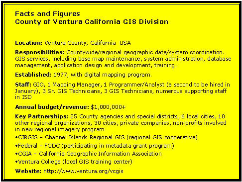
INNOVATIVE ORGANIZATIONS The first organization I want to introduce is the County of Ventura (California) GIS Division. Dawn Robbins, the Geographic Information Officer (GIO) for the County, has a long history in GIS that includes experience at ESRI and Fugro West (on the West coast), and Fugro East (on the East coast). Ms. Robbins holds geography degrees from Dartmouth College (B.A.) and Penn State (M.S.). She and I were officemates and housemates during our graduate studies at Penn State. What is a GIO, exactly? How is it different from a traditional GIS manager? As a GIS Manager, my job was to focus on the business viability and day-to-day operations of a GIS Division. My daily duties included project management, review of technical issues, marketing and sales and staff supervision. As a GIO for Ventura County, my focus is on the best use of geographic data throughout the organization (that is, throughout the entire County). Sometimes the solution to a problem does not involve GIS (at least in the traditional sense), but involves a new application that happens to include maps. For example, two of the questions I am now facing as the GIO are: 1) Why are the Assessor and the Public Works departments performing seemingly redundant map creation and update procedures - one in GIS and one in CAD?; and, 2) How can the County provide access to all land related information (GIS, CAD, graphics systems, legacy databases, etc.) in a consistent, easy to access manner? These questions require a big-picture approach and a certain amount of political knowledge and sales ability to find a solution. Since the GIO is, to some extent, a neutral party, it is possible to study these issues and provide recommendations, where a GIS Manager would likely appear (and should be) biased. What was the biggest challenge you faced when taking on the role? How did you solve it? There were several challenges that took a great deal of energy over the first year: 1) Improving relationships with the other organizations in the region; 2) Firming up a budget for the GIS Division; and 3) Staff evolution. I'll tackle the first one below, since it ties into another question. The second challenge involved creating a budget for GIS. The approach we decided on was an Internal Service Fund (ISF). I created an approach to charge each department for GIS services based on their level of use. The method had to be reviewed and approved by the Auditor, then it had to be presented to the CEO and approved, and then it had to be presented to each of 25 departments. I received buy-in from all 25. This was a major effort, but well worth it. The GIS Division received approximately $1,000,000 through this process and I learned of the geographic data needs of 25 departments at the same time. I then had a year to prove my (our Division's) worth to them. "Staff evolution" was perhaps the most difficult challenge of all. I came into the Public Works Agency to find a staff of five, some of whom had been here for more than 30 years. All had been here for at least ten years. They are excellent at technical map production and update. However, my experience has taught me that GIS professionals must be creative, out-of-the-box thinkers, and my staff did not seem to have strong skills in that area. I changed things, including small but important details such as phone usage (many did not have phones when I arrived) to more sweeping cultural ones, such as our monthly "GIS Lunch" where we get together and dream about what could be� I tried to foster an environment where these individuals were encouraged to come up with ideas about how GIS could be used to help other departments. It seems to be working. We now have a staff of eight, plus a regular consultant, plus several ISD (Information Systems Department) staff who work with us and I can see ideas flowing and real enthusiasm about what is happening here. What is the most important skill for a GIO? A GIO must have the basic technical knowledge of GIS, database and IT processes. But, this knowledge must be coupled with vision, political awareness, and a strong sales ability. A GIO mirrors the eclectic nature of GIS itself, as the individual must be able to work in a variety of locations (agencies, cities, etc), and at various administrative levels. This is difficult - I don't believe I'm there yet. How do you encourage your team and keep it excited about its work?
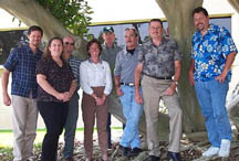
I think about this a lot, as I feel that my staff is the key to success. I have tried many things, but I think these are the best ideas - training classes (they get to choose where, when and what), regular notes and "thank yous" to the group that applaud a new application or map into which somebody obviously put some creative thought, monthly GIS lunches where we get together and brainstorm about what we're going to tackle next or how to get a particular department to buy in, a GIS brochure/website that specifically introduces each individual and describes their skills, GIS Day events (we had two last year, one for the County and one for the Region), where staff get special recognition. [Robbins is in the white shirt.] I have tried to put the emphasis on the importance and value of creative thought, rather than simply showing up each day and doing some sort of map production work. Amazingly, the production work seems to be less of a chore and staff feels rewarded when they get to work on a special department application. I can't overemphasize how great a job they are doing. You've helped re-price GIS data from the country for public, private and non-profit users to a reasonable level. Why do you think this is important? How did you make it happen? Relationships with outside organizations were in a shambles when I started here. I believe that this was due to an expectation of these outside organizations to pay unrealistic amounts of money to access the parcel database. There was no negotiation. It is my opinion that this policy effectively stunted GIS growth in the area for many years. I felt I had to tackle this problem immediately to foster the growth of GIS and, more importantly, the effective and cooperative use of all geographic information throughout the region. I proposed a lower annual fee ($3000) for all users, which was based on my research into successful regional operations, such as SANGIS, and based on my personal audits of our time spent on data updating. I made it happen by getting CEO support early on, and then getting support from influential Department managers until it finally went to the Board of Supervisors and was approved unanimously. It was not easy and some managers still do not support this idea. The upshot - we have 6 of 10 cities participating, plus many other organizations. This has resulted in regular regional meetings and some very positive regional discussion on future directions. Financially, the policy has been a success. The County was able to collect about $15,000 per year with the previous data sales approach. We have collected more than $40,000 in the first six months of the new data maintenance policy. What do you expect to be the biggest change in local government GIS in the next five years? The biggest change I see is the move from a focus on traditional GIS operations to a focus on the use of geographic information within the IT environment. This change implies an emphasis on integration - both technical and organizational. The use of geographic data in Ventura County is expanding dramatically, but outside the realm of traditional GIS. For example, we are considering developing a portal to provide access to all land records, on the Intranet and Internet. The portal itself is not a GIS tool, but it will link to the GIS database and many other GIS-enabled applications. Our GIS data need to integrate seamlessly throughout this land record system. This is a technical challenge and an organizational challenge for our County. The land records portal is only one example. I envision that GIS will need to integrate with all major systems, from our accounting system to our criminal justice records system. The question has changed from "Do you need GIS in your app?" to "How do we get location into your app?" The need is there. The ideas are flowing. Can the technology and the keepers of the technology do it? If you would change one thing relating to GIS technology or policy to help you do your job, what would it be? I would like the emphasis of our industry to change from "doing GIS projects" to "integrating GIS," or even better, "integrating location," into our business processes. Out of the emphasis change would be more information about how to integrate with other IT systems. At Ventura County, we are hungry for this type of information, examples, etc. Secondarily, I would like vendors to know that anything I buy must have a strong business case. Please don't try to sell me anything because it is cool - I can't afford to have our operation be considered "cool" or "high tech." It must be considered simply an integral part of the County workflow. Has your work changed significantly since 9/11? How? The effect of 9/11 for me has been a strong interest in GIS from the Sheriff's Emergency Operations Center. Their realization of the use of GIS in NYC led to a jointly-funded trip to NYC, where I was able to identify and present the practical use of GIS for emergency response to our officials. I'll never forget the representative from the NYC Mayor's office point to me among a large crowd and say "This person, the GIO, is the most important person for you all to know and work with". Our officials got the message, and our working relationship is much tighter.
Do you work for an Innovative Organization that should be profiled here? Drop me an e-mail explaining why.
POINTS OF INTEREST � The following quote from a Washington Times op ed piece by Gary J. Andres makes it clear how the language of geospatial technologies is invading our day-to-day lives: "Navigating between legitimate opposition and petty obstruction, without scraping the tall timber represented by his party's presidential aspirants, will require that Mr. Daschle's political GPS system be fully charged." � A quartet of articles in the New York Times article reviews the latest issues/topics in consumer products for tracking and online mapmaking. The first outlines some of the bigger online mapping sites. The reviewer particular likes the Yahoo site. Another article highlights new tracking devices. A third puts online driving directions through their paces concluding that a good dose of patience and common sense help out quite a bit when using these services. The final article looks at tracking from the societal and personal points of view. � I noted recently interest in RFID tags to track merchandise on store shelves. Michelin has begun fleet testing of an RFID transponder embedded in its tires to enable tracking. What pushed the tire company to do this? A new law passed after the Ford Explorer/Firestone Tire issues of a few years ago.
� Announcements European Union officials suggest that Galileo, the proposed navigation system, could be stalled again by disputes over which country gets what contracts. Later in the week, the European Commission announced its intention to proceed with the Galileo project despite disagreements within the European Space Agency (ESA) over the distribution of financial contributions. While the European Commission has expressed disappointment in the delays within ESA, it hopes that the agency will be able to release their financial contribution of 550 million euro in the coming months. Inforetech Wireless Technology Inc. a supplier of GPS technology for the golf industry, announced that Satellite Golf, Inc., a Nevada corporation, has acquired the distribution rights for Nevada and first rights of refusal for Oregon. ESRI's distributor in Norway, Laser-Scan used Snowflake Software's Go Loader product to quickly read the GML data (provided by TDN) into an Oracle9i database during December's GML Relay. The company representatives then used the Radius Topology Configuration Manager to structure it. The structuring process built and checked the spatial relationships in the data - the shared boundaries between properties, roads meeting at unique junctions, adjacency between buildings and roads. Radius Topology was the only application in the GML Relay to detect a logical inconsistency in the supplied data. Ordnance Survey Great Britain (OSGB) and Kort & Matrikelstyrelsen (KMS, Denmark) are the first members of the Mapping Agencies Generalisation NETwork (MAGNET) project. MAGNET aims to consolidate and extend current generalization capabilities in line with the business requirements of its members. The organizations involved in MAGNET will drive the development of Laser-Scan's newest automatic generalization product: Clarity. Four industry leaders, Autodesk, BAE SYSTEMS, Intergraph Mapping and Geospatial Solutions and Northrop Grumman Information Technology (IT) have committed significant resources to the Open GIS Consortium's (OGC) Critical Infrastructure Protection Initiative (CIPI). CIPI aims to test the application of interoperable technology to meet critical infrastructure protection needs for coordination of geospatial data and services between national, state, provincial and local governments, and commercial and non-government organizations. In other OGC news, sponsors, participants and invited guests gathered at Lockheed Martin recently to view the results of the OGC Web Services 1.2 Testbed initiative. MapInfo announced results for the first fiscal quarter ended December 31, 2002. Revenues for the first fiscal quarter of 2003 were $20.9 million compared to $22.8 million for the same period last year. Net loss for the quarter was $1.9 million, or $0.12 per share, compared to $1.6 million, or $0.11 per share, in the prior year period. � Contracts and Sales Getmapping has won a contract to supply British Waterways with aerial imagery of its complete network of canals and inland waterways. The imagery, supplied digitally for viewing on-screen with electronic maps, will be used to help with the management of this important 200-year old national asset. STAR INFORMATIC announced that Belgium's Airbiquity's aqLink software will be installed beginning this year on vehicles equipped with the OnStar telematics system. The aqLink software will enhance OnStar's ability to transmit data over most wireless air interfaces. Space Imaging announced that it has been awarded a multi-year satellite imagery capacity contract by the National Imagery and Mapping Agency ( Allen County, Indiana, has selected ESRI for its countywide GIS. With a goal to develop an enterprise GIS on one common platform, the county has begun and ArcGIS implementation that will use ArcView, ArcInfo, ArcIMS, and ArcSDE. The Department of Survey and Mapping Malaysia (DSMM), the government agency responsible for all topographic mapping in Malaysia, has chosen Intergraph's GIS, cartographic, and photogrammetric solutions for its new Fast Mapping System. RESOURCE21, LLC announced that the company has selected Pixxures, Inc., a provider of online mapping services, to develop and host the company's AgSense Production System and archive of digital imagery. Using Pixxures' WebPix online delivery platform, RESOURCE21's network of agronomic service dealers will be able to use image-based data to develop value-added services, product application maps, and knowledge to be used in future management plans for their customers - generally growers. Telemorphic, Inc. is subcontracting to Pixxures to provide the map interface for the AgSense application. � Products Mapopolis.Com, Inc., a provider of Navigation solutions for handhelds, announced the immediate availability of Mapopolis Navigator Dell Axim Edition. The new bundle turns a Dell Axim into a navigation system. LeadDog Consulting announced the release of American Territories street-level geocoding maps. It's designed for any industry needing to geocode addresses in the American Territories-Guam, the Virgin Islands, and Puerto Rico. Tetrad Computer Applications Inc. is shipping PCensus with 2001 Canadian Census data covering age, sex, marital status, families, dwellings, households, language, mobility, and migration. 2001 census data purchasers will automatically receive the remaining four releases (ending in June 2003) as soon as it is available from Statistics Canada. MapQuest announced the launch of its next-generation mapping and location-based service for businesses - MapQuest Enterprise v2.0. A powerful, locally-hosted solution, MapQuest Enterprise v2.0 allows businesses to map and route-enable their Web sites, intranets, extranets and wireless applications to better serve their customers and improve the way they do business. The Geodetic Information and Trade Centre (GITC)has published The Electronic Chart; Functions, Potential and Limitations of a New Marine Navigation System. The book is written by experts in the field (Horst Hecht, Bernhard Bernking, Gert B�ttgenbach, Mathias Jonas, and Lee Alexander) and describes the basic components, functionality, and capabilities and limitations of Electronic Charts. Maporama announced the availability of Maporama Search Deluxe, a new product that allows the user to pinpoint a selection of addresses on a single map. Maporama Search Deluxe means Maporama's customers can access a simple and powerful tool to highlight pre-defined addresses from the Maporama Partner Base. MacDonald, Dettwiler and Associates Ltd. announced that the company's U.S. subsidiary, DataQuick, is introducing an analytical tool on the Internet that allows realtors and lenders to monitor property market trends on a monthly basis. TrendFinder provides home sales analysis by county and Zip code. ESRI released ArcPad 6.0.1 and ArcPad Application Builder 6.0.1. The latest release of ESRI's mobile mapping and GIS technology addresses a number of key issues including a new map rotation tool, support for localized languages, improved symbology, and extensive enhancements to the ArcPad object model and the customization environment via ArcPad Application Builder. IMB Enterprises, Inc. of New York, a consultancy, has signed an exclusive agreement with DATECS, Ltd. of Sofia, Bulgaria, to market DATECS' Map Datasets for the most prominent Bulgarian Cities to the Americas and Western Europe markets. The datasets are immediately available in either MapInfo or ESRI Shapefile formats. � Events GIS Cafe announced that its VirtualGISCafe online show would occur after the non-virtual GITA and Geocom (not sure what show this is) events to accommodate potential exhibitors. The event, originally scheduled for February will be held April 15-17, 2003. CARIS 2003, a CARIS user meeting will be held in St. Louis, Missouri November 18-21, 2003. � Education and Training The Geography of Health Care Planning and Marketing is a new ESRI Virtual Campus course that teaches how geographic information system (GIS) software can be used by health care professionals to optimize service delivery and identify new marketing opportunities. Northwest Missouri State University soon might offer the nation's first online master's degree in geographic information systems. The program is awaiting approval from the state's Coordinating Board for Higher Education. � Hires and Appointments Spatial Business Systems Inc. announced that it has expanded operations to a new office location in Lakewood, Colorado, adjacent to the Denver Federal Center. geoVue announced the appointment of Diana M. Bolick as the company's new Vice President of Marketing. The Open GIS Consortium, Inc. (OGC) announced that Ron Fresne has joined OGC's staff as interoperability Initiatives Manager. Working with teams of technologists from agencies, companies, and universities around the world, he will have overall responsibility for ensuring the successful execution of OGC Interoperability Initiatives.
ADVERTISE WITH US
CONTACT
SUBSCRIBE/UNSUBSCRIBE |