Points of Interest, Week in Review, Back Issues, Advertise, Contact, Subscribe/Unsubscribe
EDITOR'S NOTE Also, I'd like to ask a more broad question: What do you consider "location-based services" to mean? What are they? Send along your definition and I'll share the responses. Finally, I've received several requests lately to change subscriber e-mail addresses. I'm happy to do that, but please be aware you can make the changes yourself at our subscription page. Be sure you know the e-mail address under which you currently receive GIS Monitor (you can find it in the "to:" field of this e-mail). You'll need to "unsubscribe" your old address, then add your new one. Thanks readers, for your continued support. And, thanks to our advertisers for making GIS Monitor possible.

The State of Things at Space Imaging
Just last week the National Imagery and Mapping Agency (NIMA) announced that Space Imaging, along with competitor Digital Globe were selected as contractors for the CLEARVIEW project which will pump millions of dollars into each company's coffers. Copple has been working recently to tighten up the company to reflect the reality of the economy for satellite imagery, so this strikes me as an odd time to choose to leave. Space Imaging's Business Case Copple had commented in a release about the CLEARVIEW award that "With this contract, Space Imaging has accomplished another milestone that closes our business case." I asked Gary Napier, Space Imaging's Public Relations Manager, to confirm the nature of the company's business case. He explained "Space Imaging's business model has always been to make high-resolution satellite imagery available for commercial use. As with many emerging technologies, having the federal government on as an anchor helps stabilize the company so that it can develop the commercial industry. Educating and marketing to the many markets that can benefit from commercial satellite imagery is expensive and takes time. Even though the CLEARVIEW contract is with the National Imaging and Mapping Agency, the imagery is still commercial, as opposed to classified imagery from the U.S. Government's own national systems. Imagery taken for NIMA under terms of the CLEARVIEW contract remains in our commercial archive and is available to all of our customers." Even with the new contract he confirms, most of the company revenue will be from "international and commercial markets." Space Imaging Investors, History and Future Plans Space Imaging's main investors are Raytheon and Lockheed Martin, who are joined by smaller investors including Mitsubishi and Hyundai. The relationship played out this way: Lockheed Martin built IKONOS, the company's current eye in the sky, Eastman Kodak provided the sophisticated camera sensor, and Raytheon developed the ground station, communications, image processing, and customer service component. Mitsubishi and Hyundai each own a ground station. For comparison, DigitalGlobe, originally known as EarthWatch, owns the QuickBird satellite designed by Eastman Kodak Co., Ball Aerospace and Technology Corp., and Fokker Space Bv, and is supported by investment from Ball Aerospace, ITT Industries Inc., Hitachi Ltd., and Morgan Stanley, Dean Witter. While both Raytheon and Lockheed have cut losses as defense spending picks up, both took losses on SI in the last quarter of financial 2002. Lockheed Martin, which owns the largest share of SI, took a $106 million charge this quarter related to the "impairment of its investment in the company and its guarantee of its existing credit facility." Raytheon acquired a minority share of Space Imaging with its acquisition of E-Systems Inc. in 1995. According to the Boston Globe, Raytheon took a $175 million pretax charge to write off its investment in SI and to pay down a credit facility there. IKONOS is SI's flagship. Launched in September 1999, it had a designed life span of 5-7 years. Napier says the system is quite healthy and that SI expects it to remain operational beyond its original life expectancy. He also reminds me that Landsat 5 was launched in March 1984 and is still providing data. SI's future satellite plans look bright. In December 2000 the company received a license from the U.S. Government to launch and operate a half-meter commercial imaging system. IKONOS provides 1 meter imagery while DigitalGlobe's QuickBird provides 0.62 meter products. The company will seek financing for this satellite and hopes to have the new system in orbit in 2006. But SI is not only in the satellite imaging business. Along with Pacific Meridian, a GIS services firm purchased in 2000, SI runs an aerial imaging business, the key to which is the company's own sensor-equipped airplane, the Digital Aerial Imaging System (DAIS). Napier explains that SI "understands that 1-meter resolution satellite imagery isn't the solution to all remote sensing needs." To fill those other needs SI provides lower resolution imagery from the Indian Remote Sensing (IRS) series, Landsat and RADARSAT. Early on, the company bought EOSAT Corporation, the first company to commercially operate a remote sensing satellite, Landsat 4 & 5. And the company uses the DAIS or contracts with other aerial imagery firms if it is not available for higher resolution imagery. With all these options the company offers imagery from 180-meter resolution down to six-inch resolution. The Satellite Imaging Marketplace The recent contract with NIMA suggests to me that although there was great hope of civilian commercial use of satellite data, it has not really panned out. An article in Signal Magazine, forwarded to me by Napier, notes that the media was expected to be a big buyer. In point of fact, Tim Brown, senior associate at GlobalSecurity.org reasons that the high cost of the imagery, coupled with its inability to be delivered in time for the news cycle, prevented large uptake in that area. Chuck Herring, director of marketing communications at DigitalGlobe concedes in the same article, that while satellite imaging is fine for mapping, its not "may not be the best choice for supporting the tactical commander." That suggests to me that certain time sensitive commerical users may look to other technologies for quick turn around imagery. Central Intelligence Agency Director George Tenent last June made it clear that the military was to use commercial satellites "almost exclusively" for mapping. Tenent's memo specifically states that the goal is to "stimulate and maintain�a robust U.S. commercial imagery industry." That produced wide smiles at the satellite imaging companies, I'm sure, and bigger grins when the CLEARVIEW contract was signed last week. A press release perhaps related to the signing of the CLEARVIEW contract, reported that ORBIMAGE, which has been involved in a court battle with Orbital Sciences Corporation, announced this week an agreement to settle. Is it possible the company hopes for its own share of the CLEARVIEW monies? Kevin O'Connell, a senior analyst at the Rand Corp. argues in a UPI article, that the CLEARVIEW contract takes a different tactic than NIMA's 2001 exclusive agreement with Space Imaging to "own" all of the companies imagery of Afghanistan. The agreement, he suggests, aims to allow the "Pentagon and intelligence agencies to use it [imagery] to their best advantage." "At some point in time, you look at the competitive landscape and say, 'I can't buy everyone out all the time, so (you) need to use it better and faster than everyone else,'" O'Connell said. The author of the UPI article, Pamela Hess, is quite frank, stating that the new contract is "less a reflection of a new approach toward imagery analysis than a chance to buttress a nascent business that the national security community has decided is vital to American interests." Ann Florini of the Brookings Institution argues that the contract is like an anchor store in a mall. It'll give the young satellite companies some time "while private sector and small government users discover ways to use the imagery."
MAPINFO Q1 2003 CONFERENCE CALL By business, revenues play out this way: 87% from Location Based Intelligence (LBI, aka, GIS software) and 13% from Analytical Customer Relationship Management (ACRM). Revenue from Location-based Services (LBS) was $114,000, which does not measure on the radar. The public sector brought in the largest share of revenue at 18%, followed by telco at 17% (vs. 34% last year). The Thompson Associates acquisition was the largest one to date and doubles the size of the ACRM group. Home Depot is now MapInfo's largest customer, bringing in about 5% of revenues. The acquisition also shifts telco to the third largest sector served, after public and retail. Mark Cattini, CEO, admitted the quarter was challenging. The company is finalizing plans for reorganization. In the U.S. a layer of sales management has already been removed and other changes are expected in sales. Other cost reduction measures include moving Web hosting in-house and re-evaluating office requirements. Cattini noted five goals for the year: diversify out of telco, grow homeland security sales, become more competitive in the public sector (this, I suggest, translates to "compete with ESRI"), grow ACRM via the Thompson acquisition, and grow LBS toward $4-5 million (though later, during the Q&A;, this number was dismissed). Homeland security sales this quarter amounted to over $500,000 and included new contracts with the Department of Justice (using Business Objects Enterprise Intelligence System) and the city of Camden, NJ. Cattini noted that many of the software grants (90 selected, 70 delivered) from the program announced last year had spurred sales. Cattini explained that MapInfo proactively contacted half of its TargetPro clients to insure their success running release 4.0. Recall that SRC was also trying to "switch" these users. The SRC lawsuit was not mentioned in the call. LBS investments have not been offset by revenue. However, Cattini feels the Vodafone contract directly grew out of this investment. The Vodafone rollout however, has not been timely. Another contract totaling $400,000 has also been granted, but revenues will not be seen until next quarter. If I decipher the Q&A; part of the call correctly, this contract is related to Vodafone. MapInfo has been short-listed on two LBS bids: one in North America, and one is Europe. These are NOT related to Vodafone. The Q&A; part of the call was not too enlightening. A question about competitors brought out the same familiar names: Claritas and some smaller companies (SRC I imagine) in ARCM, Autodesk, Webraska in LBS, and ESRI in public sector LBI. As for the future, I expect the management team will finalize its plan to return profitability in the third or fourth quarter soon and continue to implement it. However, I don't expect to hear details until next quarter. Again, I suggest that layoffs are ahead.
Pierre Lemire, CTO, GIS Solutions Division, Autodesk, offered Autodesk's take on GML. "One has to understand that GML is not so much a language, but rather, a vocabulary. As such, it is very extensible, offering rich capacity for description. Specific disciplines expand upon this basic vocabulary, creating constructs and defining patterns that describe features within that discipline. Two notable examples are TIGER and the OS derivations." The editor adds: "TIGER/GML" is currently under development as part of the OGC's CIPI-2 program. My consulting firm provides services to the OGC. "Following the analogy of human languages, applications that produce a specific GML-based language bring with them a specific world view (their data model); their GML may contain idiomatic constructs informed by that view, which other applications may be only partially able to consume. It's as if two people were speaking the same language, but with different accents and distinct metaphors. Humans, however, can compensate for these, whereas present day programs may not. Most of today's applications have only rigid, predefined understanding of very specific GML-based languages. The 'creative license' another application uses in expressing features in that language may or may not be palatable to something that has so inflexible an understanding of the language. "So far, contributors to your discussion have focused on GML's role primarily as a static, file-based data exchange format. However, we see the significant value in the role of GML as a web services protocol." The editor notes: The contributors thus far were talking about GML in the context of the GML Relay, which was not defined as a Web-based event, but rather a "sneaker net" approach. The OGC website does note that GML can be a way to store data as well as a methodology to transfer data, as it is used in OGC Web Feature Service specification. I also posed some questions to the OGC and received these comments from Carl Reed, Executive Director of the Specification Program. "As to why there were problems and/or issues in being able to read [at the GML Relay], I have no idea since I was not there. There are a number of potential reasons: "Remember that version 2.1.2 of GML was relatively new at the time of the relay (2.1.2 was released September 17th 2002 and the relay was run December 13, 2002). Not a long time to implement, test, and create what I would call production code. "There may have been differences in the XML parsers being used. [An XML parser breaks down the raw data of an XML document into small useable bits. -Ed.] I know that the GML specification team works very hard to use a minimal set of the XML language so that all parsers should work. However, this may not always be the case in an operational environment. This issue can be resolved fairly easily, by specifying and agreeing on which XML parser(s) should be used. This is not just a GML problem! "It is possible that the implementations were not quite up to snuff (see above). This could result in the GML expression not being 100% correct. "There could be some minor errors in GML 2.1.2. If so, then the relay participants should submit reports to that effect to the OGC so that the GML RWG can fix the problems and issue an addendum to the spec. "Considering that GML 2.1.2 was relatively new and that no vendor really had the time necessary to develop what I would call an 'industrial strength' GML implementation, I would say that the relay was highly successful! The use of GML was a success and not a failure! "Now, in terms of the flexibility and extensibility ('richness') of GML, I think most folks who deal with spatial data understand how complex the spatial data models can be (both logical and physical). A simple encoding simply will not work! As there is no standard for how vendors express, store, and manage spatial data, a very rich geospatial encoding language such as GML is required to insure full interoperability. "I should also point out that in the early days of many languages/encodings (GML is a language!) the same complaints were expressed regarding the language being to flexible, too slow, generating code that was too big or too inefficient, and/or was too expensive to implement. Detractors said this about C and about Fortran and about Java - need I go on? All these evolved into extremely successful, widely used implementation languages. The same will be true of GML." Here are the salient points I've gleaned from this three-week series: � GML is extensible. That's perhaps both its greatest strength and its biggest liability. � There are several ways to "read" GML. One reads the application schema "on-the-fly" and one is "hard coded" to a particular flavor of GML. Several vendors including Snowflake, Cadcorp and Safe Software place their products in the former category. � Those using GML can and do extend the format as needed. The Ordnance Survey chose to use GML 2.x, which did not have support topology, to deliver its data. The OS defined its own methodology to include topology. There is good news on that front, GML 3 supports topology! The GML 3 specification was approved by the OGC Technical Committee last week. � The GML Relay provided a great opportunity to uncover these, and other issues. I applaud those who attended, and contributed to this discussion, and have far greater appreciation now for what was required. While Bradshaw has a strong background in marketing and branding, he's not a "GIS guy." That can work one of two ways. It may put him into a position to play the outsider, and question the needs of users to stay on track. On the other hand, it may encourage him to treat GIS solutions just like the other Autodesk products and use a more formulaic approach. Bradshaw comes to the division at an interesting time. Autodesk Map is mature and stable. The new OnSite Desktop is shiny new and very exciting. MapGuide is doing well in intranets. At this point in the division's life, I'd it should have pulled all of the company's users who needed GIS to try/implement its offerings. The challenge now is to move beyond that "ready" market and move head to head with established players like ESRI and Intergraph. Autodesk has sturdy products to do just that.
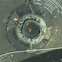
MAPS AND SIGNS CHEZ MICKEY I spent much of last week with maps of Disney's Magic Kingdom and Animal Kingdom in hand. For the most part, they were quite effective. I could find the number of the attraction nearby (say, Space Mountain), trace it back, by "land" (Tomorrowland, for example) and trace a route to another point of interest. Also on the map were other key locations including rest rooms and smoking areas. Disney has a policy that there is no smoking in the park, except at designated locations. Now, while I appreciate the notation of these "pit stops" on the map, I had no trouble finding a rest room without consulting the map. I attribute that to good signage and good locational choices by Disney. In the Magic Kingdom I also saw enough "smoking area" signs (circles with cigarettes in them) to steer clear of those areas. But, over at the Animal Kingdom, I got into trouble. I chose to sit down on a bench not far from a barbeque restaurant. On the bench across from me, a man lit a cigarette. I mentioned that there was no smoking in the park, except in designated areas. To his credit, he calmly explained that it was a designated area. I looked around, but saw no signage, and nothing big and obvious that let me know that I should avoid the area. The smoker pointed out that the garbage cans in the area had ashtrays on top. I'd not noticed that. So I approached a "cast member" (recall that all Disney employees are "cast members") and asked how I'd know where the smoking areas were. She pointed me to area from which I'd come: "You can smoke over there." I tried again: "How will I recognize the smoking area?" "They are on the map." "Oh, and how would I find them if I didn't happen to be looking at my map? Are there signs?" "No. We don't put up signs. We don't want you to smoke," she replied, a bit annoyed. When I tried to point out that perhaps that wasn't the best way to make both smokers and non-smokers happy, I was told to talk to the management. I've been thinking about this and realized a few things. First off, there are two ways to manage where certain behaviors happen. Either point out where the behavior is allowed, in places like designated smoking areas, or point out where it is not allowed, like the no-smoking section of a restaurant. I applaud Disney's choice to make the park a smoke free area. I'm also happy that they've set aside areas for smokers to do their thing. Another thing I've learned is that it's not enough, for me at least, to mark the "engage in this behavior here" signs on a map. I need real world indications (signs, colored benches, flashing lights) to warn me about these areas. I don't really want to travel through the "happiest place on earth," map-in-hand, picking out places to avoid. On the contrary, I enjoy Disney precisely because it's a "safe place." For example, if you are not tall enough, the staff won't let you ride on Space Mountain. And, as we all know, barricades keep you on the right path in winding attraction lines. Which brings me to the implication of the "cast member," that "smoke here" signs encourage smoking. Is that true? I have no idea. But, I will suggest that the signs lay out the ground rules fairly for both smokers and non-smokers, whether they are looking at a map or not. After my discussion with the cast member I kept my eyes open and did, in fact, find "smoke here" signs in the Animal Kingdom. But, unlike the area where I'd chosen to rest, which was out in the open, opposite a building with rest rooms and phones and next door to a restaurant, these other locations were a bit more hidden from view. You had to seek them out. One was behind a rather large rock formation and had at least one sign, on the main path, with an arrow indicating where it was. My message to the folks at Disney: Maps are not enough. Please post signs for locations where people can do things that you'd rather they didn't do, but do, in fact, allow on your property.
POINTS OF INTEREST � Several folks (thanks Matt and Larry) pointed to recent concerns about homemade GPS jamming plans now available on the Internet. An article in ComputerWorld explains that the plans are available in the online hacker magazine Phrack. Electronics and GPS professionals acknowledged that the plans should work. While the plans are specifically focused on jamming civilian signals, experts suggest the jammers could also affect military signals. The U.S. Department of Defense is said to have "anti jamming" technology on hand and Norman Maneta, U.S. Transportation Secretary last year suggested it be used for civilian GPS protection, too. � Autodesk just released final stats on Autodesk University, citing 3248 registered attendees, and 340 exhibitors. Next year's event will be at the MGM Grand Hotel and Conference Center in Las Vegas, from December 2-5, 2003. The registration website will open in July 2003. � About a year ago I reported on the idea of "memos hanging in space." Now, the BBC reports, a new idea is taking shape. The idea is to reserve the space, but provide the message on a mobile device. Several projects are now underway. One in Bristol (UK) highlights the history of slave trade there and has government funding. One in Los Angeles, California uses a laptop and headphones to mix art and local history. Annotate Space, an implementation around the Brooklyn, New York waterfront uses mid-air messaging in combination with a walking tour. There are still issues included how to "do" the locating and who owns the "airspace." � Geospatial technologies in Super Bowl ads: Bob Garfield reports in Ad Age about a Fed Ex ad that spoofs the film Castaway. After five years marooned, a FedEx employee delivers a package that he'd had the whole time. What's in it? A satellite phone, GPS locator, water purifier, and seeds. Garfield gave the ad 3.5 stars out of a possible 4. Interestingly, there were questions as to why the package did not include matches or a lighter. The answer: FedEx prohibits those from being shipped. Also, it's worth noting that FedEx was involved in the production of the film, which likely made getting permission for the spoof more straightforward. � The Sampson County Health Department, in Clinton, North Carolina, is upgrading its information technology infrastructure. Computer donations Pfizer Inc. and a software donation from ESRI are at the heart of the program, which helps grow health agencies' disease surveillance work and early identification of potential outbreaks. � Just to emphasize that geography does not always matter these days, consider Paul Thur. He works for Raytheon Polar Services Co., a subcontractor for the U.S. government's National Science Foundation, based at McMurdo Station in Antarctica. While he's down there, he's pursuing a certificate in GIS through the Penn State World Campus. � While announcing a strengthened Bentley Plant vertical organization this week at the daratechPLANT 2003 conference, Bentley also announced its earnings for 2002. Revenues rose by 14% to $230 million, while the company sustained and increased profitability, expanded its subscription licensing program, and invested in verticalization and several strategic acquisitions. � TenLinks reports that Autodesk will be merging Autodesk.com and Point A. There will be three levels of access: free content available to all visitors on autodesk.com, product-based content and services available to customers from links in products, and subscription content available only to Autodesk Subscription Program customers. AutoCAD Today, a webpage that pops up at the startup of AutoCAD, will be removed in future releases. I've suggested for some time that Point A was not very useful for GIS users. � MapInfo Corporation announced that it has been granted an Exhibitor Best Solutions Award at the Fourteenth Annual Government Technology Conference (GTC) Southwest 2003 for its solution developed for the Colorado Department of Corrections (DOC). More than twenty such awards were given out. A MapInfo representative explained the selection criteria: "Selected award winners were chosen based on a nomination form provided by GTC SW. GTC SW then reviewed the pool of candidates and chose based on the following criteria: a solution developed by a vendor for a specific customer to help solve a particular problem. The solution is NOT an "off-the-shelf" application but was created specifically for a customer or in partnership with a customer, either public or private. The solution must have resulted in significant benefits - saved time, money or headaches - and is worthy of recognition." � The New Haven Register reports that the state of Connecticut's consumer affairs chief urged lawmakers to outlaw the use of satellite technology to impose fines on rental car customers for moving violations. The proposal is in response to an incident where Acme Rent-A-Car imposed a fine based on GPS-tracked speeding. The company was ordered by the court to refund the imposed fines. The legislation does allow the use of GPS technology to track stolen rental vehicles.
� Announcements Intergraph Mapping and Geospatial Solutions, in collaboration with the Association of Geographic Information Laboratories for Europe (AGILE), announced a GeoMedia research grant opportunity for AGILE members. The grant is open to any member using or intending to use Intergraph's GeoMedia technology as the foundation for GIS research. The GeoMedia research grant will award $5,000 (U.S.) cash funding and a $50,000 software donation in recognition of an exceptional and innovative applied research proposal submitted by an AGILE member in an effort to further the implementation and evolution of GIS. Laser-Scan received certification to the new ISO9001:2000 standard. A new Ordnance Survey allows software developers to work not only with data for Great Britain, but also the rest of the British Isles including the Channel Islands under a single license. The Open GIS Consortium, Inc. (OGC) announced industry approval of an expanded version of the OpenGIS Catalog Service Implementation Specification. The OpenGIS Catalog Service Specification version 1.1.1 documents industry consensus regarding an open, standard interface to online catalogs for geographic information and web-accessible geoprocessing services. ORBIMAGE announced that it has signed a non-binding term sheet that will facilitate ORBIMAGE's prompt emergence from its Chapter 11 reorganization proceeding now pending in the Eastern District of Virginia. The agreement in principle includes the material terms for a settlement agreement to be submitted to the Bankruptcy Court for approval. Under the proposed settlement, ORBIMAGE would end its pending litigation with Orbital in exchange for additional working capital and other consideration to be provided by Orbital. Despite rumors about impending doom, Quova Inc., which offers technology that determines the location of a website visitor, announced it had raised $5 million in Series C financing from existing investors Mobius Venture Capital (formerly Softbank Venture Capital) of Mountain View, Calif., IDG Ventures of San Francisco and Nexus Group LLC of New York. The CEO says profitability is expected in the second half of the year. Laser-Scan and Intergraph Mapping and Geospatial Solutions have created a new interactive demonstration to show the capability of Radius Topology when working with GeoMedia WebMap Professional 5.0. Applications are currently being accepted for URISA's 2003 Exemplary Systems in Government (ESIG) Awards. The awards recognize exceptional achievements in the application of information technology that have improved the delivery and quality of government services. Trimble Navigation Ltd. expects to beat internal and analysts' fourth-quarter forecasts. The company anticipates fourth-quarter adjusted earnings of 26 cents to 27 cents per share on revenue of about $124 million. Intergraph Mapping and Geospatial Solutions' Cartographic Excellence Awards program is now accepting entries. The competition recognizes innovative, technically advanced mapping projects and Internet presentations created by cartographers and mapping professionals worldwide using Intergraph's mapping and geospatial solutions. Intergraph customers as well as students are invited to submit entries by April 1, 2003. The Delaware Spatial Data Implementation Team (I-Team) has posted a Request for Proposals (RFP) for a statewide LIDAR project to support the development of high-resolution elevation contours and updates to state flood hazard maps. The RFP calls for a statewide data collection program to be funded in parts if and when funding becomes available. Responses to the RFP are due by the end of the day on February 17, 2003. The Aleutian Group, LLC ("TAG") announces the acquisition and combination of Altex Technologies, a Swiss company, GeoDigital Technologies, LLC, a United States company, and Opten, a Russian company. The Aleutian Group specializes in data acquisition and data solutions for the Electric Utility, Railway, Pipeline, Forestry, and Fiber Optic Industries. It also addresses data and utility security concerns of government agencies. A new website, CarpoolTool.com, launched by a research group at the University of Waterloo, using DMTI Spatial data, aids commuters throughout Canada with the setup and management of carpools. Radio Satellite Integrators, Inc. (RSI), a global provider of customized GPS-based vehicle tracking and mobile data solutions, today announced the completion of an Automatic Vehicle Location (AVL) system for the Erie County Water Authority (ECWA) in Erie County, New York. @Road a provider of location-enhanced wireless Internet solutions for mobile resource management (MRM), announced the formation of a strategic alliance with TransDecisions, a developer of innovative logistics software for enterprises and transportation. According to the agreement, the two companies will work together to develop and market an integrated solution consisting of the @Road MRM service and TransDecisions' mobile logistics and scheduling system. Maporama, a provider of location-centric applications, and Danem, editor and re-seller of mobile software, announced today a new partnership to develop and market new generation mobile applications for companies managing mobile personnel in the retail and services industries. MapInfo awarded two homeland security grants. Deskmap Systems, Inc., has partnered with MapInfo to help the cities of Coleman and Marble Falls, Texas, begin implementing MapInfo's homeland security solutions. These solutions are an E-911 system and a nascent GIS system. � Contracts and Sales ESRI announced that Imagem Geosistemas E Comercio Ltda., one of its distributors in Brazil, is implementing a GIS at Ericsson Brazil. Getmapping plc won a contract worth more than �0.5 million from Ordnance Survey to photograph Scotland from the air. Polk County (Florida) commissioners voted to spend $324,085 over the next two years on Pictometry's imaging system. A �15m government contract to deliver a single public transport web portal for UK travelers has been awarded to a consortium led by U.S.-owned IT services company SchlumbergerSema. The company will head a consortium including UK firms Atkins, Real Time Enginerring, and ESRI (UK), as well as the BBC's commercial IT arm, BBC Technology, to develop a portal providing information and booking services for UK public transport services.
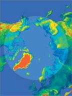
Vexcel Corporation announced a 2002 contract win with the National Imagery and Mapping Agency (NIMA) to develop technology that will map the region of land north of the earth's 60 degrees latitude. At right, a polar view of the area of land to be mapped. PlanGraphics, Inc. was recently awarded a contract to aid the City of Raleigh, North Carolina's Information Services Department, Geographic Information Services Division. The contract details the company's work to complete a GIS-based emergency response assessment and implementation plan to respond to natural, health, technological, or man-made emergencies. AirZip Inc. which provides a patent-pending compression technology, and ESRI announced an agreement in which � Products ESRI and Tadpole-Cartesia announced the release of a new computer-aided design (CAD) extension for ESRI's ArcPad 6.0.1. The extension provides native access to CAD data in the field along with cross-platform redlining functionality. Motorola, Inc. now offers to wireless carriers, auto manufacturers and other enterprises location-based services software that will deliver relevant, easily accessible information to consumers while they are mobile. Information delivered through the "ViaMoto" software can be customized depending on a consumer's personal preference. It will be available in virtually any environment, and will be available on a variety of wireless phones or other devices. Safe Software Inc. announced the availability of FME Suite 2003. FME Suite 2003 translates, transforms, and enhances sharing of data between more than 100 GIS, CAD, and database formats. Key new additions in FME 2003 mean that users can now easily merge large numbers of datasets, write to SVG (Scalable Vector Graphics), and reference a completely reworked on-line help system. Expanded format support now includes reading Autodesk Map Object Data and OS MasterMap V2 Address Layer, along with improved handling of generic XML and GML 2.1. This release also includes SDE versioning support and a .NET interface for FME Objects. 3D Nature LLC announced Visual Nature Studio 2 (VNS). VNS adds new capabilities and workflow improvements for GIS Professionals. Orders are being taken now and the product will begin shipping in January 2003. Mapopolis.Com, Inc. announced that the Mapopolis Map Pack for the Palm OS on CD-ROM became available for purchase beginning January 28th. The Mapopolis Map Pack contains maps of every U.S. road and major Canadian cities. The new CD makes carrying maps while traveling easier and makes the software available to users without Internet access. The new CDs are already available for pre-order from the company's website and will soon be available through retailers. Haestad Methods released WaterObjects an object-oriented application Software Development Kit (SDK). WaterObjects provides programmatic access to the features of the modeling software, enabling end-users and third-party developers to build, access, and modify model databases to suit application-specific needs. Corda Technologies Inc. has announced a new product called OptiMap. OptiMap is a charting solution for creating dynamic Web-based maps. The resulting maps can integrate and display data from multiple databases. According to MacCentral, OptiMap creates data visualization solutions that are purportedly less expensive to generate than traditional GIS maps. SGCi Penobscot Bay Media, an ESRI Business Partner, announced the release of SGCAtlas, an extension for fully-automated map-series production and printing for the ArcGIS platform. A 30-day FREE trial may be downloaded. eSpatial announced the release of iSmart 4.0, the latest release of the spatial application development environment. The iSmart Product Suite supports the consolidation of disparate spatial and business data sets, their integration with the wider IT infrastructure, and the distribution of spatial and business data to both web and GIS clients. As such it provides a complete solution for developing enterprise spatial applications on Oracle. � Events Azteca Systems, Inc. will host its third annual Cityworks User Conference, June 4-6, 2003, in Park City, Utah. The User Conference is open to all Cityworks software users with current Update & Support or paid registration. This annual event draws upwards of 200 attendees and exhibitors from across the country and internationally, along with Business Partners and potential customers. � Education and Training � Hires and Appointments Woolpert LLP mourns the tragic loss of (Forrest) Steve DeMartino, killed in an airplane crash on January 8, 2003, in Charlotte, N.C. He was traveling to the Greenville-Spartanburg Airport on company business when his plane crashed shortly after takeoff. DeMartino managed the application development and project management groups for Woolpert's geographic information services division. Analytical Surveys, Inc. ("ASI") announced the appointment of Lori A. Jones to the position of Chief Financial Officer.
ADVERTISE WITH US
CONTACT
SUBSCRIBE/UNSUBSCRIBE |