Letters, Points of Interest, Week in Review, Back Issues, Advertise, Contact, Subscribe/Unsubscribe
FINDING AND MAPPING SHUTTLE DEBRIS: A REPORT FROM THE FIELD Editor's note: David Allen, GIS Manager at the City of Euless, Texas shared his experiences on the ground aiding in the Columbia debris mapping and collection. I appreciate his contribution in the field and his willingness to share his story, which follows. On Tuesday, Feb 4th, a call went out for GPS operators to report to the Forest Resources Institute (FRI) at Stephen F. Austin University in Nacogdoches, Texas. About 40 GPS operators with equipment showed up the next day. Some were deployed to San Augustine County and some to Nacogdoches County. There were three ways that debris was being found. Two of the methods involved helicopter surveys. On Saturday and Sunday, NASA had done flyovers in a helicopter to look for debris. Large pieces spotted from the air were photographed and later plotted on digital orthophotos. Analysts extracted long/lat coordinates and entered them into a GPS unit. Searches on the ground in the area would use GPS to navigate to the piece. Some of the large tanks and structural parts were found this way. I read a story that [Space Imaging's] IKONOS had provided satellite imagery from about 3 hours after the disaster, but we never saw these images in the field teams. Instead, we worked from images produced by the State of Texas Department of Information Resources in 1997. They flew the entire state and provide these free on the Internet. The FRI lab was experienced in using these images and had them on hand. Also from the flyovers, they were able to spot areas of concentrated debris. These areas were located on the digital orthophotos and 1000-meter search grids were laid out. Surveyors were sent into the field to mark the corners of the search grids, then searchers were deployed to those areas to do a systematic walk-through. I was on this team for 4 days. We would form a line about 20 people long, spaced about 15 to 20 feet apart. Then we would walk the search area, picking up debris. Then we would move the line over and sweep a new area. It was slow and the brush was very thick, but we were surprisingly thorough. This type of searching is ongoing. The third way that they were finding debris was through the 1-800 number shown on the news. People would call in a report and the information would be taken down. Then a Department of Public Safety (DPS) State Trooper and a GPS operator would drive out to the site to gather information and collect the debris. This was a cushy job for the GPS operators because you got to ride in a heated car instead of slogging through the thicket in the rain and sleet. I got to do this on my last day of searching. Originally the call was for sub-meter GPS units, but we soon discovered that the tall pines were blocking too much signal to get a good reading. Handheld Garmin and Magellan units were doing fine in the tree cover. A representative from Trimble, onsite to provide technical assistance, explained that the sub-meter units filter out weak and reflected signals so that the units can achieve the desired accuracy. Since the less accurate handheld units aren't as discriminating, they will use "bad signals" to find a location. The Trimble GeoExplorers were performing very well because they have a sliding scale that can be used to control the signal filtering. It goes from "Productivity" to "Precision". We could set these about halfway up the scale and get 5-meter readings in the thicket, much better than the 30-meter readings we were getting from the Garmins and Magellans. The bottom line was that although these units weren't as accurate, they were more practical. These less accurate units are now in full deployment. The search teams have them and all DPS Troopers have them. By Saturday, Feb 8th, the need for GPS units had been met. [The editor notes: An article in the Fort Wayne News-Sentinel explains that the higher end GPS receivers', "level of accuracy wasn't needed for the grid boundaries, so the Fort Wayne surveyors borrowed from Texas colleagues' more mobile GPS equipment that could locate a position within 3 meters."] The Forest Resources Institute and the Hues GIS Lab (both at Stephen F. Austin University) have been working with NASA, the FBI, and the NTSB to plot all the debris. Eventually, this can be used to create an animation of how the pieces fell. But, right now they are looking at the concentrations of debris not to see what's there, but what's missing. If they see that one search area contains debris mostly from the rear of the Shuttle, then they can look at an inventory of hazardous parts and see what hasn't been found. That information, in turn, will be used to alert the field teams to search for those types of parts. The Shuttle carried a surprising amount of hazardous materials. In the morning briefings, they would show us photos of tanks, cylinders, bolts, panels, etc., that either contained some nasty chemicals or were explosive. A fuel cell had been found in our area and we did find many explosive bolts. Mostly, we were finding structural pieces and tiles, all scorched from re-entry. Nacogdoches County Deputy Tim Burton led my crew. He let us know what was expected from us, and we all worked hard. The group was comprised of law enforcement personnel, fire department personnel, and specialty technical people like GPS and HAM radio operators. Because of that, we were a more disciplined team than some of the teams that went out comprised mostly of local civilians. It was an honor to be included on Deputy Burton's team. We were diligent in our efforts; and although it was very hard work we all felt that the job we were doing was very important, not only to NASA, but to the families of the astronauts. The FEMA command post in Nacogdoches is no longer seeking volunteers. The forestry service has sent their emergency response team that normally deals with forest fires to the site, so they have about 1200 people on the ground.
MORE ON COLUMBIA MAPPING An article from The Colony Courier-Leader had this quote from the Colony's GIS Coordinator: "'Part of the shuttle recovery project is to map the location of debris,' he said. 'The more accurately they could plot the debris the better, so they put out a request for help from anyone with (Global Positioning Satellite) equipment capable of sub-meter accuracy and the expertise to go along with it.'" GPS was correctly written out as Global Positioning System, just one paragraph above. The Orlando Sentinel in an article about the contributions of the Stephen F. Austin State University's Forest Resources Institute notes, "The Forest Resources Institute already had been using much of the Global Information System technology to create detailed analyses of the very forests into which much of the shuttle debris disappeared."
GIS AND LOBBYING Also in the lobbying department, I read of Dean Kamen, inventor of the Segway "scooter" who, according to Wired, hired scores of lobbyists who went out to convince state legislatures to rewrite their laws to permit his scooter to operate on their sidewalks. This made me think about lobbying in general and lobbying with regard to geospatial technology in particular. I confess that lobbying and GIS never meant much to me until I was at an OGC meeting where the head of the Spatial Technology Information Association (STIA) gave a presentation. STIA is a lobbying group. Then, I got invited to the Management Association for Private Photogrammetric Surveyors (MAPPS) lunch at the ASPRS conference last spring and learned that they are a very effective lobbying group, though they use the term "advocacy" on the organization's website. Recall too, that at National States Geographic Information Council (NSGIC) meeting last fall, STIA lead Fred Corle joined Jack Dangermond in suggesting an aggressive push for geospatial to Congress. I don't know if anything came of that. And of course, there is more personal lobbying, such as Dan Elroi describes in his newsletter about a trip to Capitol Hill. Do other GIS related organizations take on advocacy roles? GITA now has a GeoSpatial Leadership Coalition (GLC) that tries to weave organizations together and push forward a National Spatial Data Infrastructure (NSDI). The Federal Geographic Data Committee (FGDC) provided funding for GLC. URISA, to date, has focused on educating its own users, rather than on policy per se. Still, initiatives have focused on the role of surveyors, privacy, and addressing issues. The Open GIS Consortium (OGC) focuses on interoperability, and has not actively lobbied on any issues. The organization is however a member of STIA. Much advocacy in the geospatial arena, I think, is coming from the NaCOs and NSGICs of the world. While these organizations mostly serve members, they also take stands. NaCO, while not explicitly a geospatial organization, has goals that include ensuring "that the nation's 3066 counties are heard and understood in the White House and the halls of Congress." After a few years of building GIS awareness (including an extensive GIS grant program) NaCO has a policy statement on GIS Interoperability. NSGIC's website notes that organization's commitment to NSDI, but also says, "NSGIC reviews legislative and agency actions, promotes positive legislative actions, and provides advice to public and private decision-makers."
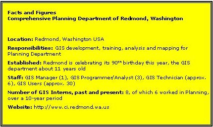
The organization I want to introduce is the Comprehensive Planning Department of Redmond, Washington. Kim Dietz is a GIS Programmer/Analyst who's been with the department for 6 years. Dietz knows all about interns. She started her career as one in the City of Allentown, Pennsylvania, eventually becoming the GIS Coordinator for that city. I asked Dietz to share some of her experiences with, and observations about, interns. You suggested that many BS geography graduates in your area don't yet have all the skills needed to step into an entry-level GIS job. Many return to community colleges for further study. Why is that? What do they study at the community college? Undergraduate students have the book knowledge but lack to tools to apply it. They may only understand the "how-to" when they obtain "hands-on." That experience is typically gained through certificate programs provided at the community college or extension programs of statewide institutions. Those students with some "hands on" behind them often become interns with your department. When you hire students from the community college as interns, what type of work do you have them do? I put them to work immediately, on their own, with inventories and data development. Typically they work with geographic data and participate in the full design of data structures and the population of the resulting database. How do you manage interns? Do they work alongside full-time employees? Do they have extra supervision? I want the intern to work alongside me. I do not have the time, within a normal 6-month internship, to train on the steps of using software. Interns become fulltime members of staff and are expected to attend weekly division meetings and deliver status reports on their projects. They are allowed and encouraged to take ownership of their work. At Redmond, I have offered interns projects such as street annotation development, annexation history inventory, and shoreline bulkhead inventory that included sunny, summer kayak trips. None of this information was previously available within the City's GIS data banks. Currently we combine the internship program within the Planning department to be that of a Planner with GIS experience. The success rate is astounding with these individuals participating at the public outreach level and acting as key elements in presentations to the general public as well as the Planning Commission and City Council. I understand that you invite your interns to join you at local GIS group meetings and introduce them to prospective employees in the public sector. When did you begin doing that? How are the results? Do you recommend this over using the Web or other methods for finding permanent employment? When interns express their wishes to continue in GIS and to seek employment in the local market, I suggest one method. I invite them to attend a Central Puget Sound GIS Users Group (CPSUG) meeting and to introduce themselves along with a short presentation of project deliverables, including maps. CPSUG was founded by the first President of NWCAMA, now WAURISA, and has been up and running for more than three years, with more than 300 members. Regularly scheduled monthly meetings bring together between 30 to 60 members for presentations, workshops and demonstrations. Because CPSUG, along with other area associations, has over the years provided ample venues in which members get to know each other, a tight family style network has been generated. The new interns or graduating students must find a role for themselves in this family and in a limited market. Having spent several years with this user group and two years on the board of WAURISA, I have again and again preached that those interested in breaking into the field of GIS must simply "get out there" in any manner that they may find or create for themselves. Repeatedly, I have offered various positions to those that inquire so that they may establish themselves with a portfolio of work examples and make their face/name known in a small community. Therefore, the items of advice that I would present to any graduating class of GISers is to offer their services in the communities of their interests, become members of associations, attend all possible gatherings, and do some type of work for free. Yes, none of this will pay off the school loan but it will open the doors to a career of satisfaction and a multitude of choices. And finally, get hands-on experience. Even if you do it on your own with free software and free data in your basement at night - it counts! And I'll hire you simply for ingenuity. Have you kept interns on in your department or do they move on? My position was created from an intern position. This occurred prior to my joining the City, but 3 interns filled the role before 1997. Since then I have worked with 3 interns who have succeeded in obtaining full-time positions locally. How might the GIS education system change so that the extra step of community college study might be avoided? I feel strongly that internships should be required during the 4th year. However, extra work needs to be taken by the student to acquire the necessary tool kits or hands-on skills. It might be possible for those students to obtain or even create roles in which they are learning and using desktop GIS. Volunteer positions are readily available if one performs the necessary research and makes the correct connections. This is becoming more and more important in a limited market. Jobs do not magically open since GISers of today are not quite ready to retire or to leave. Some people in this local region have simply thought-up a use for GIS, found the software through begging or free downloads, and then started generating a product. Entrepreneurs or basement hermits, it is these people that are now managing fully functioning businesses and delivering quality products each day, even though they could not find a job upon graduation.
Do you work for an Innovative Organization that should be profiled here? Drop me an e-mail explaining why. Barbara B. Cooper, LPLS at Hawaii Electric Light Company, explained that while Hawaii is a paradise, the schools could use some help. The two volumes are on their way to Hawaii, from the two feet of snow here in Boston.
LETTERS "I read with interest the article on marketing GIS. It's a tough sell, I'll tell you that, and the ideas expressed in the article are interesting. However, to really understand 'selling the invisible' whoever wrote the article should read Harry Beckwith's books." The editor notes: Just to be clear, I wrote the article in GIS Monitor. Charles Stein wrote the original article in the Boston Globe. And, I used my holiday Amazon gift certificate to get Mr. Beckwith's book. � Alvin L. Hanks, Principal at Chesapeake Analytics Corporation, also had some additions to the marketing article. "Excellent article, and I would generally agree with your five key points as central issues to be understood in marketing, I would suggest a couple of other variables. "1. There has long been a mantra in marketing called 'focus,' although perhaps not well understood. Superficially it says stay tuned in and don't become distracted. The real reason to focus is because to really understand your market you need many details about: the buyer (customer profile), budgeting cycle, business processes, technical matters including particular language/terms, etc. The simple fact is it's hard to keep track of these varied but relevant details for more than 3-4 market sub-sectors. Thus 'focus.' (Although nothing's perfect, e.g., IBM almost lost the PC market by 'focusing' on big iron.) "2. I also like to use a model I learned from the writings of Gary Hamel and C. K Prahalad, CF Competing for the Future, Harvard BSchool Press 1994. Of particular interest is their discussion (in subsequent papers) of 'intersections of change.' The thesis here is that by viewing and understanding trends in certain related arenas one can 'see the future first.' Specifically in the GIS and spatial data industry, we are particularly affected by trends in: enabling technology, government regulation, geopolitical issues (e.g. off-shore labor costs), demographics, general economic conditions, etc. Understanding drivers and trends in these areas gives us the best opportunity to predict market trends in GIS. "3. Jack Dangermond likes to discuss the evolution of GIS from the individual, to projects, to the enterprise and eventually to societal GIS. I suggested to Jack that this reminded me of running shoes. The simple analogy is to any product that becomes generally adapted to a mass market, going from a small group of users to a broad consumer based demand. The bell curve description of a market's rate of adaptation best illustrates this, as the obvious large demand, read 'dollars,' is the central part of the curve. The market will grow as the various uses and applications of GIS evolve into the society at large. "4. For a discussion of the role that the Internet might play in the GIS industry please see my paper An eCommerce Business Strategy is not Necessary, It's Mandatory, published in the proceedings of the ASPRS St. Louis conference."
POINTS OF INTEREST � A BBC article suggests that congestion at the rings edge will drive down housing prices. Meanwhile, those who live in the ring will capitalize on a 90% discount on the charge. All the gory details about the boundary, how to pay (phone, text messaging, convenience stores) and who gets a break (busses, the disabled, emergency vehicles, etc.) are provided at the BBC. � Woz knows geography matters. Wired reports that Steve Wozniak, aka Woz, co-founder of Apple and current CEO of Wheels of Zeus is moving because his existing home is in a wireless dead zone. He's moving across town, to another property he owns, which has GSM reception. � Anthony J. Pryor, who's Godseye project is now tied into GeoURL (mentioned in GIS Monitor a few weeks ago), has its roots at ArsDigita University, an experimental school put together by an MIT professor, Philip Greenspun. Godseye is another attempt to weave geography into the Internet and search engines. While I applaud the creativity, without an open standard, I don't expect this type of work to take off in any meaningful way. � Bentley's added an afternoon session to many of its World Tour dates. The session focuses on Building Information Modeling (BIM), what the company calls the next evolution of CAD for the building industry. BIM, Bentley suggests, is upgrading the way that architects, engineers, contractors, and facility managers work and collaborate. I'll share what I learned at the Bentley World Tour event in Boston next week. � I erred in reporting on Leica's new Airborne Laser Scanner. The new model is the ALS50. I apologize for the error. � The Seattle Post-Intelligencer reports that Lizardtech laid off about ten employees, including the vice president of engineering and vice president of business development this week. That brings the company down to 38 employees from a high of 200 in 2001. The company has raised more than $40 million in venture capital since its launch in 1992. � The New York Times describes a prototype "personal awareness assistant" - a wearable computer with microphones, earbuds, and a GPS. The idea is to save conversations, time and location stamp them for future use. The most interesting fact from the article, "The average person probably speaks for only about 10 minutes a day," Dana Le, an Accenture researcher said. "You could record your entire audio life on a couple of terabytes." � A federal judge in Albany, N.Y. granted SRC the right to have indpendent auditor examine MapInfo's books to investigate whether the company paid appropriate fees to SRC. Since the lawsuit and countersuit filed in November, the judge dismissed two claims and part of a third claim. SRC dropped one voluntarily. Discovery is expected to end in April. � The Albany Business Review reported on the MapInfo stockholders meeting in Troy on Wednesday. Basically, CEO Cattini asked investors to stick with the company through these rough times. Chairman Cavalier pleaded, "Bear with us, give us some slack. We won't let you down." The company does have one thing going for it: many of its competitors are fading. The article points out that where once MapInfo had 13 competitors for the likes of a Vodafone contract, now there are three or four. � This bit of "geography elimination" comes from The Harrow Report (thanks to Jim for recommending it). It turns out you can upload your digital pictures to the Wal-Mart website, and have them printed at whichever store in the country you'd like. I think Kinkos and other printing chains do that, too, but this solution is very consumer friendly. Where else might this lead? � Quote of the Week: Phil Young, an Northern Illinois Research scientist in geography who's heading up the management of a $900,000 value grant from Intergraph, looks at the grant this way. "It's not really selling out. The fact that we bear that name doesn't mean we carry just their software. They are giving us something that we couldn't afford to get on our own. We would be doing the research anyway. We consider ourselves software neutral. We don't say one piece of software is better than another."
� Announcements The Open GIS Consortium's (OGC) biennial election of directors has been completed. Newly elected directors are Jeffrey K. Harris, Deputy, Space Systems Company, Lockheed Martin; Mr. Bert J. Jarreau, Chief Technology Officer, National Association of Counties; Roberta Balstad Miller, Director, Center for International Earth Science Information Network (CIESIN), and Senior Research Scientist, Columbia University; Dr. Robert Moses, President and CEO, PCI Geomatics; and Mr. James R. O'Neill, TASC President, Northrop Grumman Information Technology. The Open GIS Consortium, Inc. (OGC) recently presented the U.S. Army Corps of Engineers (USACE) with the first annual OGC Vision Award. Lt. Gen. Robert B. Flowers, Commanding General of the USACE, accepted the award. This award recognizes the outstanding contribution the USACE has made to the organization and growth of OGC, an international public/private partnership working to make geographic information and services openly accessible across multiple platforms and devices. Editor and Publisher reports that the New York Times Syndicate is planning to launch the National Geographic Map Service. But first, the Syndicate is offering a special package of five maps tied to the possible war with Iraq. Two intelligence agencies will this week begin beta testing a solution from MetaCarta and ESRI. Government Computer News reports the unnamed product went beta development last week and will ship in March. MetaCarta and ESRI announced a relationship last week. URISA has approved a slate for officers for election. Some top-notch folks are in the running for president: Kathrine Cargo, GIS Project Manager for the Orleans Parish Communications District in New Orleans, Louisiana; Thomas Conry, GIS Manager for Fairfax County, Virginia; Fred Halfen, Regional Vice President of Ayres Associates in Madison, Wisconsin; Steve Kinzy, Regional Manager of ESRI's St. Louis Office in St Charles, Missouri; Susan Carson Lambert, Intergovernmental Advisor for the U.S. Geological Survey in Frankfort, Kentucky; and Lisa Lubeley, GIS Manager for the City of Escondido (California) Engineering Department. URISA members will be mailed the 2003 election ballot in May, with each candidate's position statement and vision for URISA, with completed ballots due at URISA Headquarters by June 27, 2003. Indus International, Inc. a provider of enterprise asset management (EAM) solutions, announced it has entered into a definitive agreement to acquire the Global Energy and Utility Solutions (GEUS) business unit of Systems & Computer Technology Corporation. The Commonwealth of Virginia began initial distribution of high-resolution digital orthophotography products created under the Virginia Base Mapping Program (VBMP) to counties and cities across the state. The VBMP orthophotography contract is being managed for the Virginia Geographic Information Network (VGIN) by VARGIS, of Herndon, VA. The orthophotography product will be licensed to all governments and public sector organizations in Virginia at no cost. Several announcements were made at a recent meeting of Ordnance Survey and its partners. All partners will be invited to join a dedicated communications channel to enhance the development of products and the management of product lifecycles. Ordnance Survey is also offering its partners more Web-based services, enhanced pre- and post-sales support, and the opportunity to be accredited consultants. Metamend announced it has created an address extraction technology that can read a website, extract geographical data, then determine if the website has a relevant physical presence as well as an online one. This is basically Laser-Scan signed a Memorandum of Understanding (MOU) with leading professional services consulting firm, Sinclair Knight Merz (SKM) to develop its presence in Australia. IDELIX Software Inc.'s management and shareholders have committed 50,000 options at $0.70 per share to Science World, a science museum in British Columbia. The gift is tax deductible. Brian Lantz, vice president and advisor of homeland security for MapInfo was recognized as one of Fast Company magazine's "Fast 50" Champions of Innovation for efforts that led to the creation of MapInfo's Homeland Security Program. Winners are selected from online submissions by Fast Company readers. Visual Studio Magazine presented its annual Readers' Choice Awards Monday during Fawcette Technical Publications VSLive! 2003 San Francisco conference. These awards, chosen by Visual Studio Magazine's readers, included a win for ESRI's MapObjects which took the Imaging & Graphics Readers' Choice Award. SoftStar and OleMap have launched a mobile location-based game, @ Life, with FITEL, Taiwan. The aim of the game is for players to achieve the ultimate goal of being a millionaire. Location becomes a key theme of the games, as different locations will affect player's ability in attaining his or her goals, such as where to eat and where to work. Gee-just like real life! PlanGraphics, Inc. reported a net loss of $291,257 on revenue of $1,649,639 for the quarter ended December 31, 2002, as compared with net income of $37,934 on $2,120,218 a year prior. Analytical Surveys, Inc. (ASI) announced financial results for its first fiscal quarter ended December 31, 2002. First quarter revenues were $4.3 million versus $5.6 million in the same period a year ago. The Company reported a first quarter net loss available to common shareholders of $817,000, or 99 cents per diluted share, versus net earnings of $4.0 million, or $5.80 per diluted share, in the first quarter last year. MapInfo announced that MapInfo miAware 2.0, a mobile location services platform, adheres to Mobile Location Protocol specifications set by the Location Interoperability Forum (LIF), which is now part of the Open Mobile Alliance (OMA). The product also supports the Open GIS Consortium's OpenLS-proposed specifications. MapInfo has a statement about the Slammer virus on its website. The International Journal of Health Geographics has just published TerraSeer's study of cancer patterns on Long Island, New York. The studies include the application of several statistical approaches, including one new one--polygon wombling. Researchers found no relationship between air toxics and breast and colorectal cancer, but there was a significant spatial association between exposure to air toxics that are known to cause lung cancer with the pattern of lung cancer cases. Intergraph Mapping and Geospatial Solutions and the Intergraph GeoSpatial Users Community (IGUC) today announced the inaugural Geospatial Achievement Awards program. The worldwide competition recognizes Intergraph users for use of GIS in government, military, transportation, utilities, and application programming areas. Microsoft announced that MapPoint mobile partners (Intrado, Action Engine, Clarity and HP) have built LBS services with MapPoint .NET. These will be shown at the upcoming 3GSM World Congress. SiRF Technology, Inc. announced it has signed a definitive agreement to acquire Enuvis, Inc. SiRF is particularly interested in the company's patented UrbanGPS Assisted-GPS (A-GPS) technology. Leica Geosystems and Loyola Enterprises announced a distribution agreement for the sale and service of Leica Geosystems' GPS/GIS and GPS Reference Station products in Virginia. The AP reports that Ivan Getting and Bradford Parkinson received the Charles Stark Draper Prize for inventing and implementing GPS. The engineering prize is its field's equivalent of the Nobel Prize. � Contracts Wanadoo, a French ISP, selected Tele Atlas as the map data provider for its portals and its nearly nine million active customers. The deal with Wanadoo Maps makes Tele Atlas the leading map supplier to the French Internet market. The U.S. Federal Communications Commission (FCC) made few changes to its rules for the use of UWB (ultrawideband) technology after considering some petitions for change. One suggested the technology would interfere with GPS signals. Spot Image, a French company operating the SPOT satellites, has signed a channel partnership agreement with IMAGEM granting it exclusive rights to market SPOT products and services in Brazil. According to Mark Cittani, MapInfo's CEO the Australian Capitol Territory Emergency Services Bureau (ESB) and the New South Wales Rural Fire Service (RFS) will soon adopt a MapInfo-created bushfire-modelling system. The system relays data gathered from aerial surveys to bushfire crews on the ground via mobile devices such as cellular phones. Geographic Data Technology, Inc. announced it has been selected as the prime source of mapping information for Appian Logistics Software Inc.'s route planning and geocoding software and services. � Products TruePosition is shipping its new location product, based on U-TDOA (Uplink Time Difference of Arrival) called "The Finder." This location methodology relies on technology located in cellular operator base stations, and determines a mobile phone's location by precisely measuring and then comparing the exact time at which a cellular signal reaches each of the stations. By providing location technology to wireless carriers in 12 cities, TruePosition is leading the largest deployment in the United States of location technologies in support of the United States' enhanced 9-1-1 mandate. MapInfo Corporation and Ordnance Survey announced MapInfo HealthPro, a product to help Primary Care Trusts (PCTs), Strategic Health Authorities, Regional Health Authorities and Health Observatories meet the government's NHS modernization targets. HealthPro will be available in March 2003. Hitachi Software Global Technology, Ltd. (HSGT) announced the release of its updated CAD Client for Version 2.6 of its GIS platform, Any*GIS. Bentley Systems, Incorporated, announced the release of its V8 Generation products, some 100 of them. The company also announced its "Power" Products, build on it PowerDraft, 2D platform. The first product out is PowerMap which includes a range of editing, clean-up, and thematic mapping tools, file import for a range of common geo-oriented formats, flexible coordinate system support, automated reference file transformation, and integrated high performance imaging. Bentley PowerMap offers ODBC connectivity as well as querying of Oracle Locator/Spatial data. No details on how this product works with MicroStation Geographics were available. I vaguely recall Bentley mentioning a "lower end" vertical line some years ago. A limited edition Iraq Planning Map has just been published by the United States National Imagery and Mapping Agency (NIMA), and is available through CMT announced the release of The National Imagery and Mapping Agency (NIMA) released to the public three special reference maps of Baghdad, Iraq, and the Middle East. NIMA produced these maps as tools to help its public affairs office and other government public affairs offices in their efforts to discuss issues with the media and public that might be related to the areas depicted. Hardcopies will be available after February 24 through USGS. Tele Atlas and Wayfinder provide an off-board, up-to-date navigation solution. Voice instructions, pictures, and maps guide the user as he drives or walks. Intergraph Mapping and Geospatial Solutions announced Version 5.1 of the GeoMedia product suite which will add enhanced capture and editing functionality, batch plotting, and advanced layout tools, enterprise-wide style guide support, Tablet PC support, and enhanced Oracle support. The enhanced GeoMedia suite of products for the desktop and the Web will be available during the first half of 2003. Intergraph is now shipping version 5.1 of GeoMedia and GeoMedia Professional. DMTI Spatial released CanMap Streetfiles V7.0 and CanMap RouteLogistics V7.0. Data Directions announced the release of its MapInfo extension, Workspace Catalog, a workspace management tool. A free demo is available. GenaWare announced planned support for the GenaMap suite of spatial tools and core GIS software on Linux ready IBM eServer pSeries systems. WIND, a mobile provider in Italy, has announced a WAP GPRS mapping service. It provides color maps, directions and searches for businesses. The service costs 4 cents per Kbyte downloaded, including tax. In addition, for subscribers, there is a 15 percent discount for more than 10 Kbytes downloaded in a single connection. ImageLinks announced the availability of its TrueTerrain visualization/simulation data sets covering five of the world's current areas of political interest - Iraq, Afghanistan, Turkey, Qatar, and the Korean Peninsula. Maptech now offers two solutions to get maps on to a handheld which hosts a GPS. Outdoor Navigator allows downloads from a collection of more than 62,000 USGS topo maps and NOAA nautical charts. It's a subscription solution. Pocket Navigator works with Maptech CD-ROMs (Terrain Navigator (topo maps) or Digital ChartKit (nautical charts)) and allows download to the devices from a CD. Both products support Palm and PocketPC devices. The company also offers GPS hardware. Autodesk Location Services, a division of Autodesk, Inc. announced the fourth major release of Autodesk LocationLogic, a carrier-class software platform for location-based services (LBS). Tennessee Wildlife Resources Agency data is now downloadable. � Events URISA and the IAAO wiill host the 7th Annual Integrating GIS & CAMA Conference in Columbus, Ohio, March 30-April 2, 2003. Early registration ends March 12. ESRI will host its annual Business Partner Conference on March 22-25, 2003, at the Wyndham Hotel and Palm Springs Convention Center in Palm Springs, California. � Education ESRI is offering workshops to highlight new features that ArcGIS 8.3 gives to ArcEditor and ArcInfo users. The day-long workshops will be held across the United States in March and April. There is a fee to attend. ImageSat offers high-resolution (1.8m) panchromatic images for free to Universities and Research - one per project for selected projects. � Hires and Appointments GeoConcept SA, European leader in Geographic Information Systems (GIS), announces today the opening of GeoConcept International Software SA Switzerland, its Swiss subsidiary. eSpatial announced the appointment of David Miller as chief operating officer (COO) at the company. Mr. Miller joins eSpatial from Sepro Telecom, where he held the position of Chief Operating Officer and Chief Technology Officer. Matt Davis has been appointed Assistant Regional Office Manager at ESRI-Boston. Davis returns to ESRI after working for EMERGE for several years as General Manager.
ADVERTISE WITH US
CONTACT
SUBSCRIBE/UNSUBSCRIBE |