Letters, Points of Interest, Week in Review, Back Issues, Advertise, Contact, Subscribe/Unsubscribe
AUTODESK'S TAKE ON LIFECYCLES A few themes ran through the conversation. One is the idea of lifecycles. Autodesk is taking a hard look at project lifecycles and developing products to address them. Autodesk historically focused on design, but six years ago expanded its offerings to support GIS. Autodesk also is integrating its "point products," those aimed at a single task in a workflow, into groups that connect what came before and what comes next. The idea is to have a set of solutions that serves the entire lifecycle of a project where intelligence (design, spatial, or otherwise) is correctly passed along. One realization from exploring the current workflows and lifecycles is that managers receive "bad data." This is not intended, of course, but the movement of the data has, in the past, allowed key information to "slip out." The new vision is to ensure that it does not. The new solution, termed Infrastructure Lifecycle Management, is an end-to-end series of linked products that insures proper management. Part of the business logic is based on the fact that design is 10% of an asset's value. Autodesk should know; it has provided design solutions for more than 20 years. Now, with so many new roads, bridges, and buildings constructed and in use, it's clear that owners are not happy, and those who maintain the infrastructure are not happy. That's the impetus for taking a step back to explore and support the entire process with new, linked products and services. What sort of infrastructure does Autodesk have in mind? The assets of governments, telecommunication and utility companies, and civil engineering and general construction firms. The underlying needs are the same, though the ultimate tools and interfaces may be quite different. Having come from the design side of Autodesk, Bradshaw uses an anecdote from government. The $900 toilet seat that made headlines a few years ago may have been due to miscommunication and the "recreation of the wheel." Instead of using an existing component, or existing research, someone tried to start from scratch. The key concept here is to recognize that firms are optimizing design for the lowest cost of total ownership. They are factoring in the cost of management, operations, and maintenance during the planning and design phase - not unlike the transformation that the manufacturing industry has undergone over the last two decades. They want to be able to reuse the planning and design data that is created for the construction phase after construction is complete - that is, during management, operations and maintenance. Think about a bridge retrofit project - the cost of recreating the as-built drawings, re-analyzing the structural loads, and reviewing rights of way are all costs that can be eliminated by having a system that retains and tracks this information and ensures that it is accurate and precise at project completion. In the geospatial disciplines we want to avoid the $900 toilet seat. Some of our raw data may come from surveyors. These data may be in the form of maps and documents. In essence, to be sure that we use the right information and re-use it intelligently, what is needed is the "marriage of maps with a document management system." This provides a queryable and workable solution to get at key information, something that might have been missing in the past. Autodesk, according to Bradshaw, is uniquely positioned to make this vision a reality. Part of the solution is Bradshaw's old stomping grounds: Buzzsaw, Autodesk's online collaboration solution that makes documents available, queriable and secure. And, since the lifecycle of infrastructure can run as long as or longer than a building, long term secure access is essential. The economy, Bradshaw suggests, is on Autodesk's side in this vision. Investment from both the public and private sectors is slow. The Autodesk focus on management throughout the life cycle that Bradshaw offers provides assurance to those willing to take risks - including investors, owners and designers. Non-adopters of these tools, he expects, will be left behind. After discussing this vision, which sounds remarkably similar to the one Bentley offered during its World Tour with its managed environment, the discussion turned to some specific questions about the state of GIS at Autodesk. I understand that the GIS Division is now ISD, Infrastructure Solutions Division. Why the change? Does the Division still cover the same products and markets? GIS didn't accurately describe operations, and didn't serve Autodesk or its clients well. Infrastructure Solutions Division more accurately describes the broad and complete set of solutions that reach engineers, surveyors and infrastructure management professionals, as well as GIS professionals and those whom Autodesk already serves. GIS is a critical part of these solutions. We still offer the same products, but our new name reflects the broader audience. I understand that while you've been at Autodesk for some time, you are not a "GIS guy." How do you plan to leverage your experience with a technology that's new to you?
I've been at Autodesk since 1991, and have been involved in AutoCAD business management, AutoCAD product management, AutoCAD LT, AutoCAD R14, and sales in Asia/Pacific. I was at Buzzsaw from Oct 1, 2001 until now. Although not in the GIS arena, I have spent the past twelve years immersed in how to help our customers improve business efficiencies and increase the value of their digital data. I understand the project lifecycle and how GIS professionals, engineers, surveyors and infrastructure management professionals, need to create, analyze and share data while maintaining precision and accuracy. I'm surrounded by an extremely talented, well-seasoned team of GIS veterans. What do you see as Autodesk's biggest challenge in GIS/Infrastructure Solutions? I think the biggest challenge is education - educating the industry on the benefits of leveraging design and project data across the lifecycle of a project and across the enterprise. The fact is that the technology is largely in place to allow firms to reduce costs and create competitive advantage for themselves by extending the use of their design and project data. The key to moving the industry forward is people and process, not technology. This requires education. What is the future of the "Series"? (Civil, Map, and the not yet available but once rumored, OnSite Series) Are they working for customers? Or should we expect individual offerings down the road? The "Series" concept is working for customers. In reality, this packaging is a stepping stone towards solutions. And it will continue. In fact, we expect to add more solution-based series even as we strengthen our existing ones with the new technology in AutoCAD 2004. What you can expect, however is name change, from "Series" to "Solutions." The other part of the packaging is a continuing emphasis on subscriptions, which will ensure that customers grow their workflows and increase productivity without missing a step. Autodesk ISD has had what I'd call an "on again/off again" relationship with third party developers. How will ISD work with the developer community?
We've never steered away from developers; we see developers as critical and hope to develop deeper ties. Autodesk's Homeland Security initiative relies heavily on partners. Does Homeland Security require new technologies or simply a new combination of existing ones?
Homeland Security is about solutions not a unique technology. Autodesk and its partners are re-purposing existing tech into Homeland Security. And of course, Tom Ridge and his department are still evolving, so exactly how this will play out, from a technology and budgetary standpoint, is not clear. I thought OnSite Desktop was the coolest product last year. What's its future? Is .NET, used in OnSite Desktop, going to play out in other products? Thanks. As you may have heard, OnSite Desktop is now called Envision. We've added a few more features including buffer and search capabilities through .NET, additional tools and interface options for the Tablet PC and direct support for AutoCAD 2004 DWG data. We believe .NET enables improved reliability, increased developer flexibility, and stronger security. What's your current thought on Tablet PC? There was a flurry of interest, but lately it's been very quiet. The Tablet PC is ideal for our customers. Envision runs on a Tablet PC, allowing our customers to query and analyze data in the field. There are constant improvements being made to the Tablet PC which will make them more rugged and durable for use in the field. The cost of the Tablet PC is a bit of an impediment right now, but those costs will undoubtedly come down in the future. What is the status of the GIS Design Server? I don't recall hearing much if anything about it at AU. In a new version we are adding "plug-in" capabilities. We consider GIS Design Server a key technology because many customers demand a centralized data storage system with features like long transaction management and support for hundreds of simultaneous users.


POINTS OF INTEREST � Dead skunk in the middle of the road. Second through fourth grade students in Northwest Colorado are mapping roadkill along U.S. 40 to help bring down the number of animals hit. The kids will get national coverage in an upcoming issue of Newsweek. The coordinator of the project says GIS is the carrot to get the kids involved in community service. My knowledge of kids that age suggests that dead animals are "cool." The dead deer a fifth-grade teacher friend of mine brought to school, then buried, and re-dug up, got rave reviews school-wide. � Nextel phones incorporate tracking. Thanks to a partnership with @Road, the latest Nextel phones provide tracking aimed at businesses. Instead of tracking the vehicle, businesses are opting for more flexible mobile phones to keep tabs on employees to improve service. @Road holds the data for about two weeks and allows the client to view or download it. Current users include a school district that keeps tabs on teachers and drivers, a security company, and a waste management company. � The Shuttle Radar Topography Mission has provided further evidence of a 112-mile-wide 3,000-foot-deep impact crater according to Space.com. It may be the result of a collision with a giant comet or asteroid. The delivery of the mission's data, including this map, was completed in February. � McDonald's is testing the idea of giving one free hour of wireless access with the purchase of a combo meal in three cities. Cometa Networks provides the service, expected in 300 restaurants in Chicago, New York, and California by year's end. � The Ontario Problem Gambling Research Centre (OPGRC) has awarded twelve grants for the study of gambling behavior in specific demographic groups and for research into treatment options. One part of the $2,467,741 award includes a $233,064 research project at the Centre for Addiction and Mental Health. The project will use GIS to study the relationship between accessibility of gambling venues and gambling incidence. This study will also explore the discrepancy between the prevalence of problem gambling and the low rate of help-seeking. The findings of this are expected to have valuable applications in future gambling studies.
� Announcements Chicago has a new website connecting Chicago's numerous information technology training agencies and programs, created through a public-private partnership. It includes a geocoder to locate the closest training center to an address. It uses MapPoint .NET.
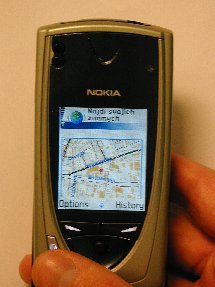
Orange Slovensko, the largest Slovakian telecommunication operator, recently launched a suite of mass-market short message service (SMS) and wireless applications protocol (WAP) location-based service (LBS) applications based on ESRI's GIS technology, and Cell ID mobile positioning. Those selected for the 2003 ASPRS Outstanding Service Award include ASPRS Sustaining Member Companies SAIC, Inc. for its sponsorship of the Estes Memorial Teaching Award and AERO-METRIC, Inc., for its initial sponsorship of the Paul R. Wolf Scholarship. Also honored were ASPRS Members Allen Watkins for his efforts to make the SAIC Estes Memorial Teaching Award a financial reality, Bernard (Barney) Schur for his vision and effort in making the Paul R. Wolf Scholarship a reality, Mary Clawson for her leadership of many ASPRS sponsored or co-sponsored conferences, and, specifically, for the outstanding 2002 XXII FIG International Congress and combined ACSM-ASPRS Conference and Technology Exhibit, and Sky Chamard for his many years of dedicated service to the ASPRS Certification Program. MapInfo Corporation extended its long-standing partnership with Statistics Canada (STC) to provide customers with the industry's first location-enhanced demographic solutions that utilize data from the most recent 2001 Canadian Census. Spatial Insights, Inc. is now a reseller for Map-In-A-Box, from Mapping Solutions. The product is an add-on to MapInfo Professional 6.0 that seamlessly integrates Microsoft's MapPoint 2002 functionality into MapInfo Professional. Cadcorp, the developer of the Cadcorp SIS - Spatial Information System - digital mapping and geographic information system (GIS) software suite, has been ranked No.1 in customer satisfaction in a GIS market survey carried out in Australia and New Zealand by Brisbane-based Corporate GIS Consultants. Kudos to distributors Integrated Spatial Systems in Sydney and PhotoMapping Services in Melbourne. eCognition elements, a stand-alone software that extends the renowned eCognition product line, will start shipping in April 2003. An easy-to-use Windows-based application, eCognition elements is designed for users with a wide range of remote sensing skills, from the novice to the expert.
� Contracts Three external suppliers won long-term contracts for rural data capture for the OS. The contracts started six months ago with Simmons Aerofilms, IGN FI and Kampsax A/S (a member of the COWI Group, Denmark). The work involves revising data that is central to forthcoming layers of OS MasterMap - Ordnance Survey's new digital map data - including improvements to the positional accuracy of features in rural areas and selected rural towns. Research Systems, Inc. (RSI), a wholly-owned subsidiary of Eastman Kodak Company, announced that Ellis GeoSpatial (Walnut Creek, California) has selected RSI's ENVI Software to use in conjunction with hyperspectral imagery to map onshore oil seeps and create detailed environmental baselines. TruePosition Inc. announced a multi-year agreement with Cingular Wireless to provide a location-based E-911 technology for Cingular's GSM networks. The same agreement also states that Cingular has contracted to upgrade its existing TruePosition location system to the TruePosition GSM location product as well. Resource GIS and Imaging Ltd. (RGI) announced that the company has been awarded a contract by Public Works and Government Services Canada for provision of 14,900 square kilometers of one metre resolution satellite imagery from the high resolution IKONOS satellite owned by Space Imaging of Thornton Colorado. To reflect the company's focus on satellite imagery and derived information RGI will be changing its name to PhotoSat Information Ltd. on April 1, 2003. Round Rock, Texas, working with the Capital Area Planning Council (CAPCO), chose Sanborn to update the city's GIS data. PPL LA announced a Letter of Intent with 4DataLink for PPL's Latin American companies. This precedent setting agreement represents the first time PPL as a corporation has chosen one vendor for all of its Latin American companies. PPL Corporation, headquartered in Allentown, Pennsylvania, controls about 11,500 megawatts of generating capacity in the United States, sells energy in key U.S. markets, and delivers electricity to customers in Pennsylvania, the United Kingdom, and Latin America. 4DataLink provides GIS solutions for electric companies.
� Products ESRI Business Information Solutions (ESRI BIS), a business unit of ESRI, announced the release of its 2003/2008 annual updates and projections of demographic data. The ESRI BIS data development team recalibrated its models to all of the data from Census 2000 including the recently released Summary File 3, sample data that were not available in 2001. GeoFields, Inc. has released a new version of its flagship software, Facility Explorer 4.0. Facility Explorer organizes and manages all pipeline-related information in a central database, and makes it available to any authorized personnel throughout the organization. This release builds upon the Facility Explorer concept of being able to access and analyze a wide variety of information in order to make sound decisions for pipeline management. Avenza Systems Inc. announced the release of MAPublisher Lt - a plug-in for Adobe Illustrator and Macromedia FreeHand. MAPublisher Lt, a subset of Avenza's flagship MAPublisher software, allows users to import maps in various GIS formats directly into Illustrator and FreeHand with all attributes intact. Cadcorp is now shipping V6 of its Spatial Information System (SIS) software. Cadcorp SIS Version 6.0, supports four OpenGIS Web Services: Web Map Service (WMS - serving raster images of maps); Web Feature Service (WFS - serving vector data in GML format); Web Terrain Service (WTS - serving raster images of 3D views); and Gazetteer Service (finding geographic locations based on attributes). Storage Area Networks announced introduced its EarthWhere 2.0 Web-based spatial data management and provisioning application. Available for full commercial implementation beginning April 1, EarthWhere 2.0 provides a solution to the problem of inefficient spatial data access. Early results from EarthWhere 2.0 Beta sites indicate the product provides as much as a 20-fold increase in productivity for spatial imagery users. DM Solutions Group Inc., a Web mapping solutions company, today announced the release of MapLab 2.0, a suite of Web-based open source tools. MapLab was developed by DM Solutions Group to simplify the process of deploying MapServer Web mapping applications. Telcordia Technologies, Inc., through its subsidiary MESA Solutions, today announced the latest release of Telcordia Network Engineer software, version 3.0. Significantly new functionality in version 3.0 addresses next generation network challenges of efficiently operating and managing networks, and delivering competitive services. � Events ESRI announced that it will sponsor the Vespucci Initiative Summer School on geographic information system (GIS) technology, which will focus on location-based services (LBS) and spatial data infrastructures. The summer school will be held at Villa Demidoff in Pratolino (Florence), Italy, from July 28 to August 8, 2003. � Hires and Appointments GenaWare announced the recent hiring of Jon Polay, Vice President, Sales, Gina Guerrieri, Sales Executive and Juli Pankow, Sales Administrator. MapInfo Corporation announced that Wayne McDougall, vice president of finance and corporate controller, will assume responsibilities as chief financial officer on an interim basis, effective immediately. He replaces Joseph Gersuk who has resigned from his position as executive vice president, treasurer, and chief financial officer to pursue other business opportunities. Gersuk will remain with the company until March 31, 2003 to assist with the transition.
ADVERTISE WITH US
CONTACT
SUBSCRIBE/UNSUBSCRIBE |