|
Letters, Points of Interest, Week in Review, Back Issues, Advertise, Contact, Subscribe/Unsubscribe
A CLOSE LOOK AT PICTOMETRY I met with Julian Rathnam, Pictometry's District Manager for the New England Region, who gave me the guided tour of Pictometry's imagery and software. He started with some background on the company. The company was founded in 1998 based on an idea that was formulated at the Rochester Institute of Technology in 1995. The idea was to be able to see the world from georeferenced angled views, like people are used to seeing it, instead of the straight down views that were available at the time. Pictometry's patent, which stems from the academic work, details what is now the company's data capture methodology (more on that later). The company is privately funded and has a mix of technology and business people on the board. Pictometry started offering products in 2000 in a low-key way. Rathnam didn't apologize for the quietness of the company, but reasoned, convincingly, that this was simply a conservative move in the face of dot-bomb years in the new millennium. Recent coverage in several newspapers and on TV, as well as the company's willingness to meet with me, make it clear that the company is ready to tell its story a bit more widely now. The Imagery
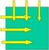
Rathnam broke the company's offerings into two key parts: the images it captures and provides, and the software tools offered to exploit that imagery. Let's start with the imagery. The company cleverly uses common terms to describe the resolution of the imagery: "community" means two-foot ground sample distance, "neighborhood" means six-inch ground sample distance. Those digital images come in two flavors: standard orthos (which can be provided by nearly anyone) and oblique images (taken at an angle, which are less widely available). The orthos are nadir images (taken "straight down" from the plane), and obliques are taken at a 40 degree angle. For those exploring oblique imagery, one important aspect is the direction from which images are taken. In other words, which sides of the buildings are users going to see? The "basic" package at the community level includes imagery from perpendicular directions, so users see two adjacent sides, as the figure at left highlights.
The choice of direction is determined by the flight plan, which is, in turn, determined by the shape of the area to be covered. Said another way, Pictometry decides the directions. The neighborhood obliques are taken from opposing directions, as the figure at right shows, again determined by the shape of the area to be covered. If the customer prefers, Pictometry will fly the "other two" directions at either level at an additional cost. The Software In and of themselves, the images don't sound that exciting, but it's the software, and what it can do with the images, that gives the company the deserved "hot" reputation it has acquired thus far. First off, the interface of the software, called Electronic Field Study (EFS), is slick. The main pane of the Windows-based product holds the image or map that's under consideration. Click on a point in the main image and a list of thumbnails of images that contain the point populates a tall, thin, right hand pane. If you have a whole set of orthos and obliques for an area, this can mean a large number of images! Pictometry also delivers images similar to the Digital Orthoquads (DOQs) provided by the USGS. Users can add any imagery into the image library as long as the data is geo-referenced.
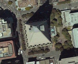
Each image produced by Pictometry, whether ortho or oblique, is geo-referenced at the pixel level. So, if you click on an oblique, like the community level one at left from San Francisco, you can get an accurate x,y location. That ability is what powers the rest of the "magic" in EFS. The magic, in reality, involves cameras, ground truthing, an inertial measurement unit (IMU), and some specialized software. Each image thumbnail is accompanied by its name (a code that distinguishes between community and neighborhood images, orthos and obliques, and provides the date of flight) and a compass rose. I quickly learned that the compass rose is very important. For orthos, which are by definition "north up," north is at the top of the rose and south at the bottom. So, as Rathnam explained, we are sitting in the south, looking north. This is more important with obliques. For them, any near-cardinal direction will be on top, making it clear which way the camera, and thus the viewer is looking. While users may rename images according to their preferences Rathnam said that once they get the hang of the coding and the compass rose, most users choose not to change them. The opening image for a county image library, for example, is typically a raster map of the area. From there a user can drill down, point-by-point, image-by-image, to find the area of interest. It's very intuitive, although it involves much pointing and clicking. (It reminded me of "hunt and peck" typing.) That said, the images are compressed and came up very quickly on the P2, 1 Ghz laptop Rathnam used. The company defines a minimum hardware requirement of a P2, 500 Mhz machine with 128 Mb RAM, but suggests 256 Mb of RAM. Images used in Arlington County, Virginia, were specially compressed from about 18 Mb to 1.5 Mb. Most images run about 3-6 Mb, once compressed. The image from which the neighborhood oblique image below was derived, weighed in at 6 Mb.
There is another way to get around the database of imagery which depends on "geocoding." Rathnam made it clear that this works only if the geocoded data is provided by the client. He showed me a demo of Arlington County, home of the Pentagon and Reagan National Airport. The county provided point geocoded addresses (that is, each address had a point linked to its street address in the database). So "geocoding" didn't mean creating an x,y from a surrogate (like interpolating from address ranges, which many of us consider "geocoding") but rather doing a database search and showing the result on the map, and, in turn, the images that contain it. It was fast and clearly would be helpful for emergency response-type applications. EFS can input vector data from a GIS. And, it's possible to take the Pictometry images out to a GIS, too. One of the video clips Rathnam showed included an analyst using EFS on one monitor and something that looked like ArcInfo on the other. Rathnam makes it clear the technologies are complementary, and that Pictometry is not in the GIS business. The company is pursuing relationships with ESRI and others (more on that later). The Magic Once the image of interest is on the screen, it's time to do work. Rathnam grabbed an ortho and measured the distance from the pitcher's mound to home plate at a baseball diamond. The actual distance is 60 feet 6 inches. Our measurement was 60 feet 5 inches. (This was zoomed out so we didn't identify the exact pixel that contained the "rubber".) Rathman assured me that if you zoom in and select the "right" pixel at each end of the line (the rubber and the plate) the measurement is even better. The tools are designed such that measurement can be made while transparently zooming between the points during the measure command. Next, we looked at an oblique and measured a light pole. The height was just about right. The program uses two different tools (and two different algorithms) to measure distance on the ground and height, which makes sense. You can also digitize an area on an ortho or oblique to get a square mile measurement, which can be changed to whatever units you need. Accuracy That brought us to a discussion of measurement accuracy vs. positional accuracy. The former is pretty good as I described in the baseball diamond example. Positional accuracy varies based on the granularity of the surface used to create the image. A coarse DEM will yield 2-5 meter accuracy, while a detailed DEM, as from LiDAR, will yield sub-meter results. Users and Uses Pictometry is taking its offering to two key areas: public safety (police, fire, emergency response and such) and assessors. There is a great deal of interest from regional planning agencies. Here in Massachusetts, despite interest from a variety of players, it was Mass Highways, a statewide planning organization that funds regional planning agencies, which had the money and stepped forward to set up a contract, for $1.86 million. That contract provides imagery and software for use by all state and local governments. Pictometry expects the data capture to be completed this spring with final delivery soon afterward. Weather interfered with the original plans to have the project completed last year. Emergency responders are quick to see the value in the system. State police immediately realized it would have helped in a situation where the first floor was the first floor on one side of the building, but the second floor on the other. That information was not available to firefighters trying save colleagues who identified themselves as being "on the first floor." In Connecticut, a helicopter coming to aid State Police officers got caught in power lines causing two deaths. While it is not certain that Pictometry's database would have prevented these tragedies, responders see the value of having more information at hand. Pictometry is also available for non-emergency situations, such as planning a sting operation. Police can see which houses or foliage can be used to hide surveillance teams. Large events, like marathons for example, can use the images to plan crowd control. One county uses the images to find safe distances for attendees at fireworks shows. Assessors in Florida are using the images to check out false claims for exemptions. The imagery went to court with the assessor after a landowner protested the denial. After one look at the printed image, the judge sided with the county. One assessor found a whole fleet of air conditioners that did not have permits. Licensing Rathman suggested that the company's prices for imagery were quite competitive, even with the software and obliques. But the imagery is licensed. That means that if an organization wants to re-up in two years, it reinvests the same amount (roughly) for updated imagery. If the organization chooses not to re-up, it can negotiate to license the existing imagery in perpetuity. My hunch is that this licensing arrangement may allow the company to offer rather aggressive pricing. The Business Side A Solution for Civilians To get the business side of the story about Pictometry I spoke with Dante Pennacchia, Sr. VP of Sales & Marketing, and Scott Sherwood, Vice President of Marketing Initiatives. Several words and phrases permeated their discussion of Pictometry: "point of contact," "civilian," "as we normally see it." These all highlight how the offering is positioned. Pictometry is meant to be used at the point of contact or need, which may be a dispatcher, a police officer, an emergency responder, or an assessor, in a call center, a police car, at an accident scene, or in the office, respectively. The "civilian" part of the equation refers to the fact that these are not specially trained GIS or geospatial professionals. Pictometry's imagery and software present the world in the same way that people see it everyday, from an oblique perspective (thus the term "as we normally see it"). This means that there is little training in interpretation and that these professionals can see the immediate use for the imagery. Perhaps that's why sales tend to move very quickly. Pictometry and GIS
I asked about the relationship between Pictometry's offering and GIS since I noticed a GIS system sitting alongside EFS in one of the videos. Sherwood makes it clear that the offering is not meant to replace GIS or existing imagery, but rather to work with it. He is the first to say that organization should not toss out their orthos, like the neighborhood one at left, which Pictometry produced, but rather add to them. Two special facets of Pictometry distinguish its obliques from traditional orthos. First, it makes "night into day." As an example, Pennacchia suggested a helicopter pilot searching for a landing site at night. Orthos will certainly show some features and open areas. They will not, however, show powerlines, or note their height. Those same powerlines are also nearly invisible in the night sky. The other is that orthos are typically taken "leaf off" so that buildings, curbs, and details can be seen. Pictometry generally flies during "leaf off" also, but can do both "leaf off" and "leaf on" in a single library. For example, by flying "leaf on" in the communities it can provide county planners with beautiful images of places to entice new business to the county, while still showing the curbs, buildings, and fire hydrants with six-inch pixel resolution in a "leaf off" environment. The company's solution provides "an added ingredient" to GIS, Pennacchia offered. Pictometry works with GIS by working with partners. The project furthest along is with ESRI. It's possible now to use an ESRI product to locate a point of interest, pass the coordinates to EFS, and bring up images that include that point. While that's a rather loose connection, down the road the plan is to develop an extension for ArcGIS that would put EFS functionality right inside the software. Pennacchia shared that Pictometry is also talking to other GIS and CAD firms about this type of solution, including Autodesk, Intergraph and vendors involved in appraising, and 911 dispatch solutions. Pennacchia went on to explain that GIS organizations that implement Pictometry find that it "expands the responsibility of the GIS people." (I immediately pictured an even more overworked GIS staff!) In fact, Pennacchia suggested that the data available to the GIS departments' constituents is more useful, and that the operators need less training. That turns into more support for the GIS department, which in turn, he suggested, makes GIS and GIS departments more important overall to their communities. One constituent of local, state and federal governments are citizens. "Lay" citizens grasp the visualizations easily and find the images easier to decipher than maps or orthophotos. This idea, making imagery accessible for both citizens and professionals, is what Pennacchia refers to as "democratizing visual intelligence." Funding and Finance I asked about how the now cash-strapped counties and states could afford both GIS and Pictometry. I suppose I was thinking funds would come from the same budgets. Pictometry's experience is that once the agencies of a state or county see the solution, money can be freed up from individual departments, such as 911, appraisers, economic development, police, fire, district attorneys and others. Pictometry's business model, in which the company owns the imagery and users license it, has some interesting ramifications. First off, there are no "per seat" sales. The imagery is licensed with the software to a site: a company, a town, a county or a state. That means, in Pennacchia's words, "everyone from the janitor to the governor can use it." It also means that Pictometry can resell, or re-license the same imagery to more than one client. What's Next? What's next for Pictometry? The company is continuing its work on integration with GIS packages and has been researching change detection functionality. From emergency response, applications will expand into natural resources management areas such as agriculture and tracking coastal erosion. Finally, expect to see more of Pictometry. The company is looking forward to exhibiting at this year's ESRI User Conference.
GEOMEND TAGGINGS PUTS LOCATION INTO HTML Metamend focuses on search engine optimization and promotion technologies, strategies and solutions. Basically, it provides a service that visits your website monthly and makes it more attractive to search engines. The geographic element is a new addition, first announced in February of this year. While this implementation is new, several search engines already provide location-based searches. The company plans to offer the tagging as an extra value-added service to new customers, but will offer it free to existing clients. Tim Mayer, vice president of FAST Web Search, a partner with mobile phone provider Vodaphone, is apprehensive about the future of Metamend. "Unless it's a product that everyone uses, I don't see it being useful," he said. "You need an independent agency or large company to push a standard." I contacted Metamend for further details about the geocoding process and the "openness" of their tags, but did not receive a reply before press time.

BOOK REVIEW: SELLING THE INVISIBLE This isn't a how-to book or a dull textbook. Is a straightforward look at the challenges of selling something that your clients can't feel, smell or taste. Furthermore, the author points out that few clients are cable of distinguishing your proposal (or final work) from that of another firm. For that reason, many of the associated parts of a firm carry more weight than the service itself. The book is truly a great wake-up call if you'd not thought about services this way before. The book is chock full of examples of making the invisible visible: Prudential Insurance's "rock" is as visible as Allstate Insurance's "good hands." With stories to highlight each point, the book is very readable. Though each "lesson" is presented in italics at the end of each little story, it looks to me as if few people have read the book, or if they have, they've not taken it to heart. Here are some of Beckwith's pearls of wisdom, ones that I see "broken" daily: "Saying many things communicates nothing." "If you think your promotional idea might seem silly or unprofessional, it is." "You cannot bore someone into buying your product." (David Ogilvy, of Ogilvy and Mather) "Tell the truth. Even if it hurts, it will help." And, my favorite story: A man had a squeaky floor. He tried everything but couldn't stop it. He finally called a carpenter. The carpenter walked around the floor, took out a hammer and nail and tapped in the nail. The bill, for $45 read: Hammering, $2. Knowing where to hammer, $43. The moral: Charge for knowing where. If you are involved in selling, promoting, defining, marketing or advertising a service organization, Selling the Invisible is worth your time. It may just put what you do in a new light for you, and your clients.

It was interesting that many of the demonstration that I've seen of late highlighted workflow issues. Not this one. After a review of GIS 101 we looked at a series of screen shots that showed how GIS was used in public works and engineering related areas, including traditional land development and surveying, as well as more esoteric ones like weed management and tree trimming. Next up was a case study on GASB 34 and how GIS helped Saco Maine meet those requirements. Saco will also be featured in a Web seminar hosted by ICMA and co-sponsored by ESRI on April 3. We took a jaunt through the now very extensive ESRI product line. The extensiveness was further highlighted when an attendee asked about a document to address all the different products and what they did. (I recall when I could count on one hand the products available in 1993. There are now probably a hundred different products.) I saw, for what I believe is the first time from ESRI, the pyramid of GIS users. I suppose that's now in the public domain and "required" presenting at every GIS seminar. What followed were a few quick demos of specific functionality: bringing in CAD data, using scanned data, georeferencing imagery, and isolating a broken water pipe. This approach may have been correct for the clearly experienced audience-50-75% already use ESRI software. Finally, we saw demonstrations of a partner product from RouteSmart, and ESRI's own ArcLogistics Route. A second partner, TeleAtlas, was unable to attend. As GIS practioners, even at the entry level, become more savvy it behooves vendors to carefully lay out what they intend to illustrate or teach at these events, to meet attendee needs, and in the end, the vendor's needs. ESRI begins a whole new seminar series on land records management this week.

One big question was addressed by a panel: Are Wi-Fi (wireless Internet from "hotspots") and cellular communications complementary or competitive? There's no definitive answer at this point. And, it's probably no surprise that Qualcomm's CEO and a Samsung representative see cellular as winning over Wi-Fi. There are early technologies that can use both types of networks. Just this week T-Mobile USA and Boingo Wireless established a relationship to share Wi-Fi hot spots and GPRS (General Packet Radio Service) cellular networks. Wi-Fi is fast but doesn't carry too far, GPRS is slow, but far more ubiquitous. I'd expect to see more of these relationships down the road. A related geographic question was also explored: How helpful is Wi-Fi if it's not ubiquitous and not shared between providers? The idea of "universal roaming" is still up in the air as more and more Wi-Fi hotspots are deployed by different companies for a charge, and by others for free. There is at least one piece of good news on the cellular front, at least for some. It seems carriers are making progress on wireless 411, wireless directory assistance. There are still issues about how and if people can be unlisted, but it's progress. Another good piece of news for LBS: data services usage by wireless customers, is growing. Data services include news and messaging options, and may be where LBS falls for some carriers. More than 30% of AT&T; Wireless subscribers to its new GSM offering are also signing on for data subscriptions. Others are using the "pay as you go" option. Sprint PCS reports an even higher sign-on rate for its PCS Vision data service. The most popular uses to date are sending pictures, and messages using Short Message Service (SMS). SMS got a boost earlier this year as U.S. carriers rolled out support for SMS between carriers. Similar interoperable support for multi-media message service (MMS) is expected soon. MapInfo announced that it has teamed with MasterCard to create the first mobile ATM Locator. Now available to TELUS Mobility PCS and Mike clients across Canada, the MapInfo-powered ATM Locator enables users to locate more than 35,000 MasterCard, Maestro, or Cirrus ATMs using their mobile phones. Users must key in their location and are charged per query. The release touts that this tool will save bank machine users since they can query only for "their" bank and avoid charges from other banks. That will be a draw, so long as the cost to find one's own bank is not more than the charge for using a competing bank's ATM. MapInfo and Sendum Wireless Corporation unveiled a family of wireless tracking devices at the show. Using MapInfo miAware, Sendum's tracking devices enable companies to track assets ranging from packages to cargo to vehicles. My thought is that it's a bit late to be entering this game, but it is a "hot" market, something MapInfo has been seeking for the last few quarters. Kivera announced a partnership with Tele Atlas to use the data company's North American map and traffic data. Rand McNally said its new Mobile Travel Tools can make directions available on next-generation cell phones using Java browsers. No deals yet with carriers. VisuAide launched its Trekker GPS-based PDA application operating on a PocketPC with WinCE, adapted for the blind and visually impaired with talking menus, talking maps, and GPS information. Data is from Navigation Technologies. Motorola introduced Viamoto, a series of applications for navigation. The applications have cute names like Goviamoto and Findviamoto, and the phones "speak" directions. Cambridge Positioning Systems Ltd., which provides enhanced-observed time difference (EOTD) location technology, said it is expanding its range of products for third-generation networks. Intrado introduced IntelliVector LBS, an outsourced, managed solution that provides carriers with low-risk entry to enhanced revenue generating services without significant capital and operational investments. It includes tools from Microsoft (MapPoint .NET) and Mobilaris. Openwave Systems Inc. announced Openwave Location Studio version 2.0, middleware to broker the secure exchange of location intelligence in operators' networks with third party applications. Openwave's software suite allows wireless network operators to provide commercial and emergency location-based services. In addition to Openwave Location Studio, Openwave's wireless location product portfolio includes Location Manager, Intelligent Network Routing, Friend Finder, and SafetyFirst. The majority of the U.S. operators have deployed SafetyFirst. Autodesk Location Services, and Openwave Systems Inc., have partnered to offer hardware and software for an LBS implementation. The Autodesk division showcased a new J2ME service creation prototype application for its LocationLogic LBS. Trimble and Infineon Technologies announced that their integrated GPS chipset and software solution will be available in an even smaller package, one less than a square centimeter, about half the size of a chip used for vehicle navigation. Based on Trimble's FirstGPS technology, the VQFN chipset solution allows high-volume manufacturers of consumer products to easily and cost-effectively add GPS location capabilities with minimal impact on device size or battery life. It's expected to be used in consumer products. (More below on Infineon in Points of Interest.) In other CTAI news, the organization's fall show has been renamed, "CTIA's Wireless I.T. & Entertainment 2003." I suppose that indicates where the organization thinks wireless is heading. Finally, Bill Gates presented the closing keynote at CTIA on Wednesday afternoon. He was expected to announce news regarding Microsoft's .NET location-based service platform, MapPoint Web Service.
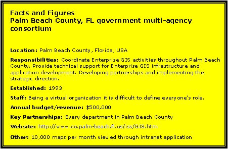
This month I want to introduce Kelly Ratchinsky, Countywide GIS Coordinator for Palm Beach County, Florida. Kelly started working for Palm Beach County in 1999 and has over 17 years of GIS experience. Originally from Canada, his background includes private sector experience providing GIS consulting services, as well as working as the GIS Coordinator during the successful implementation of Enterprise GIS in the country of Qatar. You said, "We have been integrating GIS into Palm Beach County business now for the past two years." How did that come about? Was it a push from the GIS side, or a push from the business side? The push came from the middle of these two. Once more accurate GIS data was easily accessible, the business application developers and the GIS staff within the County began going through an education process before things really started to take off. The education process consisted of doing presentations to staff on the new enterprise environment and going production with a browser based geographic navigation tool (GeoNav). The intranet Web application allowed everyone to see the vision we have been talking about for the past decade. The progression to integration has happened over several years and driven recently by the existence of the Enterprise GIS environment. It simply was not possible to integrate geography with business applications when the geography was only accessible through GIS software and stored in several different formats on many different departmental systems. Now that we have the geography stored in a single format and served up from an enterprise server, integration with business applications is possible. Tell me about some of your applications that illustrate this integration. Which agencies/cities, do you work with? Planning, Zoning and Building (PZB) and Environmental Resource Management (ERM) are involved with integration of GIS into their business processes. Both are developing business applications from the ground up and modeling the geographic data along side the business data. The applications are also being developed to support maintenance of both business and geographic data. In fact, where it makes sense, the business data is used directly to update and maintain the geographic data. For instance, GPS coordinates are already being captured during the business process, when these are entered into the database the geographic entities are automatically created and updated into the appropriate geographic layers. There still is a QA/QC component, but the data is only entered once through the business application, not the GIS application.
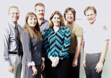
The county stores its spatial and business data in Oracle. Do you think that allows you to do things you couldn't do a more traditional GIS solution? Do you think it affects how other departments see GIS? This gives us an advantage over what the traditional GIS vendor formats can offer. We use the referential integrity capability of Oracle to help trigger updates to geography. In some cases the geography is updated automatically and in some cases it can trigger an event that will notify GIS staff that an update is required. We can create records in the geographic layers with no geometry, carrying over the related key fields, and then GIS staff create/update the record with the appropriate geometry. (Kelly's the third person from the left in the back row. -Ed.) The Oracle data model also allows us to write spatial queries in SQL or PL/SQL without going through middle tier software. We have several business applications that provide answers based on spatial relationships without going outside Oracle. Oracle Procedures are built to do intersects, buffers and unions between geographic layers. We feel like this provides us additional flexibility when designing the business application. For example, if a business application needs to know what zoning, zip code, city and impact fee zone a given parcel is in, we can perform all necessary spatial operations within Oracle. No map is needed, no map is built, no middle tier software is required to obtain the information that the business application requires. You pointed me to an application that finds what district a particular address is in and noted that the result is NOT a map, but simply the answer to the question. Is that something that non-GIS people want that we GIS people can't understand? As you know, GIS professionals come from many different fields of study. Many come with an emphasis on computers and maps. The emphasis on the map product can divert you from what the business need might be. It's just not glamorous to provide an answer, using geography, without displaying some kind of map to represent the answer. We begin by asking the question "What's more important, the answer or the map?" In many cases we find the non-GIS user would like the answer as quickly as possible. In some cases, such as with Public Safety, making the map takes valuable time away from getting the answer. And in others the map takes precedent when the answer is difficult to express without a map to depict it. It has been our experience that most GIS professionals assume the map must be created in order to answer the question and thus the question of what's most important to the business need doesn't get asked. What had to happen technically and organizationally to make this integration possible? What are your recommendations for new GIS coordinators? Palm Beach County has been working for over a decade to get to this point. Much has been accomplished in the last few years due to the foundations that had been put in place in prior years. The organizational aspects were being put in place as the technology was evolving. Not enough emphasis can be made on the importance of the organizational aspects of creating an enterprise GIS environment. Some of the milestones are: creating an organizational structure, base map standardization, establishing a GIS Information Policy endorsed by the Board of County Commissioners, establishing a technical infrastructure to support enterprise solutions, evolution of relational database architecture to allow the storage and retrieval of geographic data and evolution of GIS software providing us the tools we need to publish and integrate geography with our business data. Our recommendation to new GIS Coordinators would be to focus on building a strong foundation built on consensus. The foundation consists of establishing organizational structure, funding sources, partnerships, and standards. Long-term strategic direction requires continuous planning. It takes many people to make a system and ensure its continuance. Continuously cultivating a spirit of cooperation requires constant and consistent communication as well as developing excellent people skills. What is the role of County GIS? How will that role change in the next five years? The horizontal nature of GIS technology dictates that Countywide GIS is a virtual organization. Countywide GIS in Palm Beach County is an organization comprised of executive, managerial and technical staff across multiple organizations. Our role is to expand the sphere of GIS to encompass a broader audience and add additional dimensions to the system (time & space) through a focus on efficiency, responsiveness and quality. The role described above may not change significantly over time, however the tactical objects we work on will. Currently we are working on streamlining processes within and between county departments, integrating GIS data and technology, developing a location based enterprise addressing system and pushing some of this out to the web. In the next five years, we'll want to inter-operate better with cities and other government agencies, develop and utilize wireless technologies, extend application development services and web hosting to other public entities, and bring other public entities onto the County's wide area network to access data and applications. I understand that the county, instead of defining required GIS software for each agency, instead standardized on Oracle for data storage and let each group select its own compatible software. How is that working? Great, this allowed agencies to make their own business decision with respect to what GIS software they would use and we focused on how GIS information would be shared in an enterprise environment.
Internet Applications PBC Public Information Office - District Locator PBC Public Safety - Surge Area Mapping System (SAMS) Florida Department of Health - Child Care Centers Facility Lookup PBC ERM Coastal Resources Application Do you work for an Innovative Organization that should be profiled here? Drop me an e-mail explaining why. "I am living in Germany and I have seen those marks in Berlin, Frankfurt and Munich. Especially in Munich I have seen many of those marks. "There is even an illegal newsgroup where you can search for 'free' web-surfing." � Sunil caught an error in last week's issue: "This is with reference to the 'GIS Monitor March 13, 2003 from Professional Surveyor Magazine' edition. "Under the News Break it is announced that 'TerraQuest, a UK supplier of data management services to local government, and Infotech, a global spatial services provider, have signed a framework agreement to set up a dedicated offshore Centre of Excellence, located at Infotech's Hyderabad production facilities in India.'"In the above statement Infotech is linked to URL of 'Tata Infotech Limited,' I feel it was incorrect Link. As per my knowledge it must have a link to the site of 'Infotech enterprises Ltd.' Please confirm." The editor replies: Sunil is correct. Infotech is www.infotech-europe.com. I apologize for any confusion. � Tom Schwartzman, writing from the UK, has a geography question on this news item from last week. "NovaLIS Technologies is working with Montgomery County to implement two of its land records management solutions. The county is converting its CADD based parcels and will be using Parcel Editor as their maintenance tool. They are also in the first stage of implementing Land Development Office to automate planning, zoning, and code compliance." "� I have no idea which Montgomery County [you] are talking about as there are many of them (18 I think) in the U.S. Of course, the only reason I do care is because I grew up in a Montgomery County (PA); most people probably just glance right over it." The editor replies: That's my fault. The title of the release includes reference to Montgomery County, Virginia. My apologies.
POINTS OF INTEREST � GPS without GPS. Siemens is has introduced Parcel Watch Service, a mobile data system that uses GSM and GPRS cellular networks to track merchandise shipments and individual goods via the Web. It seems logical for tracking applications to try to cut costs by using network tools for location rather than typically more expensive GPS. Moreover, since the signals don't require line of sight and work indoors, it's a logical step. Radio transmitters, and optional other sensors for light or temperature, report the location (based on cell-id) to a server and the path is posted to the Web. If the sensors monitor a problem, an SMS message gets sent out. Like Digital Angel or Wherify, the sensors can be attached to people. Siemens is conducting field trials in Germany with Vodafone and expects to make the product commercially available in April. In the U.S., the company has approached T-Mobile and AT&T; Wireless. Costs are expected to run US$4,000 per month for a complete system, which includes 300 radio modules for tracking moving objects, or 1,000 modules for tagging stationary objects, like ATMs. � Standards and the law. There's been a lingering lawsuit between Rambus v. Infineon. It's sort of complicated, so hang on. Rambus, of California, makes electronic ports that allow memory chips to communicate; Infineon Technologies ADS of Germany makes semi-conductors. Rambus, in the early 1990s, was a member of the Joint Electron Devices Engineering Council (JEDEC), which promotes technology standards. During that time, JEDEC developed and adopted a standard for synchronous dynamic random access memory (SDRAM). Apparently, Rambus, for some time tried to claim rights to the intellectual property in the standard. Once the standard passed, Rambus asked for payment on its patent and sued some companies who implemented the standard (including Samsung, Hitachi, Hyundai, and Micron Technology). It seems that Rambus didn't disclose the patent until after it left JEDEC. Infineon, which produces SDRAM, was one of the first to accuse Rambus of fraud. Rambus sued over patent infringement. There was a counter-suit, and the trial court awarded Infineon more than $7 million. The court of Appeals overturned that decision in January, suggesting that the court reconsider and nullified the payment. That would leave Rambus to sue Infineon and others. The challenge now is that it'll be hard to re-open the case for a second hearing. To encourage just that, Boston law firm Lucash, Gesmer & Updegrove LLP submitted a friend of the court brief this week on behalf of six standards organizations, including the Open GIS Consortium. (That firm represents OGC, a client of mine.) The brief, the firm hopes, will educate the U.S. District Court of Appeals on the influence the case could have on the standard setting process. � LBS delivered cabs in London. Zingo uses LBS to match those calling for cabs with the closest car. The cabs already use GPS and several carries in the UK have locational information, so it was simply a matter of marrying the two. The caller calls a nationwide number, gets located, and the service connects the caller and driver to discuss the exact pickup point. Zingo makes money from taxi driver fees of �15 per week and passenger fees of �1.60 added to every fare. For now Vodafone, T-Mobile and O2 are in, with 3 and Orange in negotiations. � Tele Atlas increased revenues 10% over last year. Growth is fueled by the in-car navigation segment. North American revenues were 5% lower due to the decline in third party sales and lower income from patents. Location Based Services, revenues came from contracts with Mapinfo (for Vodafone), Hutchison 3G, ViaMichelin, and Wanadoo. � New Scientist reports that the Pentagon would not be starting a GPS "blackout" should the U.S. enter a war with Iraq. One official, however, did not rule out a localized blackout, something that might give the U.S. quite an advantage. If such a blackout ever did happen, the article continues, it'd be a good argument for Galileo, Europe's proposed satellite constellation. � TenLinks reports that CADENCE magazine is cutting its print subscriptions to 50,000 by further limiting those who can receive free subscriptions. CMP, which publishes the magazine, is offering non-qualified readers the option of an electronic, on-line or fee-based printed publication. � How are things in London? Good news a few weeks after the "congestion charge" was imposed within a ring of the UK's biggest city. According to Australia's The Age, road usage in the 21 square-kilometer zone was down 25 per cent on the first day and traffic speeds doubled. That was during spring vacation, but once students were back at school the decrease was still 18%. There have been glitches: an antique car held in a museum was fined for travel in the city, for example. Still, the system seems to be working, encouraging officials to contemplate a nationwide scheme. That would not go into effect before 2010. � In an article in the San Mateo County Times, titled Cities Court Development via Internet, the author highlights the pros and cons of city websites that aimed at drawing development. Some of the websites he visited fail to load, others no longer provide promised information. � What are "geo-location services"? They are services based on knowing where you are. Is this term better than "location-based services"? I like it better; the "geo" prefix makes it clear you are on Earth, and I believe, highlights that something else (say GPS) is doing the locating, i.e., that the locating is automated, rather than manual. An article on CNET uses this term and hints at 411 (directory assistance) that includes location information. � Quote of the Week: "If Polly had been wearing a Wherify GPS locator, she'd be alive today." Marc Klaas, father of Polly who was abducted and killed, made the comment after Elizabeth Smart's safe return home. He was quoted in the Chicago Sun-Times.
� Announcements Trimble and the ESRI Conservation Program have entered an alliance that will put global positioning systems (GPS) into the hands of people working to conserve the Earth's natural resources. New York City's advanced-technology mapping program that provided critical information to responders during 9/11, the West Nile virus outbreak and the anthrax threat has made the shortlist for the Innovations in American Government Award from The Institute for Government Innovation at Harvard University's John F. Kennedy School of Government. British Rural Affairs Minister Alun Michael MP congratulated Ordnance Survey on the national completion of its award-winning Explorer map series, which replaces maps in the old Pathfinder series. Explorer maps are specially designed for walkers, off-road cyclists, horse riders, and all involved in outdoor activities. Ingegneria Dei Sistemi S.p.a. (IDS) and Intergraph Mapping and Geospatial Solutions have reached an acquisition agreement. Intergraph is selling the following products and technologies to IDS, but will continue to distribute them: - Aeronautical Mapping System (AMS) - Provides tools for creating and editing aeronautical charts in an interactive graphics environment. At the recent American Road and Transportation Builders Association Transportation Development Foundation's third annual "Globe Awards" ceremony, the Arkansas State Highway and Transportation Department was honored for environmental excellence in the statewide preservation of historic bridges through the implementation of the Historic Bridge Management System (HBMS). The HBMS uses Intergraph's GeoMedia solutions to effectively manage historic bridge inventory and enhance mitigation during the historic bridge replacement process by providing an easily accessible, centralized data management system via an intranet. LocatioNet, a middleware platform provider for wireless location-based services, and Geographic Data Technology, Inc. and TrafficCast a traffic information company and digital traffic data provider, announced they are partnering to provide traffic information for LBS, fleet management, and telematics applications in North America. The integrated map and traffic information will help drivers make better routing decisions and enhance the effectiveness of dispatch services. Bentley announced that Lieutenant General Robert B. Flowers, Commander and Chief of Engineers of the U.S. Army Corps of Engineers, will deliver a keynote address at the 2003 Bentley International User Conference. � Contracts MacDonald, Dettwiler and Associates Ltd. announced that the company's Geographic Information Products group has been awarded a contract funded by Hidalgo County Drainage District No. 1 through S&B; Infrastructure, Ltd. of Houston, Texas to produce three-dimensional land information of a 900 square mile area on the U.S. border with Mexico. DigitalGlobe announced that its QuickBird satellite imagery is being used by Canada's CLC-Camint Inc. to identify individual tree crowns in forest areas. Gaz de France, a French gas utility company, is expanding its Commercial Information System (SIC) with GIS software from ESRI France. Intergraph Mapping and Geospatial Solutions announced that Florida's Turnpike Enterprise, a division of the Florida Department of Transportation, is utilizing GeoMedia WebMap Professional as the Web-based GIS component for its Turnpike Enterprise Asset Management System (TEAMS). National multi-discipline consulting firm PBS&J; partnered with Intergraph to design, develop, and implement TEAMS. Space Imaging announced that the U.S. State Department has selected its Geobook GIS product for use by the Department's Future of Iraq project. PlanGraphics, Inc. has kicked off a GIS strategic planning project for the City of Santa Ana, Calif., Public Works Agency. GeoMicro, Inc. was awarded a multi-year contract to provide North American Mapping, GeoCoding, and Routing applications by TELUS Geomatics, a division of TELUS Communications Inc. � Products Space Imaging has released its new IKONOS Standard Ortho product line derived from its IKONOS satellite. Standard Ortho is a cost-effective mapping product that can be produced and delivered quickly. Designed for GIS professionals performing basic mapping projects or image classification and analysis, Standard Ortho is ortho-corrected with a horizontal accuracy of 50 meters (CE90) and obtains a 1:100,000 NMAS. As with all IKONOS imagery products, it is available in 1-meter, 4-meter or 1- and 4-meter bundles, with options of black-and-white, color or multispectral. Prices start at $22 per square kilometer. Safe Software Inc. released an enhanced version of its Feature Manipulation Engine (FME) Geographic Data Files (GDF) reader to support TeleAtlas MultiNet 3.2 GDF (ASCII) sequential datasets. UCLID Software released a new extension for ESRI ArcGIS. Swipe it! provides fast data entry of attributes, especially when the source document is a scanned image. A trial version is available. MapInfo announced an update to its demographic data for its core Canadian products, making them the first demographic analysis offerings on the market to incorporate all available 2001 Census data from Statistics Canada. Among other things, MapInfo estimates 4% growth for the country. LeadDog Consulting announced the release of Caracas, Venezuela street-level routing. � Events Digital India 2003 will be held July 10-12 2003, in Hyderabad, India. Laser-Scan announced its annual User and Partner Conference for 17 - 18 July 2003, Cambridge, UK. I will open the conference with a keynote addressing the nature of interoperability and its role in today's geospatial solutions. The Western Governors' Association (WGA), serving the Governors of the 18 western states and 3 US-Flag Pacific Islands, will host its second Western Cadastral Data and Policy Forum May 6-7, 2003, at the Wyndham Hotel in Salt Lake City, Utah. The King Faisal Specialist Hospital and Research Centre will host a symposium called "Spatial and Temporal Clustering of Diseases and Risk Assessment in Public Health" on 9 - 10 December 2003, in Riyadh, Kingdom of Saudi Arabia. Laser-Scan, in partnership with Ordnance Survey, is hosting a free seminar, specifically for the telecommunications industry. The event will be held Tuesday 29th April 2003 at the Ordnance Survey Business Centre, Southampton, UK. Laser-Scan's partner, SciSys, will host a free half-day seminar for UK Government to find out about the benefits of GIS on Wednesday April 30th at the SciSys Head Office, Chippenham, Wiltshire, UK. Delegates will learn: � How GIS can help in achieving 2005 e-government targets � Education � Hires and New Offices Azteca Systems, Inc. announced that Darrin Farmer joins the company as the Regional Representative for the Western Region. Mr. Farmer joins Azteca Systems from Digital Architects, Irving Texas where he served as the technology consulting firm's Professional Services Director. He will be opening Azteca System's Western Regional Office near Los Angeles California, serving the states of California, Nevada, Oregon, Washington, Alaska and Hawaii.
ADVERTISE WITH US
CONTACT
SUBSCRIBE/UNSUBSCRIBE |