Letters, Correction, Points of Interest, Week in Review, Back Issues, Advertise, Contact, Subscribe/Unsubscribe If, for some reason you cannot read this document, visit: http://www.gismonitor.com/news/newsletter/archive/041003.php
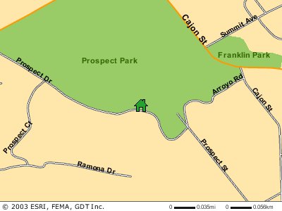
BEWARE THE MAPPING SERVICES! The first service I ran into is from First American Title Insurance Company. When commercial property changes hands there's a need for the title insurer (First American is a title insurer) to check the title for issues. This is in some ways parallel to getting a physical before you are approved for health insurance. Typically, a surveyor examines relevant documents and visits the site to prepare a brand new survey, which follows ALTA/ACSM Standards for Land Title Surveys. These standards are very detailed indeed. First American's Express Map service offers to bypass the ALTA/ACSM survey, which may save the purchaser time and money. How does Express Map get the job done? It employs "land survey underwriter specialists" and depends on aerial imagery and other documents to "clear the title." First American notes on its website that it's providing a unique service to its clients that makes getting title insurance easier. For example, the buyer need not find and hire a surveyor. Basically, First American Title Insurance Company is saying that their process, which may not include a site visit, is "good enough" for them to provide title insurance, in many cases. While the FAQ does note that sometimes a site visit is required, the suggestion is that many times it is not. Curt Sumner, LS, the executive director of the American Congress on Surveying and Mapping (ACSM) listed that organization's concerns about Express Map in a detailed letter to First American sent in January of this year. A response from the company will be posted on the ACSM website when it is received. To date, there is no response. The other service, ESRI's ArcWeb Flood Map Report, came online last week. The idea is to provide a simple, cost effective way to locate a property with respect to flood risks. It's one of two end-user oriented services ESRI now offers. The other is a business application. Typically, practitioners use official FEMA Flood Insurance Rate Maps (FIRMs) to locate a property inside or outside certain flood risk zones. These maps are legal documents. They have to be legal documents because there is a federal law that says that if you borrow money from a federally backed lending institution to buy property, and the structure on the property is in a Special Flood Hazard Area (1% annual chance floodplain, less accurately known as the 100-year floodplain), you must carry flood insurance. That law has started a whole industry aimed at answering that question of "Is the property in or out?" Until recently, FIRMs were paper documents. A digital form called Q3 is a subset of some of the features of some of the coverage of FIRMs. According to the FEMA website, "the digital Q3 Flood Data product was not designed to make strict in/out flood risk determinations" and is not a legal document. ESRI took the flood zone boundaries, in particular, 1% (100 year) and 0.2% (500 year) annual chance floodplain boundaries and overlaid them with GDT Dynamap 2000 data for geocoding. Since the base maps for the flood zone boundaries are quite varied, some significant reshaping must have been done to "fit the maps" together.
So, how do you make your flood map? You key in your address and it's geocoded against the GDT data. You review it, and if the location is correct, provide credit card information to pay the small fee. Then you get your map as an HTML document including a map like the sample from the ESRI website at left, a discussion of where the property falls, and some disclaimers. Since Q3's are not legal documents, (indicating that ESRI's realignment of them must be even further away) their value is only as a guideline. ESRI makes this quite clear: "ArcWeb flood map reports are provided for general informational purposes only." There is also an entire page of disclaimers. While both First American and ESRI can be applauded for pushing geospatial technologies as services, concerns still remain as to how they may be used or abused. Our job as knowledgeable geospatial practitioners is to help casual users understand what such services do and do not provide, and steer them toward the right tool or service for their needs.

AAG COUNCIL TAKES A STAND The resolution reads in part: "Whereas a substantial body of geographic research indicates that a pre-emptive attack by the United States on Iraq without the backing of the international community could undermine global stability, heighten tensions in Southwest Asia and the Middle East, precipitate a humanitarian and environmental crisis in Iraq, and undermine U.S. efforts to combat international terrorism." The Council passed the resolution with 11 voting in favor, 3 against, 2 abstentions, and 2 who did not vote. According to those I consulted, the AAG has passed similar resolutions, most notably regarding the Viet-Nam war in the 1960s. Furthermore, there is more than a political motive to such documents. The current resolution indicates that a substantial body of research supports the position taken by the Council. The AAG has put together a bibliography of relevant literature, which is available by request. Due to the timing of the organization's annual meeting and the energetic push to make a statement, the organization may have missed a key opportunity to show the relevance of geography to world events. In particular, detailing the research in question would give those who are interested, but who are not academic geographers, a chance to explore what the discipline brings to the table. Said another way, by producing the resolution as it stands, the organization served only itself. By providing reference to its body of work, it may have also served to support its mission of advancing "professional studies in geography and encourag[ing] the application of geographic research in education, government, and business." Interestingly, when I researched this story several weeks ago, the AAG website had been hacked.

"Your April issue of GIS monitor is right on target. I am not sure if you know of the URISA 3C Task Force, created to voice the views and issues from associations and groups interested in and affected by the initiatives such as the National Map, GeoSpatial One Stop, etc. "The URISA TF is organizing a meeting in D.C., 'Give & Take: National Programs ... Local Implementation. A URISA Summit to Promote National Data Partnerships & Collaboration'" � Lucia Barbato, Senior Research Associate at Texas Tech University, added further insight into who's making war maps. "In the Advanced GIS course at Texas Tech University, Dr. Kevin Mulligan (my husband) is having students develop maps of Iraq using ArcGIS 8.x, and later teaching them to create ArcIMS sites. "In the meantime, he has created an ArcIMS Interactive Map of prewar Iraq. I think the cartography and data are beautiful. We are sharing this website with our fellow geographers, and we would be happy to share it with your readers. "There is a webpage describing the map layer information, a link to a DigitalGlobe satellite image of Baghdad, and link to the ArcIMS site. � Don Cooke of GDT noted that I failed to mention something very important about the image purported to be the last one taken by Space Shuttle Columbia: "I'm surprised that you didn't mention that this isn't a photo at all; it is a fabrication�" The editor responds: Cooke is quite correct; all of the images on the John Walker's Earth and Moon Viewer are "fabricated." The website notes, "Images can be generated based on a full-colour image of the Earth by day and night, a topographical map of the Earth, up-to-date weather satellite imagery, or a composite image of cloud cover superimposed on a map of the Earth, or a colour composite which shows clouds, land and sea temperatures, and ice." I apologize for the oversight; that's a rather important part of the story. � Tony Flynn, Chief Marketing Officer at Bentley Systems wrote to address some issues I raised regarding the company's plans with ESRI: "In your GIS Monitor issue of March 6, you suggested that we clarify the interoperability vision shared by Bentley and ESRI. Given that Bentley's 'home base' is AEC, we'll take a shot at explaining the new value to our users. "All AEC projects and operations take place in some geographic setting. To successfully perform many of their tasks, AEC professionals need access to data relating to the underlying geography, such as land use, water bodies, swampland, political boundaries, and elevation. When AEC/GIS systems are not integrated, as is the case in most organizations today, these workers, in order to make informed decisions, must manually transfer information back-and-forth with paper copies, sneakernet, and guesswork -- or use lowest-common-denominator file transfer methods. Workflows are interrupted, errors are induced, and productivity and quality suffer. "Organizations that experience this very real pain include departments of transportation, municipalities and other government agencies, utility companies, communication providers, and consulting engineers. For example, engineers doing design or maintenance on a municipal asset must check GIS-based environmental data provided by planners. "Bentley and ESRI, as announced earlier this month, are bringing important and practical capabilities to these AEC organizations in three ways: "1. Data exchange: Bentley and ESRI are working closely together to allow Bentley users to read native ESRI file data and vice versa, automatically from within their respective applications. "2. Managed environment: most AEC projects and operations involve teams and require that data be well-managed among team members. Bentley provides key capabilities for users to create and maintain a managed environment for their information, including: change management, workflow and document management, synchronization, querying, and security of information. With this interoperability, GIS data from ESRI can be extracted and used within this managed environment. So our interoperability goes beyond simple data exchange -- the AEC system is now working in synchronization with the GIS system. The managed environment also allows for the reverse: GIS users can use current AEC data supplied by the synchronization mechanisms. "3. Spatially enabled managed environment: GIS data provides critical context and referencing for AEC projects and operations. In our new spatially enabled managed environment, AEC users get a 'helicopter' that allows them to spatially navigate the entire AEC dataset and relevant GIS dataset within one context. Users can then 'drop down' and get the details they need to make better decisions. "We believe that the combination of the three capabilities amount to a breakthrough for AEC users and a practical solution that many organizations have been seeking for years. Yes, as you noted in your article, there are other AEC/GIS data exchange options available today. Standards-based exchange, 'mocking' of AEC data in a GIS system, and integrating all GIS/AEC data into a single database are frequently mentioned options. "We feel these options fall far short of our interoperable solution. Standards alone do allow for data exchange but do not provide the unbroken workflow and spatial navigation of our solution. 'Mocking' of AEC data in a GIS system does not provide the fidelity needed for AEC work nor allow for practical AEC changes. And integrating all GIS/AEC data into a single database has proven impossible due the differing requirements between AEC and GIS in terms of transaction models, workflows, levels of detail, etc. "Significant benefits accrue from our spatially enabled managed environment. First, productivity increases because users have transparent access to AEC and GIS data within a single environment, and work on the latest and right version of data -- whether AEC or GIS. Second, an online GIS context for AEC users leads to better decision making, increased quality, and lower cost. Last, both sets of users can continue to use the tools that make them most productive -- GIS-oriented professionals continue with ESRI and AEC professionals continue with Bentley."

CORRECTION
POINTS OF INTEREST � The Inquirer reports that Thuraya's chairman, Mohammad Omran, said "that users' position data cannot be compromised." Thuraya phones have been banned in Iraq by both sides since there are fears that locations of users can be tracked. The president of Boeing Satellite Systems, which supplies technology to Thuraya explained that the GPS information transmitted via a Thuraya phone is secured and only available to Thuraya. � According to the Sunday Times (Australia) Iraqi authorities are asking Iraqis to put down Thuraya satellite phones to help weed out opponents who are still using the GPS-enabled handsets. The Pentagon moved from a temporary, somewhat limited ban on the phones for journalists and soldiers to a complete, long-term ban. Thuraya officials explain that to be tracked the user must "turn on" the GPS capability, but the military on both sides appears not to want to take chances. � The Syracuse Post-Standard has some input from Mark Monmonier (How to Lie with Maps) on the state of war maps. His biggest concern: showing the unknown. Also interviewed: the GIS Monitor editor.
Other Points of Interest � GIS Caf�'s VirtualGISCaf� on-line Expo scheduled for April 15 has been cancelled. The drawing for prizes will still occur and registrants will be notified of a new date. The April date had been rescheduled from a February date. � Autodesk is using Endeavor Technologies' Magi AppExpress to provide online trials of its AutoCAD 2000. The product is streamed via the Internet and provides full access. � Peter Batty, once of Smallworld, is a founder of Ten Sails, a company focusing on business development of early and growth-stage high-tech companies. In a GEOWorld article he writes about LBS and related technologies, in particular local positioning systems (LPS). These are systems that track location indoors, where GPS is not reliable. Among other things, he points out the benefits of accurate tracking of people and assets in hospitals or for marketing in malls. � I have to apologize for not reporting this sad news sooner. The District's Lynne Thigpen, who played GIS guru Ella Farmer, passed away March 12. Her other geography-related credits included playing the Chief on the PBS show Where in the World is Carmen Sandiego? Her previous work was on Broadway and won her a Tony award. Thigpen was 54. � The Government Accounting Office reports that not a single one of the Departments of Energy, Commerce, and Health and Human Services, or the Environmental Protection Agency has fulfilled their obligations to list critical infrastructure for their departments. Several departments deny the claim, according to Wired. The law requiring the reporting was passed in 1998. The Government Accounting Office (GAO) found that even after 9/11 the work was simply not done. The GAO also reports that private holders of critical infrastructure are not sharing their information with the government. The information is shared with Information Sharing and Analysis Centers, but those groups are reticent to share with the government since if they do, the data becomes available to the public via the Freedom of Information Act. � In the same vein, John Palatiello of MAPPS pointed out an article from The Hill highlighting that while congressmen asked that more money be set aside for homeland security, two thirds of monies from last year aimed at first responders have not been touched. � The New York Times reports that Isabel Mendes, a young Brazilian photographer is taking pictures of every fa�ade in Paris. She works for Wanadoo Maps, a kind of Yellow Pages featuring images of every listed address in major French and Spanish cities. The company has a team made up of 55 photographers who create and update the archive. Those buying real estate, billboard advertisers, and private citizens have found the service appealing. Casual users like to examine the outside of a restaurant for dinner or to send a link to a friend of "their" neighborhood when traveling. The images are updated annually. Would this fly in the U.S.? Do we already have it? � Last weekend yet another part of the huge maze called "The Big Dig" was opened in Boston, taking more than one highway exit "off-line." The Boston Globe ran an article reporting that online maps were not up-to-date. The author pointed out that YahooMaps, Expedia, and MapQuest were giving bad directions. The reporter did, however, do his homework and contacted Geographic Data Technology (GDT), the data provider for many of the online mapping sites, to ask when the company would have the Big Dig map updated. GDT representatives explained its policy of capturing changes within 90 days of project completion. The Big Dig still has at least another year before completion. The Globe author does note that local websites, in particular those hosted by Ritz-Carlton, Boston Common and the Fleet Center (home of our Celtics and Bruins) have updated mapping information. Those two websites have text-based directions and static maps. (Interestingly, the map on the Ritz page is credited to Vicinity and GDT!) � GPS-based art. Two artists in LA have put together an exhibition that requires using a GPS and a Tablet PC to discover hotpots of art around the city. The Christian Science Monitor explains that at each hotspot visitors hear about the history of area they're visiting. The project is called "34 North, 118 West." � I read the rumors but did want to report until I had confirmation: Bill Patterson did indeed resign as president and CEO of LizardTech earlier in April. Patterson explained to the Seattle Post-Intelligencer that the decision was mutual. He was replaced by Scot Land, a managing partner at Bellevue-based Encompass Ventures. � Analysts expect there to be some 10,000 for-pay wireless hotspots in the U.S. by the end of the year. That means someone must think they are going to make money on all these investments. Wired admits that hard numbers are tough to get hold of since businesses like Starbucks do not release such figures. Still, analysts suspect, "the numbers are disproportionately low compared with the number of available hot spots." � Why E-911 fails. The Washington Post reports on the continuing problem of E-911 calls not getting to the right response team. The report cites these problems: call don't get picked up (Consumer Reports found that roughly 15% of all calls fail), they get picked up by the "wrong" cell tower, 911 call takers do not have access to automatic addresses or call-back numbers. The article shares this advice when using a cell phone for an emergency call: "Provide the cell phone number and location to the 911 operator in case the signal is lost." And, if you dial 911 by mistake, stay on the line and tell the operator that's what happened, so they will not try to find you. � A few weeks back I reported on a lawsuit asking the court to reconsider a ruling that allowed Rambus to receive patent payments from Infineon on technology included in a specification the company worked on as part of the JDEEC Solid State Technology Association. The court upheld the previous decision basically saying that it was "ok" that the company could hold the patent on material in a standard. The request brought a "friend of the court" briefing from several standards organizations suggesting the ruling was in error, but clearly it did not help. � GPS' downside. While we all seem to love GPS receivers, there are some down sides. One involves once hidden historic "cave paintings" and other artifacts becoming more accessible and thus susceptible to vandalism. The Bureau of Land Management calls it "digital vandalism." Some scientists and interested amateurs are documenting digital photos of the art but hold locations close to the vest to prevent destruction. � GPS' upside. On the other hand, I saw a recent announcement for an Earth Day event specifically looking for geocachers to clean "off-the-beaten path" areas of a local wooded park. As the invitation put it, "geocachers won't get lost." Geocachers have the informal slogan: "Cache in, trash out." � Researchers at the University of Birmingham have put together their own child-tracking bracelet, similar to Digital Angel or Wherify. Ready for the name? Geobangle. � ESRI personnel were featured on a Southern California Public Broadcasting System TV show on April 1. The discussion starts with mapping and the war, but the bulk of it focuses on the non-military uses of GIS. Audio and transcripts are available. � Quote of the Week: Beryle Sessions who recently retired as the director of equalization from Brookings County, South Dakota, describes the most exciting development during her 15-year tenure: "I think one of the most exciting things that we've developed since I've been the director here is our GIS."
� Announcements
Alissa Bails, right, GIS division manager of R.A. Smith & Associates, Inc. has been elected president-elect of the Wisconsin Land Information Association (WLIA). The Open GIS Consortium, Inc. (OGC) announced the public release of the OpenGIS Reference Model (ORM). The ORM documents a framework of interoperability for geospatial processing ranging from tightly coupled, real time systems on a single CPU to the "Spatial Web" -- the open environment that enables barrier-free communication of geographic information among users of the World Wide Web. Telemorphic has launched a new public access Internet GIS and Satellite Image Visualization System for Baghdad and Iraq. Content on these sites currently includes vector and imagery datasets from NIMA, NASA, and USGS (VMap0, DOI-10, Landsat, MODIS, GTOPO30). Also includes georeferenced versions of the recently released NIMA Special Reference Graphics for Baghdad (fairly detailed 1:40,000 scale source map) and the entire country of Iraq. The Open GIS Consortium, Inc. (OGC) announced that BAE SYSTEMS has renewed its Strategic Membership in OGC, the highest level of membership in OGC. YEOMAN Mobile Navigation showed the first consumer service application of Ordnance Survey's OS MasterMap Integrated Transport Network (ITN) Layer in a version of its TRAVELM8 mobile navigation product. AtRoad Inc. got a new patent recently, bringing its total LBS-related patents to eight. This one describes a "method for distributing location-relevant information using a network." If I understand correctly, the patent is for using location to determine which data from a database is delivered. Should that be patented? The Open GIS Consortium (Europe) Limited (OGCE) announced the creation of the European Virtual Resource Pool (EVPool), and the availability of an Invitation to Qualify (ITQ). Participants in EVPool will undertake critical work to increase understanding of the benefits of OpenGIS specifications in European business and government pre-procurement settings. Intergraph Mapping and Geospatial Solutions announced that a software grant, valued at more than $3.4 million (U.S.), has been presented to long-time technology partner, California State Polytechnic University, Pomona (Cal Poly Pomona), for use in its geospatial engineering laboratory and program, medical research, GIS Center and GIS certificate and masters programs. EarthData has purchased ISTAR America. JP Morgan raised its investment ratings on MapInfo Corp. causing the stock to jump up 35 cents, or 8.8 percent on Monday. Laser-Scan, in conjunction with its partner GDC, is running a program to help local authorities prepare their data for efficient and effective use throughout their organizations, a necessary step on the road to achieving e-government targets by 2005. It's a data "cleaning" offer. Map maker Rand McNally & Co. has emerged from federal bankruptcy protection this week. The United States Forest Service (USFS) has recently given blanket technical approval for its employees to purchase Feature Analyst nationwide to aid in its remote sensing and GIS-related activities. Feature Analyst, built as an extension for ArcView 3.2 and ArcGIS software, provides users with a powerful and easy-to-use new tool for converting images into maps. A bill that would have included photogrammetry, geographic information systems, and land information systems within the practice of land surveying in the State of Illinois has been amended through the efforts of MAPPS.Senate Bill 698 passed the Senate unanimously on Thursday, April 3 with the MAPPS language added in Amendment 3. The amendment exempts photogrammetric services and removes references to geographic information systems and land information systems within the practice of land surveying. Basically, the amendment prevents photogrammetric and GIS work from being restricted to licensed surveyors. Further, the original bill failed to include a "grandfather" clause that would have provided current practitioners from avoiding licensing. ESRI announces that SICAD Utilities has begun full integration of ESRI's ArcGIS technology into the SICAD UT product offerings. The two companies' development efforts will be used not only to integrate the technologies of their current product offerings but also to create a next-generation GIS utility standard based on ESRI's technology. No date for expected release was announced. NovaLIS Technologies was named ESRI Canada Business Partner of the Year for 2002. NovaLIS received the award from ESRI Inc., at the ESRI Business Partner Conference in Palm Springs, California, in March.
� Contracts PlanGraphics, Inc. has been awarded a contract with Chengdu Municipal Waterworks Company in China's Sichuan Province. PlanGraphics will deliver project management, design and implementation services to implement a geographic information system (GIS) to manage Chengdu's water distribution system. The contract is worth $232,000. geoVue, which has used elements of Geographic Data Technologies' (GDT) map intelligence since early 1999, will be fully operational on GDT as of the first quarter of 2003, making GDT the sole provider of U.S. and Canadian geographic data for geoVue customers. � Products ESRI Canada announced that ArcGIS 8.3 is now available in Canada. Lizardtech Software announced that Autodesk has incorporated recently released lossless MrSID technology into Autodesk Inc.'s latest version of some of its software products. Autodesk supports lossless MrSID in its Autodesk Map 2004, Autodesk Map Series 2004, Autodesk Civil Design 2004, Autodesk Land Desktop 2004, Autodesk Survey 2004, Autodesk Raster Design 2004 and Autodesk MapGuide 6.3 products.
Sharp announced plans to launch location-based services for its Zaurus SL-series Linux PDAs in Japan, later this month. Once a map is dowloaded, and GPS plugged in, users locations will appear on the map. Future services are expected to include restaurant type indexes. I'm not sure how exactly this is a service, since in the U.S. that type of functionality is possible without a "service." Thales' Magellan 750 Plus series products are now available. Movable between vehicles, the GPS-based in-car navigation technology is from the same folks who produce Hertz NeverLost. Taylor Technologies announced version 3.1 of Rapid Integration Toolkit (RIT) software for Autodesk MapGuide Web GIS sites. RIT is an advanced software solution that greatly enhances MapGuide Web sites by removing the need for web programming or hard coding. In addition, RIT is now available on the GSA contract through Taylor Technologies' government solutions partner DLT. Mapopolis has introduced Mapopolis ClearRoute, for public trial. ClearRoute provides traffic-optimized routing - it automatically avoids traffic slow-downs and accidents. The public trial covers ten cities: Atlanta, Baltimore, Chicago, Houston, Cleveland, Cincinnati, Minneapolis/St. Paul, Seattle, Los Angeles, and San Francisco.

� Events The Board of Directors for the 16th Annual GIS in the Rockies Conference issues its call for papers. The conference theme is "Geospatial Integration Today for Tomorrow." Deadline for submission of abstracts is June 1, 2003. The first annual MapServer User Meeting will take place June 6-7, 2003, at the University of Minnesota in Minneapolis. The 2-day user conference will provide an opportunity for users to share their experiences, learn from leaders in MapServer development, and take part in defining the future of MapServer. � Hires and New Offices
ADVERTISE WITH US
CONTACT
SUBSCRIBE/UNSUBSCRIBE |