Letters, Points of Interest, Business Notes, Week in Review, Back Issues, Advertise, Contact, Subscribe/Unsubscribe
AUTODESK LAUNCHES MAP SERIES Don't be confused: OnSite 6 is not the same OnSite that Autodesk introduced a few years ago to address "point of work" solutions. OnSite View, a Windows CE product, is a mobile design review application that works in concert with OnSite Enterpise, the backend solution for corporate servers. OnSite 6 is a GIS product built on MapGuide Author technology. Despite its name, the product is not designed for "point of work" but rather for the desktop. It's a sort-of mix of MapGuide Viewer, MapGuide Author, OnSite View and Autodesk World. And, it has the best of both worlds in the sense that it can read local data (DWG, DXF, shape, Oracle Spatial) and Web published data from a MapGuide server. It's possible to use OnSite to develop maps for publishing via MapGuide, a sort of alternative to MapGuide Author. OnSite includes the redlining familiar from the "old" OnSite (circles, squares, text), but is not a data creation tool. Autodesk is encouraging existing Map users to upgrade their subscriptions to the new Series. Depending on whether you have AutoCAD or a version of Map, the upgrades run from $995 to $1795 - and include an upgrade to the subscription, as well. The real question for potential adopters is how good is the technology and will it fill a gap or replace an existing desktop seat of another vendor? The quick demo I saw shows some definite strengths. The screen layout and tools are just like MapGuide Author: data sources are created, symbology is determined and the information is stored in an .mwf file. You can create thematic maps via a wizard. In fact, most tasks are wizard driven. The wizards are helpful, but some seem quite long, involving five or six steps. OnSite is smart enough to read in spatial reference system data should it be stored with the data source. Data sources supported include SDF (MapGuide format data), DWG, shape files, Oracle Spatial and Locator, DGN, MIF/MID, ESRI E00 and coverages as well as TIFF, EWC, MrSID and other imagery formats. Autodesk has licensed technology from Safe Software to support these formats. Conversions are done on-the-fly. You can, as I noted, redline. And you can edit linked data sets. That means that editing the DBF of a shapefile is not possible - but editing a linked Access table is. There are a variety of query tools - a Zoom Go To, filters and finds. OnSite is designed as a tool for data integration and visualization, queries, and presentation. And, it's the presentation side, in hardcopy, that was perhaps the weakest link. There is only one print template, and at this point, there is no way to add one's own. An API is in the works, so this is likely to be added. When I asked what distinguishes OnSite from other desktop GIS offerings, the answer revolved around the ease of getting software from a single vendor, and software integration benefits of using technology from a single vendor. The arguments ran similar to those for using Microsoft Office. One other distinguisher is that this desktop product is only available, at this time, as part of the Series in the US. In other countries, it may be possible to purchase it separately. If reception is good, I do not expect the series only restriction to last. OnSite has some challenges even before its technology is explored. It's a bit schizophrenic trying to be a viewer for engineering data but is also referred to as a tool for "fast business query to help reveal trends and patterns such as customer, business, and marketplace demographics." Unlike other GIS companies that are more in tune with the "human geography" world (ESRI and MapInfo for example), Autodesk's history is in design. Putting OnSite into every MapSeries purchase will likely get the product a decent audience. Remember how every user of ArcInfo received a free ArcView 1.0? This is a similar strategy. But what happens after that? I can't help notice that this product "steps on the toes" of several others: MapGuide Author, OnSite View, MapGuide View and perhaps others. Is it destined to replace these, and/or become a desktop data creation tool similar to ArcView or GeoMedia? I wouldn't rule out either possibility. One final note. I think it's interesting that MapInfo and ESRI are finding ways to make their desktop GIS products into Internet map authoring tools (via MapInfo Discovery and the ArcMap Server Extension to ArcIMS) and Autodesk is doing the opposite: taking its authoring tool and turning it into a desktop GIS. Autodesk Debuts New Autodesk Map Series for GIS
NEW ENGLAND GIS CONFERENCE HIGHLIGHTS Perhaps it's testament to the quality of the conference that BOTH invited keynotes speakers said "yes." The group had expected only one could make it and rearranged the program to allow both Jack Dangermond of ESRI and Larry Diamond of Autodesk to speak. I didn't make the first day of the conference, but understand that Dangermond's keynote was shuffled from a morning to an evening timeslot to accommodate a meeting with President Bush. Though that was alluded to in his presentation, no details were shared. I did make it the second day and caught Larry Diamond's keynote. His presentation attempted to predict the short and long-term trends in GIS. Though there were some interesting tidbits, I agree with an attendee I spoke with over coffee who said "There wasn't a lot of detail - he didn't tell me anything I didn't already know." Among the interesting tidbits: - hardware is getting cheaper - Diamond pulled out a half gigabyte USB drive, and iPAQ with GPS plug-in, and a hot new cell phone ("my electronic leash") and noted their respective prices of $199, $600, and $99. - Microsoft spent $2 billion on the development and marketing of .NET. - Location-based services - "I don't need location-based services to tell me where the closest Starbucks is. I know where it is: two blocks in any direction . . . unless you are in New Jersey, then it's three blocks." As for the predictions for the future, we can expect, in the near term: data interoperability ("it's not about giving up my data, but getting access to your data"), improved ease of use, network architecture, standard apps and improved flexibility for customization and improved tools for administration and deployment. In the long-term, in the next year or so, we can expect: support for engineering accuracy, "real apps" which integrate other business process for users not familiar with GIS, "open" systems, and tools and software to carry the right software on the right device. The last prediction Diamond illustrated with the upcoming Tablet PC - a portable with a battery designed to last an entire workday. Following the keynote were three sessions: two focusing on 9/11 issues and one covering remote sensing for municipalities. I'm not sure if I was the only one to feel a bit over exposed to 9/11, but the remote sensing session had standing room only! And, despite a very cold room, everyone stayed. The reason, I think, is that the session was sponsored by NASA, and focused on its outreach to local government. The first session of a three part series focused on the basics of remote sensing. Although I'd studied this material some years ago, it was refreshing to hear it again. A grad student I ran into later, who'd had the material last year, said the same thing. After lunch, the session on interoperability, which featured a panel of OGC staff and members, covered the basics of OGC's approach, as well as some tough questions. One question focused on the impetus of data providers (both vendors and local government) to incur the cost to move to interoperable systems. What was the return on investment (ROI) from a business perspective? OGC president David Schell argued that changing the perspective on ROI is a part of a cultural change that needs to occur. [OGC is a client of my company, ABS Consulting Group. -Ed.] The final session of the day was my favorite. What was it about? Metadata. I'm sure there are those who, like me, appreciate that metadata is important but feel that it's as exciting as watching paint dry. Hard to believe, I know, but this session was far from dull. I give credit to the speakers for getting down to what we, mostly users, though I noted at least one serious programmer and one GIS vendor in the room, need to know. Ron Matzner of FGDC made sense of the jumble of federal initiatives including GeoSpatial One-Stop, the National Map, NSDI, I-Teams and the role each plays in the over-arching goal of data sharing. And, in turn, he focused on the role of metadata in making each initiative successful. He pointed out that no one program is the "be all and end all," but rather that each contributes to moving things forward. He also emphasized, and I've not thought of data this way, that data is a capital asset for the country. Said another way, it has real value. He also explained that the "bottom up" approach to data sharing-currently underway via I-Teams-came from suggestions from local governments themselves. The key benefit of I-Teams, he suggests, is that they bring instant credibility with folks in the budget department. Dave LaShell gave a real world example of how to create and publish metadata in ArcGIS 8.2 and ArcIMS 4.0. The process seemed a bit complex to me, but the fact that the tools are there is significant. Bruce Wescott, SMMS Metadata Consultant and admitted metadata geek, finished up by highlighting the differences between FGDC standards for metadata and the newly adopted ISO standard. The FGDC format is designed for us humans to read; the ISO format is for applications, or said another way, for machines. The ISO standard, Wescott argues, is the future since, "no one cares what it [metadata] is, they care how to use it." These days the ultimate users are our software packages, not our eyes. Again focusing on the "what we need to know," Wescott went on to introduce ISO-MTX-a product built by Intergraph, in partnership with the Federal Geographic Data Committee (FGDC), for upgrading "legacy" spatial metadata to the newly adopted ISO format. Finally, I did have a brief time to check out the full-to-capacity vendor exhibits. One company caught my eye since I'd never heard of it: Full Circle Technologies. I'm glad I checked it out, because the company's product VectorEyes, is worth a look. My first thought, upon seeing the name VectorEyes, was that this was yet another raster to vector solution. No, this is a Web GIS solution that delivers vectors, but it's a bit different than some of the solutions from larger vendors such as ESRI and Autodesk. In particular, the server app is tiny, at 2Kb. The company calls it "zero footprint," but I think "approximately zero" is more correct. Further, there is no installation program; you simply copy the app (and data) to a folder on the server. Why is this important? It's less likely to wig out the IT folks who manage servers. Finally, the price is significantly different than that of other vendors: $3,900 per server. The company is based in Boston, and a few towns nearby have begun implementations, including one with a full ESRI ArcIMS implementation. For what was needed, VectorEyes was a simpler solution. The demo available on the company website which uses shapefiles is impressive, though I had trouble keeping the "turned on layers" drawing and managed to have "unchecked" layers draw. And, don't be fooled, big vector data sets do take some time to download to the client. Still, panning was in real time, with no return trip to the server, just as is expected with vectors. The solution is pure Java, so there is no plug-in and security is high. Further, it's relatively easy to develop interactive maps where users can add spatial data and comments. VectorEyes also supports AutoCAD DWG files complete with redlining tools. NEGIS
LETTERS
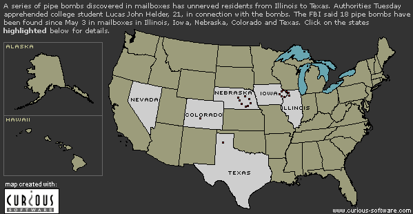
"With regard to the pipe bombing map, it would have been useful if one of us had obtained a more detailed location listing of the pipe bombs. I would have been glad to create a map. The maps the newspapers published were a bit crude. "You missed an opening to plug our 'Women in GIS' series in the letter from [Bruce] Wescott."
• Elaine Hallisey Hendrix at Georgia State University pointed out a few more publications that had effective maps of the smiley face. "You didn't look at CNN! Take a look at the map linked from this page. The Atlanta Journal Constitution also included maps. I commented to a couple of people on the circle pattern before we knew about the smiley face. I thought the bomber was drawing a larger circle and hypothesized that he would move toward across Texas, toward Arkansas...."
• Tom Tribble of the North Carolina Center for Geographic Information & Analysis wrote to share his evidence on women in GIS: "… I read with interest the comments about women in GIS, specifically that women are disproportionally represented in the field. I have always had the exact opposite impression. Perhaps because my boss for my first 17 years in this business, Karen Siderelis, is a woman. When I served on the Board of URISA in the early 90's, the Board composition was 6 and 6. And I think there was a women president 3 out of 5 years at URISA. Additionally, it seemed to me that attendance at the annual URISA conference always included a significant percentage of women. I can generate a long list of women with whom I have served on committees or otherwise worked. In fact, my impression over the years was such that I have commented to my friends outside the industry about the extent of the involvement of women in GIS. I even had my own theory as to why. Because GIS is such a (relatively) new technology, I thought that maybe women were able to get in on the ground floor before an old boys network could form.
• Jeffrey Laurich an instructor at Fox Valley Technical College Appleton, WI, adds his comment about women in GIS: "I would like to comment on the letter in GIS Monitor below regarding women in GIS. I work at a technical College where we provide software training to business and industry in (among many topics) GIS. I have noticed that MOST of my students attending introductory GIS classes are women. In fact, when I visit and work with GIS personnel at their workplace, I find that most of the people doing the mapping and planning work are women. There may be a majority of men working in civil engineering, but city planning seems to be predominately female. "On the other hand, it may be that women are busy mapping while men are busy attending conferences, making speeches and writing newsletters.;)"
• Andrew Zolnai, Petroleum Manager at ESRI, straightened out my reference to the new ESRI extension that links ArcIMS with ArcMap which I mentioned in discussing MapInfo Discovery: "...what you may be alluding to is not an ArcMap extension ...[but] rather the next step in enterprise GIS is ArcMap Server, the nascent merger of ArcGIS and ArcIMS which allows to publish on the web with full-featured GIS."
POINTS OF INTEREST • Martin McGarry has left Informatix Software Internation (ISI) to pursue interests elsewhere. McGarry headed up the company which now owns MicroGDS and had been supporting Classic GDS since Convergent Group ended development of the product some years ago. • Autodesk's overall numbers for the quarter were down over last year at this time: $229 million, compared to $246 million. Still, the GIS Division, which according to the announcement had a focus on homeland security and public works, showed year over year growth of 27% and net revenues of $27 million. The company still has a shot at a $1 billion year. Autodesk chief financial officer Steve Cakebread is leaving to join Salesforce.com as their chief financial officer. Autodesk is a customer of that company. • I learned this week that the panic over the potential cutting of MassGIS funding is over. The Massachusetts legislature passed an amendment to the state budget that will fund the organization. • Homeland Defense has become an industry. There are now conferences on how to procure federal grants and a free newsletter relating to the topic. And, yes, GIS companies are involved. • Satellite tracking of animals is far cheaper that the radio-collars used only six years ago. A 40 caribou monitoring system in 1995 cost $30,000; today using GPS, it's only $2,000. • Verizon is "mapping" its competitors and its own cell phone coverage by driving $270,000 cars full of cell phones and computers. I'll bet they'd be interested in a cheaper way. . . • Xybernaut, a wearable computer company that once tauted their hardware for field GIS use has found a new niche. It's computers are becoming key tools for special needs students. • Miss Israel, Yamit Har-Noy, competed in the national costume show for Miss Universe delegates in San Juan, Puerto Rico in a dress featuring a map of Israeli territory on the front and the Israeli flag in the back.
BUSINESS NOTES Snowflake Software announced its membership in the Oracle PartnerNetwork. ESRI recently signed an agreement with IBM to license MapObjects LT for inclusion in IBM's Query Management Facility (QMF) software. This new contract expands ESRI's product integration relationship with IBM. RouteMatch Software Inc. announced that it has joined ESRI's Developer Business Partner Program. Geographic Data Technology, Inc. will work with Intrado Inc. to develop and deploy new applications for use in a variety of location-sensitive services. Intrado provides solutions that manage and deliver mission-critical information for telecommunications providers.
� Contracts HNIT-Baltic GeoInfoServisas, ESRI's distributor in Lithuania, has won a contract to supply GIS and image processing software as well as related services to the Ministry of Agriculture (MoA) of the Republic of Lithuania. Intergraph Public Safety (IPS) has been selected by Adams County, Colorado, to provide a fully integrated computer aided dispatch (CAD) and mobile data computing solution. The contract award is valued at $1.28 million (US). Intermap Technologies Inc. received contracts totaling CDN $1,539,645 including one from The University of Alaska, Fairbanks. � Products Clark Labs announces the release of a major service upgrade to Idrisi32 Release 2 that includes an HDF reader and import/export routines for ERDAS Imagine .img and Earth Resource Mapping's ER Mapper .ers files. Maporama announced the launch of Maporama Logistic Solutions, the fourth component of its Maporama Enterprise Solutions product suite. This new module is designed specifically for logistics managers in the retail, distribution, and service sectors. Trimble introduced the GeoExplorer CE series, a Windows CE device with integrated GPS. The GeoExplorer CE series is rugged, aimed at field use. geoVue, announced the general availability of interVue, developed in conjunction with Allied Domecq QSR (parent company for Dunkin' Donuts, Baskin-Robbins, and TOGOs Eateries), to leverage handheld technology to provide a web-based, scalable solution for immediate results from field research across unlimited sites. geoVue projects that, for companies conducting 15 or more customer surveys per year, the interVue solution will reduce both time and cost by up to 50 percent. � Hires
WEEK IN REVIEW May 22 - McDonald's Chooses Image Compression May 21 - ArcGIS 8.2 Supports Visual Studio .NET May 21 - DigitalGlobe Commences Full Commercial Operations May 20 - GeoDecisions and IntelliWhere Partner May 17 - Dashed Hopes for Dashboard Electronics May 17 - ESRI Now Offers GIS Solutions for Linux Users
ADVERTISE WITH US
CONTACT
SUBSCRIBE/UNSUBSCRIBE |
