Letter, Points of Interest, Week in Review, Back Issues, Advertise, Contact, Subscribe/Unsubscribe
AUTODESK FOCUSES ON PARTNERS, PHASES OUT UTILITIES PRODUCTS Two GIS partners will be the key solution providers for those moving off these platforms. Cook-Hurlbert will incorporate Autodesk Utility Design functionality into Expert Designer 3, a product that is "GIS independent." Autodesk also noted that SophSys' Sherpa product line fills a similar need. Those using GenMap will be escorted to Autodesk's own GIS Design Server or Utility Sciences Corporation (USC) USMap, a product built on Autodesk Map. Several system integrators including Advantica Stoner, Isosceles Information Solutions, KEMA Consulting, and Linnet Systems are lined up to aid in the transitions. There will be a fee to upgrade to the new software, but an Autodesk representative noted in a phone call that the partners are planning to offer special pricing. Autodesk purchased Gentry Systems in January of 2001. The press release stated, "By acquiring Gentry Systems, Autodesk gains important front-end design capabilities specific to the electric utilities industry including job estimating, electric network design calculations, physical design calculations, and more." Now it seems Autodesk hopes to get out of that space and let partners in. To be fair, this is Autodesk, so most likely, the decision was made based on business logic: the investment was not providing the expected return. It will be interesting to see what software Autodesk might divest itself of in the coming months, and, in turn, to theorize with which partners the company may try to get reacquainted. To its credit, Autodesk is rather quick to stop the leak when it's clear a product isn't going to make it (consider World, for example). Still, Autodesk has a long history of acquisitions-some of which pan out, others which do not. Autodesk GIS Strengthens Alliance With Cook-Hurlbert to Expand Utility Solution Offering (Autodesk PR) Autodesk Acquires Gentry Systems, Strengthening Its GIS Solution for the Electric Utility Market (Autodesk PR)
His comments on solving the shortest path problem illustrate that he was truly a man ahead of his time. He noted, "This was the first graph problem I ever posed myself and solved. The amazing thing was that I didn't publish it. It was not amazing at the time. At the time, algorithms were hardly considered a scientific topic." I confess that I'd never heard the name before, but after spending a day at GDT, I appreciate how we take the idea of routing and shortest path for granted these days. Obituary/Appreciation (The Register)
Comments flew from all directions. They were sent as letters to the editor of a publication which published the press release and the related story. They were on Autodesk stock discussion boards. There were all kinds of issues: Did the operators have equivalent experience? (one was a product manager) Was the hardware comparable? (one had a graphics accelerator card, the other did not) Did the operators have the same level of software? (one used a professional version, the other an educational version) What does it mean that two Autodesk User Groups sponsored the event? There are two issues here. First off, is it possible to produce an event like this and make it "fair"? Unlikely. One company may be very interested in participating-and provide top hardware and staff-while another may simply leave participation up to a user. Finding jockeys with "equal" experience is tough, too. Is it fair to simply use "years of use" to determine ability? Not usually. One of the easiest things to make fair is hardware - it IS possible to prepare two boxes identically. The second issue is what attendees learn from these events. I learned one thing from this one (and I'm NOT a mechanical engineer): it seems the tasks that the jockeys were asked to do were reasonable. I've yet to see anyone complain that they were asked to do things that are not part of a reasonable day or week of work. And, that's ultimately what may matter to a purchaser: which of these tasks are important to you? We've all have the experience of sitting and watching a whizbang demo and thinking to ourselves, "But I don't DO that." To his credit, one of the demo jockeys actually said that. I have counseled many potential GIS buyers to figure out what they needed to do, and then go to the vendors and have them show how to do those tasks. That's why, though I hated the stress of formal benchmarks, I appreciated that the requestors had laid down what they thought they needed to see. I participated in a GIS shoot-out once. I don't remember much-there were four of us and we each demoed our product in front of a GIS conference audience. We pulled in some data and manipulated it in some way. What I do recall was one question that came from the audience: "What one thing can you say to convince me to buy your software?" That was interesting to me since I expected to hear "the company line." In most cases I did. One company said, "Because we are the best." Others cited specific technical capabilities. My comment was, "If it does what you need it to do, then you should buy it." Shootouts, like much research on comparing products, are very much about figuring out which questions matter to the purchaser. I hope that somehow those following this mechanical software shootout will see that through all the mudslinging. Inventor Beats SolidWorks in Independent Competition (Autodesk Press Release) Shoot-out Between Inventor and SolidWorks (Event review by SVAPU president) Shootout Not Fair, Says SolidWorks to VARS (Article at TenLinks) SolidWorks vs Inventor Debacle (Article at CADserver)
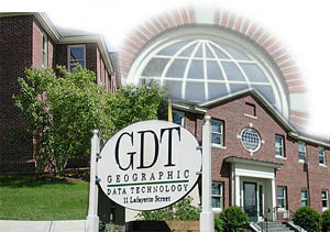
Don Cooke acted as president until 1994, and now, with the title "founder," is in charge of company vision. The role suits him well as he's quick to question assumptions about GIS, technology, and the marketplace. I got the sense from Cooke that the only truth is learned from the customers; they are the only ones who can dictate what GIS data is supposed to look like. I asked Cooke about a host of topics and we meandered around nearly every topic that touches GIS these days. Cooke considers himself a "critical user" of MapQuest a tool he uses a lot. He, perhaps like many of us in the industry, looks carefully at whose data is used in this, and other, online mapping services. GDT's data is used in MapQuest and Vicinity's MapBlast among others. Cooke is quick to point out that different data may be used in determining a route than is ultimately used to display the result. He also notes that routing results from engines online, and those of desktop products can vary quite a bit. I asked whether the algorithm or the data causes the disparity. Cooke argues that it's a bit of both and that the explanation for any situation runs along a continuum. One key is how the data is "interpreted" by the developer. GDT's roads, for example, are classified by Feature Class Code (FCC) which notes "impedance" to determine travel times. But one application developer may assume that a class code can support a 20 mph speed, while another assumes 40 mph. And, if the algorithm selects the "fastest" route, it may well avoid the 20 mph road, even if it's more direct. He also pointed out an idea that never occurred to me: perhaps some routing software puts travelers on the highway and avoids rural roads not only for speed, but also to increase the likelihood of cell phone signals. I suggested that it may be time for routing engines to use cell phone coverage as yet another variable for determining routes. Business people would certainly choose those routes from time to time! Cooke's first company, Urban Data Processing, founded in 1968, geocoded savers and borrowers at Chicago banks, illustrating some of the unfair practices in that industry. The ultimate result: new banking laws for Illinois, followed by the federal Community Redevelopment Act (CRA) and Home Mortgage Disclosure Act (HMDA). It's easy to sense that spatial disparity still creeps into Cooke's consciousness. He wonders about liability of routing if a "fastest route" might take a traveler through an unsafe area. As an example, Cooke quotes a description from a Popular Science article that describes "neighborhoods where police cars only travel in platoons." I asked about the future of in-car navigation. Cooke always rents a car with Hertz NeverLost system to examine the human interaction issues and, of course, to look for errors. On the whole he's reasonably impressed, but as someone who really knows data, he can see how small errors in data can lead to significant consequences for drivers. He laughs about people too trusting of technology who drive into a lake because the system says to turn right. On the other hand, he recognizes that a simple miscoded intersection can add miles to a trip. Cooke feels that the combination of navigation, car monitoring, and on-call assistance will lure consumers to telematics. "Dumb maps" aren't enough, he argues. But if the mechanical system of a car can "detect" that it needs a visit to the shop and "call ahead" either automatically or by having the driver speak to the dealer to schedule an appointment, and then direct the driver to the nearest shop, that's worth an investment. We moved on to discuss location-based services (LBS) and Public Safety Answering Points (PSAPs). These are the local, typically county level, emergency response centers that pass E911 calls to the appropriate public safety providers (police and fire departments, etc.). Not surprisingly, Cooke is curious about the datasets that the PSAPs and the responding organizations will use. How will they share data across boundaries, since for example, in some cases, the direct route may cross another county? Or what if one county shares response equipment with neighboring counties? And, in the long run, how will data be maintained? I've written about the company's Community Update Program in the past. That's GDT's online editing environment designed so that participating localities can provide updates in nearly real time. Cooke is realistic about the challenges to the program. First off, it's difficult, with all the other data updating on deck, to include these changes "quickly" in the master database. Second, some localities do yet see the incentive to participate. Still, the program is working and has steady support from about 100 municipalities across the U.S.
TOURING GDT The history of GDT plays out in a series of maps in a main hall. Back in 1994 the plots reflect single line, straightened TIGER data. The maps are not particularly pretty, but then, the goal was simply to provide a nationwide database for geocoding. A few years later the maps show points of interest and street names and start to look, well, like maps. This was the next phase: clients demanded data not only for geocoding, but also for display. The late 1990s were all about preparing the data for routing. All street intersections we marked with a node, and with further input, the nodes were given elevation so that underpasses and overpasses could be defined. Remember, just because a highway happens to cross a sidestreet on a map, there may not be an exit ramp there! The other big task of past years has been updating positional accuracy (how close on the map the road is to its true location on the ground). Nowadays, positional accuracy is very important for LBS applications and routing, but back in the early 1990s (the days of geocoding) that was not so important. The good news is that now imagery is far more available to enhance positional accuracy to the 5-12 meters that GDT customers demand. Cooke noted that "statistically guaranteed," one of the legal terms associated with accuracy, is his favorite oxymoron. GDT's map data resides in a BIG Oracle database called Orion. It stores all of "the data"-geometry and attributes including address ranges, turn restrictions, signage, and a lot more. Digital Map Technicians (DMTs) work in two shifts to make updates. The results are delivered to some customers monthly, to others quarterly, and sometimes, even less often. The Dynamap data for the whole U.S. these days is delivered on 65 CDs. The company sometimes uses SCSI hard drives for delivery, but to date, DVDs are simply not cost effective. The data is delivered in ASCII or SDE format for those who need monthly transactional updates. What was the coolest part of the tour? A few things caught my eye. GDT's editing software, BEGUILE (BEtter Graphical User Interface [than the] Last Example) is 100% custom and runs on UNIX. It has evolved over the years to address the exact type of edits required. The quick delivery of imagery to the DMTs is handled by MIT's image server technology and is very impressive. Detailed imagery allowed me, looking over a DMT's shoulder, to determine the direction of a one-way street by the orientation of the cars! The DMT could even identify car types by their roofs. This was all cool - but my favorite part was the library-a separate hallowed place with four full-time librarians, which holds the resources used to build Orion. Each hardcopy map or digital file is graded based on a reviewer's confidence in its quality. Some are stand-alone resources, meaning they are good enough NOT to need corroboration with another resource. A whole division of GDT called Research & Acquisitions (R&A) gathers and sifts these materials before they hit the library, which is adjacent to the floor where most DMTs work.
THE DATABASE IMPROVEMENT DEPARTMENT: THE HEART OF GDT
One question I had for Jim O'Gorman, the Director DID was "How do you decide what gets edited first?" There are several factors that include the company's overall plan for updating geographies, specific contracts from clients, and the appearance of particularly "good" data in R&A. DID basically has to take the ultimate priorities and make them happen. This year the group is working on several goals: determining the right tool for a job-be it a person or a software solution, insuring that the right DMT gets the right task, using resources "just in time," insuring good data using quality assurance by staff and automated checks (typically done nightly) and measuring performance. DMT's are expected to be both efficient and accurate in making edits, and are rewarded for doing so. Two years in a row, Business NH magazine named the company one of the best places to work in the state. And, yes, GDT is hiring! I wanted to know about how one could, for example, automatically check data to see if it is providing accurate routing. GDT spent some time creating tools for just that. Here's a clever idea: run routes between cities and compare the total distance to existing distance grids (those tables at the bottom of many paper maps). If there's a significant distance, it's likely that a possible turn is not, in fact, available in the road network. This and other automated tools help GDT test its road network for errors. I asked O'Gorman which information is the most difficult for R&A to track down. The answer: legal turn restrictions. Those are basically indicated by the "no left turn" and "no right turn" signs on local roads. They are rarely documented elsewhere. How does GDT track these down? Field workers can capture them, and more and more transportation organizations are taking videos of their streets, including signs like these. The sign inventory has become a high demand dataset because when providing door-to-door directions, many clients want to know exactly what the sign says, at say, an exit. GDT DMTs watch the videos and key turn restrictions as well as the text on signs into Orion. Part of the DMT job is following the GDT data model. The company has its own modeling team that defines such things as "What is a bridge?" I asked where the company's model fit into new content standards being developed by the Federal Geographic Data Committee (FGDC). GDT's model draws on de jure (juried) standards when applicable, but ultimately the company defines a bridge based on what the clients prefer. Cooke is a big fan of URISA's addressing standards and the National Standard for Spatial Database Accuracy (NSSDA), the standard released by the FGDC in 1998 to replace the obsolete National Map Accuracy Standard. The DMTs who work at GDT reflect the population of the Upper Connecticut River Valley. There are high school graduates who are looking to stay near home, some of whom are pursing degrees at the local colleges. Some are grads from Dartmouth, and others are older workers who are relatively new to mapping. Two are spouses of geography professors!
GDT'S BUSINESS MODEL GDT has certainly found itself a niche. And, it's likely it will be around for a long time. Cooke is pleased to note "I've been doing this for 35 years and its still not boring."
LETTER "Just a quick note to correct you-you stated that the acquisition of CAiCE was the first acquisition of application technology by Autodesk GIS-did you forget about the 2000 [actually January 2001] acquisition of Gentry Systems and their Utility Designer and GenMap applications for utilities? Hopefully this one will work out better for all concerned...." The editor responds: I did indeed forget that acquisition. I don't recall hearing much about the products save for the relaunches of them as official Autodesk products. Of course, I did hear more about them this week, as Autodesk outlined their demise.
POINTS OF INTEREST • In other Autodesk news, the company's magazine a will be morphed into a new publication Augiworld, for Autodesk User Group International (AUGI). Former a editor and Augiworld editor-to-be, Marilyn Law argues that Solidvapor-which currently publishes a-considered doing two magazines, but ultimately decided that there was considerable overlap, and chose just one. Since a was free and Augiworld is available free to AUGI members, and AUGI membership is free, for readers, it's about the status quo. Solidvapor also publishes the Partner Products and & Services online service that replaced the now defunct Autodesk Resource Guide. • The HP AnywhereYouGo.com website shut down July 30, 2002. It was a site devoted to mobile computing and carried a good bit about location-based services. Perhaps HP, which put up the money, feels that the knowledge level regarding mobile is high enough, or more likely, that there are plenty of websites covering that technology. • The future of multi-media messaging is the latest guessing game for analysts and others according to ZDNet Australia. Analysts are predicting 10 billion multi-media messages (MMS) a month worldwide within two years. The World Wireless Forum argues the number is more like 200 million. That doesn't mean that developers including Sony Ericsson and Autodesk aren't jumping in to MMS. • When I was in graduate school I remember discussing how thinkers, when trying to picture how space travel would change the world, took a look back to the nearest thing they could thing of, the explosion of the rail system. An interesting article from the BBC described how these days other thinkers are looking back to location-based phone services in Britain to try to tease out the future success of wireless access points for Internet connectivity. Though four companies were given licenses for this early form of "cell phone," none survived far beyond its birth in 1989. Will wireless access need to be ubiquitous, much like cell phone coverage, for the big move to that technology? • Many of you received an e-mail message from ESRI noting that Jack Dangermond had extended his response to URISA's GIS certification program after speaking with the URISA Certification Committee. The piece basically reviews the proposal in some depth addressing in particular Dangermond's concern over the "inclusiveness" of the process. I give ESRI credit for raising its concerns. Have any other GIS vendors or consultants stepped forward to raise issues or take a stand one way or the other? • GISBid.com reduced the fee for yearly membership to $89.95. That's less than 25 cents a day, if you do accounting that way. • MapInfo this week announced an extensive education program aimed at getting its software into colleges and universities. The announcement reveals an "an entirely new annual licensing system" detailed on the company website. The announcement follows a flurry of such announcements from Intergraph over the past few weeks. Both companies however are far behind ESRI, which has had such programs in place for years. I think it's interesting that both companies are aiming at education in the down economy.
� Announcements Intergraph Mapping and GIS Solutions newest Team GeoMedia Program, Registered Research Laboratory, has applications from more than 20 institutions worldwide and already has universities and laboratories participating in Austria, Belgium, Czech Republic, Slovakia, South Africa, and the United States. Universities and non-commercial laboratories are invited to submit proposals for the Team GeoMedia Registered Research Laboratory Program. Institutions chosen for the program will be required to submit a minimum of two research papers per year and in return receive a variety of Intergraph software. NovaLIS Technologies will host its first annual user conference this November 13-16, 2002 at the Adam's Mark Hotel in Daytona Beach, Florida.
EarthSat announced today that the U.S. Government awarded a Certificate of Appreciation to Mr. R. Peter Kollasch, Technical Project Manager of the GeoTools project. The award recognizes Mr. Kollasch for his exceptional effort in supporting GeoTools -- a multiyear, $1 million (US) contract to design software for regional agricultural area assessments. Leica Geosystems announced that its results for its first quarter of Fiscal Year 2002/03 were generally in line with its guidance of slower growth and lower profitability compared to a year ago. Total Company sales were CHF 177.9 million, off 12.5% in comparison to the pre-recession results of the previous year. Adjusted for the impact of currency fluctuations, sales declined by 5.8% year-on-year. Sales in Surveying & Engineering, the Company's largest division, declined by 9.6% during the first quarter, while Leica Geosystems' GIS & Mapping Division showed sales dipping by 26.7%. 8.7% of the decline is currency related, according to the company. Still, U.S. sales are up, suggesting to the company that the economy is turning around.Technical Committee L1 of the InterNational Committee for Information Technology Standards (INCITS) announced that it will begin work immediately on Geographic Information Framework Data Content Standards. The framework standards will address themes identified as needed by many applications for the National Spatial Data Infrastructure (NSDI). They support the Geospatial One-Stop, which is part of the Office of Management and Budget's e-government initiative to accelerate federal government improvements in effectiveness, efficiency, and customer service. Laser-Scan is working with national mapping agencies and other interested parties to develop a new, user-friendly automatic generalization product: Clarity. DigitalGlobe has recognized ImageLinks as the top reseller of DigitalGlobe's high-resolution QuickBird image data in the United States.
A delegation from MAPPS, a national association of private geospatial firms, met with senior staff to President George W. Bush on August 8 at the White House. Discussions focused on topics such as CIA Director George Tenet's recent memo to NIMA advocating the use of commercial satellite imagery and the need for a similar government-wide policy from OMB; Circular A-110 and the issue of public domain and private, licensed, copyrighted data; Federal agency duplication of geospatial activities; government competition with the private sector; and geospatial applications for infrastructure, resource management and Homeland Defense applications. PCI Geomatics and Supresoft Inc., a professional provider of technology and solutions for the extraction, processing, and application of geomatics data, are pleased to announce the formation of a new promotion and distribution agreement. This agreement establishes the equal two-way distribution of their popular geospatial technology products, allowing for greater international market coverage for both companies while presenting customers with new and highly compatible solutions for both analysis and visualization. James W. Sewall Company of Old Town, Maine, announced the formation of a strategic alliance with Harp Engineering, Inc., to deliver pipeline integrity consulting services. New federal pipeline integrity regulations and operating mandates have dramatically increased the demand on pipeline operators for current pipeline information and analysis. By combining Sewall's pipeline software expertise with Harp's consulting and engineering experience, this alliance will assist operators in addressing these mandates rapidly and effectively. The Open GIS Consortium, Inc. (OGC) kicked off the second threadset of its Web Services Initiative Phase 1 (OWS-1.2) recently with a four-ay meeting in Herndon, Virginia. OWS 1.2 will focus on developing new OGC interface specifications in the areas of image handling, sensor web enablement, service chaining, and feature handling, as well as, extending existing OGC interface specifications, and draft engineering specifications developed in OWS1.1 and other OGC Interoperability Initiatives. ESRI is offering a free course via its ESRI Virtual Campus titled Migrating from ArcView 3.x to ArcView 8. The class teaches GIS users about the differences between the two versions of ArcView and how the new applications in ArcView 8 enhance the software. New terminology and features in ArcView 8 are explained in the course, allowing students to competently and more effectively utilize the software. The Urban and Regional Information Systems Association (URISA) has chosen New York City's Mayor's Office of Emergency Management and NYC's Department of Information Technology and Telecommunications for an Exemplary Systems In Government (ESIG) Award. The technology award is for the City's successful emergency management solution, the Emergency Management Online Locator System (EMOLS) application developed by PlanGraphics, Inc.
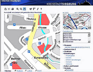
The town of Siegburg has equipped its communal Internet portal with a dynamic vector-based street map. With the aid of SICAD Internet Map Service (SICAD-IMS), the NetMap application can directly access the local government's official database. The street map queries and rapid access to the latest information has led to a massive increase in traffic on the Siegburg website. The Board of Directors of GIS in the Rockies 2002 announces that the workshop program is expanded by four additional workshops. Significant savings are available to those who register for the conference by August 15. The new workshops are:
ASPRS: The Imaging & Geospatial Information Society (ASPRS) and the Management Association for Private Photogrammetric Surveyors (MAPPS) are jointly planning a Fall 2003 Conference titled "Digital Terrain Data and 3-D Visualization." This program will be held in Charleston, South Carolina, October 28-30, 2003. TerraSeer has just released a geographic study of breast, lung, and colorectal cancer on Long Island, NY. Geoffrey Jacquez, Ph.D., and Dunrie Greiling, Ph.D., used TerraSeer Environmental Insight software to detect spatial patterns in these three cancers and compared these patterns to exposure to air toxics. They found no relationship between air toxics and breast and colorectal cancer, but there was a significant spatial association between exposure to air toxics that are known to cause lung cancer with the pattern of lung cancer cases. This study was commissioned by New York Newsday, a paper with a circulation of 700,000 on Long Island. LocatioNet and dynamicsoft Inc. announced their partnership to provide wireless carriers with new revenue opportunities by bringing to market a new class of services that combine location, presence, and messaging. Some examples: Automated "instant messaging-like" alerts could be sent to users when their friends, relatives, or colleagues are within proximity of their location. Similarly, a two-way instant message could be initiated to two people in a dating service whose profiles indicate a match, once they get within range of each other. In the arena of mobile commerce, automated "low intrusion" instant messages could be sent to wireless subscribers featuring specials from nearby establishments that the subscriber has opted into, such as coffee shops, restaurants, retail outlets, movie theaters and museums. Trimble and ESRI announced that ESRI will begin reselling Trimble's GeoExplorer CE series with its ArcPad 6.0 mobile GIS software. � Contracts and Sales. Trimble announced that the Japanese Geographical Survey Institute (GSI) has awarded a contract for the purchase of 381 additional 5700 Continuously Operating Reference Station (CORS) receivers and 346 International GPS Service (IGS) standard choke ring antennae to expand its GPS-based network. CompassCom Inc. has won the contract to provide an Automatic Vehicle Location (AVL) and Asset Tracking System to the City of Fremont, California. Fremont will use the CompassCom AVL system to track its fleet of Public Works vehicles. El Colegio de la Frontera Sur (ECOSUR) in Mexico has adopted the Idrisi software to monitor land-use change and simulate the effects of such change in the southern Yucatan peninsular region. Webraska has been selected by Vindigo, the leading service provider of location-based content and services for wireless and mobile devices, to provide driving directions for its location-based service. Geographic Data Technology, Inc., announced that Verizon will use GDT's street and address data as the Verizon corporate landbase for mapping initiatives. Verizon will incorporate GDT's Dynamap/2000 georeferencing database into a system designed to improve customer service, increase productivity, and streamline operations. MSN will use Avesair's mobile marketing platform to deliver advertisements, coupons, and other promotions to its worldwide readership of around 5m mobile users. MSN will resell this inventory on behalf of Avesair, including location-based placements. Vizzavi selected Webraska for location-based services via WAP. The deal has resulted in the joint development of a location-based directory service, to enable subscribers to find nearby businesses via WAP, and have their details sent to them via a reverse-billed text message. The service is dubbed "Find and Seek" in the UK. Municipal Software Corporation announced that Bulloch County, GA purchased CityView Enterprise in order to automate their Permitting, Planning and Code Enforcement activities. PlanGraphics, Inc. has been awarded a contract with the District of Columbia's Emergency Management Agency to develop a plan which will ensure that the appropriate GIS resources are available to all agencies and staff involved in emergency responses. Intergraph Public Safety (IPS) announced six new contracts awarded since July 1st. The new customers include North Wales Police, United Kingdom; the Isle of Man, British Isles; City of Des Moines, Iowa; Johnson County, Kansas; the City of Leawood, Kansas; and the City of Thornton, Colorado. The awards exceed $10 million. Intermap Technologies Inc., announced that it has received $13,356,000 in additional awards to previously announced contracts (June 10, 2002) for the provision of terrain elevation and image data using Intermap's proprietary mapping technology. This increase in both size and scope of work brings the total contract awards to $24,111,000 at current exchange rates. � Products Mapping Science, Inc. announced GeoJP2, the first image compression and management solution developed specifically for the mapping and GIS community. Built on and supported by an open standard (JPEG2000,) GeoJP2 will eliminate reliance on proprietary compression formats while introducing features and functionality never before available to mapping professionals. Scheduled for release in mid-September, GeoJP2 will provide support for most major image file types (including hyperspectral data) and will include features such as lossless compression, internal georeferencing and mosaic development. Mapping Science will release standalone viewers and an ArcView 3.x extension in the next few weeks, with new Server tools shortly thereafter. Introductory pricing for GeoJP2 has been set at $1995.00. MapInfo currently supports the file format at Version 7.0. Intermap Technologies announced pricing discounts on its archive S.E. Asian data, available through GLOBAL Terrain, Intermap's online terrain elevation data store. The reductions in price pave the way for new data acquisitions in the area, which Intermap will commence later this quarter. Current pricing for the S.E. Asian archive data, which includes the islands of Java and Irian Jaya in Indonesia, has been reduced nearly 40%. ComputaMaps has added global cloud-free imagery and updated its entire clutter database. The global imagery has been tiled and reprojected to UTM zones and is supplied as Geotiff files. ArcHydro: GIS for Water Resources, the latest title from ESRI Press, describes how a water resources data model, ArcHydro, is being applied within GIS technology to provide a wide variety of hydrologic solutions. Edited by David R. Maidment, an authority on water resources and GIS, this book presents ArcHydro concepts, components, and applications, and it is now available for purchase. ESRI Virtual Campus is offering Planning for a GIS, a 10-module course that explains how to successfully plan for a GIS implementation. The class costs $180 and was written by Roger Tomlinson.
CompassCom Inc., a provider of asset tracking and automatic vehicle location (AVL) solutions, announced the Incident Command Module (ICM) as the latest offering in the CompassCom suite of products. ICM is an add-on module designed to operate with CompassCom's CompassTrac and CompassTrac Mobile client software. Leica Geosystems' DNA10 and DNA03 digital levels provide rapid, accurate solutions for a wide range of leveling applications, from topographic and construction surveys to First Order leveling and monitoring. The DNA10, with accuracy of 0.9 mm per 1 km, is suitable for cadastral and technical leveling. The DNA03 provides 0.3 mm accuracy and is ideal for First and Second Order leveling and high-precision measurements.
geoVue, a provider of innovative location intelligence solutions, announced the general availability of iSITE Enterprise. The latest version of the company's base solution includes a newly customizable framework, customer branding, and demographic data processing up to 10 times faster than previous versions. Full Circle Technologies of Boston, MA, announced the introduction of VectorEyes, a powerful, easy-to-use, fully customizable, interactive, GIS viewing program that requires no installation or technical expertise to set up. The tiny program takes up virtually no space on a server and requires no applet plug-in, yet provides full featured, interactive, real time capabilities that expand the possibilities of how GIS information can be shared. The price is $3,900 per server. Swisscom Mobile has launched two new mobile data services, City Map and Route Planner, for users of WAP-enabled mobile phones in Switzerland, which enable them to call up location-specific map sections and route descriptions for viewing on their display. � Hires and Appointments
ADVERTISE WITH US
CONTACT
SUBSCRIBE/UNSUBSCRIBE |