Letters, Points of Interest, Week in Review, Back Issues, Advertise, Contact, Subscribe/Unsubscribe
SRC AND MAPINFO IN LAWSUITS Until this past July 1, MapInfo licensed SRC technology. SRC's Allocate, a demographic analyzer, and Solocast, a cluster analyzer, were sold as MapInfo TargetPro Demographic Analyzer, and MapInfo TargetPro Cluster Analyzer, respectively. Releases of TargetPro up to version 3.7 included SRC technology. According to the Times Union, when the deal ended, the two companies agreed to split renewals on the software. On September 10 of this year, MapInfo sued SRC for more than $100,000 for failing to hand over a percentage of the renewals. SRC maintains that there were no renewals, and that clients instead purchased SRC products, so that MapInfo was not entitled to any money. A week ago Wednesday, according to the Times Union, SRC sued MapInfo for $11 million arguing that MapInfo had taken SRC technology and sold it as its own. The Albany Business Review reports that the SRC suit is about "breach of contract, libel and disparaging Spatial's product." SRC's lawyer points out in the same article that while resellers waited for TargetPro 4.0 to ship, they used the old 3.7 version for demonstrations, which the company feels is an unfair business practice. SRC offered MapInfo resellers the opportunity to purchase Allocate/Solocast for their clients, to keep them on the same core technology. SRC reminded resellers that the company also offers comparable products to MapInfo's StreetPro, a nationwide database, and MapMarker, a geocoder. SRC highlighted the fact that its solutions fit on fewer disks than MapInfo solutions, provide extended features, and include newer data. Furthermore, SRC offered to pay the cancellation fee should users move from MapInfo products to SRC's. I'll suggest this may be part of the reason SRC claims there were no renewals. MapInfo introduced TargetPro 4.0 this summer. SRC noted that the product was built on SpatialWare (MapInfo's spatial database solution) and Microsoft's SQL Server database, and that it is, basically, a first release. MapInfo, in July, noted the product resulted from a partnership with Claritas, which markets it as iMARK. If you know your data vendor history, you'll find that odd. I looked up several 1998 articles in Scott Elliot's then shiny new Directions Magazine. (Elliot was the founder of Directions Magazine and data vendor Wessex.) In November 1998 the publication documents the "divorce" of MapInfo and Claritas. According to Michael Hickey, then vice president and general manager of MapInfo's Information Business Unit, MapInfo and Claritas had become competitors, so it was time to move on. Hickey explained, "There's nothing wrong with Claritas data. But through their acquisitions, Claritas acquired most of the industry. We couldn't succeed in the marketplace with TargetPro because [everyone we'd meet] were already Claritas clients or clients of one of their acquired companies." Also worth noting, SRC filed a lawsuit in 1999 against Claritas for breach of contract over an online demographics website called Survey of Buying Power Online. Claritas inherited the partnership when it purchased Market Statistics, a company that started the site with SRC. Claritas now hosts the site, but the service is no longer available. Visitors are pointed to Claritas Connect. SRC, based in Orange, California, was founded in 1997 and has just under 40 employees. SRC technology is licensed to ESRI, the U.S. Census Bureau, and Generation 5 (the CRM Gen5, not the CAD Gen5) and others. In an interview on July 3, 2002 with Directions Magazine's Joe Francica, SRC President Dean Stoecker explained that MapInfo was ready to control its own technology, so it was time to part ways with SRC. He argued, too, that SRC wanted to move toward "mainstream" micromarketing technology, which means greater reliance on COM, SOAP, and other technologies to link it to business workflows. He also mentioned that less than 5% of SRC's revenue was coming from MapInfo's licensing of technology. Francica followed up on July 15 with MapInfo, to get its side of the story. MapInfo argued that TargetPro was a key part of its future and thus the company should own the technology. Ownership meant better response to customers. The representative noted that the company had done more in that arena in a single year-without SRC-than it had during the four previous years. The representative suggested that this was similar to the company's choice to purchase CompuSearch in 2000. Later in the interview was a striking statement: "One thing that users should know is that any offer they receive to upgrade their TargetPro 3.7 to a new system is most likely not valid, especially in that the offer would not include MapInfo's 2002 estimates and projections or the PSYTE clusters that users have licensed." I don't believe the statement suggests the offer is invalid in terms of legality, but rather that the client would not receive comparable data. Neither attorney made a statement regarding the matter on Friday. MapInfo shares hit a 52-week low on Tuesday at $4.46, and were also low last week, though word of the lawsuit didn't reach me until Saturday. At this point, without the full details, it's hard to imagine how these two lawsuits will play out. However, MapInfo is having a challenging time with four consecutive losing quarters. Although restructuring and cuts are helping quite a bit, the last thing the company needs now is to drain resources with a lengthy lawsuit. Just to put the $11 million in perspective, consider that Intergraph received $250 million in the first Intel lawsuit, and that MapInfo reported a loss of $506,000 last quarter on revenue of $22.7 million. SRC is small and private, so it's hard to predict how prepared it is monetarily for a suit.
LETTERS Gayle Watson Manager, Public Relations at Leica Geosystems wrote: "I want to make sure that you are aware that historically we have offered that same service with many of our software products, including our flagship ERDAS IMAGINE software." Bob McIntyre of Intergraph Mapping and GIS Solutions sympathized with my sentiment that it's easy to collect free trials and never install them. "�a very astute comment�. Yeah, like I've never done that. ...Intergraph has always made free evaluation copies available through our website." John Ievers of CDR Group in the UK notes that: "MapInfo has offered free full evaluation copies of its software for years!!! Don't ask me how many years though!!" In addition, Simon Greener of GIS Manager at Forestry Tasmania had a question: "Was your intention on "The Free Trial Effect" to simply indicate that ESRI and MapInfo have joined the already existing companies offering free trials (eg Intergraph - GeoMedia; CadCorp's SIS; Laser-Scan's Radius) or that they are starting something new (which is patently not the case)?" The editor responds: Just so we are clear, my goal was not to list all the free evals out there, but to comment on two companies that are actively promoting them at this time. I will go so far as to say that if you are a serious customer and you can't get a free evaluation of software, you should find another vendor.� Amir Toister wrote to share a GIS definition found on the Web: "Groone's GIS 1.0 (14.7MB): GIS is a full-featured inventory control software with a focus on being user friendly. It maintains a database of all your merchandise along with stock amounts. GIS makes updating the inventory levels a breeze. GIS also allows you to track your receiving in the form of assignments and export in the form of invoicing. Customer information will always be at your fingertips with GIS." "What is GIS? GIS stands for Generic Inventory System. "BTW, a friend of mine bought papers of a GIS RFP. It turned out to be a 'Gas Insulated Switchboard' contract."
POINTS OF INTEREST � I attended the Autodesk GIS Exposition 2002 in Atlanta this week. However, Autodesk has asked that I not write about what I learned until Oct 2. So, look for details next week. � According to the Times, cameras on UK highways tracking speeding and confirming payment for "congestion charges" are the latest tracking devices that drivers are trying to "trick." A variety of gadgets are now on the market to "hide" license plates and thus avoid fees. One gadget puts a glass plate over the license which, when turned on, turns opaque. Other motorists are testing low-tech solutions, such as giving false registration information or smearing mud on plates. Fines for not paying the congestion charge of L5, run from L80 to L350. Intentionally obscuring plates may also bring a fine or even jail time. � The folks at Verizon Wireless are offering Vindigo-the product that formerly ran for free on a Palm device-on Get It Now phones. The service costs $3.75/month and provides access to regularly updated databases of restaurants and ATMs. This is a manual "location-based service" meaning you must key in your location to "find the nearest" or get directions. � Wired Magazine reports on undergraduates at UNC-Chapel Hill that worked on a project to make maps accessible to the blind, which use sound rather than touch. As the mouse is moved over different geographies, different sounds can be heard. I'll bet these folks could learn a lot from young video gamers and their use of sound for navigation through their fantasy worlds.
� Announcements GiveMePower Corporation announced an aggressive marketing promotion offering its development partners a 50% initial order discount on selected developer programs. The company is a rapidly emerging provider of desktop, mobile, and wireless computer-aided design (CAD) software and a Microsoft Mobile Solutions Partner. ESRI announced the program for its Seventeenth Annual European Conference, which is scheduled for October 14-16, 2002. ESRI BeLux is hosting the conference at the Floreal Club Congress Centre near the city of Bruges, Belgium. ImageLinks has been named to Deloitte & Touche's prestigious Florida High Tech Corridor Technology Fast 50 program, a ranking of the 50 fastest growing technology companies in the state. Rankings are based on the percentage of growth in fiscal year revenues from 1997-2001 (five-year period). The Huntsville Times, via the Wall Street Journal, reports that the judge in the ongoing Intergraph vs. Intel lawsuit has asked the two companies' CEOs to a meeting today to attempt a settlement. If there is no settlement, the judge promised he'd rule next month. CEO Jim Taylor of Intergraph will attend; Intel has stated that "someone in authority" will attend. URISA reminds potential attendees to register for the 40th Annual Conference. On the occasion of GSDI 6, Bob Samborski, Executive Director of Geospatial Information Technology Association (GITA) and Ravi Gupta, Editor of GIS@development Magazine launched the GITA proceedings on the www.GISdevelopment.net. The two organizations have agreed to make the www.GISdevelopment.net the global resource for GITA members and are working together per an agreement signed in February 2002. The Open GIS Consortium, Inc. announced that Autodesk, Inc. has become the first Principal Plus level OGC member. Full Circle Technologies, Inc. of Boston, MA has signed a cooperative marketing agreement with Virtual Town Hall, LLC of Portland, ME to resell Full Circle's VectorEyes GIS web mapping software to municipal government clients. In addition, Virtual Town Hall provides the hosting services and links to their web site for the data provided by their customers.Robert M. Scaer, president of GeoDecisions, a software-independent spatial information technology company, testified on intelligent transportation systems (ITS), homeland security, and the reauthorization of the transportation bill before the U.S. House of Representatives' Committee on Transportation and Infrastructure on September 10, 2002. Scaer, a member of the 15-member ITS Congressional Caucus Advisory Board, presented testimony on the application and benefits of the Intelligent Road and Rail Information Server (IRRIS) in providing solutions for ITS and homeland security. PCI Geomatics and RapidEye AG are partnering. RapidEye AG agreed to use PCI Geomatics products as the main platform for all of its geo-data processing and PCI Geomatics invested in RapidEye AG. RapidEye AG is establishing a commercial satellite-based geo-information service, focussed on insurance and food companies, farmers, national and international agencies and institutions, governments and others. ISTAR Americas and VARGIS LLC have teamed to deliver a one-foot, natural color TrueOrtho mosaic for the entire area of Howard County, Maryland.
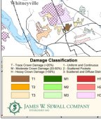
Under contract to the Maine Forest Service (MFS), James W. Sewall Company recently completed a second project to assess 1998 ice storm damage in Maine. At right, a section of the map. Intergraph Mapping and GIS Solutions announced that three industry-leading software companies (Keigan Systems, MapText, and Safe Software) have joined the company's Team GeoMedia Program as Registered Solutions Center (RSC) members. Municipal Software Corporation's software package CityView was awarded the Product of the Year Award from the Vancouver Island Advanced Technology Centre (VIATeC) at their annual Technology Awards banquet held on September 19, 2002. The Corporation of the County of Simcoe (County of Simcoe) was presented with an Award of Excellence at ESRI Canada's ninth annual Regional User Conference in Mississauga. Also at the conference, Paul VanZant, President of the Ontario Association for Geographic and Environmental Education, accepted an Award of Excellence on behalf of OAGEE for their contribution to GIS education. DigitalGlobe announced that MAPS geosystems has partnered with DigitalGlobe to become a reseller of QuickBird satellite imagery for the Middle East and East, Central, and West Africa. The Bentley Developer Conference will be held November 6-8, 2002, in Madrid, Spain, at the Hotel Melia Castilla. It will include a geospatial track. The Open GIS Consortium, Inc. (OGC) announced the U.S. Census Bureau will sponsor the second phase of the Critical Infrastructure Protection Initiative, CIPI-2. The Request for Quotations (RFQ) for this initiative will be available on Friday, September 27. QinetiQ and Parthus Technologies signed a collaborative licensing agreement for Parthus' NavStream 3000 GPS location platform for deployment in a number of areas including defense, telematics, transportation, and security/authentication. The Swedish company Idevio has won the prestigious European IST prize, which is given every year to the 20 most innovative IT products. Idevio received the prize for its technology that stores and streams vector based information - RaveGeo. � Contracts and Sales. Hutchison 3G will use IONIC products for their location based platform to produce maps, search and navigation tools, using the latest geospatial international standards. These include the Web Feature Server (WFS), using GML, and Web Map Server (WMS), as well as the IONIC Portrayal Pro Engine. These Enterprise Java components products conform with Open GIS Consortium, ISO/TC 211 and W3C standard interfaces, specifications and guidelines. Grizzli Mobile Systems, one of the leading providers of turnkey fleet-management services in France, has selected Webraska to integrate and deploy real-time navigation applications in their suite of productivity improvement solutions. Avenza Systems Inc. announced that Fleming College has equipped its Geomatics Institute in Lindsay, Ontario with 60 licenses of MAPublisher software. This implementation extends the existing usage of MAPublisher in Fleming's Geomatics program. Future plans call for additional MAPublisher seats to be installed in the college's new Institute of Geomatics at Fleming in Fall 2003. North West Group, the Canada-based aerial photography, photogrammetry, and remote sensing services company, has purchased an ADS40 Airborne Digital Sensor from the GIS & Mapping Division of Leica Geosystems. The system is one of several ADS40s currently used worldwide to collect high-resolution aerial imagery along with multi-spectral data. Kampsax, which was purchased by COWI on June 27 this year, has signed the company's biggest mapping contract yet with Ordnance Survey, Britain's national mapping agency. Over the next five years, Kampsax will supply an updated digital map covering a large part of Great Britain. Kampsax expects the order will total more than Euro 35 million worth of mapping and related assignments.
Autodesk, Inc. is working with eleven British Columbia municipalities to help improve service delivery of government services to residents and city workers through its Internet/Intranet mapping technology, Autodesk MapGuide. Municipalities using the technology include the City of Nanaimo, City of New Westminster, City of Vancouver, District of North Saanich, City of Victoria, City of Penticton, City of Vernon, Corporation of Delta, City of Prince George, City of Castlegar, and the Township of Esquimalt. ITIS Holdings, the provider of traffic information and location-based content to the telematics industry in the UK, has selected Webraska for the commercial deployment of all of its web-based tracking services. MacDonald, Dettwiler and Associates Ltd. announced the company has commenced work on a �1,000,000 contract to help the Local Authority in Slough, England modernize the processing of land information requests. � Products.
Microsoft Corp. and AT&T; Wireless Services Inc. announced a service on Wednesday that would let users look at a map displayed on a mobile phone to find driving directions, other users, and the locations of business contacts. For now the service is in trials. Rollout to business customers is expected in early 2003. Claritas Inc. announced Claritas BusinessPoint, an online data source that leverages the latest business information and customer analytical capabilities with the power of geo-demography. Eastman Kodak Company's Research Systems, Inc. (RSI) announced the availability of the IDL Student Edition Software. The IDL Student Edition is a fully functional version of RSI's flagship software product, IDL Software. James W. Sewall Company has developed HCACalculator, a modular software component for efficient and accurate calculations of high consequence areas (HCAs) along pipelines. Designed to work as an integral part of an enterprise-wide GIS or to stand alone, this ODBC-compliant COM component is designed to reduce the manual efforts that pipeline operators use to determine and manage HCA locations, minimizing the need for costly direct assessments of pipe. To meet compliance with U.S. Department of Transportation 49 CFR Part 192, operators are now required to identify locations that are of high consequence, including areas with high or concentrated populations, and facilities with confined, immobile, or difficult-to-evacuate populations, such as hospitals, schools, retirement homes, and prisons. In related news, James W. Sewall Company and Geographic Data Technology, Inc. (GDT), have partnered to provide high consequence area (HCA) location consulting services to pipeline companies nationwide. Schneider Corporation announced the establishment of TransGIS a group of related products and services for municipal and county agencies. Laser-Scan completed web-based flight information service for No.1 Aeronautical Information Documents Unit (No.1 AIDU) of the Royal Air Force. NDS is based on Laser-Scan's Gothic Web Mapper technology and this Internet solution will be hosted at Laser-Scan. It includes live data feeds.
INPHO GmbH, Stuttgart, Germany announced the release of SCOP++, the latest version of the SCOP digital terrain modeling software. SCOP++ effectively handles very large DTM projects. GeoConcept SA, European leader in Geographic Information Systems (GIS), announces the launch of GeoConcept Call Centers, a new call center solution to improve customer relationship management (CRM). Syncline, Inc. announced the release of an innovative web-based GIS data distribution tool, DataFinder Cafe. The DataFinder Cafe is a custom implementation of the MapCiti Data Extraction Module, an OGC compliant solution that allows MetroGIS (a GIS initiative serving the seven-county Minneapolis-St. Paul metropolitan area) participants and partners to securely view and distribute very large GIS data files residing in disparate locations without pressing and distributing CD-ROMS, a costly and cumbersome process. Navigation Technologies announced digital map coverage of Oman and updated coverage of the United Arab Emirates. Northern Geomantics, Inc (NGI) has completed a comprehensive security infrastructure system for the Maine Drinking Water Program's (DWP) Public Water Resources ArcIMS site. This popular site, originally developed by NGI in 1996, was removed from public access over concerns about potential water supply threats prompted by the events of 9/11. The newly revised, secure ArcIMS site is once again available online, and security features permit site access to DWP-approved users only. LAND INFO International, LLC announced the release of Iraq Topographic Maps and Digital Elevation Models at new limited-time pricing. The digital maps are fully geo-referenced for GIS integration. LAND INFO offers the maps in 1:100,000 and 1:200,000 scales. The Iraq datasets accompanies LAND INFO's growing map archive that now exceeds 140 countries worldwide. Motorola Inc., working with IBM Microelectronics, announced Motorola Instant GPS, a self-contained, single-chip, assisted global positioning system (A-GPS) receiver that the companies are designing for the portable device market. � Hires and Appointments. The Arkansas Geographic Information Office (AGIO) announced the addition of three staff members. Amrut Akhatri serve as the theme lead in the development of critical infrastructure and will be a member of the road centerlines team. As GIS Management Project Analyst, Joakim Jorwall will be responsible for assisting office staff with purchasing, program scheduling, coordinating mail outs, stakeholder database management, deployment of cooperative funding projects for GIS data development, tracking and managing cooperative funding projects, and research. Vince Guillet will be serving as the theme lead on the Arkansas Centerline File Program and will be responsible for coordinating with city, county, state and federal agencies to create a statewide centerline file utilizing the best available data. Scott Stephens has returned to Plexis Group as Director, following an 8-month hiatus. Choctaw Geo Imaging (CGI), a digital mapping enterprise of the Mississippi Band of Choctaw Indians (MBCI), has named Brenda Burroughs to the new post of Vice President of Sales & Marketing. VARGIS, LLC announced that Gerhard Sehnalek has joined the company as Director of Technical Services. In this position, Mr. Sehnalek has oversight of the Project Management and Production Departments at VARGIS. Prior to joining VARGIS, Sehnalek was the General Manager for East Coast Mapping in Bedford, NH. TIMMONS announces the appointment of Edward A. Singer, P.E., Senior Project Manager and Assistant GIS Manager as a Principal and Stockholder in the firm.
ADVERTISE WITH US
CONTACT
SUBSCRIBE/UNSUBSCRIBE |