Letters, Points of Interest, Week in Review, Back Issues, Advertise, Contact, Subscribe/Unsubscribe
ESRI BUYS A STAKE IN SICAD Daratech (pdf) cites SICAD as holding 6% of GIS software revenues worldwide, totalling 59.5 million in 2000. SICAD is one of the larger of the smaller players hovering in the 6-8% range in the market, along with MapInfo, Autodesk, and GE Network Solutions (Smallworld). Interestingly, RWE Gas was recently featured in GE Network Solutions Connections magazine (pdf) discussing its Smallworld implementation. The writing was on the wall for this purchase. Last year AED decided to port its cadastral applications to ESRI technology. The motivation, in part, was a partnership between AED and SICAD to develop a joint solution for the ALKIS standard (official land registry information system) based on ESRI and Leica Geosystems technology. The press release from May of this year states "the worldwide sales and partner network of ESRI, Leica Geosystems and Siemens AG will provide an even stronger international market presence underlining the assured future and close customer contact of the associated companies." Germany is known as a country that truly prefers homemade technology. That's one reason that SICAD has maintained the status in the worldwide marketplace that it still owns today. The ever-closer relationship with ESRI that AED developed was perhaps the only way to wean the state and local GIS user, as well as utilities, of SICAD and move them toward ESRI. This whole play, no matter who instigated it, is quite clever. Also of note: there are no other "larger" players left for ESRI to charm. MapInfo, Autodesk and GE Smallworld will hold tight to their customers. That leaves ESRI with a few companies with 2-3% of the market to consider acquiring down the road. What does this mean for the industry? This investment can be viewed as a reshuffling of the market. The number of companies able to compete against ESRI is dwindling. Intergraph, according to Daratech, in 2000 held the #2 spot, with 16% of the software market. With SICAD's 6% moving, I'll argue in the long term, to ESRI, the gap between ESRI and Intergraph grows.

MICROSOFT BUYS VICINITY Ted Johnson, Corporate Vice President at Microsoft said, "this acquisition will accelerate the adoption of location-based technology as a valuable ingredient of mainstream enterprise application development." Microsoft, as I see it, was not looking for technology in the acquisition, but rather a strong customer base and a staff with experience selling mapping services. Microsoft does have a few customers for MapPoint .NET, the best known of which is Dollar Rent a Car, but I suspect the company has had a tough time breaking into the world that is owned by Vicinity and MapQuest (now owned by AOL Time Warner). Vicinity, founded in 1995, has 117 employees in Sunnyvale, California, and Lebanon, New Hampshire. Microsoft expects to hire many of the Vicinity employees, but admits some overlapping positions will cause layoffs. MapBlast! will be phased out in favor of Microsoft's MSN MapPoint mapping website. Vicinity executive Teri Dahlbeck explained in a CNET article that the offerings are complementary: Vicinity offers tools for data analysis and marketing use that MapPoint lacks. Microsoft's forthcoming customer relationship management solution, MSCRM, expected later this year, may one day draw upon Vicinity technology. The CNET article noted that neither company's software tracks the movements of consumers. I can only guess that someone at the press conference asked that question. Michael Graff, general manager of the MapPoint business unit did note that the acquisition will help with wireless location-based services. Microsoft partnered with AT&T; Wireless earlier this year to provide such services. Vicinity was likely to get squeezed out in the long-term fight between Microsoft and MapQuest, so this was a safe way to survive. And, $96 million-for Microsoft-is a drop in the bucket.
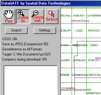
DATAGATE: A NEW DATA SERVICE
First I had to register and download the software (14.7 Mb). Many of the other data services (free and paid) require no download, so I found this interesting. More on this later. The download file is called "trial.exe" which could potentially get confusing for those who download lots of trial software. The downloaded file is a zipped executable, which when unzipped, is the install. The software installed without a hitch. I didn't receive the authorization code needed to test it right way and later learned that this is not an automated system. So, if you do the download the trial version at 2 a.m., don't expect the code right away. The software presents a vector map of the U.S., with tools to zoom and pan to the area of interest. As you zoom in you find more detail - down to the names of the quads. That, in part, explains the large download: 30 Mb of data is delivered to feed the application. I successfully selected a quad by pointing to it with the selection tool.
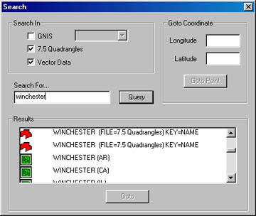
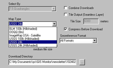
There is also a search tool to find the data of interest - but it is not a geocoder. Seekers can search by quad, Geographic Names Information System (GNIS), latitude/longitude, or something called "vector data" which includes "data labels" according to the help. I didn't use the GNIS because to do so you must download the data files of interest (by state) from the company's website. That's done to keep the download small. At first, I didn't find the instructions on how to use GNIS on the main download page - but they are there. I did successfully query on vector and quad. The results are listed, along with a "Goto" button, and include the quad or state as appropriate. When I searched on "Winchester" for example, using both quad and vector, I found 22 quads named Winchester and a host of "vector data" occurences - which I believe were the same 22 again. I was surprised that once I clicked Goto on the search tool, the search dialog went away. When I zoomed to the wrong quad, I had to restart the query tool and recreate my query. Another challenge: there is no option to zoom back out the extents of the U.S. The Settings dialog is used to select the type of data and the format for download. That was not intuitive to me. I expected the data options to be listed in the large dialog to the left of my map, but that's for the quads selected. The format tab on the settings dialog provides the options: JPEG or ECW, quality (1-99), tiling options if needed, CD delivery, MapInfo (TAB) or ESRI world file for georeferencing. You can also, optionally, sew data together from one or more quads. I asked about the "quality" slider. I turns out that one complaint of those who purchase raster data, especially online, is the quality. Most vendors decide on an optimal quality that gives decent detail and decent download times. Spatial Data Technologies has, in that past done that, too. But, customers wanted the option to get the best quality they could - especially for large plots. So, the company provides the option, and so long as customers have the time or bandwidth, are charged no more for higher quality.
The Admin tab on the Settings dialog is not supported in the evaluation version, but after some playing I learned that that's the place to control the display of data on the DataGATE application - setting colors, scale dependencies, etc. You can even add your own data (in shape files or DLG) to overview map. That can then be used to define selected areas. Also interesting, my authorization code and password were in plain site on the Authorization tab. I was told that in the full version, it is concealed. I selected the 24K quad (what many in the industry would call a collarless digital raster graphic, DRG) for my area, the JPEG option, a quality of 50, and compression "on." The 4.5 Mb download began. A status bar at the bottom of the DataGATE app ticked away. There is no way to preview the data - so if you chose the wrong quality, I suppose you are out of luck. After a good ten minutes (I made lunch) the download completed and the status bar said "creating new file" for a few minutes. Then I received a pop-up saying the download was complete. I ended up with a 9 Mb jpeg with a .jgw (jpeg world file for ESRI software), a .tab (file for MapInfo) and a .prj file (for ESRI software). When I asked I learned the 4.5Mb reported to me was the compressed size - the size during transfer, not the final size of the file I'd receive. And, when I saw "creating new file" the client software was uncompressing the file. I also learned that different compression schemes are used for the different file types. I asked John Hafnor, Communications Director about the advantages of DataGATE over other systems. He suggested that these fall into four main Categories: ease of use (being "three clicks from data"), being client-based (which provides a better viewer than available through a browser), speed, and finally, cost. Other distinguishers: the ability to select data based on user's own data, automatic formatting for ESRI or MapInfo, and the ability to license the system for use or resale. I do understand the need for the 14 Mb download now - this service uses your computer to do all the searching on your machine, not on the company's server. While that certainly does speed things up, you may run into some issues. For example, in the help it notes that where BLM maps are not available, "the USGS 1:100,000 scale maps may be substituted." The system does not warn you of that, so you may end up with unexpected data. There is room for improvement. I'd like to see a stronger search tool and a more intuitive interface. As for cost, it's tough to compare one vendor to another as some charge by quad and others by download size. Spatial Data Technology staff informed me that an "a la carte" option is in the works that allows downloads of only what you want (no prepaying) based not on file size, but data type. I do think the system will be more attractive as more data layers are made available, as is the plan.
OFF TOPIC: SPAM ELIMINATOR I read about ChoiceMail some months ago, I believe in the Wall Street Journal, on a plane. I thought the idea was a good one - and when I started to receive permission notices from some of you readers (who all let GIS Monitor "in," I'm pleased to say) I figured it was time to check it out. ChoiceMail is not a service, but software you buy for $39.95. A two-week trial is free. Here's the idea: ChoiceMail sits between your mail server (perhaps from your ISP, in my case my own mail server) and your mail client (in my case Outlook) and acts as a security guard. It essentially asks "Friend or Foe?" if the mail comes from someone not on the "white" list of "friends" already given permission to pass. That white list comes from your address book, which is easily uploaded. The "friend or foe" message asks the person why they want to contact the recipient and uses a clever scheme to insure it's a person: it asks the person to key in the numbers presented in a raster picture. The idea is that this is easy for people to do, but tough for machines to do. When the reply comes from the potential sender, the receiver has the choice of saying "ok" - which adds the sender to the white list, "no" - which adds the sender to the "black list" or ignoring it, in which case it is eventually thrown out. I had a bit of trouble understanding how the whole thing works - and I needed to since the install did not automatically configure my system (which includes many e-mail aliases, Norton Anti-virus and Zone Alarm). Here's how I understand it: the mail program (Outlook in my case) uses a new account that talks to ChoiceMail. ChoiceMail stores all the ISP info, account names, and passwords. ChoiceMail talks to the ISP. Then when messages are given the green light, ChoiceMail passes them on to the mail client - where rules are applied, if applicable. That's important to me since I use rules quite a lot in Outlook. The other challenge was making sure Norton Anti-Virus was operating. Initially it was not, which I learned when during my weekly scan, I had, for the first time, remnants of the Klez virus. So, I had to figure out where Norton sits in this chain of programs. The answer is that Norton's scanning happens before ChoiceMail - which makes sense - since you don't want virus-laced messages on the machine at all - in ChoiceMail - or an e-mail program. ChoiceMail works with most POP e-mail programs and the company is working on a version for Hotmail and other Web-based services. The software did the job: In two weeks I received zero spam! Only one person (a client it turns out) was offended when he received the permission notice. He pointed out that I should OK the whole domain for his organization. While I did do that, I did so with trepidation since I have received spam from the domain in the past. One sender, to my amusement, actually explained that he wanted to arrange to place large amounts of money in my bank account from his account in Nigeria. That person is now on my black list! Technically, the software can be a challenge. I suppose under "simple" circumstances the automated configuration will do the job, but I had to do it all manually. The help is a 55-page PDF file, which I found myself searching quite a bit. If you do chose to install ChoiceMail, be sure you understand how your mail currently works. If you do not, invite a friend who does to help out on the install. I'm pleased to say I figured it all out by myself, but it took some work.
LETTERS A reader has more questions: "Excellent reporting! It would be interesting to find out through FOIA [Freedom of Information Act] whether Pictometry was sole source qualified bidder for the Mass Highway contract. The contract value appeared to be $1.9 million." Another added some more information to my findings: "Very nice article, good job!!! A couple of interesting things that were not mentioned: "Pictometry primarily licenses its data for 2 years. At the end of those two years you can either pay 10% more and own the old imagery (I'm not sure if that is the ortho views only or if it includes their software) or pay again and use it 2 more years. "I believe the only true link into a real GIS is a TIFF file of their orthogonal view, none of the oblique stuff is exportable into a GIS. They can bring shape files into their software and drop them onto their images but there is little or no GIS functionality. "It really is not a good deal for the taxpayer, and the argument that is made in the Hartford article that they are competitively bidding the project is true on its face but practically it is a sole source. Pictometry has some sort of patent on the oblique image integration and the Mass Highway Department RFP was written specifically to this. No one is going to waste thousands of dollars preparing a proposal that they know is wired. "The sad part is that this endeavor siphons precious funds away from truly beneficial and lasting imagery efforts and risks spoiling the publics appetite for GIS and imagery as a whole." Jeff Thurston of Integral GIS in Berlin, Germany, one of my favorite writers in the GIS arena, worked with concepts similar to Pictometry's in his thesis. "Interesting article about Pictometry. I fiddled with what I called 'Vertical GIS' in my thesis. So, when I read your article, I thought hmmm...someone finally has the idea resolved. Too bad they have not pursued it more. They need to use GPS and image analysis, then they could have GIS functionality. Needs a bit more work. "The use for this is tremendous. People who look at historical photos would use this to analyze historical landscapes. Those pictures are always oblique views. People like National Parks. Another good article Adena. Caused me to remember some past work." � Peirce Eichelberger, of Chester County, PA, and president of URISA, passed on some interesting road names in response the ones in Mocksville, NC, I mentioned last week. "You would laugh at some of the street names that people have been bringing to the URISA 'Street Smart and Address Savvy' conference. We have a contest and a prize for street names in various categories. Recent winners include This Way and That Way, this year we had 2 1/2 Street that was the street name!, Four Wheel Drive, The Road to Hell (in Texas) and one of this year's winners Moose Turd Road, another good one was Finally My Way..........175 addressing fanatics got together in Portland, Oregon this August 11-13."
POINTS OF INTEREST MicroStation GeoGraphics v8.1, the CAD-based GIS, will include a Visual Basic interface, GeoSELECTools integration and OLE DB (database) support. MicroStation GeoOutlook, v8.1, the "viewer," will include a Visual Basic interface, 2D editing toolset, Oracle Spatial query capability, read/write database support and a concurrent licensing capability. MicroStation Descartes v8.1, the imaging product Bentley purchased from HMR some time ago, will include digital rights/digital signature adherence while MicroStation I/RAS B v8.1, the imaging product Bentley acquired from Intergraph more recently, will include full support for I/RAS B v7.1 functionality for the MicroStation V8 platform and a new square tool for image alignment. MicroStation GeoWater/GeoWasteWater v8.1, a solution for the water community, built on MicroStation Geographics, will include a new user-configurable data schema. � According to Wireless Newsfactor, Portable ultrawideband (UWB) radar units are being tested for military use. The technology, also known as ground-penetrating radar (GPR) is widely used to find underground pipes and look for subsurface defects in runways. The technology uses the principle that if enough signals, in different frequencies are sent out, some will penetrate each of the different materials. Enough bounce back from the different materials to create an image. One new innovation: a system that scans sideways, and can cover far more area, though in less detail. Environmental Mapping Canada is testing that type of sensor to find "fake" scuds this fall. Geophysical Survey Systems, in New Hampshire uses a system in a vehicle, which, being so close to the ground can more quickly capture information up to 30 meters away. The system is used in the military - and in archeology. Another system under development uses UWB to track people or objects. One suggested use: tracking firefighters inside buildings. � Digital Angel Corporation, one of several outfits offering tracking devices for people and things based on GPS made an interesting announcement this past week: it was going to use GSM/GPRS protocols (those used by AT&T; Wireless, Cingular Wireless and T-Mobile). Until now, the company used the services of only AT&T; Wireless. Down the road the company will support CMDA, used by Verizon and Sprint. What's odd to me about this announcement is that instead of adding GPS to a phone, this company is adding a phone (Internet ready phone) to a GPS. The big news is that the combined chip is quite small and should shrink the current two-piece device. � I was pleased to find this week a real live review of one of these tracking devices. The one reviewed in the Mercury News was from Wherify. I found the following points interesting. The wireless connection is supplied by Sprint, something not noted in the product literature or website. The basic plan ($24.95/month above the $399 for the device) includes 20 Internet "locates" and 3 phone locates. Mike Langberg, the author, was impressed with the locator's ability to find him in the window of a Starbucks. The map and aerial photo put him within 30 feet of his actual location. The location had healthy GPS and Sprint signals. Another coffee shop - but far away from the window gave good results, too, that time via phone. Part of the reason the company uses Sprint's wireless system is to act as a backup for when there are not enough satellites for a good GPS fix. The system is supposed to provide the address of the nearest cell tower. That'll work - presuming there is a Sprint signal. The author notes his concerns as price ($400 + $300/year for service), a 90-day warranty that notes that the watch-like device isn't supposed to be banged into objects or come into contact with sand or dirt (did I mention this is aimed at children?), and his wonderment at how much of the company's $25 million in venture capital is left. He notes that the company's principal competitor, Digital Angel (see above), is on shaky ground, having sold only 100 of its devices and showing a loss of $24 million on sales of $17 million for the first half of 2002. � Back in September, the National Imagery and Mapping Agency (NIMA) held an Historical Imagery Declassification (HID) Conference. The conference was a NIMA-led effort with other Intelligence, Department of Defense and civil organizations to review and declassify Keyhole (KH) imagery from the KH-7 surveillance imaging system and KH-9 mapping system. It also marked the official transfer of the original satellite imagery from NIMA to the National Archives and Records Administration. The high-resolution KH-7 surveillance imaging satellite, flown from July 1963 to June 1967 and the lower-resolution KH-9 flown from March 1973 to October 1980 were devoted exclusively to gathering information for mapmaking, and collected imagery. The United States Geological Survey's EROS Data Center (EDC) in Sioux Falls, South Dakota will host the public data which will be available for review on its website, prior to ordering. � A recent article in the Boston Globe highlighted a few local location-based businesses including GeoVue and MapTuit. The one I'd not heard about was Newbury Networks, a company looking to use WiFi to provide different content to people in different locations - even within the same building or room. One of the company's projects, at Dartmouth College's Thayer School of Engineering, allows faculty to share specific information with only those in the classroom (and turn off Web access/e-mail/instant messaging). My immediate thought - I'll send my mobile device with a fellow classmate to get the electronic notes and I'll sleep in! Other possible uses: patient records "broadcast" within a hospital room. � A commentary in the Charlotte Observer referred to an article in the The Atlanta Journal-Constitution (you must pay to read past issues, including the article in question) that argued that the sprawl in Atlanta is so bad that singles are refusing to date those more than 10 miles distant. In the Constitution article "an Atlanta psychologist said presorting by geography is 'profoundly shallow.' Or lazy." The Constitution article referred to those "out of bounds" as "geographically undesirable" or GU. I recall reading studies in grad school about how brides and grooms in Pennsylvania tended to stay within their valleys - not travel back and forth across the Appalachians. Geography matters and the principle of least effort is alive and well! � A U.K. consulting firm, BWCS, said uplink time difference of arrival (U-TDOA) offers greater accuracy and consistency over rival location technologies. The study suggested that installing U-TDOA could bring in 4x current revenues. Recall that last week I reported that Cingular Wireless had dropped enhanced observed time difference (EOTD) for U-TDOA. � If Korea is any indication, the producers of phones with GPS and color screens are waiting for services that demand them. Samsung introduced the first such phone to the country in August and says sales are beyond expectation. LG Electronics is waiting until next year, pointing out that Japan, which already has location-based services, hasn't seen a huge demand for such phones. � I noted the The Ekahau Positioning Engine (EPE) 2.0 last week, with the wrong URL. The correct one is http://www.ekahau.com. The company's product uses WiFi to locate objects/devices within about a meter. The company hopes it will be used in, for example, shopping carts in the supermarket that tell shoppers of nearby specials, or warehouses to help workers find needed equipment. The cost, the company argues, is so low that using the network only for location is quite feasible. The name of the company? It's derived from the god of travelers and merchants in Mayan mythology. � A new map of the world produced by a team of scientists from the New York-based Wildlife Conservation Society (WCS) and Columbia University's Center for International Earth Science Information Network (CIESIN) shows man's "footprint" over three quarters of the planet's surface. The map was published in the scientific journal BioScience and the researcher note that the work was only possible because of increased access to global datasets on roads, land use, and human population density in recent years. The data sets are available for download.
� Announcements SPOT Image has signed a SPOT data reception agreement with the Canada Centre for Remote Sensing (CCRS) to supply its US subsidiary SPOT Image Corporation with improved service, and imagery from the new SPOT 5 satellite. The online ESRI Virtual Campus Library, home to a bibliography of works related to the geographic information system (GIS) field, now features more than 20,000 titles. The "Call for Presentations" for the 2003 Bentley International User Conference, May 18-22, in Baltimore, Maryland is available. Abstracts are needed by December 1, 2002 for consideration. DCSE, a leading provider of GIS products and services, and Metropolis New Media, a provider of comprehensive managed hosting and co-location services for geographic information systems (GIS), today have announced a business partner relationship. The DCSE sales force will begin to offer an option for packaged pricing of a hosted version of MapLibrary. Mississippi State University has merged its Remote Sensing Technologies Center (RSTC), Water Resources Research Institute (WRRI), Visualization, Analysis, and Imaging Laboratory (VAIL), and Computational Geospatial Technology Center (CGTC) to form the Geospatial and Natural Resources Institute (GNRI). Ordnance Survey has introduced a nationwide network of retail outlets that delivers customized site maps straight to building professionals' desktops. Ordnance Survey Options outlets stock the national mapping agency's complete range of business graphic products, available in store or accessed by customers through a dedicated web browser. Avatech Solutions announced its free Geographic Data Technology, Inc. announced it will participate in MapInfo Corporation's grant program to assist small to medium-sized municipalities in developing and deploying Homeland Security/Continuity of Government plans and initiatives. One hundred grant recipients will receive MapInfo's location-based intelligence software along with GDT-based street and address databases and address matching tools. Dr. Roger Tomlinson of Tomlinson Associates Ltd. was presented with an Award of Excellence at ESRI Canada's Regional User Conference in Ottawa. Visual Learning Systems, Inc. (VLS) announced a partnership with � Contracts and Sales Harvard Design and Mapping (HDM) of Cambridge, MA, and Washington, DC, has announced that it has been awarded an SBIR contract with the Centers for Disease Control and Prevention (CDC) to develop a GIS-based system for Rapid Population Assessment in Complex Humanitarian Emergencies (CHE). The Transportation Group for Autodesk, Inc.'s GIS Solutions Division today announced that the Oregon Department of Transportation (ODOT) has selected CAiCE Visual Survey as its standard survey software solution. MacDonald, Dettwiler and Associates Ltd. announced today that the company's Earth Observation team has been awarded two Information Systems contracts by the Canadian government. The first is to build a planning and scheduling system for satellite data acquisition and reception at Natural Resources Canada's (NRCan) Canadian Centre for Remote Sensing (CCRS) facilities in Saskatchewan and Quebec, including a new capability to support RADARSAT-2. The second contract is to build the system that controls satellite data reception at those facilities. The University of Michigan became the 42nd University to purchase a site license of TerraSeer software. Terms of the site license were not disclosed. Boeing Autometric has received a $16.6 million contract from the National Imagery and Mapping Agency (NIMA) to produce topographic data collected during a space shuttle mission. Cape Nature Conservation (CNC) of South Africa, recently purchased a license of ER Mapper 6.3 from Andrew Terhorst Consulting CC, South Africa. DM Solutions Group Inc., a Web mapping solutions company, announced that The Atlas of Canada has chosen DM Solutions technology as a key contributor to the launch of the new Atlas of Canada on the Web. Leica Geosystems recently supplied eight high-precision GPS monitoring stations for the West Antarctic GPS Network for use in measuring crustal motions of the bedrock underlying and surrounding the West Antarctic Ice Sheet. � Products. IntelliWhere, a division of Intergraph Mapping and GIS Solutions, launched the new Mobile Workforce Starter Kit, an out-of-the-box solution that enables organizations to automate the delivery and use of spatial and asset data to field crews using personal digital assistants (PDAs). The starter kit provides a discounted software bundle of industry-proven PDA mapping and GIS management tools - IntelliWhere OnDemand, IntelliWhere LocationServer, and Intergraph's GeoMedia software - for the rapid deployment of spatial intelligence for any organization with a mobile workforce. Spatial Insights, Inc. has announced the availability of a web-based hosted service for online proximity analysis. The service was developed in conjunction with OpenOSX began shipping its Grass GIS 5.0.0 CD. This is the first stable version of Grass available for Mac OS X, and it now includes a native Mac OS X Aqua interface on the Carbon port of the Tcl/Tk interface. ERDAS IMAGINE V8.6, featuring an extensive list of notable enhancements including a Spectral Analysis tool for hyperspectral image processing, ESRI Geodatabase support, and significant improvements to the IMAGINE Geospatial Light Table(GLT) interface, will ship during Quarter Three (October- December) 2002. GeoGraphs Systems Corporation announced the release of Geo-Colors Lite, an affordable GIS Software that works inside MS Internet Explorer. The Software has the same capabilities as GeoGraphs Geo-Colors, but is restricted to file sizes of 500 KB. Microsoft released Streets & Trips 2003, the newest version of its consumer mapping and travel software. The new version, which costs $35, covers 6.7 million U.S. and Canadian streets and highways and more than 1 million locations, such as theaters, hotels, ATMs and banks. TatukGIS has released the GIS Developer Kernel toolkit as an ActiveX control for compatibility with Visual Basic, Visual C++, Visual Studio .NET products, and scripting languages, as well as Borland Delphi and C++Builder. In terms of framework and functionality, the ActiveX control is highly similar to the Delphi/C++Builder VCL version of the Developer Kernel, making it easy to port a DK based application between development environments, e.g., Delphi, C++Builder, Visual Basic, Visual C++, .NET, etc. A free v.7.2.2 trial, along with 20+ ActiveX and .NET samples and a tutorial are available. Research Systems, Inc. (RSI) released IDL 5.6, a data analysis, visualization and cross-application development software. The new version adds a host of new features that increase performance and flexibility, and offers the option of a Personal Use license. The Personal Use License enables users to install and license IDL Software on up to four separate computer systems that share a common operating system. TRIUS, Inc. announced SmpMapX, a GIS/Mapping engine centered around a Windows Active-X control. The control is distributed with a extensive sample data set, and additional data sets (including a full USA coverage data set derived from TIGER/Line 2000) are available from TRIUS, Inc. For availability, pricing, and a free evaluation copy visit the website. MapInfo and strategic partner Red Hen Systems jointly announced the release of MediaMapper ELITE, the only available technology that enables location-based video and digital still imagery to be automatically embedded into mapping applications. Developed in conjunction with the Department of Defense, MediaMapper ELITE is offered as a free upgrade to all existing DoD MediaMapper users and comes with pre-validated release codes to accelerate field deployment. GeoConcept SA, announced the launch of GeoConcept Dispatcher, its new vehicle routing, scheduling and dispatching solution for day-to-day route planning. DBx GEOMATICS INC announced the release of SVGMapMaker 2.0 for MapInfo Professional. SVGMapMaker is a robust software solution to publish MapInfo documents to a fully interactive web format called Scalable Vector Graphics (SVG). � Hires and Appointments. There are three new additions to the Spatial Technologies Industry Association (STIA) Board of Directors: Andrew R. Etkind, General Counsel and Secretary, Garmin International, Olathe, Kansas; Bryan Logan, Chairman and Chief Executive Officer, EarthData Holdings, Inc., Washington, D.C.; and Tim Milovich, President and Chief Executive Officer, Questerra Corporation, Charlottesville, Virginia. IDELIX Software Inc. announced today that former Vice Chairman of the Joint Chiefs of Staff U.S. Admiral Bill Owens has joined the visualization software company's Board of Advisors. Admiral Owens will advise IDELIX on its business development efforts in the homeland security, aerospace, government, and defense markets. Tele Atlas North America announced that Richard F. Pearlman has been named vice president of sales for navigation and telematics.
ADVERTISE WITH US
CONTACT
SUBSCRIBE/UNSUBSCRIBE |