Letters, Points of Interest, Week in Review, Back Issues, Advertise, Contact, Subscribe/Unsubscribe
EDITOR'S NOTE Next week's issue, from Autodesk University, will return on Thursday. Happy Thanksgiving! Adena

OGC WEB SERVICES: HOW TO BUILD THE MOST COMPLICATED GIS DEMO EVER The scenario is actually even a bit more dicey: the 21 participants were working on developing new interfaces to allow the integration of sensors with Web maps, the tasking of an unmanned aerial vehicle (UAV), methods to style maps, use catalogs ("phone books" of data or services) and other topics. So instead of demonstrating interfaces that were already approved and tested thoroughly, everything had a bit of "first time out" quality. Let me say at the outset that this was the first demonstration I've ever seen from an Interoperability Program initiative. Most initiatives host a demonstration at the end of the project to show off what's been accomplished. So, how did it go? Quite well, actually. The difficult thing about a initiative like this, as the host Jeff Harrison noted in the introduction, is showing the results of the work. The results are interfaces that are implemented between software clients and servers, not something you can hold in your hand. In fact, when they "work" they're invisible. If they do not "work," each vendor's product sits on its own island. Last Friday there were no islands. IONIC's client spoke to the University of Alabama Huntsville's server and Polexis' client spoke to CubeWerx server� According to one of the organizers, you could pretty much assign any client to do a task that any other one had done. Perhaps you've not heard of the organizations I mentioned above - they are well known in OGC circles as they are active in pushing forward and implementing new interfaces. Other more familiar names were there, too: Autodesk, Intergraph, GE Network Solutions, and ESRI.
AUTODESK Q3 RESULTS: A LOSS AND MORE JOB CUTS With careful pruning and a strong focus, the company hopes to weather the current storm, which will likely last another quarter. Part of the pruning is the loss of an additional 100 jobs, after those announced last quarter. The good news: 100 new hires are expected, some in the area of product lifecycle management (PLM). I'm not sure exactly what that is, but it's served by the company's Streamline product. The plan for PLM: "We want to be fast followers," and focus on the mainstream part of the market. (I use my rule of thumb for Autodesk products and third party applications: If I've never heard of it, it must be mechanical.) In general there was weakness in Europe and Asia, and AutoCAD sales-especially in the U.S.-were slow. The expectation of a new release in the spring likely explains the limited purchases. The good news is that sales of Autodesk Map were up 24% over last quarter and 75% over last year. Much of that momentum was from the release of version 6 this fall. Land Development Desktop sales were down. Bartz did note the success of the 16-city GIS tour which reached 1500 customers and showed off solutions from 47 development partners. Bartz identified three key opportunities in the near term. European spending is likely to rise toward year end. The U.S. focus on local public safety and civil engineering should continue. Finally, homeland security should push some sales. Bartz noted that four partner solutions in that arena have been added to the U.S. General Services Administration (GSA) schedule. Bartz said little about the new release, but quoted alpha and beta testers' comments on its impressive speed and effective enhancements. Said one participant: "I actually want to upgrade." Of the 700 third-party applications expected for the new release, 35 or so should be ready when it ships early next year. The third most recent AutoCAD release-which this spring will be AutoCAD 2000-will, per tradition, be obitted (that is, the products will not be upgradeable) about 6 months after the new release ships. I hope to learn a bit more about the new release next week at Autodesk University in Las Vegas. A few other tidbits: Subscription revenues continue to climb. One purchase was for over $1 million. Bartz seemed confident: "We are in better shape than the competition." Q4 is expected to be weak, with earnings similar to this quarter. When asked about the potential in homeland security, Bartz noted that Tom Ridge is often photographed in front of MapGuide, but did not make any predictions.
REFER A FRIEND WINNERS! Michael Andon Rowena Quiambao Dr. Venkat Sastry Somayajula Jeff Thurston Chris Lamm This past week's winner of the ESRI Library goes out to: Laura Haley That wraps up this promotion. We'd like to thank Intergraph and ESRI for providing our prizes. We do appreciate our readers telling colleagues and customers, students, and clients about GIS Monitor throughout the year. Those referrals keep GIS Monitor coming to everyone, free.
LETTERS "I saw the article about Horry County, a longtime PlanGraphics client. However, they are actually in South Carolina, not North Carolina. Aside from that small error, it was another great issue of GIS Monitor, a publication that I read immediately upon receipt. Thanks for the excellent work." The editor replies: No excuse - I blew it! � Nick Park wrote to share another definition of "remote sensing" or "remote viewing": "'Remote Sensing' or 'Remote Viewing' is used to refer to psychic people who help intelligence agencies perform operations on distant targets... [It]can be used to scan the minds of decision makers� [and] can also be used for detecting illness in people." � Several people wrote to offer responses to my question about GIS Day overshadowing Geography Awareness Week. Peter Schoenfield of Mundelein, Illinois described "two major weaknesses of American culture": "First, we tend to only want information in small amounts such as in newspapers like USA Today or headline-only Internet sites. And second, our culture does not know or care much about geography. Witness the poor results shown by the National Geographic-Roper 2002 Global Geographic Literacy Survey of 18 to 24 year-olds. In a quote on National Public Radio's All Things Considered, National Geographic Society President John Fahey stated: "If you're ill-informed or uninformed about basic things, now grant you, maybe you can't identify Afghanistan on a map, but not knowing Afghanistan is the base for the Taliban and Al Qaeda, suggests that you're truly ill-informed... [If] you are in the voting population and therefore have the possibility of being engaged in policy making, I think we're much better off, of course, with a geographically literate populace." John Callahan of the University of Delaware didn't hear much about Geography Awareness Week: "In response to your write-up on 'ON GIS DAY AND GEOGRAPHY AWARENESS Kevin Flynn of the BLM Environmental Education & Volunteers Group couldn't find Geography Awareness Week either: "As far as I could tell, Geography Awareness Week has disappeared from the face of the earth. Before the 'week' I went looking for information. The National Geographic Geography Action web page on Geography Awareness Week had some information about GIS day and a satellite broadcast for teachers on how to use its website. The Association for American Geographers had a web page that included only an order form for GIS Day buttons and its Careers in Geography Brochure. Other than that, I couldn't find anything. Didn't they used to do a poster?" The editor replies: While I did not find a reference to Geography Awareness Month, I did learn that Geography Awareness Week is now part of Geography Action! at National Geographic. That, according to the National Geographic website, " is an annual conservation and awareness program designed to educate and excite people about our natural, cultural, and historic treasures. Each year we celebrate a different topic related to conservation and the environment." I was unable to reach National Geographic before the holiday, but hope to get input on the status of Geography Awareness Week for a future issue. � Unni Krishnan, Technical Director, at GISTEC in Dubai, UAE, says yes to services as the future of GIS and notes ESRI's ArcWeb services as an example: "I think the answer to your question FUTURE OF GIS: IS IT SERVICES? is James Cutler, of eMapSite.com agrees. His company has been providing data services for several years, and like Davis and Associates, gives high marks to ERMapper's Image Web Server: "... eMapSite has been doing precisely this for Great Britain and international customers for nearly 3 years, offering online browsing and dynamic area of interest selection and purchase to professional map users typically across the engineering, environmental and related consultancy disciplines but in fact to everyone from publishers to local and central government, telcos, architects and security services. "While it has taken some time for the delivery of URLs direct into applications to be accepted by many of these users (in what has been described by some as a defensive response by GI professionals fearful of loss of empire, many insist in CDs or email attachments, limiting the inherent utility of and access to the data supplied - I am sure that is a healthy discussion point in many bars!), the last year has seen accelerating acceptance of this for operational and budgetary reasons. "The continuing spread of broadband type access across the professions, coupled to the recognition that there are online services that 'survived' and deliver useful services and the fact that mapping and aerial photography are fundamental elements of effective decision making in these sectors means a greater willingness to look beyond the means of delivery to the benefits that it brings (elimination of maintenance and update costs, elimination of data storage and management requirements, increased accessibility and the opportunity to share data from chief executive [using Word for example] to technician). "And now central and local government, by its very nature, dispersed, multi-functional and not always very inter-connected, but increasingly open to outsourcing for a diversity of services, is beginning to see not only that geography is important but that access to geographic data whether for internal purposes or for meeting the needs and expectations of citizens via kiosks and web services is critical to meeting the challenge of electronic service delivery. "As for the business model? Well, as you will be aware the UK has a slightly different regime than some countries, notably the US in that people have to pay for mapping and aerial photography data whether from the private sector (obviously!) or from Ordnance Survey (UK government's national mapping agency). This means that while eMapSite is able to offer small-mid scale data including degraded aerial photography for browsing online (with watermarking), if a user wants to use that data or detailed data in their application they have to purchase it - they will then be sent the data via traditional means or via URL (web address) for the selected data set."
POINTS OF INTEREST � In Singapore officials use "FastLane"-like devices not only to simplify toll payments, as we do here in Massachusetts, but also to limit traffic congestion. A new system linked to GPS will provide maps of where Electronic Road Pricing (ERP) roads are and deduct payments as needed. One official hopes to link parking payments to the system in the future. � In the past few weeks I noted how NASCAR fans can track their favorite racer online using GPS technology. A more traditional sport is also exploring the role of GPS: horse racing. According to an article in the Lexington Herald-Leader, until now all the handicapping and race calling was done "by hand." That is, race callers estimate distances as they watch the race. � Through the Metropolitan Area Planning Council (MAPC), the town of Hopkinton, Massachusetts will buy into a two-year licensing deal to purchase neighborhood Pictometry images for $20,000. The GIS Manager at MAPC notes in an article in the MetroWest Daily News, that the Massachusetts town of "Amesbury already has its photos and recently used them to identify more than 100 building violations and a development site with 50 air conditioners without permits." � The Sacramento Bee reports on a new type of remote sensing. Two billboards in the paper's home area will be able to sense what radio station a driver is listening to and change the ad accordingly. The signs are called "smart signs" and as you might expect use a "majority rules" sort of decision tree since the boards are along busy highways. The article reports that the sensors can detect the radio station of 60% of the cars driving past. The article goes on to note that the sensors grab two key pieces of information: which radio stations are popular at which times of day and the likely demographics of the drivers and passengers. Bob Garfield, an ad critic for the trade magazine Advertising Age (and host of NPR's On the Media) argues the signs are both intrusive and distracting. � Mobile Commerce 50, Pocket Change 4950. Students at Missouri Western State College in St. Joseph, Missouri, population 5000, have access to a mobile phone payment scheme at a campus Pepsi machine. Wired reports that after the initial excitement of testing it, only 50 maintain accounts. The remaining students purchase their drinks the old-ashioned way: with pocket change. And so goes m-commerce. The analysts have learned that the things people want to buy using a moble phone are things related to mobile phones - ring tones, games, etc. The good news: SpeedPass is hot!
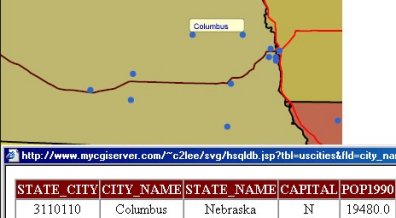
� I ran across an open source (under GPL) solution to move data from ArcView 3.x to SVG called Av2Svg Internet Mapping Toolkit. The demo is pretty nice - it has tooltips and legend support. This might be a good solution for those who don't need a complex application online. � Wired reports on Dr. Alan Zelicoff's Internet-based database application called Rapid Syndrome Validation Project, or RSVP. It's a real-time solution to finding patterns of disease. The system tags diagnoses not with a patient's name but an age range and Zip code. The combined mapping and notification program is slated for government funding, but it's on hold for now.
� Announcements The Urban and Regional Information Systems Association (URISA) is pleased to recognize individuals who were awarded the 2002 Horwood Critique Prize: Horwood Critique Prize Award Winner: Kris Kolodziej, et al., Massachusetts Institute of Technology, Cambridge, Massachusetts Honorable Mention: D.E. Temple-Smith, G.T. McDonald, C.A. McAlpine, University of Queensland, Australia Horwood Critique Student Prize Award Winner: Kris Kolodziej, et al., Massachusetts Institute of Technology, Cambridge, MA Honorable Mention Student Paper: Shilpam Pandey, Cornell University, Ithaca, New York Autodesk GIS Exposition 2002 webcased is online. The Survey of India (SoI) released its first map in digital format on WGS 84 Datum for civilian use. DNREC's Division of Soil and Water Conservation, in cooperation with the Delaware Office of State Planning Coordination, is offering grants totaling $100,000 to promote the use of conservation design for developing areas of the state and to assist in the management of open space conservation areas in residential developments. Local governments interested in conservation design and residential community groups that manage open space lands can receive competitive grants of up to $20,000. Preproposals must be submitted by Dec. 16. CIS/GIS/CRM-Maximizing Your Customer Information with Integration to GIS is the title of the latest webcast in GITA's 2002 series slated for December 3. The National Science Foundation (NSF) has awarded Visual Learning Systems a Small Business Innovative Research (SBIR) Award to study mining information from large image databases.
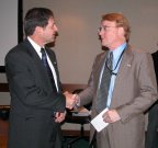
Steven Cooper, Special Assistant to the President for Homeland Security addressed the Federal Geographic Data Committee (FGDC) Steering Committee at their fall meeting in Washington D.C. His message, according to an FGDC press release: it's time to get serious about using geospatial data for homeland security. At right, Steven Cooper, Special Assistant to the President for Homeland Security, left, and Tom Weimer, Deputy Assistant Secretary for Water and Science, Department of the Interior, at the October 9 Steering Committee meeting of the FGDC. Mass High Tech announced the selection of Intergraph and Bentley's premier partner in Croatia, GeoFoto, has signed an agreement with Laser-Scan that allows it to deliver Laser-Scan's innovative Radius Topology product to its customers throughout Croatia. Marlboro, New Jersey was honored as the recipient of the 2002 John Harvey Memorial Award, presented by the Monmouth County GIS Management Office, for demonstrating excellence in the use of GIS (Geographic Information Systems). � Contracts and Sales GDS & Associates Systems Ltd. has been retained by Strathcona County, Alberta, Canada, to spatially enable their existing By-law Enforcement System using ESRI's ArcIMS technology. Sanborn announced that the company has won contracts for four mapping projects in three states including North Carolina, Georgia, and California. Sanborn's Charlotte, North Carolina office will perform the work. MacDonald, Dettwiler and Associates Ltd. announced that the National Oceanic and Atmospheric Administration (NOAA) in the United States has ordered $1.5 million (CDN) worth of information products from MDA's EarthSat subsidiary. � Products Digital Engineering Corporation/Citygate GIS Inc. introduced its ROADBlock Software, a product that aids law enforcement officials with the task of closing off roads after a crime has been committed. ROADBlock was offered at no cost to all jurisdictions involved in the Sniper Investigation. The software was implemented by the Virginia State Police, the Maryland State Police, and the District of Columbia Metropolitan Police. SpatialAce, an advanced toolkit for building interactive geographical applications from Carmenta will get plugin support for RaveGeo, a new compression and streaming technology for digital maps from Idevio. Questerra announced the release of its Internet-based visual decision support and analysis service that provides an innovative solution for minimizing risk across lines of insurance business. M.J. Harden Associates, Inc. announces the availability of the ArcGIS Pipeline Data Model, jointly developed by M.J. Harden Associates and ESRI. � Hires, Appointments and New Offices Analytical Surveys Inc. (ASI) announced plans to move its corporate headquarters to San Antonio, Texas, from Indianapolis, Indiana, effective Jan. 1, 2003. In other company news, ASI's chief financial officer, Michael Renninger, has said he will resign his position on Dec. 15, 2002, to pursue opportunities outside the GIS industry. Applied Geographics, Inc. (AGI) announced the addition of Kevin O'Brien as a GIS Analyst for the Municipal sector to the Manchester, Connecticut office. Prior to joining AGI, Mr. O'Brien was employed by the Connecticut Department of Environmental Protection (DEP) as a GIS Specialist for the Office of Long Island Sound Programs.
ADVERTISE WITH US
CONTACT
SUBSCRIBE/UNSUBSCRIBE |