Letters, Points of Interest, Week in Review, Back Issues, Advertise, Contact, Subscribe/Unsubscribe
EDITOR'S NOTE Best wishes to all our readers for the holiday season and New Year. Adena
MICROSOFT MAPPOINT .NET V. 3 MapPoint .NET is a service, an Extensible Markup Language (XML) service for developers, Lombardi is quick to point out. If you want more specific details on what that means, read the article he wrote for Directions Magazine. Bottom line: MapPoint uses XML to return the "answer" to a location-related question. That's important because XML is a standard, open way to deliver data. And, perhaps more importantly, it means developers can "tune" the answer for whatever hardware/software combination desired (desktop, WAP phone, PocketPC, Linux, etc.) This service is not for end-users. We'll use the things built from it - like say MSN CarPoint - where you can find traffic accident maps and the cheapest gas in your area. The gas application pulls maps from MapPoint .NET and gas price information from another XML service. You can get a feel how others use the service by visiting Dollar Rent-A-Car. Lombardi made it clear that the end user will probably not even be aware of MapPoint .NET. Interestingly, Microsoft puts a MapPoint .NET identifier on the maps, so that's not quite true. So, what is this service that will, in essence, be invisible to users? Basically, it's a gathering of data and services with which programmers can build applications. The data includes basemaps, cartographic ("pretty") data, and more. Services include rendering, geocoding, routing, and others. The data comes from a variety of vendors, and you can upload your own. Or, if you are a data provider, you can sign on with Microsoft to make your data available to developers. Then, if and when your data is used, you would collect a royalty. Microsoft has done one thing for U.S. users: it has licensed data from two big U.S. data providers, Geographic Data Technology (GDT) and Navigation Technologies (NavTech), and merged them into a "best" basemap. The goal was to use the better data of the two for different geographies. I asked Lombardi about how MapPoint .NET compares to the "traditional method" of creating GIS which involves buying or building software and then buying or building data and applications. Lombardi referred to that process as "a complex task." He explained that MapPoint .NET makes the process and its results "available to the masses." I'd put it this way: with MapPoint .NET you go directly to building location-oriented applications. There is no searching for data, negotiating licenses, or learning mysterious GIS software. Instead, you jump in, use standard interfaces (any platform or development environment that supports W3C standard SOAP-based XML Web services) and pay on a per transaction basis. Microsoft contends that this new way of building applications is cheaper and faster. Who's heeding the call of MapPoint .NET? Lombardi cites three groups. The first group includes traditional GIS community developers who are weighing their options of using off-the-shelf software and data versus a service to build the latest needed application. The second group includes information technology people who are looking to weave location into their business processes. The last group is what Lombardi calls "the new breed." Most come from traditional GIS, but see MapPoint .NET as new way to provide value to the end user. ESRI announced its first "packaged" service last week, ArcWeb USA. It includes, as MapPoint .NET does, both data and services.
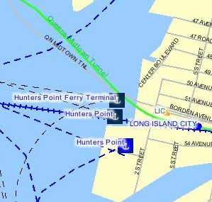
PLANGRAPHICS NYC TRANPORTATION STRIKE APPLICATION
I spoke with Mike Wiley, a Plangraphics Senior Systems Analyst, who was involved in building the application. The team used the core tools of EMOLS, which were also used in several weather related emergencies and 9/11. This time a solution was put together in less than two weeks. Wiley noted that the team had discussions about the interface and coded the application in just a few days. Mayor Bloomberg noted the application's availability on the My NYC.gov Portal page (under the "I want to�" list) during a TV spot. That sent 80,000 commuters to the site last Sunday, with peak visits between 5 pm and 8 pm. Once the strike threat was off, the site was unlinked from the city page, which is why if you tried to visit the site noted in the company's press release, it was unavailable. I was provided access and found an attractive site that pinpointed Bicycle/Pedestrian Options, Parking Options (including Park & Rides and Carpool Staging Areas), Rail Options, Water Options, and Road Restrictions.
WANTED: INNOVATIVE ORGANIZATIONS � hires non-GIS people for GIS work If your service organization (not a software or hardware vendor, sorry) falls into one of these categories, or if your organization has other unique characteristics, please drop me an e-mail with a few sentences about it. Thank you!
LETTERS � FH wrote to provide a correct URL on the story about Russian GIS industry cooperation with the Indian industry: "The link in the 12/19 GIS Monitor was not correct, here is the � Robert Cheetham wrote to comment on the groups digging up information on a known spammer, including photos of his house, much like groups have done to the new head of the U.S. Total Information Awareness project: "I saw another similar article last week on The Register about a group that got together via Slashdot to harass the self-styled Spam King outside Detroit, posting aerial's of his new house and tracking down his address using public databases. While I applaud their vigilante efforts at some level, it is also sobering to understand the ease with which people can be targeted for harassment." � Jeff Bailey, wrote from Melbourne, Australia to note his experience with a Tablet PC: "Yesterday we loaded the new ArcPad 6.0.1, which was released this week, on the HP/Compaq Tablet PC. We used the EMTAC Bluetooth GPS. We hope to also have a Bluetooth to serial adapter that will link the Leica GS5+. It was a fantastic combination of hardware and software until the client stepped out into bright sunlight. It was next to useless in sunlight. The screens on the Tablet PC units are not designed for outdoor usage!" � A reader noticed that I picked a product from Autodesk as Product of the Year and that Autodesk is a sponsor of GIS Monitor from time to time. The editor replies: The perceived connection between editorial and advertisers is a challenge for any publication that accepts advertising. I write about what I think is important, praise notable products/services/trends, and note those in need of improvement. Advertisers provide the funds for that to happen, but do not direct content. I stand by my choice. � Bill Huber raises some other points about GIS and homeland security: "I would like to raise a concern that I have not seen addressed or even seriously voiced in the GIS community. Part of a GIS application for E-911 or Homeland Security involves accurate, rapid response in emergent situations. The consequences of mistakes can be fatal or catastrophic. "How, then, are we to assure these systems will perform adequately? Certainly the systems integrators and high-end developers will need to take special care in their work. Ultimately, though, the reliability and safety of these applications rests fundamentally on the reliability of the underlying GIS software. ". . . My experience is that these [GIS] platforms are deeply and pervasively riddled with bugs. For example, one popular GIS product still ships with extensive debugging code ('Assertion errors') more than seven years after its first release! "The consequences of not taking these steps are obvious, and dire in the case of Homeland Security and E-911 applications, so I am baffled at how the industry's major vendor so blithely and systematically ignores them. Maybe the obvious does need to be spelled out: "Unless users are encouraged to identify and report bugs, the vendor itself will identify them only slowly. The user and developer community must be engaged in, and rewarded by, the activity of improving the software's reliability. "When bugs are not prominently published in a public place, (a) users spend countless hours suffering from, identifying, and working around problems that should have been made known to them; (b) applications may fail, perhaps with critical consequences, when otherwise their implementers would have had sufficient prior warning to forestall the failure. "If bugs are not fixed, but left to persist in revision after revision of the software, then the apparent usefulness of bug identification and reporting is nil. Moreover, users may be led into believing that software upgrades have fixed previous problems, when in fact they have not. "I do not know how clear the law is on these points, but it is only common sense that if a critical GIS application fails, with material negative consequences, and the failure is traced to a bug that was reported, kept secret, and not fixed, then the standard EULA is not going to be sufficient defense against a charge of willful negligence on the part of the GIS software vendor. "Thus, there appears to be sufficient incentive on the part of conscientious users, systems integrators, and GIS software vendors to improve the process of bug identification, reporting, and fixing. Why, then, does this community appear to be so complacent and tolerant of buggy software? That is the mystery. As a community we need to open this issue, discuss it, and get it resolved, somehow, before we are nailed by a catastrophic failure. It would be very interesting to hear from other readers what their attitude is on this issue and to what extent their organizations are addressing it, if at all."
POINTS OF INTEREST � The state of E-911 in Indiana. Indiana is one of the states leading the way in implementing wireless phone location technology for emergency services. The score: In Vigo county, three of the six carriers offer Phase II support (ideally to be provided nationwide by year's end). 34 of 92 counties in the state now have the Phase II capability from at least one carrier. � Autodesk has made the handouts from Autodesk University available to everyone, even those who did not attend. The handouts for each class can be downloaded individually in PDF. The handouts for an entire track are also available in a Zip file. The GIS handouts total 17.4 Mb. Some the documents are PDFs of PowerPoint slides (less useful) while others are actual papers (more useful). � This week Microsoft released DirectX 9.0, "a group of technologies designed to make Windows-based computers an ideal platform for running and displaying applications rich in multimedia elements such as full-color graphics, video, 3D animation, and rich audio." This technology is becoming important for GIS and visualization software, in addition to games. � A "smart mob" is a group of people who are mobilized by text messages and other new communications technologies. Young women share information on the whereabouts of Prince Andrew, who is often, not so inexplicably, mobbed by them. Protesters used mobile phones, and other devices in Seattle to organize against the World Trade Organization. The response to the Miss World competition in Nigeria also had smart mob elements. The person who coined the term, Howard Rheingold, in a book of the same name, feels that the new communications will redefine our definition of community, in particular away from geography-based communities. I heard about this on National Public Radio's On the Media but it's covered elsewhere. � If you like to see things before everyone else, check out this article with pictures of the new Garmin handheld with built-in GPS. It purportedly runs PalmOS and has an elegant color screen. The iQue has already won awards, but is not due to be unveiled until the Consumer Electronics Show next month. � Stephen Lawson, writing in InfoWorld, comments that GPS devices "on the ground or in the air send signals to a network of satellites." GPS is getting a bad rap with all of its use in tracking technologies. GPS is a passive technology it listens for signals from satellites. Only in some new phones and some radios, does it send out information on its location. And, in most you can configure when the signal can be sent. After an e-mail from me (and perhaps others) Mr. Lawson posted this correction: "Correction: In this article, how GPS (Global Positioning System) works was originally misreported." � Need a laugh as we head into the holidays? Check out this article on some of the more hilarious requests of British tourism officials. My favorite, with particular thoughts of one my geography professors, Wilbur Zelinsky, "Would you show me on the map exactly where the Scottish accent stops and the English accent starts?" � Jon Oltsik, writing for CNET, listed his top ten overhyped technologies and marketing messages this year. Number one? Return on investment (ROI). A telling story: an IT manager wanted to buy a new product because he argued it would save the company $75,000. The CIO was happy to make the purchase, so long as the manager dropped $75,000 from his IT budget. The manager, as you might expect, said no. � No Christmas bonuses at MapInfo, ever. According to an article in The Record (Troy, New York), MapInfo will not give out bonuses at the holidays this year, keeping a longheld tradition alive. "Historically, MapInfo has not given holiday bonuses. ... It's just simply never been part of our culture. ... Like many other companies, our bonuses are based on performance," said company spokesperson Angela Girard.
� Announcements ESRI Virtual Campus presents Learning ArcGIS Spatial Analyst, a new course designed for experienced ArcGIS software users who want to learn how to create, modify, and analyze raster surfaces using ArcGIS Spatial Analyst. KOREM announced a partnership with Empower Geographics. This new agreement enables Empower Geographics to resell Push'n'See, KOREM's GEObroadcasting Web software. Leica Geosystems announced an Imagery Workshop, a free one-day hands-on event at the Palo Alto Marriot Courtyard from 9:00 am - 4:00 pm on Thursday, January 23, 2002, or Friday, January 24. Call: 303-221-5720 or 1-877-318-0420. The Huntsville Times reports that Intergraph is in a good position going into lawsuits against three computer makers. A lawyer suggests that careful notification by Intel to its clients that the company provided no immunity from lawsuits is key to the case. A lawyer familiar with past Intergraph suits says the previous wins will have an impact, "You're talking about exactly the same chip, so you're probably going to have the same results." The Open GIS Consortium announced a Request for Comment (RFC) on its Web Coverage Service (WCS) Implementation Specification. The RFC details draft interfaces that allow gridded and certain non-gridded geospatial data on a server to be accessed and used by client software as input into spatial model, local rendering, and other uses. Comments are invited from any interested parties for 30 days, until Jan. 17, 2003. The U.S. Census Bureau and Northwestern University will formally open a research data center (RDC) laboratory Thursday, Dec. 19, in Chicago, the eighth such center in the country. Thales Navigation has donated Magellan GPS receivers and software as part of its partnership with the Federation of Galaxy Explorers, a national non-profit organization that furthers children's education in space-related science and engineering, both inside and outside the classroom. Earth Resource Mapping announced a strategic partnership with AgroGIS, Brazil. AgroGIS provides GIS solutions and data consultancy in the Agricultural Market in southern Brazil. AgroGIS intends to offer ER Mapper as part of its integrated GIS management solutions package. The San Bernardino County Sun reports that ESRI is expanding its campus in Redlands. The new three-story building may mean some upcoming street closures. Analytical Surveys, Inc. reported fourth quarter revenues of $4.2 million versus $6.6 million in the same period a year ago. The Company reported a fourth quarter net loss available to common shareholders of $1.2 million, or $1.52 per diluted share, versus a net loss of $5.6 million, or $7.95 per diluted share, in the fourth quarter last year. Safe Software demonstrated its FME at the Hanley-Wood has purchased A/E/C Systems International from Penton Media, Inc. A/E/C Systems produces two trade shows serving the architectural, engineering, and construction industries. Webraska toned down its claim of "compliance" with proposed OpenLS specifications in a newly issue press release about its SmartZone Geospatial Platform 3.0. The original can be found here. The FGDC working group on Geospatial Applications and Interoperability has released a draft Geospatial Interoperability Reference Model (GIRM) for public review and comment. The goal of the document is to "help decision makers choose standards to facilitate interoperable geoprocessing." � Contracts and Sales Applied Geographics, Inc. (AGI) is implementing a Geographic Information System for the Town of Hebron, Connecticut. American Outland chose ECW to distribute their Landsat TM sensor data for a variety of geographical locations around the world with the authorization of The Earth Satellite Corporation and NASA. � Products Z/I Imaging Corporation, an Intergraph wholly-owned subsidiary, announced today the release of I/RAS C Version 8.4 featuring compatibility with Bentley Systems' MicroStation Version 8 CAD platform. I/RAS C provides high performance imaging capabilities for the vector-based MicroStation product geared specifically for mapping, GIS and photogrammetry users. Leica Geosystems has released ERDAS IMAGINE V8.6, a geographic imaging software suite. The latest version of ERDAS IMAGINE features a hyperspectral image analysis enhancement; common vector data access between ERDAS IMAGINE and ESRI ArcGIS' Geodatabase formats; and makes the IMAGINE Geospatial Light Table (GLT) a standard interface. Kivera launched the newest version of its Kivera Location Engine, providing significantly enhanced performance and reliability to developers of LBS applications. Luciad announced Version 3.0 of its flagship product LuciadMap, scheduled to be released next month. LuciadMap is a Java software toolkit to visualize, distribute, and transform geographical data in networked environments. Positioning Resources Ltd. announced the introduction of Bluetooth GPS as an option with its PocketGIS Field Data Capture Software. Bluetooth is a short-range, low-power wireless communications technology that has been created as a replacement for the cables that connect mobile systems together. � Hires and Appointments CompassCom Inc. has expanded its sales management team to better manage the growing need for asset tracking technology created by the expanding Public Safety and Homeland Security markets. Christian Solomine has been promoted to the position of National Sales Manager. Also promoted from within is David Bry, who is assuming the new role of Central Regional Sales Manager in addition to maintaining his duties as GIS Products Manager. CompassCom has also hired Arthur Femister for the position of Western Regional Sales Manager. PCI Geomatics hired David Ross to manage Eastern United States sales territory. Daniel Karnes, Research Assistant Professor of Geography, recently was appointed as GIS Curricular Consultant at Dartmouth College. The half time, three-year appointment will enable Karnes to promote and facilitate the use of GIS in the classroom. Karnes uses the title "GIS evangelist."
ADVERTISE WITH US
CONTACT
SUBSCRIBE/UNSUBSCRIBE |