Letters, Points of Interest, Week in Review (Announcements, Contracts, Products, Events, Hires) Back Issues, Advertise, Contact, Subscribe/Unsubscribe If, for some reason you cannot read this document, visit: http://www.gismonitor.com/news/newsletter/archive/101603.php
EDITOR'S NOTE As I've noted in the past, (there are articles by others here) I have mixed feelings about certification. Part of the reason for my ambivalence may stem from the fact that I have not personally encountered a situation in which I was held back professionally because GIS was not considered "a profession." I know of other people, however, who have. They make a good point that URISA's work may ensure that no one else runs into that type of discrimination again. On the other hand, it's hard to know if the perception of "GIS as a second-class profession" might have, in time, disappeared on its own. It's too late to worry about such things. GIS certification is here. URISA made it happen after discussions that I understand date back thirty years. There are still issues to be worked out in the process and URISA hopes to draw in other professional organizations to support its work and vision. The existence of the new monicker GISP and the process behind it will no doubt change the GIS community - its schools, training classes, conferences, books, magazines and other tools of the trade. And, there will be change, too, in the people of our community. Exactly what those changes will be is unclear, but I promise to keep an eye open for them as the next batch of potential GIS Professionals (GISPs) readies their application materials.

INTERVIEW: STEVE KINZY ON URISA YESTERDAY AND TODAY You are joining the URISA Board of Directors this year. If I recall correctly you'd been active in URISA in years past. What's your thinking in becoming active again? I have been an active URISA member since 1972 at the encouragement of Dorothy Bomberger, Ken Dueker, Bob Aangeenbrug and others. I served on the URISA Board for the first time from 1978-1982. I've always thought of URISA as the professional home for folks that think of themselves as "GIS Professionals" first and planners, engineers, computer analyst, foresters, etc., second. With the launch of the GIS Certification Institute this year, I thought it was a perfect time to get actively involved in helping promote the importance of certification to the GIS professional community. URISA has always been a multi-discipline inclusive organization for those of us who are passionate about the ethical use of spatial information and information technologies for the understanding and management of urban and regional systems. Has the role of URISA changed over the years? What should be its top priority heading into 2004? When I was on the board for the first time in the 1970's, we were a very small organization of about a thousand members. We were searching for ways to adapt information technology for practical application in our city, county, state and federal agencies. While I don't think that goal has changed much since then, I think we have more than proven the value of the technology with thousands of successful applications transferred into public sector organizations worldwide. The major problem in the 1970's, as it is today, is that we don't have nearly enough trained and experienced GIS professionals to meet the demand. Public sector organizations also need to recognize the value of hiring and retaining dedicated GIS professionals to guide the development of enterprise GIS technology. URISA has always focused on providing a forum for GIS education and professional dialog. That should continue to be our single most important priority. A few years ago (when I was an ESRI employee) I commented to you that user presentations at conferences seemed like "old news" to me. Your reply was that the vendor community was, at that point, far out in front of the users. Is that still as true today? Is the gap closing? For the most part, GIS innovation is happing in the private sector today, thanks to a variety of very successful companies that are spending millions of dollars to continue to develop products and services designed to integrate GIS technology into dozens of mission critical applications for land records management, infrastructure management and emergency response, just to mention a few. When I first got into GIS in 1971 with the GBF/DIME program, primary innovation was happening in the universities and in the federal government with URISA being a means of disseminating that technology. Today, the private sector is doing an extraordinary job in getting the message out about new technology and the importance of GIS implementation. URISA's function has changed and the organization is now concentrating on basic education, policy issues and implementation strategies. It's not really "old news," it's just "different news" as there are many more channels that are being used to get the word out. ESRI, and you personally, attend quite a number of GIS and other conferences and trade shows. How has their role changed over the years? Do vendors and attendees expect to take away different "things" than they did in the past? As I indicated above, the private sector is now responsible for communicating most of the information regarding technology at their user conferences and marketing events. Multitudes of state and regional GIS conferences are now responsible for establishing a basic network for local GIS communication. URISA has settled into the roll of providing national and international communication among GIS professionals. While vendors don't do a lot of direct sales at a URISA conference anymore, you can never be taken seriously by the GIS community unless you are at the [URISA] conference. It's the place where you establish your professional credentials. [Attending URISA and other professional conferences does indeed provide points for certification. -Ed.] What do you expect the landscape of conferences to look like in five years? Is it time to change the "model"? I think the model has changed. Vendors are providing basic technology at their events, and state and regional conferences are providing opportunities for local GIS communication and the promotion of state and regional programs. Conferences like URISA now provide a very comfortable home for GIS professionals to network and learn from each other. Where else can you go every year and have an opportunity to talk with the founders of GIS technology in a small and very comfortable setting? Last year at our forty-year anniversary conference we had over twenty URISA past presidents in attendance. What a tradition! Ed Horwood [URISA's founder] would have been very proud.

The details on certification, as they stand, can be found at the GIS Certification Institute, the organization that runs the certification program. Look for more on certification in next week's issue.

In his keynote, Michael Shiffer, VP of Development for the Chicago Transit Authority, discussed public participation in transportation issues, visualization, and some important measures of public transportation use: tracking how much different parts of the network are used, as well as how use changes with increases in fares.

This session had actually grown out of a round table discussion at a previous URISA conference. In fact, one of the speakers suggested this topic might make a good focused conference down the road. Steve Grise of ESRI opened a session on data modeling. Before it started I expressed to him my belief that data models are perceived as complex and intimidating, perhaps akin to some GIS users irrational fear of metadata. He made a good point: you can have a GIS without metadata (though you probably would not want to) but you can't have a GIS without a data model. This suggests that we all probably know more about data models than we realize, since we work with them every day. Grise began his formal presentation by noting that while towns in different geographies are different, they are not unique. By that he suggested that starting with a data model, one created by some kind of consensus, is a good idea. He noted that the Province of Ontario set up its model 20 years ago and it has not changed much since. The most common data modeling that seems to be going on now involves moving data from files (shapefile, CAD, etc.) into a database. A good data model is key, but "design compromises," (organizational decisions made to work with that data format or software), need to be left behind when moving into the new system. Several of the presentations I attended were elementary, with some content clearly designed for the GIS newbies in the group. One began with the definition of a GIS, and examples of how it is used. Another detailed how GPS works. One other session gave me pause: it was essentially a twenty-minute advertisement for a particular vendor's product.

I arrived on Monday in time to catch the second half of the "round table discussion" luncheon. Fifty-five topics were displayed on corresponding round tables. I didn't look at the list, but simply sat down at the most animated table. It was one of the three tables assigned "GIS Professional Certification." (My thanks to my table-mates for filling me in on the opening session and certification.) On Tuesday I chose to attend the GeoSpatial One-Stop (GOS) lunch seminar hosted by Hank Garie (GOS executive director) and Jack Dangermond (ESRI president; ESRI developed the current iteration of the portal). Garie reiterated remarks made at the National States Geographic Information Council meeting last month highlighting a need for a new vision for national mapping. When asked essentially, "Why should local government get involved? What's in it for them?" Garie replied with ideas of visibility. State and agency GIS practitioners that participated in a "channel [a set of data and services specific to that event] for Hurricane Isabel" at GeoData.gov were able to show their bosses how they helped, and how what they do matters locally, regionally, and nationally. Participating in GOS, even during non-emergency periods, is a way for local governments to gain similar positive attention. One attendee noted that "peer pressure" worked particularly well in getting NCOneMap (the seamless statewide digital map of North Carolina) together. Other commenters noted that stronger federal leadership might be needed to ensure local involvement and that recent small grant programs are not enough to make a significant difference. A county GIS manager noted that, while GOS had some local organizations (International City Managers Association and National League of Cities) on its board of directors, there needed to be more input from active local governments. Jack Dangermond explained that the GeoData.gov portal is really just a Web-accessible card catalog of spatial data and services. He noted that some 25-30,000 websites provide spatial data or services. He called attention to the fact that participating in the portal did not involve "giving up data," but rather involves providing a few metadata records. The data/services continue to live and operate as they do now. He also highlighted the plans to harvest metadata from FGDC clearinghouse nodes, which should not require any significant work on the part of those organizations whose data offerings are currently listed there. He noted that the portal is built to support the Open Archive Initiative Protocol for Metadata Harvesting, a generic protocol for gathering metadata. That was the first I'd heard of the protocol. Dangermond stressed that participation in the GeoData.gov portal is open to all - to both public and private sector data creators. A question about equity for commercial players brought up a suggestion of a rating system similar to the one Amazon.com uses for books, CDs, and other products. Garie and Dangermond both stressed that the idea that the portal's data viewer allows data from many servers to be merged together and used in new ways. Much of what's exciting about the portal and other such systems is the implementation of basic geospatial interoperability. The tools to do that existed before GeoData.gov was launched and are available in the marketplace today. On Wednesday I attended a session on new technologies for geospatial database acquisition. This was the low-down on the new aerial techniques including the use of LiDAR and digital cameras.

Unfortunately, the exhibit hall was in the basement of the hotel. It had low ceilings and lighting was less than optimal. According to the program, there were 53 exhibitors, including three schools and four magazine/newsletter publishers.

• In 1995, all Day One maps that were used to respond to the bombing were on paper. On Day Two, they began to find and use building design information. In time there were 3D renderings. • According to authorities' predictions, future terrorist attacks may be more along the scale of the OKC truck bombing rather than the magnitude of the World Trade Center attacks. • Maps were provided to the press and also to the family centers in OKC. Family members of the victims appreciated knowing what was happening. • Hansen finished with two thoughts: that we need to share data, and that Autodesk's technology is very user friendly. So friendly in fact, that someone like him, a non-technologist, could immediately use it. I couldn't help but think, after recently seeing former Wyoming Governor Geringer speak about GIS, and MapInfo's planned (but to my knowledge not executed) town meeting with Hillary Clinton, that the idea of "celebrity" spokespeople may be coming into vogue to spread the word about GIS.

• At least one unfortunate presenter had the uncomfortable experience of the projector not syncing with his laptop. At the session I attended there was good news: he had a backup of the presentation on CD, which ran flawlessly on a borrowed laptop. Let's hear it for careful planning! • Prepaid lunches (boxed, at $30) were available for Tuesday's and Wednesday's luncheon seminars. You could bring your own lunch, too. I saw a number of bags from the local food court as well as home-made peanut butter sandwiches. • I understand that a session, which was to include Jack Dangermond and another speaker who did not appear, left Dangermond with a full 90-minute session to himself. • How big was the URISA conference? The number provided to me by the organization was about 800, including vendors and exhibits-only badges. Other numbers suggested to me, based on unscientific study, averaged around 500 registered attendees.
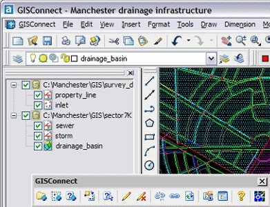
A NEW CAD/GIS SOLUTION
Conceptually, that's exactly what happens. The interface in AutoCAD, a toolbar and companion pull-down menu, makes calls to ArcGIS (via ArcObjects, the developer objects that are inside) and tells ArcGIS what to do. For example, via GISConnect an AutoCAD user can pull in geodatabase data into AutoCAD, edit it (both geometry and attributes), and save the changes back to the geodatabase. The way this works, as I understand it, parallels many of the other products in this space including ArcCAD (no longer available), SDE CAD Client and even Autodesk Map. The similarity boils down to the fact that in order to see and actually work on entities in AutoCAD, they must be rendered into a drawing. That essentially means creating a "duplicate" version of a feature from a geodatabase (in the case of GISConnect) or an element from a source drawing or database (in the case of Autodesk Map or SDE CAD Client respectively). But fear not! That "duplicate" that appears on the screen is indeed linked to its source. This means that when changes are made, and then committed, everything is in sync. The folks at Haestad note that their solution is far more elegant than those that have come before. And, as someone who worked on several other products in this space, I'd have to agree. There are a handful of tools to query and access ArcGIS data that have elegant AutoCAD-like dialogs. Once the selected features are rendered in the drawing, the user is free to use any and all AutoCAD tools. As I watched one demo, Scott Devoe, Director of Strategic Development and the lead programmer, redefined how points were displayed using an AutoCAD block. He then pulled geodatabase attributes into AutoCAD attributes and edited them with the "ddatte" command. Finally, he edited geometry with the AutoCAD entity's grips. All of these changes are held in an edit cache until the changes are committed to the geodatabase or "thrown away." What makes this particular live connection more interesting than those that came before is the fact that ArcGIS "rules" are obeyed. If attributes are restricted in ArcGIS to 6-inch or 8-inch or 10-inch pipes, only those attributes will be available in AutoCAD. If there is an attempt to "break" a geometry rule during editing, a message immediately warns that the edit cannot be made. While AutoCAD retains all the power of its editing tools, the editing process is 100% ArcGIS-based. When data is brought over into AutoCAD via GISConnect, feature classes are mapped to individual layers. By default, all layers are locked to editing. To edit a layer, the user selects the "start-editing tool" and is asked to select a layer of interest, which is then unlocked. When editing is complete, the changes are committed or thrown out. ArcGIS users will recognize that process as exactly parallel to their workflow. Unfortunately, like in other products, a savvy (or malicious) user can bypass the process and wreak havoc. This first release has some limitations. Only points, lines, and polygons are supported. Annotation will be included in the next version, which thrills Devoe since he looks forward to tapping into ArcGIS' label placement tools. Moving raw AutoCAD data into a geodatabase (the reverse of the discussions above) requires using ArcCatalog to set up an "empty" schema, into which it will be loaded. For now, there is no versioning support so that multiple users can't edit the same area and resolve changes, but that's in the works. Haestad is also exploring how GISConnect might one day work with ESRI's newly announced ArcEngine. The product was born of necessity. Haestad began development on some tools to help a consulting firm aid a client, a municipality, move its AutoCAD-based sewer network into a GIS. In time it became clear there was a significant demand for a tool that would let longtime AutoCAD users interact with GIS data in their own environment. Enter GISConnect for AutoCAD. Will GISConnect revolutionize CAD/GIS integration? I feel confident it will be exactly the right solution for some. And, it certainly builds on work that went before and takes advantage of the fine development environments of both AutoCAD and ArcGIS. Has it made using the two technologies together seamless? No. Is it on the right track? Most definitely.
"Just had to tell you this issue was full of very interesting information and one of the best issues. Good job!" The editor replies: Another reader felt that last week's issue, and others, had too much coverage of the "E" company. You win some, you lose some. • A reader recently happened upon the Degree Confluence Project. GIS Monitor covered that project in 2001, but as he notes, "it's a neat idea and a work of art..." • Several readers clicked on a link in last week's Points of Interest section to find the article by Peter Manos, and found an error message. The link acted fine that morning, but a malfunction at the website yielded a "404 error" after publication. I forwarded a note to the webmaster and soon after, the problem was fixed. If you didn't get chance to check out the article, try again. • GIS Monitor's official Mac advocate, Gary Quinton, has additional info on "switching from Microsoft." "In regards to your article on monopolistic Operating Systems and the potential for catastrophic security breaches. This is not new news (though you never said it was). The U.S. Army switched some of its Web servers to Macs several years ago in response to Hackers attacking the Swiss cheese that Microsoft calls 'security'. That was of course 1999 before the introduction of the more robust Unix based Mac OSX and the new Mac X-Server which is gaining popularity for the very reasons sighted in your article." The editor replies: More on that front crossed my desk this week. Two-thirds of respondents to an Internet Week Reader Question said they are dissatisfied with Microsoft software. Just 28% said they were satisfied with Microsoft software. The details are interesting, as are the comments.
POINTS OF INTEREST Just a Second. Reader Atanas pointed me to a report explaining that several Motorola GPS receivers in its Oncore line will misdisplay the date on Nov 28, 2003 at midnight UTC. For a one-second window the date will be a day ahead. Deep down it has to do with a lack of leap seconds since 1999. I don't exactly follow what's going on, but I really liked the title of the post: "The Earth's not slowing down fast enough to suit Motorola." New Aircraft for Remote Sensing. Brigham Young engineering students and researchers, under a military contract, are designing and testing new remote sensing remote control airplanes. These have onboard stabilizers and obey voice commands. The also carry video equipment. The 100-gram planes have a 24-inch wingspan and are launched, at least in the graphic accompanying the article, like those balsa wood gliders for kids. If you want a cheap, stable, relatively non-moving platform for remote sensing, try a kite. Locating is for Kids. MobileLocate's new service, ChildLocate, can locate a mobile phone (Vodafone, O2, T-Mobile and Orange) anywhere in the UK. The service costs EUR 14.10 (£9.99) per month per family, which includes a monthly allowance of 10 location requests and 10 short text messages. The ChildLocate service is accessible via the Internet or with the use of text messaging on your mobile phone. Accuracy? The company notes a range of "50-500 meters in urban areas but less in rural areas." The discussion never suggests that one might want to locate an adult's phone, perhaps to avoid some privacy issues. Not far from where I live in Boston, uLocate is introducing a similar service. The company is offering three months of free service as part of its national launch. Mapping for this solution is from MapQuest. Two Headed Monster Indeed! If you were one of the lucky ones to run a two-monitor configuration of MicroStation, you had a leg up. A recent study by NEC-Mitsubishi Electronics Display of America, Inc., ATI Technologies and the University of Utah found that multiple monitors do indeed enhance productivity. Space Technology for the Developing World. The President of the Long Island Space Society recently attended a small day-long meeting at the United Nations on the role of space technology in the developing world. It was co-sponsored by Space Equity and the National Space Society. This person has a nice write-up about how the conference touched on GPS, especially for precision agriculture, the use of remote sensing for conservation, and the challenge of lowering launch costs. Ag Prices in India. Starting in December, customers in West Bengal will be able to check out the prices of agricultural commodities across the state on the website of the state consumer affairs department. The website will provide the weekly price at 5,000 markets spread over 17 districts of the state. The impetus for the system: protecting consumers and supporting investors. According to the principal secretary of state consumer affairs department "With multinationals keen on investing in the food processing sector, it is imperative to provide them with authentic data." Celebrity GIS Employee. The Associated Press has a story detailing former Wyoming governor Jim Geringer's trail to his new job at ESRI. In the story we learn: - He originally turned down ESRI's offer, which would have required him to live in Redlands, California. ESRI pursued him and removed that requirement. Density Data for the Atlas. Oak Ridge National Laboratory's (ORNL) population density data will appear in the next edition of Goode's World Atlas. The data is based on the Lab's LandScan technology, originally developed for the U.S. Department of Defense. The data is so detailed it will need to be generalized for the maps. ORNL has data sharing arrangements with the National Imagery and Mapping Agency and the U.S. Bureau of Census. I suppose it's not surprising that the data has been of interest for homeland security purposes. Networked Car in You Future? The Economist takes a look at the obstacles to today's vehicles becoming full service "networked cars." There are several required: cars will need a built-in wireless system, those providing the data will require cheaper downloading kiosks, and there will have to be a realistic business model. LiDAR Illustrates Coastal Change. Scientists studying Hurricane Isabelle are tapping into LiDAR data to explore changes in the coast. The suggestion is that in time the exploration may give way to models that predict which barrier islands are most likely to be breached in a storm. Have Passive Radar, Will Track. It turns out that cell phone towers can track just about anything that reflects its signals. Using passive radar, (i.e., radar where signals leave the towers but are collected elsewhere), nearly anything can be tracked. Moreover, the system is inexpensive compared to other tracking technologies and invisible to anti-radar weapons according to an article in BusinessWeek. ESRI Education Books Winner. Two weeks ago I offered to send my review copies of ESRI Press' Community Geography: GIS in Action to a reader who indicated how they might be used in their area. Amir Toister, who is currently working on a project for the Ministry of Education in Israel, will be receiving the book and teacher's guide. Quote of the Week. "When all you do is designate critical habitat, that's just lines on a map - all that does is create uncertainty." Chuck Burley of Bend, Oregon, who is a representative of a Portland-based timber industry group, commenting on the "old" way of designating critical habitats by the U.S. Fish and Wildlife Service.
WEEK IN REVIEW
MapFrame Corporation announced that it has been named one of the fastest growing private companies (#309) in the country by Inc. Magazine. The Federal Geographic Data Committee (FGDC) announced the award of the 2003 Cooperative Agreements Program (CAP). Approximately $1,076,000 has been awarded to 51 organizations in 29 states. This year's awards provide funding for metadata implementation, training and outreach; clearinghouse integration with OpenGIS Services; and Canadian/U.S. Spatial Data Development. The City of White Rock, British Columbia was presented with an Award of Excellence (AOE) at ESRI Canada's annual Regional User Conference in Vancouver. Alex Miller, President of ESRI Canada, presented the award in recognition of the city's innovative application of Internet mapping technology for their Property Managementapplication. • Contracts and Sales CSEPP is a federally funded initiative to assist state and local governments prepare for and respond to emergency events involving aging chemical weapons that are stored at the Blue Grass Army Depot until they are destroyed. Meceola Central Dispatch, an agency serving the emergency response needs of Osceola and Mecosta Counties, Michigan chose Digital Data Technologies, Inc. (DDTI) to provide an intelligent base map and software for E9-1-1. Leica Geosystems GIS & Mapping, LLC announced that the Laris Center (Moscow, Russia) purchased two Leica ADS40 Airborne Digital Sensors for VISKHAGI, Russia's cadastre research institute. The ADS40s will be used for the Land Registration Implementation Support (LARIS) project, mainly to obtain digital imagery of cities and rural areas and for orthophoto map production. The GIS and Mapping group at Papa John's International, headquartered in Louisville, KY, responsible for generating maps used by Papa John's restaurants for delivery and routing purposes, has implemented a new map production system based around MapText, Inc.'s Label-EZ and Label-Edit software. PlanGraphics has been providing information technology planning and support services to the New York City Department of Health and Mental Hygiene (DOHMH) to support its environmental public health tracking program (EPHT) initiative. Navigation Technologies announced that NAVTECH Maps are powering the new HP iPAQ Navigation System. • Products ESRI has released MapShop for Media version 3. MapShop for Media is an online tool for media professionals without GIS experience. MapShop allows users with a Web browser, whether on a Macintosh or PC, to quickly create "news maps customized to an organization's style." Skyline Software Systems announced the release of TerraExplorer Pro, GIS Edition, v.4.5. This new version of the TerraExplorer Pro marks major improvements in capabilities for working with urban environments and stronger GIS functionality. RSI announced that it has integrated ENVI with Sensor's RemoteView software, which is used extensively by military and national defense analysts. Autodesk, Inc. with funding from GeoConnections, a Canadian partnership initiative led by Natural Resources Canada building the Canadian Geospatial Data Infrastructure (CGDI), had its Professional Services Group develop functionality in Autodesk MapGuide software to supportwith Open GIS Consortium (OGC) Web Map Service (WMS) specifications. Xybernaut Corporation and Visual Link Internet announced a computing and communications network that combines mobile/wearable computing technologies and wireless broadband communications. Japan's KDDI will offer a new pedestrian-oriented navigation service in late October along with several new handsets. The new service, called "EZ Navi Walk," uses GPS to locate and route walkers. ESRI-UK launced MapsDirect for Business. The service provides access to the latest, detailed national Ordnance Survey MasterMap digital mapping, for both high quality printing and downloading. The service has been set up to provide users with simple pay-per-view access, without plug-ins. The initial release provides 1, 4, and 16 hectare site-centred plots of OS MasterMap - the new high quality large scale mapping covering England, Scotland and Wales. Users can choose map locations by address, postcode, grid reference, map sheet or through the map interface, pay the plot fee and download the map. • Events The NEGIS Call for Presentations has gone out. The deadline is October 31, 2003 and submissions are only accepted online. The New England GIS Conference Sponsored by the New England Chapters of ACSM, GITA and URISA will be held May 12 & 13, 2004 at the Holiday Inn, Boxborough, Massachusetts. Jack Dangermond will deliver the keynote at the Novalis User Conference November 3-7 in Hilton Head, South Carolina. • Hires and Appointments LizardTech Inc. a developer of digital imaging software and viewing tools, announced the appointment of Brian Soliday as vice president of geospatial sales for the Americas. Soliday's been at RMSI, Autodesk, Space Imaging and Trimble. John Copple has been appointed CEO of Sanborn. He'll be located in Colorado Springs, where the company recently moved its headquarters. Copple left his position as CEO of Space Imaging earlier this year.
GIS MONITOR BACK ISSUES
ADVERTISE WITH US
CONTACT
SUBSCRIBE/UNSUBSCRIBE |