|
|
| |
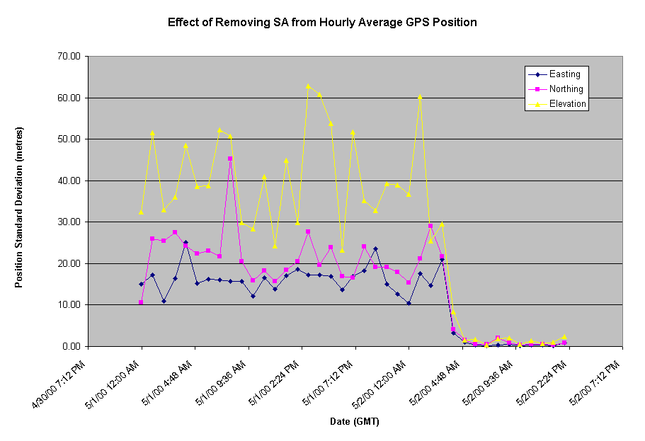
TopTen Events for 2000Adena Schutzberg 1. Best News for Data Capture: Selective Availability Turned Off (May 1, 2000) This virtually invisible flip of a switch instantly made GPS generated location information ten times better for civilian users. Selective availability (SA) had been in use to protect the security interests for the United States and its allies by adding positional "error" to all readings. As Dr. Dennis G. Milbert of National Oceanic & Atmospheric Administration (NOAA) puts it: "With SA activated, you really only know if you are on the field or in the stands at that football stadium; with SA switched off, you know which yard marker you are standing on." SA was implemented in 1990 and had been "on" all the time except for a period during the Gulf War. Two factors allowed the end of SA. First, the government's commitment to develop technology to disallow GPS use in selected geographies. This new technology will allow scrambling of locational information in areas of concern in the world, while other areas continue to use it at higher accuracies. Second, civilian companies had already discovered clever ways to effectively sidestep SA. The removal of SA means that even the most inexpensive recreational GPS receiver costing as little as $100 can now be accurate to within 15 feet, making it good enough for hiking, mountain biking and geocaching. Removal of GPS Selective Availability (NOAA) http://www.ngs.noaa.gov/FGCS/info/sans_SA/ Plot of hourly standard deviation in positions before and after removal of SA (from Portland State University) http://gps.geol.pdx.edu/RemoveSA/image001.gif 2. Best News for Elevation Data: The Shuttle Radar Topography Mission (Feb. 11, 2000) The eleven-day mission aboard the Shuttle Endeavour, begun on Feb 11, 2000, mapped the earth using radar to produce the most detailed 3D data ever. It's about 30x better than anything we had previously. From 145 miles up, the mission covered most of the inhabited parts of the planet from 60 N lat to 56 S lat. The two antennae captured data during a single pass; scientists on the ground continue to combine them via interferometry to produce DEMs (digital elevation models). Part of the allure of this new data set is that it is nearly universal - covering most of the earth, with the same equipment and in one time span. Previously, geographers had to contend with elevation data with local "flavors," making the combination of different data sets difficult. The mission was a collaboration of NASA, NIMA (National Imaging and Mapping Agency), the German Aerospace Center (Deutsches Zentrum fur Luft-und Raumfart) and the Italian Space Agency. Most of the data, except some detailed and raw imagery outside the US, will be unclassified. There were a few glitches in calibrating the data, but Jet Propulsion Lab reports that they expect to make the first sample digital topography data available in early 2001. Shuttle Radar Topography Mission Updates (Spatial News) http://spatialnews.geocomm.com/features/shuttle/ Jet Propulsion Labs's SRTM Page SRTM Mission Completed (GeoInformatics) http://www.geoinformatics.com/issueonline/issue_4/art1_4.pdf 3. Best GIS Magazine: Professional Surveyor With most of the GIS and GIS-related hard copy magazines reporting on less with each issue, there is still one that stands out above the others: Professional Surveyor. PS tops my list for a few reasons. First, the editors have jumped into the "no man's land" where surveying and GIS meet to define the roles each type of practitioner may play. PS has introduced the techniques of GIS to a traditionally CAD focused discipline and at the same time, provided GIS users a valuable look into the world of surveying. Second, a respect for the past and the law are nicely served from within the historical discussions and stories of surveyors' first adventures. The column on surveying and the law, Legal Notes, offers a fascinating look at a topic from which most GIS users would ordinarily shy away. Third, I applaud PS for regularly updating their web site with the full content of the past month's issue and providing a full text search tool. Far too many publications never seem to "get around to" posting new issues and have weak, if any, search tools for the archives. Have a look. Subscriptions are FREE in the US, and quite reasonable in Canada. Overseas? Read the website, though you will miss the graphics. Read this magazine! Professional Surveyor 4. Biggest News Story with the Smallest Impact: GE Buys Smallworld (Aug. 17, 2000) This topic generated a loud buzz when is happened. (Just by chance, it was the day before the GIS Monitor was launched.) However, since the deal closed and Smallworld became GE Smallworld, has anything really changed or was it a non-event? Most of the people interviewed say that nothing will change, save that Smallworld will tighten ties to the operational environment. And from what I've seen, it's been a quiet transition. The software looks the same, the people look the same and the goals look the same. It's worth noting that Smallworld, a horizontal solution vendor, was purchased by an energy-focused division of GE. This hopefully will allow Smallworld to grow substantially in that market, though likely less so in other markets. Contrast that with Vision*, a utility focused technology company, purchased by Autodesk, a horizontal technology company. That leaves Vision* to grow horizontally. Smallworld has the more promising future. GE Power Systems to Buy Smallworld for $210 Million (GIS Monitor) http://www.tenlinks.com/MapGIS/articles/comment/081700smallworld.HTM GE Power Systems Announces Offer to Acquire Smallworldwide plc http://www.gepower.com/en_us/abo_ge_pow/html/releases/20000817.html Think Big, Smallworld (GISVision) http://www.giscafe.com/GISVision/VoiceVision/Smallworld.html 5. Most Hype: Location Based Services About 30% of recent press releases received at the TenLinks.com Mapping/GIS division involve location-based services (LBS). When you wade through the hype, LBS -- or more correctly Mobile LBS -- is still a bit of dream. Services are just coming on line. Companies involved in one of the contributing parts (GPS, GIS, mobile devices, ISPs, integrators) are still doing a poor job of explaining what is needed to create such a service. Furthermore, marketing of the benefits to end-users is also weak. There's a lot of talk about finding a restaurant or a buddy as you walk around in town. Shouldn't they be playing up the US mandate for phone tracking: emergency services? Aside from business users, the first reason many "civilians" purchased (or more likely were GIVEN) cell phones was for safety. LBS providers take note: safety sells! 6. Most in Need of Basic Geography Lesson: Failed Merchandise-selling DotComs Watching the downfall of so many pure play Internet retailers due to delivery problems reminds us that the Internet cannot make geography and distance vanish completely. The product, whether it is a tie or a dishwasher, still has to get to the buyer, whether they are in New York City or Idaho. The Web alas does not reduce distances, traffic jams or weather delays. Brick and mortar stores have solved this problem in spades over the years with 30-minute pizza delivery, loaner car-racks to drive home large items, and Sears' two hour delivery window. The fact that e-stores overlooked delivery highlights the importance of teaching geography in our schools -- make that business schools! Two Shopping Dot Coms Go Down http://www.tenlinks.com/mapgis/articles/comment/110900dot.htm 7. Most Innovative Web Site for Data Sharing: ESRI's Geography Network ESRI's Geography Network site, launched in 2000, gave the world a single, slick site to publish, search, view, download, and perhaps buy geographic data, maps and services. Anyone can register and share their data, though not surprisingly there are many ESRI partners and friends here. ESRI gets points for picking a platform (their ArcIMS) and hosting this type of site, something they, and I'll suggest many GIS users, having been dreaming about for sometime. There are areas for improvement. The data available is hit or miss. Much of it cannot be viewed online, though you can see some of its non-standard metadata. Some searches simply point you to a vendor site to purchase a CD or two. Others reveal free data for download in zipped shape files. The distinction between maps, data, services and solutions is a bit unclear, so it may take new users some time to figure out which category to search. ESRI's Geography Network marks a continuing commitment by the company to provide a site for data sharing. And, with a maturing underlying technology in ArcIMS (soon to be OGC Web Map compliant - which may open other options) this could be the future of data searching and delivery on the Net. Even in its infancy the Geography Network is still far ahead of everything else. The Geography Network http://www.geographynetwork.com/ ESRI UC 2000: ESRI Launches The Geography Network (Bill Huber Talks to Jack Dangermond, Directions Magazine) http://www.directionsmag.com/article.asp?ArticleID=71 The Geography Network (Caitlin Dempsey, About.com) http://www.gis.about.com/science/gis/library/weekly/aa070500.htm 8. Most Disappointing Software Release: MapInfo 6.0 MapInfo 6 was released midyear without fanfare and then proceeded to suffer from an extreme lack of interest. While there is much scratching of heads about ArcInfo 8, ArcIMS, and ArcView 8 (or is it 4?) no one seemed to care much about MapInfo Professional, once the company's cash cow. Is it possible the new "improved" $1495 price is an issue while most desktop software of this kind goes for $1200? I wouldn't expect much more on the desktop from MapInfo. What's New with MapInfo 6.0? http://www.tetrad.com/MapInfo/v60new.html SpatialNews Poll on Most Overrated Release http://spatialnews.geocomm.com/community/poll/pollresults.phtml?poll_id=61 9. Quietest Response: .geo - A New Top Level Domain The proposal by SRI for a new top-level domain for "metadata" for location information about web documents came and went quietly. ICANN chose not to approve it, though SRI is resubmitting the proposal. The geospatial community seemed to be otherwise occupied. Granted the proposal was daunting technically, but to be fair, SRI worked hard to put it in plain terms in their executive summary and elsewhere. Perhaps the geospatial community has far bigger problems to solve, or perhaps SRI is barking up the wrong tree altogether. TenLinks.com .geo List http://www.tenlinks.com/mapgis/articles/features/geo.HTM 10. Most Interesting Technology: Geo-targeting Geo-targeting is the ability to find the geographic location of your wired computer. Several companies (Quova, Digital Envoy, geobytes and others) were profiled in the GIS Monitor offering (or soon to offer) that capability. This technology may be a good "prototype" in considering the promise of LBS, since at least for now, most of us do our computing while stationery. What can these companies do with the service they offer? How can they tempt advertisers with targeted geographies? Can they make money in a world of differing regulations country to country? More on Quova http://www.tenlinks.com/MapGIS/news/newsletter/archive/092800.htm Digital Envoy http://www.tenlinks.com/mapgis/articles/comment/110200de.HTM geobytes http://www.tenlinks.com/MapGIS/news/newsletter/archive/100500.htm
| |