Letters, Points of Interest, Kudos and Conundrums, Week in Review (Announcements, Contracts, Products, Events, Training, People) Back Issues, Advertise, Contact, Subscribe/Unsubscribe If, for some reason you cannot read this document, visit: http://www.gismonitor.com/news/newsletter/archive/011305.php
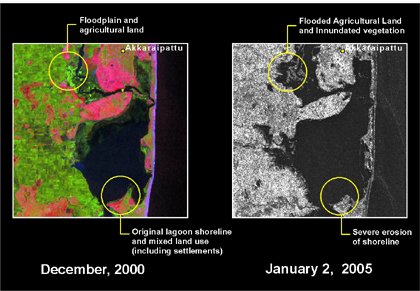
More on Tsunami Response and Geotech RADARSAT Tsunami Imagery. Canada's RADARSAT-1 satellite has been acquiring and continues to acquire imagery over the devastated regions in support of efforts by international governments and aid organizations. Space-based imagery is being used to assess disaster areas and direct relief efforts to the hundreds of thousands of people struggling to survive in the wake of the December 26th 2004 tsunamis that hit South Asia. The before and after images above are from RADARSAT. Whiz Band Satellite Imagery. A reader wrote after looking over satellite imagery last week. She said, "Wow, impressive before and after pictures aren't they?" Indeed. My publisher also noted to me that this was the first time everyone he knew (outside this industry) was all abuzz about the imagery. Those comments raise an interesting question from a journalistic perspective. How are these impressive pictures of relatively large areas, which are likely challenging to interpret by the lay reader, to be used in contrast to or in combination with images of bodies or the wounded and destitute? As always, journalists are trying hard to cover the tragedy in a responsible and moving way without going too far. As I noted last week, the availability of and interpretation and guidance provided by the imagery companies and other experts in this event has been extraordinary. I found it very interesting that the only coverage I saw/heard of why DigitalGlobe had the very timely imagery it did, was in another GIS newsletter. (If you know of other references, I'd like to know.) I, for one, would like those watching the imagery on the news or seeing them online or in print to learn that "it just so happened" that QuickBird was over the area and collecting when the event happened. Otherwise, the misconception, that the companies can move the satellite and point it at important events, may continue. So will the one that pretty much anything going on anywhere in the world is captured by some satellite or aircraft. (To be fair, that might be the case, but if it is so, the people behind it certainly don't want the world to know!) Simple Visualization. I've received many e-mails pointing to visualizations of the event. Some are quite large and others complex. I agree with reader Andrew who notes about this one: "simpler can be better at times:" Ten-Year-Old Geographer Saves Hundreds. A ten-year-old schoolgirl from outside London warned her vacationing family, and many others, of the impending tsunami. Sources say by doing so she saved hundreds of lives. Tilly Smith, from Oxshott, Surrey learned about the waves weeks before in school and when she saw the tide rush out at Maikhao beach in Phuket, Thailand, she told her mother. That message was relayed to others on the beach and the hotel staff. With the beach cleared, there were no serious injuries. Warning System. Five tribes inhabiting the Andaman and Nicobar Islands escaped unscathed from the recent tsunami. How? Anthropologists believe that traditional warnings read from the changed sounds of bird calls and other natural phenomena prompted the groups to move to higher ground in preparation for the quake and wave. Build a Tsunami Sensor on Your Own. Robert X. Cringely offers in a recent column that we best not wait for the various governments of the world to develop a tsunami warning system. We can do it ourselves. In "Wave of Change: How to Build a Global Internet Tsunami Warning System in a Month" he explains how. Much of his argument is about getting at the needed data, crunching the model, and getting the word out. That sounds like a lot of what we here in the geotechnologies world do in our day jobs. Tsunami Mapping Portal. DM Solutions launched a mapping portal addressing the Tsunami Disaster in the Indian Ocean Region. A note on the website specifically requests input from the community: "We encourage Data Providers to help us respond to Data User requirements by providing no-cost, high quality (geo-referenced) data that can be quickly and effectively integrated within this website and used to generate meaningful and helpful maps." The portal is built on MapServer with DM's Chameleon technology. NGA Remaps. The AP reports that NGA "is working around the clock to gather information, warn mariners, and begin the time-consuming task of recharting altered coastlines and ports throughout the region." It may take months. Shipping channel depths may have changed significantly, and so far most warnings say simply that effectively, things may not be where they have been. A Letter. Michael Gould responded to a comment I made last week and questioned some companies' "support" for relief efforts. "Great newsletter (Jan6) as always. Two comments: "1. Whose satellites? You say 'So far as I know, that agency [National Geospatial-Intelligence Agency] has no spy satellites.' Hmm, since when were we supposed to know which satellites the spies *really* use? :-) "2. re:Tsunami, what do you make of companies 'donating $X of software to the cause'?? [For] example: [C Tech]. "If they really cared they'd send cash to Red Cross or similar. Sending software nobody asked for or knows how to use, for the sake of publicity, is pretty dubious in my book. Also, sending a pile of CDs is definitely not worth $250,000 (Again, street value does not count when nobody asked for it.)" The editor responds: On the first issue, I wanted to highlight that the National Geospatial-Intelligence Agency has been very clear about its use of commercial satellite company resources, so I found it funny how the sentence was phrased. On the second, it's difficult to fault anyone who is genuinely trying to help those in need. And, clearly, people must come forward to claim C Tech's offer, so I suppose they'd be asking for it. I find it interesting that the offer is made only to those in the strickened areas. I should think making the software available to those who already know how to use it, even on the other side of the world would be valuable, too. Further, the decision to offer five free licenses and five reduced cost licenses appears to complicates matters. Finally, since I received this note the company has posted a webpage noting press coverage of its press release. It's instructive to contrast that effort with this statement from the ESRI website (no press releases sent): "Temporary keycodes, technical support, and other assistance are available 24 hours a day, seven days a week. This assistance is available to any organization with GIS needs regardless of its GIS platform." ESRI has some experience with this type of effort. The company stepped in with support during 9/11 and the hurricanes in Florida. By the way, other geospatial vendors are actively involved in the recovery and relief efforts. They've not put out press releases, but have spoken with me. Let's not forget to acknowledge their contributions, even if they are not documented for months or years to come. GISCorps. Martha Lombard e-mailed last week to share the news that that GISCorps is looking into providing GIS support to agencies in the areas affected by the tsunami, and other areas in need. Applications for potential volunteers are available on the website. Just this weekend, GISCorps selected its first volunteer who'll be on his way to the area soon. He will participate in a joint project with the Global MapAid (GMA) and MapAction. He will join GMA's two volunteers and travel to the affected areas in the next few weeks, according to an e-mail to volunteers and friends of GISCorps. You can learn more about how the first volunteer got to be the first volunteer on this blog. Two other groups are seeking volunteers for relief efforts through GISCorps. The organizations seek individuals with experience in disaster management and remote sensing, and who can work in harsh conditions. GISCorps is looking for potential volunteers (both for in field and "at home" work including grant writing and GIS analysis) and donations to support the volunteers' costs of travel and living expenses while on assignment. Contributions can be made to: URISA, 1460 Renaissance Dr, Suite 305 Park Ridge IL, 60068 and make sure your checks are made to: URISA, (with GISCorps-Tsunami Relief on the memo). Mercy Corps. Glenn Brooks, GIS Coordinator City of Woodinville, Washington, is working with Mercy Corps to provide GIS and remote sensing expertise. He has 50 volunteers lined up and is working on a project to set up a Mercy Corps Data Center to re-process data to support the Pacific Disaster Center. The goal is to process 500,000 GB of satellite image scenes received over the past two weeks, with more expected. He expects he'll need 3-6 remote sensing/GIS analysts 7 days a week. He notes that Central Washington University has offered its GIS lab to support the work. And, on a lighter note, Brooks comments that volunteers "are bound to receive volunteer overtime for this (i.e., coffee and donuts, once in awhile maybe a pizza)." Contributions to Mercy Corps on behalf of this effort are most welcome. (Clicking the link above will code a donation to the geospatial cause, even though the website does not confirm this, say my contacts at Mercy Corps.) Tsunami Photo Errors. The Times of India and other news outlets in Canada, Australia and elsewhere are acknowledging and reporting that photographs (not satellite images) of the recent tsunami in Asia were in fact images of another event in 2002. The images were actually photographs of a tidal bore on the Qiantangjiang River in China in 2002. For more on other errors see Snopes.com.

More on NGA Map Sale Change This week I received a position paper in the form of a press release from East View Cartographic stating its opposition to the change. The paper is titled, "Open Memorandum Concerning NGA's Federal Register Announcement to Withdraw Aeronautical Products (Maps, Charts, and Associated Data) from Public Access." Said the attached note: "East View Cartographic would like the GIS community to be aware of its efforts to keep important documents in the U.S. public domain." A representative of the company noted to me, the company is "hoping to draw interest to the topic." And, indeed the company, and other cartographic enterprises who have yet to speak out, should be interested. These maps are a key source for the creation of their products. The paper contends that NGA is not making the change for the reasons stated, (commercial concerns, terrorism concerns, data integrity concerns) but rather because of "the challenge of international copyright in the digital age as its products are moving from separate paper charts to integrated global databases. Thus far NGA has demonstrated institutional inflexibility and unwillingness to do the necessary work to keep its products in the public domain. Instead they [sic] find it easier simply to remove public access." The paper offers several alternatives to complete removal: 1) Redact the digital products and provide public versions. (I confess that I know what "redact" means this week only due to coverage of ongoing trials of soldiers in Iraq.) That, the paper argues, won't be difficult since it will need to be done anyway, to share data with the military and other non-public users. 2) Copyright the required products so that they cannot be copied for commercial products without permission. That's already done in the UK. This option, the paper contends, would be far preferable to complete withdrawal of sales. Finally, the paper notes, "'Going digital' and 'going global' should not be equated with 'going inaccessible' but that is where current NGA policies are taking us." The company offers a 24 page PDF that details its response to the NGA actions, including a table addressing its reasons and in a final appendix, pictures of children using the maps in question in school.

I first heard it in geospatial context recently during an interview discussing the state of remote sensing and agriculture. The point of the interviewee was that should farmers have access to digital imagery and they do or not do something that then causes a problem, they'll be libel. So, perhaps, many potential users have concluded, it's best to stay away. In December I attended an update meeting regarding GITA's Geospatially Enabling Community Collaboration program (GECCo) and one topic that came up regularly from the private sector participants was liability should a utility company, for example, share geospatial data. The feeling there, and from a state GIS coordinator I spoke with, was to recognize the potential liability and not to eliminate it, but rather to manage it. Earlier this week I found an article suggesting that many people knew of the upcoming tsunami and purposefully did not share that information. While a notification system was not in place, what might be the liability of an organization if it knows or expects such a disaster and fails to communicate it effectively? Or worse, does not even try to communicate it? Finally, just last night I heard an interview with Former White House counter-terrorism expert Richard Clarke. His new book outlines a theoretical "look back" from September 11, 2011 based on currently "known" threats. One of the "pretend" events mentioned in the book, based on material made public by the FBI was the threat by Al Qaeda to the casinos in Las Vegas. Apparently the FBI has in its files the video tapes made by the group in scoping the area in years past. What interested me was Clarke's comment that security personnel from the casinos were invited by the FBI to learn more about the threats and casino management, in many cases, told them not to attend. Why? Because if they "knew" about the threat by attending the meeting, and something happened, the casinos would be libel. Clearly, there's work to be done here. And, frankly, I don't know if the work is best done in the geospatial world with a "geospatial good Samaritan agreement" as has been suggested or in the policy world with some containment of liability or elsewhere. I do, however, feel strongly that the best measure of the success of geospatial data is in its widespread use. And, clearly, this type of concern, be it real or perceived, is holding geospatial data (and related technology use) back.

"In your January 6, 2005 issue you mention an Iranian campaign against the name 'Arabian Gulf,' and it reminded me of another campaign. Last spring I was walking by the Korean embassy in Washington, D.C. and saw a poster for a 'map exhibit.' Inside was an entire exhibit campaigning to name the Sea of Japan
Points of Interest Lucky 7. Acrobat Version 7 was released Wednesday. It comes in two versions, the $299 Standard edition and the $449 Professional edition with some higher-end features. Adobe changed the name of Acrobat Reader to Adobe Reader and added some key features: Reader can now add comments and make modifications to PDF files as long as the original PDF creator permits it using tools in the Professional version. This may help Bentley in its quest make PDF the engineering exchange format in its competition with Autodesk's DWF. GIS in Insurance: A Ways to Go. According to a new report from analysts at the Tower Group, insurance companies need to look beyond GIS use as a point solution. The report offers that more return can be expected when applying GIS to property management, real estate investment, company-owned agency management, and employee benefit services. MapInfo Bonuses. MapInfo filed papers in advance of its annual meeting to be held in February. Mark Cattini received a $462,000 bonus last year, on top of $330,000 in base pay (up from $300,000 last year). The bonus was up from $388,904. One director, Quinn H. Tran, will not stand for re-election, but the rest will. Quote of the Week. Raman Roy, who leads India's largest call center provider, Wipro Spectramind in Delhi, told an Asian Network reporter: "Geography is history because distances don't matter anymore. India happened to have a competent and skilled workforce who can speak good English - which is why we have taken over the industry." Quote of the Week II. Jupiter Research's Michael Gartenberg on the new "under $500" Mac mini from Apple: "It doesn't have a GPS system or a DVD player or leather seats, but it does come with the branding and associated cachet of those products." GIS Humor. Reader David passed on a bit of humor from the U.S. Census Bureau. It seems someone at Census renamed Bevis Lake, north of Seattle, to Butthead Lake. USGS calls it Bevis, but records show that before that name it was Beaver Lake. Most importantly, I suppose, is the name used by those who spend time there. That'd be local Boy Scouts. They call it Brinkly Lake, after the camp there, Camp Brinkly. Map Term Comes Out on Top. Attendees at the annual convention of the Linguistic Society of America on Friday chose the word or phrase that dominated national discourse over the course of the last year. It was "red state, blue state, purple state." I suppose we should be honored that a representational idea like this, keyed to a map, rose to the top of the pile. Perhaps, just perhaps, it will help non-map users respect the power and value of maps in politics and other pursuits. Chipping the Soccer Ball. A German company has devised location-emitting chips that can be put in soccer balls and players' shin pads. The idea is to provide more information to fans ("How close was the miss? 3.9 cm"), coaches ("Who's hustling?"), and referees ("Who hit who when?"). With much technology already dedicated to sports, it's hard to imagine something like this will not be widespread very soon. Moreover, it would be valuable to use on fans, perhaps, to track and prosectute the rowdy. Pay As You Go Auto Insurance for Young Drivers. The U.K.'s Norwich Union insurance company will offer a "Pay As You Drive" coverage for drivers between the ages of 18 and 21. A GPS tracks miles traveled and sends them via cell phone network back to the company. Premiums are based on time of day, distance, etc. The company suggests that insurance costs may fall 30% for young drivers. It also argues that it may encourage safer driving, that is driving during safer hours. GPS Exposes. A Massachusetts highway worker was charged with a crime because of a GPS in his snow plow. A Dunkin Donuts employee saw the incident and noted the worker leaving in the vehicle. She reported the incident. The state tracked the vehicle by time and location via the recently installed GPS, and arrested the driver. Local police noted that that's not really what the GPS is for, but alas can be used for such things. Re-Addressing. Ever wonder what issues are raised when a town gets "re-addressed" for 911? An article in a South Carolina paper (registration required) recounts what was clearly a heated discussion in Toccoa. New road names, private drives, and exactly how dispatchers will find the new roads were all raised. And, this is with just 15% of the town receiving their "addressing packets." More meetings are planned. Maps and Ads. Bugaboo makes baby strollers. Its latest campaign provides maps of several U.S. cities (the promo started in the UK) with suggested tours for adult and baby. Specific adult/baby landmarks are noted on the maps, along with, you guessed it, pictures of the strollers.
Kudos and Conundrums Kudos (concepts we applaud) IBM Opens Patents. That was the news this week, that Big Blue was making 500 of its patents available for free use by open source software developers. The idea is to encourage other companies and individuals to do the same, to create a sort of library for all to use. My first thought: what sort of patents are we talking about? Says the press release, they relate to "many aspects of software innovation. Several of the patents cover dynamic linking processes for operating systems. Another is valuable to file-export protocols. The pledged patents cover a wide spectrum, including patents on operating systems, databases, methods for testing programming interfaces, and even cursive text recognition." The whole list is here. There's a good summary, along with a bit of history of IBM and open source here. (free registration required) Conundrums (concepts we question/give us pause) No Warrant Required for GPS Tracking. A ruling by U.S. District Judge David N. Hurd contends that law enforcement need not pull a warrant to attach a GPS receiver to a suspect's car. The argument is that it's effectively the same as officers tailing a suspect in cars or via a helicopter. The case in question involves a federal trial to be held in Utica in which seven alleged Hells Angels members and associates face drug-trafficking charges. One challenge? Another county in New York made the opposite decision last spring. Many suggest a federal law on the matter will come in time.
Please note: Material used herein is often supplied by external sources and used as is. � Announcements Woolpert LLP became incorporated on January 1, 2005. Tele Atlas and Wanderlust Media, a producer and publisher of branded media, announced that they have entered into a joint promotion and marketing agreement for Tele Atlas' data and Wanderlust's Starboard Navigation - celebrity voice content for navigation systems. A survey announced at CES found that if consumers could give their high-tech car a voice, their top choice would be former 007 Sean Connery's famous Scottish brogue. Their second choice would be that of actor James Earl Jones' Darth Vader. Satellite Tracking of People LLC ("STOP") closed a new round of equity funding on December 21, 2004, and completed two simultaneous acquisitions. The company acquired the VeriTracks business line and the related key personnel from General Dynamics and, through a subsidiary, 100% of the stock of Verquis, LLC from Strategic Technologies, Inc. Bentley announced an extension to its "You Deserve Better" upgrade program; students, and educators can now download MicroStation PowerDraft 2D/3D CAD software at no cost. The software has a list price of US$1,295. MedicAlert is teaming with Wherify for a new medical bracelet. MedicAlert will offer a special service package to new members who sign up at select Wal-Mart stores beginning with the product's anticipated market launch during the second quarter 2005. The service package includes a MedicAlert Advantage membership and the Wherify service. Subscribers would not only get on-demand precision location information from Wherify, but MedicAlert's 24-Hour Emergency Response Service, 24-Hour Member Services Contact Center, Family Notification, Medication Dosage Service, Online Access and Updating, and Secure Medical Information Storage that guarantees a user's privacy. Microsoft Research launched its operations on Wednesday in India and signed a Memorandum of Understanding with the ministry of science and technology and ocean development to partner in research projects. One focus of this Lab? Geospatial research. This was first mentioned in GIS Monitor in December. Xybernaut Corporation has formed a Homeland Security division. The unit was created as a result of strong demand from both government and private sector customers for the company's homeland security and emergency preparedness solutions - including both systems and services. ESRI was named in the 2004 DM Review 100. The publication serves the business intelligence community and the list is based on a comprehensive survey of its readers. The only GIS vendor in the ranking, ESRI joined other top companies, including IBM, SAS, and Business Objects, chosen in the business intelligence, data warehousing, and data management industries. ESRI improved its ranking on the list to 33rd. Its ranking last year was 59th and was also the only GIS vendor named in the 2003 survey. I'm sure DM once stood for something - data management perhaps? The Urban and Regional Information Systems Association was recently accepted as a stakeholder on the Steering Committee of the Federal Geographic Data Committee (FGDC), a long-standing national consortium working to advance policy and standards for the development of the National Spatial Data Infrastructure (NSDI). Smart Data Strategies, Inc. (SDS) and Pictometry International Corp. have signed a marketing partnership. As part of the agreement, the two companies have created an integrated solution that offers their joint customers and new customers the ability to utilize each other's technology. geoLeaders announced that the Laboratory for Advanced Information Technology and Standards (LAITS) at George Mason University (GMU) has been selected as the winner of the 2004 Carbon Cup Open Geospatial Design Competition. MapInfo expects to record net charges totaling approximately $1.1 million, or $0.05 per share, for the first fiscal quarter of 2005 ending December 31, 2004. The net charges relate to the write-off of the remaining value of the company's 49 percent equity investment in Alps Mapping Co., Ltd., which is partially offset by a benefit resulting from recent changes in the United States tax laws. Exprodat Consulting Ltd. announced that Spatial Solutions Group will be the exclusive reseller of Exprodat Consulting's NitroView product for the Petroleum industry in the USA. NitroView is built on ESRI's ArcIMS HTML Viewer and extends the functionality of ArcIMS, providing the user with a powerful and easy-to-use tool for interacting with map-based data via a Web browser. GeoDecisions recently acquired the St. Louis-based GIS firm, Kinetic Solutions. Cadcorp announced that during the Association for Geographic Information (AGI) annual dinner and awards ceremony, held in London towards the end of 2004, its business partner, ISL, won the AGI Innovation and Best Practice in the Private Sector Award 2004, sponsored by Oracle. Tele Atlas announced an agreement with iBiquity Digital Corporation to provide dynamic traffic content utilizing HD Radio technology. The alliance aims to bring convenience and time savings to motorists around the country, who will be able to access real-time traffic feeds regarding accidents, road construction, and other travel events through digital HD Radio technology. � Contracts and Sales VARGIS, LLC has been awarded the GSA/FSS schedule contract #70 effective November 9, 2004. This twenty (20) year contract (GS-35F-0093R), which includes the first base period plus three five-year option periods following, is for general purpose commercial information technology services. The GSA schedule will allow government agencies easier access to the services offered by VARGIS. Fort Collins, Colorado has selected Accela Automation to be implemented as the City's new enterprise land management system. The City of Fontana, California has selected Hitachi Software Global Technology, Ltd. and its Any*GIS solution to integrate and serve spatial data and raster imagery in ArcSDE to its Autodesk Map users. NAVTEQ has been chosen by Lowrance to provide NAVTEQ maps of North America for use in the first Lowrance portable automotive turn-by-turn navigation GPS: the iWay 500c portable in-vehicle navigation system with MP3 player. The license agreement also formalizes the use of NAVTEQ maps in all of Lowrance's turn-by-turn navigation products launching in the continental United States and Canada over the next three years. LiDAR Services International (LSI) in association with Malaysian engineering partner Ground Data Solutions Sdn. Bhd. (GDS), is currently providing LiDAR data collection and data processing services to support a major project in Borneo, Indonesia. The company is also working on a survey in Ecuador for a large engineering company working on a new highway project connecting the coastal city of Guayaquil to the capital city of Quito. Trimble has supplied 156 of its GeoExplorer series of rugged GPS handheld receivers to Poland's Agency for Restructuring and Modernization of Agriculture. MapFrame Corporation announced Idaho Power Co. has selected MapFrame's FieldSmart applications to empower its workforce with a mobile GIS and field automation solution. Intermap Corporation has supplied National Grid Transco (NGT) with a computerized terrain map that provides land elevation every 5 meters across England. The order for the NEXTMap Britain data is valued at approximately CDN $986,000 and provides NGT with nationwide elevation data of unprecedented accuracy for use in gas pipeline planning. PlanGraphics Inc. won a $1.7 million contract from the New York Office of Cyber Security and Critical Protection to provide technologies that will help protect critical infrastructure in the state. Under the contract, PlanGraphics of Frankfort, Ky., will develop components of an Internet-based system to enable public safety personnel and state officials to find information about critical assets and infrastructure. The infrastructure data will be stored in a spatial data warehouse, or SDW and data catalog constructed by the office. The STAR INFORMATIC Group, which claims to be the largest European GIS vendor, announced that its STAR ELEC suite of spatially-enabled applications for the power-supply industry has been selected by Usine d'Electricit� de Metz (UEM), in Eastern France. The deal, worth EUR 1,000,000+, will see the deployment of STAR ELEC applications together with applications for the management of public lighting, urban heating and cable TV networks, over a period of 40 months. SiRF Technology Holdings, Inc. a provider of GPS-enabled location technology, announced its SiRFLoc MultiMode aided-GPS technology has been licensed by Research In Motion (RIM) for use with the SiRFstarIIe/LP chipset. RIM's BlackBerry 7520 device incorporates GPS technology from SiRF to help support a wide range of location, tracking, and navigation applications. geoLeaders received a grant from the National Spatial Data Infrastructure (NSDI) Cooperative Agreement Program (CAP) to establish Framework Data Services through an implementation of the CubeWerx CubeSERV WFS. � Products Applanix announced the launch of its POS LV 200 system (Position and Orientation System for Land Vehicles), at the 84th Annual TRB (Transportation Research Board) Meeting in Washington, January 9-13, 2005. POS LV 200 is designed to provide uninterrupted positioning and orientation information in areas where GPS reception is compromised, or unavailable. LizardTech announced the release of GeoExpress 5.0 with MrSID which includes image reprojection that enables users to reproject imagery from one coordinate reference system to a different coordinate reference system. Area of interest encoding is also available which allows users to specify different compression ratios within one image or mosaic to highlight a particular area in rich detail or obscure, a particularly sensitive area while preserving the surrounding area in vivid detail. GeoExpress JPEG 2000 encoding offers pre-defined image profiles (NPJE, EPJE) that ensure compliance with Department of Defense image standards. User-defined JPEG 2000 image profiles can be created to ensure consistent results across a project. GeoExpress also includes, mosaic, crop, and flexible multi-band support. ESRI announced additions to the data offered via ArcWeb Services. Highlights of the added data include premium imagery from GlobeXplorer, road network data from NAVTEQ, detailed data for Australia from MapData Sciences, and Italian data from ESRI Italia. Tadpole-Cartesia announced general availability of new functionality software for ESRI's ArcPad. Built using ArcGIS 9.0 technology, with support for ArcGIS 8.X included, the software gives field practicality to ESRI's ArcPad by automating the process of fully synchronizing fresh GIS data between ArcSDE or Personal Geodatabases and shapefiles stored on handheld devices when docked or online. ESRI announced the release of ArcGIS 9.0.1. This release represents the latest version of ESRI's integrated collection of GIS software products for building a complete GIS for organizations. ArcGIS 9.0.1 extends the supported platforms for ArcGIS Server, ArcGIS Engine, and ArcIMS ArcMap Server from Windows-based operating systems to the Linux and Solaris platforms. ArcGIS 9.0.1 also updates the ArcIMS Web Map Service (WMS) Connector. While not yet a product, HP Labs' large, table top screen is in development and was demoed on the main stage at the Consumer Electronics Show (CES) last week. The description in eWeek makes it sound like several of the "touch tables" (from Northrop Grumman and Mitsubushi Electronics Research Lab, MERL): "a coffee table with a screen built into the top that can be used to view city maps, put together puzzles and play games. Users will run their fingers over the map areas to move from street to street and likewise move their fingers across the tabletop to hook together puzzles or move game pieces." DeLorme unveiled $99 laptop GPS Earthmate LT-20 and new handheld, Earthmate GPS PN-20 which has a built-in screen at CES. It runs data from Topo USA 5.0, Street Atlas USA 2005, XMap 4.5, XMap GIS Editor. � Events QUALCOMM announced the open call for submissions for the BREW 2005 Developer Awards. BREW publishers and developers are encouraged to submit their top BREW applications by completing an online entry form and providing a demo of their application. The deadline for online nominations is March 11 and submission materials must be received by March 28. Finalists will be announced on the BREW 2005 Awards website on May 9, then winners will be revealed at the awards ceremony hosted during the BREW 2005 Conference, June 1-3, in San Diego. The GPS-Wireless 2005 conference will be held Feb. 24-25, 2005, at the Marriott San Francisco Airport Hotel. Registration fees go up after January 14. � Training Definiens Imaging announced the availability of its new Academic Software Subscription Program for eCognition Professional. Through the program, academic customers may purchase subscriptions for a minimum of three years to run multiple licenses of eCognition Professional. � People
Advertise With Us
Contact GIS Monitor is published by: GITC America, Inc.
Subscribe/Unsubscribe |