Letters, Points of Interest, Week in Review (Announcements, Contracts, Products, Events, Training and Education, Hires) Back Issues, Advertise, Contact, Subscribe/Unsubscribe If, for some reason you cannot read this document, visit: http://www.gismonitor.com/news/newsletter/archive/011504.php
Editor's Note Adena

More on Rental Cars and Telematics There are a few sides to this story. First off, there's a quote from analysts who suggest that roughly a quarter of the rental cars in the U.S. currently have such tracking devices. Second, newer tracking devices are using more advanced tools than those that simply track speed. Today's tools use "geofences" which track when vehicles cross in and out of areas of interest. Third, since business travelers are the most frequent renters of cars, there are concerns that such tracking could sour a business deals. That last one sound a bit far out? The example provided suggests that if a rental car company knows the renting individual's company, and that they do "due diligence" work, they might be able to connect a trip to say Busch Gardens as a potential future purchase. That might expose the deal, potentially sabotaging it. (I use Busch Gardens in my example since I did indeed work for a company charged with due diligence work at several of its locations.) One of the big concerns of consumer advocates is that renters are not made aware of the tracking devices. Contracts should disclose such information, and it seems most do, if only in tiny print. If one misses the fine print, it's unlikely they will notice the devices which are typically small, and well-concealed. And, perhaps as might be expected, at least one contract says that a device "may be" installed in a rental car. That's a way, perhaps, for rental companies to avoid equipping the whole fleet with tracking devices, but still "scaring" all their customers. There are reasons for rental customers to support the use of such devices, proponents remind critics. Such devices, by keeping track of the cars and sometimes damage done by specific renters, can keep costs down. Consumers do have some leverage. Lawsuits settled out of court with a Tucson, Arizona Budget Rent-a-Car franchise resulted in the company dropping enforcement of a charge for travel beyond a specified area for all drivers.

Just for context, let me share that it's been suggested to me that the French government has been tight-fisted with its public data. That makes independent GIS applications in France and its territories very difficult to create. That brings me to why this e-mail was so interesting. The news related in the e-mail is that the European Union has passed what we in the U.S. call "public records laws." The European Union has a directive (pdf) "on the re-use of public sector information." Dr. Yvo Volman, of the Directorate General for Information Policy, part of the European Commission gave a talk last week to the French Industrial and Information society. He noted that the directives are a set of minimal rules and he hoped that France would go beyond these. That same day, the French National Assembly added some details on the matter creating a new chapter on the dissemination of public numerical data to the existing laws from 1978. One part makes public numerical data collected or created by public sector employees available to the public, except under some circumstances. Further, the use of the data is free, with a few conditions, and commercial use is allowed. There may be a cost oriented fee, with a possibility of an additional royalty for those using the data for commercial use. The data in question includes national data as well as data created by national agencies and local governments. While this is a broad stroke review, it is clearly important for local, regional, national, and EU-wide GIS initiatives. I'd love to get some input from European readers, or those who've done work there, on the implications of this legislation.

Off Topic: What's on the Cover? The Chairman of the Department of Journalism at Boston University, Bob Zelnick, called the choice "inappropriate" and said it crossed the line "between what's reported as news and what's paid for by advertisers." He went on to say that readers, himself including, were easily deceived, as this was a story worthy of coverage. There was "nothing� to alert readers" that this was an advertisement. He explained that he was not aware that such a thing was done frequently, but each time it is done it "compounds the felony." I was surprised that the paper has a history of selling its front page in other ways. A clip on Greater Boston shows a tiny ad above the paper's banner "See Caldor's Back to School Sale." That got me thinking that while some of the covers of print publications in our industry may include some Photoshop slight of hand, I'm not aware of anything as egregious as "selling the front page." But, a few days later when the mail came, I received a publication with one of those "tiny" - ok not so tiny - ads on the cover. I believe it's the first one I've seen in this industry in my 15 years.

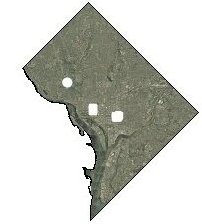
� Several readers, including one from Iran and one from Estonia, wrote to point out my error last week which placed Bam in Iraq. It is in Iran, the site of the recent devastating earthquake. � A reader wrote to share more information on "missing data" of the D.C. area.
"I appreciated your article 'USGS Imagery of Capitol Area "Blurred"'. There is more: the Washington D.C., government has deleted from its website all ortho imagery within 1/4 mile of the Capitol, White House, and Naval Observatory."
"See [this website] "Of course, detailed maps of D.C. are readily available to any tourist."
The editor notes: The image above highlights the "holes." The Atlas does make it clear that the dataset provided is incomplete as the larger scale image (left) reveals. � Tom Harvey AICP, Associate Planner in the Ontario (New York) County Planning Department wrote to share that state's method for protecting information after 9/11. He wanted to compare it to the Secret Service's methods highlighted last week. "In 2001, the New York State Office of Cybersecurity (formerly the Office for Technology) began a comprehensive digital orthophoto project...
"The state provided relevant data to each County as it was developed, but limited our ability to distribute certain photos identified as sensitive to the public and to our municipalities. Any and all requests for the sensitive data must be made to the Office of Cybersecurity. They have the following disclaimer on their website: 'For further instructions, please visit http://www.nysgis.state.ny.us/sensitive_unavailable.htm 'We appreciate your patience and understanding in this important matter and truly regret any inconvenience.' "The 'sensitive data' appear to be areas they believe would make good terrorist targets. You can request the data, but have to give your reason for needing it and furnish a valid government issued ID. "Much of the data is available online now..." � Terry Barton, GIS Programmer/Analyst at Middle Tennessee Electric Membership Corporation pointed out an interesting consequence of the Secret Service action. "I found the article 'USGS Imagery of Capitol Area "Blurred"' to be shocking. Looks [like] the Secret Service gave anyone that wants it an easy way to find sensitive areas around D.C. All they need to do is compare the 'new modified' photo to the older photos of the same area." � Mark Eustis shared his thoughts. "Mr. Aftergood [quoted here] is quite correct. There's nothing to be gained by this policy 'except in the case of unacknowledged government facilities.' To quote my 11-year-old niece: 'Well, duh.' "On any given day I can drive by and see personnel on the White House, around the Naval Observatory and the OEOB, and in front of the Capitol. I am certain those brave souls have more assets at their command than meets my ground-level eye. And although I may be curious, there isn't a single good reason why I need to know how many HVAC condensers, guard shacks, pigeon coops or Phalanx/RAM CIWS are on those buildings...or at any other 'sensitive' facility around DC for that matter. "Frankly, I don't give a 22cm pixel whether I can see the White House roof or not. Then again, if aerial images in general (such as those used by virtually every city or local government in the U.S.) were prohibited, well, then that's a bird of a different feather." � Patrick Moore of IntegralGIS wrote to consider what GIS/geography can bring to those outside our discipline. "I loved your Stan Rogers' Map recommendation [in last week's Points of Interest]. But beneath the surface of what Melissa Edwards is accomplishing with her maps is a pretty compelling reason to [put] GIS tools into hands of artists. OK, there is no doubt that cartographers are artists and some GIS people as well; however, we tend to view GIS as an engineering discipline. There are folks out there that have a different sense of space and place than we have been trained to think about it, and when those folks get a hold of the technology, it will be very interesting to see what comes out of it."

Points of Interest Wireless Watch. Microsoft's new SPOT technology powers a new, some say rather ugly (registration required), watch. The watch, in addition to keeping time can carry a schedule, receive short messages, show the latest weather, and the like. Challenges? The signal, part of the FM, (one writer suggests it should be called "watchband") is not available everywhere - only in some major cities. Some suggest the negative early press results from a product that was pushed to market too early. The watch must be charged about as often as a cell phone. On the other hand, like a cell phone, when you change time zones, it automatically resets to local time. Reader Matt noted, while crossing a time zone in the western U.S. recently, that the time changed on a cell phone within 100 yards of the border. Motorola to License WOZ Technology. Motorola Inc. is licensing wireless technology from Wheels of Zeus, a company led by Apple Computer co-founder Steve Wozniak. The technology enables services that can keep track of people, pets, or important possessions. Motorola plans "to use the technology within its home broadband division, which makes cable TV boxes, modems, and wireless products." Greenwich Appeals Again. The Board of Selectmen in Greenwich, Connecticut will appeal the recent judgment against the town that makes its GIS data available to the public. The December 30 ruling was the second against the town. Still, the town feels that "it has a reasonable chance of success." The defendant feels confident the town is simply delaying the inevitable. MapQuest Used to Fight Mortgage Fraud. Inman.com, a real estate website reports ($ for registration) that one of the tools used by those tracking mortgage fraud is fairly mundane: MapQuest. "Straw buyers," those who actually begin the process sometimes "buy" houses several hours away from their place of work. By geocoding work and intended purchased property, researchers can flag potential illegal activity. Open Source Lessons from Down Under. At the Linux and Open Source in Government conference in Adelaide Australian government employees told their stories of success with open source. How did the National Office for the Information Economy (NOIE) wind up with an open source publishing system? It was standards compliant. It turns out standards compliance was more important than cost or other factors. The Bureau of Rural Sciences uses open source GIS because it does what commercial programs cannot. "We've done as well as we have because we've looked for niches where we can fill needs that other products can't," said Antti Roppola from the bureau. Town Hopes to "Move Out." Reader Zach pointed out an article in the Rutland Herald that the town of Killington, Vermont is considered seceding from that state and joining New Hampshire. That would make it a "land locked" part of New Hampshire." That is, it'd be totally surrounded by Vermont. There are many political/legislative reasons such a change would be difficult, but Zach sees the bright side, "Think of all the work to GIS pros if this passed!" Data Sharing in Toledo: Thanks to EPA. The Toledo City Council (Ohio) passed legislation to allow the city to use Lucas County's GIS as part of a $450 million sewer system upgrade. The city needs to map its sanitary and storm sewers using GIS under a 2002 consent decree from the Environmental Protection Agency. Keith Fournier, director of information services for the county, describes the plan for working with the city this way, "It's like two libraries sharing books." Well said. And, let's hear it for the EPA, which is helping build NSDI!
� Announcements A complete report of Phases I through III of the American Society for Photogrammetry and Remote Sensing (ASPRS) 10-year Industry Forecast of Remote Sensing has been published in the January 2004 issue of Photogrammetric Engineering and Remote Sensing (PE&RS;). The executive summary is available or you can purchase the whole report. Telcontar announced its partnership with Aircept, a manufacturer and service provider for automatic vehicle location devices using the Aeris.net MicroBurst network. The American Association of Code Enforcement (AACE) has named ESRI as its Corporate Entity of the Year for 2003. TeleAtlas data is powering Pioneer's newest in-car navigation system, the AVIC-N1, TomTom Navigator USA for Palm, and NavMan's devices. The company also signed an agreement to work with Horizon Navigation. Intergraph Mapping and Geospatial Solutions and the Intergraph GeoSpatial Users Community (IGUC) announced the 2004 Geospatial Achievement Awards program, the worldwide competition that recognizes Intergraph users who have developed innovative, technologically advanced mapping and geospatial solutions to better serve their communities or constituencies. InfoNetrix is changing how it distributes its market intelligence products and services. Instead of annual reports, it will offer quarterly strategic reports, quarterly webcasts, a web-based delivery process, and other services. Utility Automation Integrators, Incorporated has changed its name to "UAI, Inc." to better reflect an ever-broadening market for its solutions. Telcontar announced the close of its $6.6M A1 round of funding. The round was entirely funded by existing investors or members of the current management team. Intergraph Mapping and Geospatial Solutions announced a new online geospatial infrastructure management solutions demo designed for public works professionals. Three Cadcorp software products - Cadcorp SIS Map Server, Cadcorp SIS Active Server Component, and Cadcorp GeognoSIS.NET - were submitted for compliance testing against the OpenGIS Web Map Service (WMS 1.1.1) and Web Feature Service (WFS 1.0.0) interface standards. Each passed. Now Cadcorp holds 10 compliance certificates. Ordnance Survey has made changes to enable customers to view aerial photographic imagery on the same screen as backdrop mapping so they can instantly compare product coverage and different representations of what is on the ground. They can also set their own automated schedule for receiving change-only updates. � Contracts and Sales EarthData purchased a second ADS40 digital sensor from Leica Geosystems. � Products
The German company Algo Vision LuraTech GmbH and the Swiss firm PDF Tools AG have continued to partner. PDF Tools AG will add the latest PDF compression tools from Algo Vision LuraTech GmbH to its range of PDF technology products. The FreeGIS Team announced the stable release 1.0.0 of the Geographic Information Tool Thuban. Thuban is an interactive viewer for geographic data layers. It can handle Shapefiles, PostgreSQL/PostGIS spatial databases, and raster data. It's released under GPL. The DSpatial project published release 0.2.2 of the DSpatial kernel. DSpatial is an open source project written in Delphi that aims to supply Delphi developers with geospatial analysis tools at no cost. According to a post from the development team on the product's discussion list, the product currently only displays selected formats; there are no analytical tools. ESRI's BusinessMap 3.5 is now shipping. Enhancements include GPS support, reporting tools, elevation maps, and support for raster images.
SOCET SET 5.1 will be released in March 2004. Version 5.1 of BAE Systems' SOCET SET features a new multi-processor function utilizes the power of multiple CPUs to improve the speed of extracting terrain by 50% or better, depending on the machine and the number of CPUs in use. World Construction Set 6 has new pricing. It currently sells for $500. Cadcorp is introducing a free desktop viewer product called Cadcorp SIS Map Browser. This is designed to view and query data served via WMS and WFS specifications, as well as GML 2.1.2 and Web Map Context XML data sources. ArcGIS Business Analyst is shipping. ArcGIS Business Analyst combines ESRI's leading GIS technology with extensive business, demographic, and consumer household data to assist users with mission-critical business decisions such as analyzing trade area markets and competition, finding the ideal site for a new store location, or targeting direct mail. The big deal? I believe this is the first release on Arc8.x technology. � Events Dan Quayle, Former Vice President of the United States, will be the featured speaker at the MAPPS Winter Conference, to be held January 30 through February 3 at the Wigwam Resort in Litchfield Park Phoenix, Arizona. The European Commission's Joint Research Centre (JRC) is organizing the tenth edition of the EC geographic information and geographic information systems (GI & GIS) workshop, to take place in Warsaw, Poland, from 23 to 25 June. Abstracts due March 15. UCLID Software announced webinars for January. The live 20-minute sessions are free of charge and cover parcel mapping with the highly effective IcoMap for ArcGIS v2.5. � Training and Education The Advanced Geospatial Laboratory of Northern Illinois University, an Intergraph Registered Research Laboratory, has completed development of a Web-based Virtual GIS Notebook that promotes GIS studies. The project, funded and supported through Intergraph's Education Grant Program, was designed as a resource for individuals with little or no GIS experience and is an exclusive privilege of Intergraph GeoSpatial User Community (IGUC) membership. To use the Virtual GIS Notebook, IGUC members can simply visit the website and log in with their member number. � Hires i-cubed appointed Tayin Hippeli to head the new Technical Sales Support Group,. Justin Doucette will serve as a Project Manager, overseeing projects involving orthorectification, digital elevation model creation, and vector extraction. Senior Image Analyst, Eric Russell, will provide image analysis, project management, and market development services.
Advertise With Us
Contact GIS Monitor is published by: GITC America, Inc.
Subscribe/Unsubscribe |