Letters, Points of Interest, Kudos and Conundrums, Week in Review (Announcements, Contracts, Products, Events, Training, Hires) Back Issues, Advertise, Contact, Subscribe/Unsubscribe If, for some reason you cannot read this document, visit: http://www.gismonitor.com/news/newsletter/archive/040804.php
Surveying puzzle you? Get unpuzzled. Sign up for a free subscription to Professional Surveyor Magazine. (U.S. residents only; postal fees apply for international subscribers.)
Government Involvement in USGIF Raises Eyebrows The provision for foundation funding, which passed the House bill, did not pass through the House-Senate Conference Committee, authorized "funds for a foundation focused on education and outreach for the geospatial intelligence field." It was authored, according to Chappie, by House Intelligence staff member, John Stopher. One of his jobs on the committee involves oversight of the National Geospatial Intelligence Agency (NGA). Stopher has been on the House Intelligence Committee for six years, and comes from an academic background. He's on the State University of New York at Buffalo's Dean's Council for the School of Engineering and Applied Science and is an alumnus of that program. Stopher is also listed as Director in the articles of incorporation for USGIF, filed on January 22. Stopher, at the first board meeting, did not put his name up for the board and is not currently involved, said USGIF President Stuart Shea. Stopher did attend a USGIF March 26 event in Tysons Corner, Virginia along with NGA head General Clapper. Stopher was reportedly the only house staffer in attendance. While initially Shea maintained no wrong was done, in the end he admitted, "it probably wasn't something that he [Stopher] necessarily should do" and that he knew of the $500,000 provision. Chappie notes those in and outside government see this connection as "an insurmountable conflict of interest that could potentially damage the credibility of the intelligence panel." Steven Aftergood, director of the Federation of American Scientist's Project on Government Secrecy, was succinct: "This stinks." He went on, "This is positively shameless. It goes beyond that normal state of affairs and starts to appear like an ethics violation." He has more to say in Secrecy News. A Space Imaging representative quoted in Chappie's article notes that Stopher "has seen the value that high resolution satellite imagery - when married with geospatial technologies" and others maintain he is passionate in his advocacy for the technology. Space Imaging is one company not currently listed as an intended USGIF member.

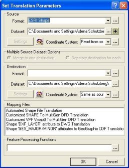
Review: Safe Software FME Suite As Safe Software has grown, so too has its reach. I'd be hard pressed to find anyone but a newbie in the industry who had not heard of the company, or downloaded the evaluation version of one of the company's products in 2004. It's been a few years since I had my hands on FME, so I deemed it worth a fresh look. Installation is quick and painless. Users request a license via e-mail or an online form. I received mine the same day I requested it. There was one oddity in the installation: all of my GIS data's icons were switched from their normal icon to an FME icon. It was odd to see my DBFs and SHPs with the cylindrical FME icon. Safe's Dale Lutz confirmed that was indeed a bug and is fixed in the next version. The current version of the core product is called Suite FME Suite 2004. It has three components: FME Universal Translator (the quick, "I don't want to be bothered with choices" tool), FME WorkBench (a visual environment for building custom translators), and FME Viewer (a data viewer). The FME documentation suggests that most users will find the Universal Translator does the job most of the time.
The Universal Translator is well laid out and demands little of the end user. Just drag and drop the source files onto the dialog and the software recognizes the format, and if available, the projection/coordinate system. (It's an interesting statement about the industry that only a handful of data types actually include coordinate information in the file format.) At this point you can have a look at the file in the Viewer. That's a comfort if you are not sure if you've chosen the correct file. With that confirmed, it's time to do the translation. I managed to leave the source and destination file names the same and was warned against doing so. To keep the product flexible, Safe uses the idea of a "mapping file" to control translation parameters. Again, most people will use the library of "mapping files" that Safe provides, but you may also create your own. Creating your own, or tweaking an existing mapping file can be done in FME WorkBench. Here, you can add "Feature Processing Functions" - things that are done to each feature in the dataset - to the translation process. Whether running a standard or enhanced process, upon completion, the resulting file can be viewed in the Viewer. Again, that's a comfort if you want to be sure you did what was intended. The Universal Translator's raw power can't be questioned for most purposes. Still, FME WorkBench offers quite a bit to those involved with data scrubbing at almost any level. Some of the simpler tasks-- such as renaming fields, filtering out specific data types, redefining field types or widths-- that I recall finding taxing in desktop software, can all be done here. Another nice bonus: if you work with several GIS products, you need not remember how to make the change in each package. All datasets are dealt with in the same way in FME WorkBench. Beyond such "cosmetic" changes that can be made to datasets lie more powerful, internal changes. These are handled by transformers. These transformers live in a "gallery" and are basically different functions applicable to a dataset or a feature type. These are very specific functions, such as: "2DCreator" which "Creates a two-dimensional feature using the parameters supplied, and sends it into the workspace for processing" or "HoleCounter" which "adds a new attribute whose value is the number of holes in the feature." With a long list of transformers you can do pretty much anything you like to your data. To be fair, it's possible to do this type of work with most GIS end-user or development environments, but this single environment for all datatypes is appealing and elegant.
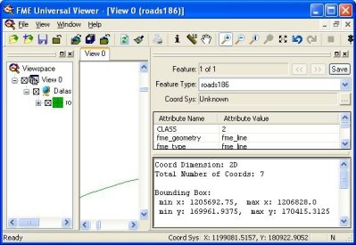
The FME Viewer, while a bit like some of the free viewers for GIS data, goes a bit farther. It includes a deeper view into the file - displaying coordinate information and tools to do queries (filters). This viewer is designed for those involved in translations and can be included in FME WorkBench workflows so that results can be graphically examined during processing. FME works seamlessly with several off-the-shelf products including GeoMedia, MapPoint, and ArcGIS. As I reported earlier this year, Safe is working closely with ESRI to develop several more integrated solutions for that company's desktop and Web products.

So, I was most interested to read about this year's Congress On the Future of Engineering Software (COFES) event. Described as the "industry's only annual think tank event" it drew some 250 players to the Arizona desert. I depend on Ralph Grabowski's coverage from UpFront.Ezine as my guide to topics addressed there that are close to our geospatial hearts. DRM. One topic raised by an attendee was Digital Rights Management (DRM). "How do companies protect themselves from IP (intellectual property) theft of CAD drawings?" The various answers from the vendors were interesting, but not foolproof, reports Grabowski. That's interesting as DRM is beginning to make waves in GIS, too. There's an educational event hosted by the GeoData Alliance at the upcoming ASPRS conference in Denver next month. Patent Lawsuits. One CEO explained he gathers patents to use as a type of trading card. If someone sues him, he'll have a patent "with which to work out a deal." I have not seen that strategy in action in the geospatial marketplace, but who knows? What Do We Want? A circular discussion between CAD users and vendors sounded familiar. The CAD users want the next big thing, but when vendors ask what it is, the reply was: "The vendors need to figure that out!" Standards. Intel launched an effort to develop a neutral 3D format some time ago. The existing open formats were not good enough. Says Grabowski: "CAD vendors would rather lock in their customers than subscribe to an open standard. So why is Intel doing this? To prepare the market for future performance level five to seven years from now, I'm told. Okay, but I leave the suite not convinced." DejaVu. I confess reading about COFES and getting a few e-mails from others in attendance reminded me of similar events I attended in my position with a GIS vendor. The events were for CAD companies, but we attended, too. There were "suites" where vendors gave demos. Attendance fees were high (for attendees and vendors) and like this year in Arizona, it rained quite a lot. (I recall a particularly wet event on Nantucket one year.) For COFES you must "apply for application" and can earn AIA continuing education credits. I noticed reps from ESRI and Leica on this year's COFES attendee list.

"Regarding the bit about Geoflash Pro 2004 including open source. Two points come to mind. "First of all, if it 'includes' open source, there may be an issue in that some open source licenses require that derivative works also be licensed under the same terms. "Secondly, at one point, the Open Source Initiative [OSI] tried to copyright the term 'Open Source.' I think [OSI] found [it] could not because it's too generic. But the reason [OSI] wanted to copyright it was specifically to limit its use in cases like this. "[The OSI] website says: 'We think the Open Source Definition captures what the great majority of the software community originally meant, and still mean, by the term 'Open Source.' However, the term has become widely used and its meaning has lost some precision. The OSI Certified mark is OSI's way of certifying that the license under which the software is distributed conforms to the OSD; the generic term 'Open Source' cannot provide that assurance, but we still encourage use of the term 'Open Source' to mean conformance to the OSD. For information about the OSI Certified mark, and for a list of licenses that OSI has approved as conforming to the OSD, see the OSD Certification Mark page.' "They have a long list of approved licenses [here] and there is much good spatial software available under these kinds of licenses. For the most comprehensive list, you can go [here]." The editor notes: I will be attending the Open Source GIS Conference 2004 and Second Annual MapServer User Meeting in Ottawa in June. GIS Monitor is proud to be a media sponsor of the event. � Lucia Barbato at Texas Tech University shared a story that combines two topics that GIS Monitor readers find fascinating: cats and science fairs. "I recently learned of a first place science fair award going to a pair of 6th grade elementary school girls from Lubbock, Texas who placed GPS units on their cats to see where they went. The students used a cat harness and sewed an eye glass case to the bottom. The GPS unit fit snugly in the eye glass case. Once the cats got used to the contraption, they were left to wander. When the cats (ultimately) returned home and the data from the GPS units processed, one student was concerned to learn that her cat was roaming across busy streets at night. Interestingly the cats' wanderings followed a repeated pattern of going out a certain distance and then returning home at about a fixed circumference from home." The editor replies: I find that fascinating. And, to put things in perspective, it seems these cats' wild cousins also like crossing streets at night. As a former science fair judge, I'm pleased to see kids diving into this technology. I was a bit bored with experiments examining the spots made by paint dropped from various heights.
Points of Interest Non-geographic Maps. The April 6, 2004, issue of the Proceedings of the National Academy of Sciences (PNAS) features work from researchers in computer, information and cognitive sciences, mathematics, geography, and psychology who created and explored maps of science. These non-geographic maps cover topics such as the relationships between disciplines or the marketplace. Twelve of the papers, including a team from Penn State, received National Science Foundation funding. Thanks to reader Ric for the pointer. Open Standards and Intellectual Property Exchange. An article at CNET discusses the recent "agreement" between Sun and Microsoft. It includes payment of monies back and forth and the opportunity to get inside each other's software. "The agreement rests squarely in the realm of intellectual-property exchange, not on open standards." That, argues the author, will not stop Sun from pushing for open standards. The agreement on intellectual property exchange sounds to me just like the two-year-old agreement between ESRI and Bentley. Steal This Phone! CeBIT, the largest tech fair in the world, wound up last week in Germany. A seemingly-clever thief tried to swipe a prototype Siemens phone. Once the phone was noted to be missing, the engineer behind the Assisted GPS tracking used in the phone got to work. By sending hidden SMS messages to the phone, the tracking was activated and the phone confiscated. To be clear, in production models users must "turn on" tracking. The prototype just happened to have it on anyway. The Lure of Location-based Games. Mogi, the hottest location-based game was developed by Newt Games, based in Paris, France. Using a mobile phone players use an add-on layer to the map of Tokyo to seek out various objects in real space. The lure, as described by an avid player, has more to do with the interactive aspects: running into another player. Says a recent speaker at the Game Developer's Conference in San Jose, "Trading is a very social game mechanic, very lightweight, very mainstream." So, while the location aspect of the game may make doing errands more interesting, it's the connection with others that's key. The Latest on GOS V2. GIS users gathered, beginning March 8, to put together plans for a new version of Geodata.gov. A requirements document will include their input, as well as lessons learned from the existing portal, and from the Open GIS Consortium's pilot portal. In April there will be a formal Request for Comments on the document. If funding is available, the Request for Proposal will be issued in June or July 2004 for an anticipated award before October 1, 2004. Your House on the Cover. Sometimes TV Guide has several special covers so collectors have to buy more issues. But Reason, a libertarian magazine, has that publication beat. In June each of the 40,000 subscribers will receive (New York Times, registration required) a customized cover with a satellite image of their neighborhood. The subscriber's house will be circled. The clever ploy supports an article on privacy by Declan McCullagh. GPS is a Verb. "They were able to GPS the entire perimeter today." That's a quote from Kristy Wumkes, fire information officer for the Picnic Rock Fire in Colorado. Evacuees were able to return home Monday. I fear this change in usage of GPS will cause even more confusion about how GPS works. As a verb it sounds active - like receivers (they are called receivers for a reason!) are sending out signals, when in fact they are passive devices. Another NGA Award Coming. I can share the headline but no details: NGA Plans Second NextView Award by End of September according to DefenseNews.com.
Kudos and Conundrums Kudos (concepts we applaud) Home, Spot! A social worker and a dog trainer teamed up in Israel to start the Alzheimer's Aid Dog project. The one current graduate, a collie, is now a service dog paired with an early stage Alzheimer's patient. While helping with daily things like a wet reminder to get up in the morning, the dog provides location-based services, too. Simply saying the words "take me home" (in Hebrew it's one word) the dog will lead the patient home. The dog sports a collar with GPS providing the caregivers and family members extra security should the pair stray too far. GIS Leader Profiled in Post. The Washington Post (free registration required) profiles EarthData CEO Anne Hale Miglarese. Nice to see women in GIS covered outside of our small world. Conundrums (concepts we question) Who Knows Where? I read in a few places about "text tracking," including an implementation from Internav Tracking Services. "Text tracking" uses SMS to share location information of cell phones. The oddity: there are reports that suggest it's possible to query location information without the user knowing, or even communicating with the phone's carrier. From what I gather, permission to track is required, but notification that tracking is happening is not necessarily provided. Would you provide permission if you couldn't know when your location was queried? Hello, MapQuest? Officials from towns in North Carolina's Outer Banks are trying to curb traffic. According to the local paper, they will contact MapQuest and similar services to try to get them to route traffic around the Southern Shores. Can you call MapQuest and make such a request? Is it perhaps better to contact NAVTEQ or GDT and tell them the streets are dead-ends? Would they believe you? Location-based Fraud. MSNBC reports on which countries are the source of the most fraudulent purchases on the Internet. What's a retailer to do? Some simply block access to certain IP addresses, effectively taking that country of the customer list. Others use fraud detection software. But thieves are smart and use proxies in other countries or simply change over to satellite-based Internet access. Just as all AOL users appear to be Virginia, many satellite access surfers appear to be from Denmark.
� Announcements Hitachi Software Engineering Co., Ltd Japan, has launched the image publishing website PiXterra. PiXterra distributes 40 GB of 60-centimeter Quickbird satellite image data covering the central area of Tokyo using ER Mapper's Image Web Server and ECW image database format. The American Society for Photogrammetry and Remote Sensing (ASPRS) released a draft position paper on the vertical accuracy reporting requirements for LiDAR-derived elevation data developed by the ASPRS LiDAR Committee's Working Group on LiDAR guidelines and standards. This draft is being made available for public comment and feedback with the intention of having an official ASPRS position paper approved at the upcoming annual conference in Denver in May. The Intergraph GeoSpatial Users Community (IGUC) announced the implementation of online message boards for its Networks Program. The IGUC Networks are forums for users to provide direct comment and feedback about Intergraph Mapping and Geospatial Solutions' product planning, development, priorities, and direction. The online message boards have been added as an integral part of the IGUC Network program, serving as electronic discussion forums for Network members. The Centers for Disease Control and Prevention (CDC) announced that more than $3.5 million will be awarded to 10 institutions for new research on Lyme disease. One award, to Durland Fish at Yale (New Haven, Connecticut) will lead to the development of a GIS-based surface map of the population density of nymphal ticks and prevalence of Lyme disease spirochete infection to estimate human infection risk in the eastern United States. � Contracts and Sales The City of Bath, Maine has launched its online GIS website using DeLorme XMap/GIS Editor and XMap Web 3.0 - GIS software for creating, analyzing, and publishing GIS data online. DeLorme hosts the website. � Products GeoFusion offers the GeoPlayer Mars demo which allows you to explore Mars on desktop PCs and laptop computers. The demo is a lower resolution version of GeoFusion's Mars exhibit at the National Geographic Museum at Explorer's Hall in Washington, D.C. This program was created with the GeoMatrix Toolkit by GeoFusion, Inc. and works with most PC graphics hardware that supports OpenGL and texture mapping. Thales Navigation introduced a post-processing differential correction option that delivers sub-meter accuracy to its popular MobileMapper handheld, GPS-based, geographic information system (GIS) data collector. The post-processing differential correction software is able to deliver 50 cm accuracy on baselines up to 50 km, using an external antenna, and 70 cm accuracy on the same baseline up to 50 km using the internal antenna. When I reviewed this product last year, several readers suggested this was a necessary add-on. InfoNetrix announced the second annual strategic market intelligence report in its 2004 Market Horizons Reports Series entitled, "Geospatial & Field Automation Solutions (GFAS) in the North American Utility Marketplace: 2003-2007." NAC Geographic Products Inc. and SafeAngel Ltd. (UK) reached an agreement to incorporate the NAC addressing standard into the SafeAngel Public Platform. SafeAngel develops middleware for the emerging enterprise location-based service market, and targets areas such as service provision by location, rapid urban response systems, and large scale human management using wireless GPS technology. In addition to the more traditional tracking, navigation and fleet management are also included. GEO CONCEPT SA announced a major new version of GeoConcept Dispatcher, its vehicle routing, scheduling, and dispatching solution for field services and mobile sales forces. Existing functions are faster (speed, display quality, user-friendliness, and ease of use) and performance is improved tenfold, according to the press release. ESRI announced its plans to release ArcGIS Server, an enterprise application server that gives distributed users access to GIS functionality via a centralized shared server. ArcGIS Server deploys GIS functionality, previously available only in GIS desktop solutions, in an information technology (IT) standards-based server environment. This product has been pre-announced for about a year. It will ship with ArcGIS 9. When? The release did not provide that information. KOREM Inc. released Push'n'See v. 4.7 for MapXtreme Java Edition. The product has been significantly enhanced with new capabilities, advanced features, and now offers two extensions for additional GIS and analysis functionalities. Making Community Connections: The Orton Family Foundation Community Mapping Program is a new book from ESRI Press designed to bring teams of teachers and their students together with community members to study problems, resources, conditions, and other matters of interest and importance to the community. MapInfo Corp. announced the release of its Smart Site Solutions software, which was developed for businesses that need to optimize their real estate deployment strategies. Avenza Systems Inc. released MAPublisher 6.0 for Adobe Illustrator. MAPublisher 6.0 is mapmaking software used to produce high quality maps from GIS data. New functionality in MAPublisher 6.0 includes support for Adobe Illustrator CS, new floating MAP Views palette, improved drag-and-drop projecting, support for Illustrator symbols and styles, and import/export support for additional map data file formats. Blue Marble Geographics released a TIGER/Line 2003 Data package with their TIGER Translator kits. This data contains important updates to TIGER including new economic census information. ESRI announced that RouteMAP IMS is now available with European and Canadian data. Maporama International launched Maporama Web Services 2004 v1.2 including two new major services "Check Address" (to verify that an address entered on a e-commerce website or present in a corporate database or an information system actually exists) and "POI Look Up" Web Services. � Events The GeoData Alliance and the Open GIS Consortium, Inc. (OGC) invite interested parties to learn about the requirements for and the application of digital rights management (DRM) to geographic activities in a session May 24, 2004 at the Denver, Colorado Adam's Mark Hotel. The session is being held in conjunction with the ASPRS conference, which runs May 23-28, 2004. � Training � Hires Bill Landis has assumed the role of Chief Operating Officer of Aerials Express, the Tempe-based national aerial photography firm started by his father Jerry Landis. Daniel Ormsby joined GIS supplier Innogistic Software plc (Bristol, UK) as Business Development Manager.
Advertise With Us
Contact GIS Monitor is published by: GITC America, Inc.
Subscribe/Unsubscribe |