Letters, Points of Interest, Kudos and Conundrums, Week in Review (Announcements, Contracts, Products, Events, Training, Hires) Back Issues, Advertise, Contact, Subscribe/Unsubscribe If, for some reason you cannot read this document, visit: http://www.gismonitor.com/news/newsletter/archive/041504.php
Win the handheld that works as hard as you: TDS Recon(TM). Recon survives drops, blazing heat, subzero cold or driving rain, and runs Windows Mobile.
Now, we are not detectives but, due to the circumstances of inquiry, we wanted to help out. I pointed GITC America's managing editor Patty Smith to the local paper that I used as a source on the story. She called the paper, but the staff alas did not have electronic versions of back issues. A paper staffer suggested she call the local library. The reference librarian there dug up and forwarded the electronic copies of the paper's articles. Reading through them, Patty found enough information to know who to call next: an organization with which the missing person worked. In about half an hour Patty called back the inquirer with the information. The caller noted spending hours on the task with no luck. We were happy to help.

Placement Part of the reason for the push from advertisers to enter "new" editorial space, says the article, is the success they've had in the "entertainment" space. Sears sponsors Extreme Makeover: Home Edition and cans of Coke or Reece's Pieces appear in movies. It turns out ad placements in video games are particularly effective since, as a friend put it, "your senses are hyper-sensitive" when you traipse through those virtual worlds. Oddly, though, players note that real-life products in those worlds make them seem all the more real. But, those prime time TV shows, movies and video games are classified as entertainment, not news, some argue, so such placements are acceptable. But, there are those who argue that the entertainment divisions of the networks are having more and more impact on how TV news looks. And, advertisers have been known to produce "news-like" segments that are offered free, especially to smaller market newsrooms who may not have the staff to fill a thirty-minute newscast. Add a two minute health piece from a large drug company, and you can fill the gap! That of course, brings us to our marketplace, the geospatial marketplace. How do advertisers fit into industry "news" publications? What is their role? What is the role of the publications - electronic or otherwise? And, where does the line fall between editorial and advertising? Are we on a slippery slope? I, for one, have been asking this question since GIS Monitor was launched. At times, I've asked readers. An overwhelming majority of readers prefer to receive GIS Monitor free and "let" advertisers pay. (That's how most free trade publications work.) We listened and have continued to encourage advertising from those who want to speak to our reader community as well as those who want to support the type of coverage GIS Monitor provides. Interestingly, in the two or three situations where readers have suggested I "kissed up" to vendors, those vendors had never (and still have not) advertised! On the other hand, vendors that now and again appear in a less that stunning light in this publication, do advertise. I hope that means we've constructed a publication that will withstand what may well be a fad in advertising. Don't expect product placements in GIS Monitor, nor advertorials, nor articles written by vendors. Our advertisers give me the opportunity to speak candidly to the industry and that's a responsibility I take very seriously.
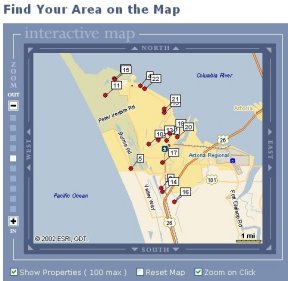
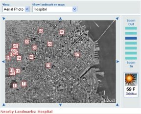
Windermere Real Estate, a western U.S.-focused residential real estate company launched PropertyPoint (left). It "allows users to emulate the natural process of house hunting by virtually displaying MLS listings using map coordinates and visual landmarks." I confess that I don't recall house hunting being a natural process, but then, eight years ago, it entailed driving around the Boston area with an agent. The Windemere application is slick and visitors to it would certainly not be thinking "Wow, I'm using GIS Web Services!" while using it. They might, however, be puzzled that there is no "help" button for the application. Is the general public ready for that? Another real estate-related website (below) has a different vision for Web Service and real estate. Realbird encourages real estate agents to link their websites to its applications, which are built from Web Services. Realbird provides some free and some non-free imagery and maps. My quick look revealed imagery from GlobeXplorer/USGS and maps from ESRI/GDT. That said, there's a twist. Realbird is part of the DonationChannel Inc. which provides services and encourages independent service professionals, like real estate agents, to contribute to local schools in exchange for their use.
Finally, when a press release from GlobeXplorer crossed my desk noting its partnership with DigitalGlobe, I was a bit puzzled by its Web Services offerings. After a discussion with Paul Smith at GlobeExplorer I understood that company offers its partners data via its own API, via OGC's Web Map Service (WMS), and via ESRI's ArcIMS. While I still think of the company as "in the geospatial space" it is owned by Stewart, a land management company, and so is very tuned in to real estate. These websites and announcements all bode very well for geospatial Web Services. It also makes me wonder about those companies that aimed services at the agricultural markets. Perhaps they were simply too early? Or the data was not at the scale required? Or, there's simply more business in the built environment than the planted one?
Build The National Map in Your Spare Time
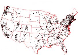
Volunteers are assigned a quad sheet area (volunteer quads assigned as of Jan 1, 2001 are at left) and asked to document landmark buildings, facilities, and objects. Documenting basically means collecting GPS data points and some descriptive information and delivering them in a spreadsheet via the Internet. While there is no strict time frame for delivery, the goal is that sheets are completed in about a year.
"You might not be aware that Bill Thoen and I published a series of articles in Directions Magazine two years ago focusing on the technical aspects of this issue. Bill calls it 'vector steganography,' the technique of embedding hidden or secret messages in vector data. "Remarkably little research has been done on this. [�] I am very curious as to what solutions the vendors were proposing and even whether they are aware of any of this published work. Of course, no solution will be 'foolproof.' The most we can hope is that a secret message within a vector dataset will resist most attacks against it and survive [the] most common transformations made to it. If it does not, then we might simply decide that the dataset has been reworked enough to constitute a new, original map and leave it at that." � Larry C. Stout, P.E., GIS Manager in Hamilton County, Indiana wrote about the CAD side of DRM. "I've never been to this event [COFES, Congress On the Future of Engineering Software], and am not sure which vendors attend. I have been using CAD software along with GIS software since 1986. Last week I was at Bentley DevCon 2004 (a developers conference for MicroStation users). Bentley has supported DRM in a fairly robust way in MicroStation V8 for a couple of years now. If you are not aware of this you may want to investigate." The editor notes: According to the COFES website, Bentley did not attend that event as an exhibitor, nor were any employees listed as attendees.
Points of Interest New WMS and WFS Connectors Available. Several readers noted recently waiting for updated connectors for ArcIMS. They are available for download. There's also a new online help resource. A Better Locating Technology? GPS and cell network locating techniques have all sorts of challenges including the fact that they are not too accurate and can't tell which way you are facing. But a technique now under development can, as long as your phone has a camera and you are in Cambridge, UK. Two researchers at the University of Cambridge are developing a system that will determine your position based on a photo you send of a building. A server will host images of all the buildings in Cambridge, and, adjusting for angle, time of day, and other features (like dogs and cars) in the image, will match it up. Then, the idea is, the system not only locates you with a high degree of certainty, it can begin giving you specific directions ("turn right") that other systems cannot. As an aid, the system will get a little locational "head start" help from the cell tower which delivers the messages. The ultimate use of the technique is unknown, but researchers have funding for a prototype for the city. Thanks to reader Atanas who sent on the link. Corner Jumping Illegal? Corner jumping means crossing a spot where four parcels come together (share a node for those thinking topologically) to get from one parcel to the one diagonally across from it. A hunter in Wyoming did just that last fall to get from one parcel of public land to another. He first carefully found a surveyor's stake using his GPS receiver. But, he was approached by a landowner and Game and Fish representative who informed him that his move was illegal. A circuit court judge deemed the hunter not guilty of trespass, though Wyoming law does state that owners of land have rights above the land, too. Here the Massachusetts Supreme Court ruled that there is "no place in the modern world" for the old doctrine that "he who owns the soil owns upward unto heaven." Careful where you step! More on Mogi. Wired reports on the hot location-based collecting game Mogi. Paul Baron, an avid player in Tokyo, sees it growing to include "cross-continent missions, team missions, missions or quests spanning days, (and) encouraging different cultures to collaborate." There's an interesting list of related games here. I have to say that while Mogi does have a group dynamic that geocaching does not, it shares many of the same qualities. Quote of the Week. "In-car systems are doomed, in much the same way car phones were doomed once mobile phones became small enough to carry." So says Mike Langberg of the San Jose Mercury News after using Televigation's TeleNav routing. Starting at just $5.99 a month, the writer found it worked just fine. But the required materials are still a bit complex to acquire: "Nextel phone with built-in GPS and the Java operating system. There are about a half-dozen models that meet these criteria� TeleNav's software [and a subscription] to Nextel's Total Connect data service." By the way, one of TeleNav's partners told me a few weeks ago he had his money on this as the killer app. Stay tuned!
Renumbering and GPS. An extra three miles added to a Utah road mean that exit signs have been wrongly numbered for years. The state's exit numbers are supposed to correlate with the mileage markers, but on I-15 which runs to the Idaho border, the numbers are wrong. So, this summer the state will renumber. The expected cost: $2-$3 million. And, of course, maps will need to be changed. The change, according to a piece by a Utah TV station, will also affect GPS navigation systems. The day I posted this tidbit on the website, Don Cooke sent this photo taken in Maine. He explains that many of the exits near this one were in fact assigned new numbers, so this one should perhaps read, "Still exit 8." Autodesk's Latest GIS Versions. Autodesk released its 2005 family of GIS products: Autodesk Map 3D 2005, Autodesk Raster Design 2005, and Autodesk MapGuide 6.5. New features include support for Oracle Spatial 10g and DWF. The story sounds much the same: the products "allow customers to integrate raw data from multiple sources and systems, ensure its accuracy, and share it throughout the lifecycle of a project."
Kudos and Conundrums Kudos (concepts we applaud) Mapping World Population Growth. PBS' Nova is airing a special Earth Day episode, World in the Balance, on April 20. One of the features on the website is an interactive map showing population growth worldwide.Conundrums (concepts we question) Picking a GIS Consultant. Fulton County, Pennsylvania is looking for a consultant to map its parcels. The gory details are available but the 17 bids returned based on 40 RFPs mailed range from $13,650 to $82,240 for the 11,000 parcels. No Data Sharing Via the U.S. Mail. Two out of state companies requested data from Livingston County, Michigan. The local paper describes the requests as Freedom of Information requests. In both cases, the response was, essentially, "the data will not be mailed." Sisnet Inc., of Boca Raton, Fla., which creates investigative databases for law enforcement and Data Mapping Solutions of Arizona, which is aiding in a property rights dispute, will have to come to Michigan to get the data. And, they'll have to pay, "the cost of the information plus 10 percent" to the assessor.
� Announcements NAVTEQ Traffic, a solution for North American navigation systems, is slated for launch in the third quarter of this year. The solution enables navigation systems to provide personalized, real-time traffic information for a driver's chosen route. The 2004 Cooperative Agreements Program (CAP) will open for submissions on or about April 16, 2004. A total of $1,500,000 is available for funding this year. Approximately 50 awards are expected. The CAP is open to all U.S. organizations and seeks new participants. Meteorlogix was recently awarded a U.S. patent for its original work in weather, GIS, and location-based alerting. NovaLIS Technologies will partner with Satori Software, a Washington-based company specializing in address quality and mailing applications. Tadpole-Cartesia, Inc. announced a business partner agreement with Trimble enabling it to integrate its GO! Sync for ArcPad software with Trimble's Mapping and GIS products, including the GeoExplorer series of rugged GPS handheld receivers, the Trimble Recon rugged handheld data collectors, and GPS Pathfinder systems. Pitney Bowes Inc. will acquire all of the outstanding shares of Group 1 Software, Inc. for $23 per share, which net of cash on Group 1's balance sheet will cost the company approximately $321 million. Group 1 Software makes software that enhances mailing efficiency, data quality, and customer communications. It's hot in the marketing arena. California-based @Road will buy Vancouver-based MDSI. @Road basically does GPS-based fleet tracking. MDSI's Advantex uses complex business rules to schedule work requests and assign them to appropriate personnel. � Contracts and Sales Pictometry International Corp., provider of a system that captures digital aerial oblique and orthogonal images, has secured a licensing agreement for county-wide imagery and software with the Los Angeles County agencies. � Products AMERICAN FORESTS unveiled the latest in its CITYgreen software for ArcGIS. Garmin International Inc., a unit of Garmin Ltd. introduced the Foretrex 101, an economical wearable Global Positioning System (GPS) device. It runs on two AAA batteries. Global Mapper Version 5.09 is now available. The software "converts, edits, prints, tracks GPS, and allows you to utilize GIS functionality on your datasets." har*GIS, LLC introduced a new version of TruckMap, its package for field force automation. TruckMap 4.1 provides a set of vendor-independent tools specifically designed to improve complex workflow processes of organizations with mobile field crews that maintain distributed assets, such as utilities, local governments, and the communication, transportation, and route services industries. ESRI's ArcWeb Services can now do batch geocoding, obtain demographic reports for specified regions, and access new data that includes weather forecasts, world administrative boundaries, and maps of New Zealand. MapInfo Corporation debuted solutions for the health care industry. I have no idea if these are shrinkwrapped products or platforms or developer tools. Bradshaw Consulting Services, Inc. announced Fire/Rescue Analysis Tools (FAT), an ArcGIS extension that provides fire professionals with tools that assist in the review and analysis of response times, changing demands, station placement, and move-up. Psion Teklogix and Webraska unveiled PsiNav Pro, a transport management system that provides in-cab audio-visual navigation information for the home delivery, courier, and field service markets. Based on Psion Teklogix's netpad and powered by Webraska's SmartZone Navigation software, PsiNav Pro extracts delivery addresses from their daily delivery schedule and generates GPS-enabled, turn-by-turn navigation instructions. � Events Preetha Pulusani, President of Intergraph Mapping and Geospatial Solutions, will present a keynote address at the upcoming GML Days 2004, in Vancouver, BC, July 25 - 29. � Training � Hires Bob Scaer has been appointed CIO of Gannett Fleming, Inc. Want to be the FGDC Deputy Staff Director? This position is located in the Staff Directorate of the Federal Geographic Data Committee (FGDC), Geographic Information Office (GIO) of the U.S. Geological Survey.
Advertise With Us
Contact GIS Monitor is published by: GITC America, Inc.
Subscribe/Unsubscribe |