Letters, Points of Interest, Kudos and Conundrums, Week in Review (Announcements, Contracts, Products, Events, Hires) Back Issues, Advertise, Contact, Subscribe/Unsubscribe If, for some reason you cannot read this document, visit: http://www.gismonitor.com/news/newsletter/archive/060304.php
Last week a large number of delegates and exhibitors attended the Bentley Empowered Conference 2004 (BE) held in Orlando, Florida, USA. The conference included more than 428 different sessions. My colleague Jacques Sipkes, contributing editor, GIM International, shared the following report. Keynote Greg Bentley, one of the five Bentley brothers and CEO of Bentley Systems Inc, Bentley is an international company and it thus welcomes globalization. This view pays off quite well because there was a 13% revenue growth in 2003. Revenues reached $260 million. Revenues were up 8% in the first quarter of 2004. This expansion was also reflected in the purchase of companies in the electrical industry, Web publishing, and e-governance applications like the purchase of ISIS in the Netherlands (more on that below). Bentley considers training to be among the top two challenges in the industry and pointed out the company's educational arm, The Bentley Institute. Greg Bentley discussed MicroStation and ProjectWise, the company's flagship collaboration server product, and the four main divisions of Bentley Systems that are built on top of them: Bentley Building, Bentley Civil, Bentley Geospatial, and Bentley Plant. Bentley emphasized that there is overlap between these four divisions and that is where the strength of Bentley lies. He concluded that Bentley supports the philosophy of interoperability and mentioned a number of examples. One highlighted how Bentley's vision is parallel to Microsoft's because of the similar vision on XML queries. Bentley Geospatial A number of speakers including Keith Bentley, Director and Chief Technology Officer, and Bhupinder Singh, Vice President Platform Products of Bentley, reflected on the new features such as the new layer of domain-specific functionality that has been added with V8. MicroStation can now be configured to include building, civil, geospatial, and plant extensions. These extensions - TriForma, CivilPAK, GeoGraphics, and Schematics, were previously available only as add-on applications for MicroStation. In the new version things are standardized and the objectives of standardization are to make each project more repeatable, predictable, scalable, reusable, interoperable, and profitable. Geospatial Research Seminar During the geospatial research seminar a large number of scientists debated the integration of GIS, CAD, and AEC information, and the shared data management issues. The integration of new technologies such as LiDAR was also explored. The speakers intend to jointly publish a book in 2004 addressing the outstanding spatial information integration issues. Further Discussion Geospatial Topics The XML format? New to MicroStation V8 GeoSpatial are XML-based feature modeling and management environments, parametric cells, and particle trace rendering. XML is a way of data exchange; a way of talking between applications. The panel found that XML is enabling distribution to a lot of people, who would otherwise not have shared information. The panelists agreed that XML is a fundamental code for not only the Web, but also for metadata, messaging, etc. Another topic discussed was a Spatial-Enabled Managed Environment. Panelists felt that GIS is a bit outdated (GIS is dead?). Geospatial is a much more relevant concept. Location-based (LB) information is now disseminated to many applications in daily life and a lot of LB information will have to be managed. Organizations in general are not used to exchanging information so their systems are not made to handle this task. Dr. Xavier Lopez of Oracle stated that this is not a technical issue but an organizational one. Bentley-Oracle 10g Cooperation Dr. Xavier Lopez Director of Spatial Products, Oracle Corporation, delivered a presentation on the cooperation between Bentley and Oracle. This has been going on for eight years already, but activity has increased in the last half year. The newest release is ORACLE 10g where "g" stands for grid computing. Why did Oracle get involved in spatial? Because most of its customers have spatial locations in their business data; e.g., cell phones, Web portals, store locations, vehicle locations, asset locations, etc. In the beginning there was simple storage of geometry in a Data Base Management System (DBMS). Now things have become more complex and Oracle has responded. Points, imagery, networks, topological relations, parcels, and addresses can now be stored in Oracle 10g. The role of Oracle 10g is to store many different data types from a wide variety of sources, including spatial data types. Another approach is spatially-enabled business applications e.g., a city where ProjectWise can be used and integrated with Oracle 10g. This cooperation is beneficial because all business applications can be location-enabled and, for instance, raster, vector, and business data can be stored at the same time and be linked. Examples of use of Oracle 10g's spatial functions include the Ordnance Survey in the UK and the US Census Bureau 2010 Tiger Project. Other possible applications and users include agriculture, cadastre, mapping agencies, local authorities, cell phone companies, etc. Bentley and the ArcGIS Connector The ArcGIS Connector supports user-initiated or event-driven interoperability between Bentley ProjectWise (with the Geospatial Management extension) and the ESRI ArcSDE Geodatabase (server to server). The ArcGIS Connector supports an intelligent Extract, Modify, and Post paradigm. Bentley users can retrieve Geodatabase data for use in AEC and mapping DGN files in workflows, and later post the appropriate information for use by ESRI users. Bentley-Adobe Cooperation One of the new and enhanced core technologies for MicroStation V8 is MicroStation PDF Composer. The enhanced print core technology now includes support for Adobe PDF, the dominant standard for electronic deliverables in AEC. Users can publish composite, secure, compact, PDF deliverables sourced from DGN or DWG drawings (with raster and vector data), specifications, schedules, bills of material, and other project information in a multi-sheet rich information PDF format. The PDF document preserves the level and reference structures of MicroStation files and can include hyperlinks, digital signatures, and bookmarks. MicroStation support for PDF makes it easy for organizations to establish a PDF-based electronic delivery and to share process worldwide and across various disciplines. Adobe and Bentley are working jointly on key AEC market requirements for PDF for engineering called PDF/E. What issues are the PDF/E working group looking at? They are looking for: accuracy/scale, security, fonts, colors, plotters, metadata, multimedia, 3D, etc. The standard for 3D file format will be in future 3DIF. Bentley-ISIS Bentley recently purchased the Dutch company ISIS because of ISIS' experience with e-governance in the Dutch policy and planning environment. Bentley envisions using this knowledge on a much larger scale in other parts of the world. 2004 BE Awards of Excellence Ceremony
This event during the Bentley BE 2004 Conference was sponsored by McGraw Hill Construction publishers and the winners were announced during a dinner. Out of more than 160 nominees, twenty-one projects received BE Awards. Below are the winners of the Geospatial Awards. - AEC-GIS Vision: Oldham Metropolitan Borough Council, UK-Environmental Management

Department of Corrections
Letters
� Bruce Westcott wrote, regarding issues raised by Parr. "I think that what's important is looking at the possible mission statement components for any such organization. Would such an organization exist in order to: "Hold a conference, provide education, etc.? "I think the biggest opportunity for failure would be the lack of proper analysis, selection, and communication of what the critical purpose of such a group could be." � Other readers shared links to organizations that might serve as models of a "united front" including the Canadian Institute of GeoMatics and the recently formed Spatial Information Management Advisory Group (SIMAG). � Jim Bash, Associate Director of CAGIS (Chicago Area Geographic Information Study) asked about use of the word "notoriety" last week. "I'm just reading the May 27 GIS Monitor and was surprised at the use of the word notoriety as you applied it to Geographic Resource Technology. I've never heard of the company but to me being notorious is not a good thing! So I checked webster.com and their definition of notoriety was the state of being notorious and that definition says: 'generally known and talked of; especially: widely and unfavorably known.' "So I guess it doesn't have to be negative but thought I'd pass along my impression." The editor replies: I did select the wrong word. Geographic Resource Technology has gained some acclaim for its work. My apologies for suggesting otherwise. � Learon Dalby GIS Program Manager at the Arkansas Geographic Information Office shared thoughts on a quote from Mayor Bloomberg of New York. "Quote of the Week: 'I've never seen a terrorist with a map of a cornfield in his pocket." That was Mayor of New York, Michael Bloomberg, charging that Washington is steering vital anti-terrorism funds away from New York to low-priority areas in the nation's hinterlands.' "While I certainly understand the Mayor's frustrations I believe it is important to note that 'anti-terrorism funds' and homeland security funds are needed nationwide. I am sure New York needs far more money than Hoxie, AR but the fact remains events happen in Hoxie just as they do in New York City. I would agree the events may not be terrorist-induced, but I believe Homeland Security entails a much broader definition than just bad guys causing harm. I would also note that the mailbox bombings that occurred in 2002 took place in the nation's 'hinterlands.'"

Points of Interest Quincy Where? There's an actual group with this name. Each year people from villages, towns, and cities called Quincy, get together, in a Quincy location. This year the group will gather in Quincy, Pennsylvania. If you are from a Quincy, look them up, they are looking for new members! Making the Ultimate Map. That's the title of an article in this week's NewsWeek. Interviewed are Jack Dangermond of ESRI, John Frank of MetaCarta, David Schell of the Open GIS Consortium, among others. Do articles like this help the public understand what we do?
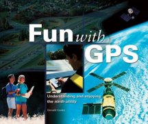
Heads Up for GPS Book. GDT Founder Don Cooke is authoring a book called Fun with GPS: Understanding and Enjoying the Ninth Utility, My ESRI News. Like many readers I'm part of several of ESRI's electronic mailing lists. Good news this week from the company: My ESRI News is "a 'spatially aware' service that sends personalized announcements only when there is news to report that is relevant to your region or industry interests." This service seems to replace "Direct ESRI" which provided info on events in my local geography. For example I got a flier for the NEGIS conference a few weeks ago. Autodesk once had a "customizable" electronic publication, TopLines, that's no longer published. CompStat Questions. R. Valeria Treves, a graduate student in geography at Hunter College, CUNY, wrote a scathing article questioning the role of CompStat. That's the computer mapping/statistics program often credited with cutting crime in New York City and boosting Rudy Giuliani to prominence as a "tough on crime" leader. One sentence that I found interesting: "Today Compstat technology is used in police departments across the nation and throughout the world, often peddled by consulting firms headed by Giuliani and various ex-NYPD top brass." No More Maps of Towns in Northern Ireland? Ordnance Survey of Northern Ireland (OSNI) said it may have to stop producing local street maps. Sales of some maps are fewer than 50 per year and several local councils have not stepped up to partner in production. That means that maps of Belfast (which sell well) and those of Lisburn and Banbridge (whose councils have agreed to partner in production), will continue to be published. Others are in jeopardy. New Draft CAD Specification. The Web3D Consortium has completed the first working draft of the CAD Distillation Format (CDF) specification -- an open, royalty-free file format to distill the essential elements of complex CAD and architectural data for use throughout an enterprise. CDF enables CAD data to be used in documentation, training, sales, and marketing departments to increase productivity, cut costs, and generate new revenue streams -- without exposing sensitive design information. The hope is it will in time become an ISO standard. Done. Three-thousand four hundred forty-five miles after starting from Irvine California, Roopinder Tara rolled into Boston, Massachusetts to dip his bike wheel into the Atlantic. It's been a pleasant diversion to read his daily log and view pictures of a transect of America for the last month. I highly recommend the Epilogue. Tara had ups and downs (including food poisoning) but kept the roughly 110 mile/day pace with no adverse affects.
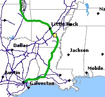
Tracking the Train. The Challenger 3985 is a Union Pacific train built in 1943. The world's largest operating steam locomotive is on a ten-state tour of the U.S. It used to burn coal but now burns oil and if you want to know where it is, it's got a GPS in one of the cars. A system provides updates every 15 minutes to an online map (left). Intel Working on LBS Chips. Executives in Taipei report that Intel is indeed working on computer chips that can determine location. The idea is to use them in conjunction with new location abilities to be released in Microsoft's Longhorn, the next version of Windows. If this plays out, and location aware chips appear in nearly every computer, that will hopefully create a more demanding community for location-based services.

Kudos and Conundrums Kudos (concepts we applaud) In the Middle. Massachusetts Association of Land Surveyors and Civil Engineers. (MALSCE) heeded the request of the U.S. Census Bureau and has found the center of population of the Commonwealth. It's on a high school athletic field in Natick. This week, the organization will plant a marker there and demonstrate how GPS works. MALSCE "hopes to forge a relationship with the high school, possibly offering engineering and career programs through the year."Conundrums (concepts we question) Bringing Enhancement to Music. There's quite a bit of discussion about using wireless to somehow invisibly provide information about locations, see for example GLOBALBASE (thanks to reader Allan for the link). Just recently there was a trial of a handheld that provides real-time information about the music being played at a symphony concert. In addition to information about the program, there are notes about what to listen for, and short videos. Reviews, according the New York Times (registration required), were mixed. While I'm a big fan of subtitles in films and surtitles in opera, I think multimedia would be quite a distraction.
Please note: Material used herein is often supplied by external sources and used as is. � Announcements NAC Geographic Products Inc. has announced that Brazil has become the first country in South America that has been completely digitized with Universal Addresses and Natural Area Codes, and made the number of the Universal Address digitized countries to 19. NAC did the digitizing; the company makes money via licenses for use of the Universal Address Technology for products and services. Earth Resource Mapping (ERM), which provides enterprise geospatial imagery solutions, has joined the Open GIS Consortium, Inc. The purpose of an Open GIS Contortium Request for Comment (RFC) is to obtain comments on the proposal for technologies and interfaces required for the OpenGIS GO-1 Application Objects (GO-1) Implementation Specification. To help President Bush implement Executive Order 13327, on Federal Real Property Asset Management, issued on February 4, Management Association for Private Photogrammetric Surveyors (MAPPS) President Ken Fleming has appointed a MAPPS Federal Land Cadastre Task Force. The Executive Order requires the establishment of an inventory of Federal land holdings, as well as directs the Interior and Agriculture Departments to prepare legislation dealing with a public lands inventory. MAPPS worked with the White House on the Executive Order. The directive could be the foundation for the establishment of a Federal Land Cadastre, and opportunities for a great many MAPPS member firms. Also, the organization feels that the U.S. Government should "partner with the commercial remote sensing industry to leverage the latest available technology for the purpose of ensuring the continuity of Landsat data." That was suggested in a MAPPS letter Dr. John Marburger, Director of the Office of Science and Technology Policy in the White House. The Town of Newmarket's Susan Chase has been awarded the 2004 GIS Leadership Award from the Ontario chapter of the Urban and Regional Information Systems Association (URISA). The award honors individuals that demonstrate an exceptional level of excellence in the fields of GIS and geospatial technology. Chase, the Manager of Information Technology for the Town of Newmarket, has been instrumental in crafting the Town's vision for managing its spatial data and making the data available to the public in a user-friendly way. The vendor of the town's GIS software, Orion, shared this news. Clark Labs announced the formation of two new Resource Centers in its International Resource Center (IRC) program: Peking University in Beijing, China and the Universidad Autonoma del Estado de Mexico in Toluca, Mexico. Definiens Imaging announced it has signed a reseller agreement with Lockheed Martin to allow the aerospace and defense company to resell its eCognition image classification software as part of its defense solutions to organizations worldwide. � Contracts and Sales Fugro announced its intent to purchase an Optech International SHOALS-1000T Airborne LiDAR Bathymeter for coastal zone mapping. Questar Regulated Services (QRS) selected ESRI software and implementation services for its enterprise GIS platform. As part of the overall solution, ESRI business partner GE Energy, will supply its pipeline industry specific applications and related services. This work is in connection MJ Harden, which GE Energy acquired in the last year or so. GAF AG, specialists in remote sensing applications and information systems, recently won a contract with the German Federal State of Brandenburg to develop and introduce an agricultural information system for the Integrated Administration and Control System (IACS), in the context of the European Common Agricultural Policy (CAP). Merrick & Company announced a new contract with Lake County, Illinois. Merrick will provide 1"=200' 1-foot pixel resolution digital black and white orthophotography. The data will be delivered as Tiff files on DVDs and MrSID compressed imagery files on CD-ROMs.
Pictometry International Corp., announced that it has been awarded a two-year license agreement to provide software and district-wide imagery to Collin Central Appraisal District in Texas. TheServerSide.com, the world's largest community for enterprise Java architects and developers, has chosen Quova's patented GeoPoint to provide state and country-level geolocation for its website, which serves more than 500,000 unique visitors per month. Intergraph Mapping and Geospatial Solutions announced Veridian Connections Inc., a wholly owned subsidiary of Veridian Corporation, has purchased G/Electric, Intergraph's geofacilities management system for electric utilities based on Intergraph's next generation G/Technology. Located in Central Ontario, Canada, Veridian Connections Inc. powers more than 91,000 homes and businesses and is jointly owned by the cities of Pickering and Belleville, the Town of Ajax, and the Municipality of Clarington. Warsaw-based Computer Land will buy a 41% stake in Geomar, a firm that specializes in GIS. Computer Land already won a contract with telecom giant TP SA for a geo-marketing system and the company is preparing for a tender from the National Power Grid and a possible contact for the nationwide Property Registration System. � Products WaveMarket and Bell Mobility, a wireless carrier, have launched MapMe, a map-based directory service to allow consumers to navigate an interactive map on a mobile phone. Bell Mobility customers can now use their mobile phone to locate themselves, find addresses and businesses, and show directory listings on a map -- as well as receive mapped directions on how to reach the desired destination. Privately-held Dutch firm Route 66, already one of Europe's biggest sellers of CD-ROM-based car navigation kits for use on personal computers, said it would sell road maps of an entire country and the necessary navigation software on a tiny memory card that can be inserted into the latest advanced phones. NAVTEQ has enhanced NAVTEQ maps of North America and Europe with elevation contours: graphics that appear on navigation systems' map displays indicating variations in geography [topography? -Ed.] along a driver's route. Ekahau announced the availability of the Ekahau T101 Wi-Fi tag development kit. This development kit includes the Ekahau Positioning Engine (EPE) 3.0 software and five battery powered Wi-Fi tags, for people and asset tracking within standard Wi-Fi networks. The EPE software can also track the location of wireless laptops, PDAs, barcode readers, and other Wi-Fi-enabled devices. Unlike competing solutions, the Ekahau T101 tags do not need any proprietary antenna or radio infrastructure on site, but can work with any standard 802.11b and g access point brands. GE Energy has announced that it has upgraded its Smallworld Business Integrator product line to work seamlessly with its Smallworld 4 product suite. This latest addition to the Smallworld 4 product portfolio allows utility and telecommunication operators to integrate Smallworld with SAP R/3. BAE SYSTEMS released SOCET SET Version 5.1. SOCET SET's terrain editing performance in urban areas can be performed up to five times faster, and terrain graphics refresh up to 100 times faster in version 5.1 than in previous versions," said Dan London, vice president of sales and marketing for BAE Systems Geospatial eXploitation Products. SOCET SET v5.1 is also the first release to feature integration with VrOne and BINGO. Precision Lightworks announced the release of Nverse Photo 2.5, a geospatially-enabled version of its rapid 3D urban modeling tool for Discreet 3ds max and Autodesk VIZ. This latest release of Precision Lightworks' flagship urban modeler delivers geolocated 3D urban models suitable for GIS and visual simulation applications. ADT Security Services MobileSafety combines GPS, cell phone, and mapping service in a stripped-down package. You can contact ADT for directions or for help and be tracked but that's about all the device does. But for just over $100 and $20/month it's cheaper than a cell phone used for just that purpose. � Events The Society for Location Analysis (SLA) is proud to announce the first Geodemographic Suppliers Forum. The Suppliers Forum will be an exciting opportunity to learn about the recently launched geodemographic segmentation products and how they are being used in site location research. It is also an opportunity to meet and compare all the suppliers on one day, and hear a number of case studies and examples of best practice. The Forum will take place at Ordnance Survey's Business Centre in Southampton on Monday, 5 July 2004. GeoAnalytics, Inc. and C&C; Solutions, leading providers of geographic and land information systems (GIS/LIS) technology and management consulting, are jointly sponsoring a series of free Enterprise Addressing seminars throughout Florida this June. � Hires Thomas J. Gergel was recently named manager of business development by GeoDecisions, a leader in the information technology industry that specializes in geospatial solutions. CommunityViz's parent organization, The Orton Family Foundation, has appointed noted environmentalist, attorney, and author William Shutkin to the position of CEO. Shutkin is a leading voice for environmentalism and sustainable development in the United States and is president of New Ecology, Inc., an organization that promotes sustainable community development. He teaches in the Department of Urban Studies and Planning at MIT and is an Adjunct Professor of Law at Boston College Law School. Shutkin is also author of the book, The Land That Could Be: Environmentalism and Democracy in the Twenty-First Century, which was selected by Time Magazine as a "Green Century" recommended book. And, apparently, he lives in Cambridge, Massachusetts, within a budding GIS community.
Advertise With Us
Contact GIS Monitor is published by: GITC America, Inc.
Subscribe/Unsubscribe |