Letters, Points of Interest, Week in Review (Announcements, Contracts, Products, Events, Hires) Back Issues, Advertise, Contact, Subscribe/Unsubscribe If, for some reason you cannot read this document, visit: http://www.gismonitor.com/news/newsletter/archive/073103.php
AUTODESK'S NEW VISION: SOLUTIONS Autodesk renamed its GIS Division the Infrastructure Solutions Division (ISD) at the beginning of the year. The choice of the term infrastructure nicely links to the fact that the company's history is in design, modeling, engineering and making possible the construction of the man-made world. From roads to bridges to widgets, AutoCAD and its complementary products have been there. The term also keeps the division focused on the built environment while other companies take geospatial technology further into the natural world (notably Environmental Systems Research Institute, ESRI). But really, the most important part of the new name isn't "infrastructure," it's "solutions." In fact all three of the "vertical" groups at Autodesk, along with the horizontal "platform" (a.k.a. AutoCAD) group, have "solutions" as their middle name: Infrastructure Solutions Division, Manufacturing Solutions Division, Building Solutions Division and Design Solutions Group. Add to that the group who'll stand alongside the product offerings to build solutions, the Professional Services Group, and you have Autodesk's new organizational structure. I imagine most end users of software don't generally pay too much attention to the arrows and boxes of organizational charts presented in marketing and sales meetings. But, these are valuable pieces of information since they help illustrate how the company thinks. It's one way a company "puts its money where its mouth is" by tasking these teams to deliver. A 180-degree Turnaround This new structure is a 180-degree turnaround for Autodesk, which for much of its 20-year history, has developed and sold commodities: boxes of AutoCAD and other products. Resellers did much of the legwork finding customers, installing software (and back then, hardware), running training classes along with consulting. For the most part, users received a horizontal technology. The "same" implementation might be in use in countless organizations tackling very different tasks. The solutions approach aims to change that ultimate deliverable to something far more focused on the customer's task at hand. To that end, ISD has three key solution areas: government, including emergency response, public safety and homeland security; utilities and telecommunications; and engineering and construction. Autodesk has been providing technology in those areas for some time, but now it will provide solutions. I learned about this new vision for ISD, and the whole company, from the ISD Vice President, Chris Bradshaw, ISD Senior Director of Engineering, Gary Lang, and ISD CTO, Pierre Lemire. My first thought as the three provided the groundwork of this vision was "Why now?" Other companies in this space, ESRI or GE Smallworld for example, have hosted strong services groups over the years and have widely used the "s" word. Bradshaw explained that much of the push in this direction comes from customers: They want more complete enterprise implementations. They are less interested in "point solutions" and prefer technology to reach across an entire problem space. They want technology to support product lifecycle management (PLM) and enterprise resource planning (ERP). Autodesk comes from a design focus, and ISD customers (and those of other divisions, I would imagine) are moving beyond wanting "best in class design tools." They want lifecycle management, Bradshaw explained. The other part of the equation is the economy. Current economic challenges are forcing organizations to look more carefully at costs and maybe "read between the lines" of business (those groups that do specific tasks, but need to share data) for new efficiencies. This is particularly true in local government where the return on investment is certainly money (typically cost savings), but also customer satisfaction. To that end Teipei, for example, aims to put 80% of its government services online. To be fair, the CAD industry has been doing a lot of work lately to encourage its users to look beyond the efficiencies of a single drafter or engineer and take a broader look at the entire process. That's where Buzzsaw, Autodesk's online collaboration environment, where Bradshaw spent several years, fits in. As CAD has matured, technology providers and end users have squeezed out perhaps all of the return of CAD at the end user level; to find more return they need to look at the connections between each step of the process. This was the story that Bradshaw's predecessor, Larry Diamond told last year. Autodesk clearly feels its customer base (and/or its investors) is ready to make a transition over to this new lifecycle/solutions path. I noted that the return on these types of implementations will likely be more visible at organizations with multiple seats, not the smaller shops. And, I noted, that part of the market, at least in years past, belonged to Bentley. Bradshaw assured me that in the past five or more years Autodesk's customer base has more groups with more seats. Moreover, even the small shops can take advantage of this vision, he noted. They might use Microsoft Access instead of SAP, but they can benefit, too. As he put it, "They have a different integration problem." Bradshaw also harkened back to Carol Bartz's discussion at last year's Autodesk University, discussing the role of paper in the design/engineering/construction/operations process. Once you print it, he noted, you "cut out" much of the intelligence stored in the electronic form. The goal of the new lifecycle-focused model, in part, is to maintain and use that very intelligence throughout the lifecycle of the bridge, building, road, or widget. From Bradshaw's point of view, technology users are convinced of the importance of looking at the workflow across the lifecycle or process; what they need to know is, "What to do next." It seems that part of Autodesk's education/marketing plan is to try to answer that question and to gently guide customers forward during the stormy economic climate. How Technology Fits In
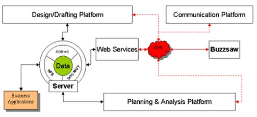
My next question was how to "map" this vision against the existing (and future) product offerings. To answer that question, Lang showed me a complex slide of arrows and boxes with the title "Future Interoperability." While it looked complex, it really wasn't. One key part of the vision is that ISD users need to be able to store their data in whatever form they like: in a database, in files (DWGs), in a document management system. That decision about how to store data may be made by the geospatial group, or perhaps more commonly, with input from an IT group or another part of the business (think assessor in local government or outage management group in an electric utility). That means that any and all of these data sources need to be accessible, ideally in the same way: that is, you shouldn't have to write different code to access the data in client software if it's in files or in a database. This "generic server" is at the heart of the future technology offering. The server provides data to business applications (like SAP) or to the Web as Web services. That opens doors to "communications" options (MapGuide), Web management options (Buzzsaw) and other clients. The server can also interact with the design/data creation side of the workflow, which will typically upload and download data (Autodesk Map, AutoCAD, Land Development Desktop). And, further along in the process, the server can interact with the analysis tools (Envision). The design and analysis parts can also tap into the Web services to pull in relevant data (Envision perhaps tapping into a Web Map Service, a server from any vendor that implements the Web Map Service specification). With that technology framework, the idea is to overlay specific solutions and even specific data models for different industries, something Autodesk has been working on informally, most notably in Europe of late. The other tangential topic we addressed was the role of the database as a key part of maintaining the intelligence of objects. Geospatial technology users, almost universally, have picked up on the concept of storing data in a database (Oracle, Access, PostGres, with or without some specialized software to manage the spatial aspects). Engineers are not there yet. Recall, for example, Bentley's attempt to jump into storing elements in the database, essentially making the design file obsolete. While the technology was built, Bentley executives explained in recent months that the industry simply wasn't ready for that change. Bradshaw noted that the business part of design and engineering work was built on paper drawings, that those were the ultimate deliverable. "Undoing" that way of thinking is not trivial and means making designers confident of the power of storing an entire model, say of a road segment, and only creating printed sheets when needed. The value is not in the sheets, but in the model. One corner of engineering is moving in that direction at Autodesk; the CAiCE technology Autodesk acquired last year is built on that premise.

AUTODESK SOLUTIONS: EMERGENCY RESPONSE The offerings, which depend heavily on third party partners, are what Sharp describes as "75% off the shelf." By that he suggests that much of the technology exists and is ready to go, the other 25% will be configured to suit the customer needs. That's the services aspect. The arrangement, going in with a platform, and one or more partners, allows Autodesk to offer a lower price than a fully customized system from a traditional integrator. Moreover, the solutions can leverage existing Autodesk technology and user data. Sharp likes to compare Autodesk's emergency response approach to Autodesk's strategy with AutoCAD for the design market (often described as providing 80% of the functionality for 20% of the price). He illustrated offerings from more than a dozen partners, which can be brought together or used alone to address specific security related needs. One was iMove, which I wrote about a few weeks ago. He demonstrated a very impressive MapGuide-based response "helper" tool from DESC Inc. that among other things could help predict how much water would be needed to put out a fire in a specific building, tease out viewsheds for counter-sniper activity, and calculate who should be evacuated in the case of a toxic release. It was 100% task driven; that is, it wasn't a "GIS" but a solution.

LETTERS "Thanks for your coverage of The Great Arc. I would like to bring to your notice a small correction. You have written 'To celebrate the 200th anniversary of the start of the Survey of India, several organizations have sponsored the Festival of the Great Arc. ' "Survey of India [the organization] is 236 years old and was established in year 1767. Great Arc Festival is the 200-year anniversary of the start of The Great Trigonometrical Survey (known as Great Arc, [an event]) by Survey of India." � Dan Cassidy wrote about my coverage of accessible maps last week. "You may well benefit from some assistive technologies and sensitivity training before again making such broad assumptions as to what an individual with or without a visual impairment may or may not see on a given visual display. Your State Department of Services for the Blind and Visually Impaired provides free technical support and training for yourself... Additionally - check out the free tools available to build more meaningful and productive spatial data products for the Web by way of Section 508 compliance. "By lumping all blind and visually impaired folks in one bucket - you missed the extended value of what Section 508 can do for all people - essentially extended meaningful metadata for all spatial information. If you feel that descriptive tabular data 'removes the geographic element' - don't read the book - only see the movie! "As a visually impaired person, I am a proficient user of assistive technology products such as screen enlargement, image enhancement and speech recognition software. My reduced visual acuity in no way reflects what you described below. With the example you gave - my first task was to re-project the display using a reverse color schema to rid the map of every shade of red, which is surprisingly a terrible color to view. While this was taking place I was able to highlight the tabular data and send that to both a screen magnifier and a voice synthesizer. This was all done without opting for the 'D' option format. Once choosing the 'D' format - my mental maps worked just fine and spatial continuity excelled�. Just because you lose or have diminished eyesight does not mean you have to lose your vision."

POINTS OF INTEREST Good Deed Department. Larry Oliver Jr., 15, has been photographing homes and businesses listed in the 1998 Historic Architectural Survey of the Warrenton Historical District in Virginia. To earn his Eagle Scout status, Oliver will create the framework for a GIS of the Historic District as a form of community service. The plan is to link the images into the town's GIS and make them available on the Web. Tracking Money. A traditional way of tracking packs of bills stolen from banks includes an exploding dye tool. It explodes and stains the money and those taking it. After a few too many bank robberies in O'ahu (Hawaii), bank officials are considering using GPS to track stolen cash. MapInfo Property Sold. Troy area public broadcaster WMHT Educational Telecommunications Inc. paid $3.66 million for the "old" MapInfo headquarters in Rensselaer Technology Park office and plans to move into it by late next year.
� Announcements ESRI has launched a website to commemorate the exploration of North America by Meriwether Lewis and William Clark's Corps of Discovery. UPS Aviation Technologies, based in Boston was in negotiations for a buyout by Garmin International Inc. An agreement was signed last week. Navigation Technologies joined the Symbian Platinum Program to support the emerging market for Symbian OS advanced mobile phones. Telcontar and TrafficCast announced a strategic partnership intended to accelerate the use of flow traffic information in navigation and other LBS applications. Under the agreement, Telcontar has used its Traffic Manager product to integrate TrafficCast's flow-based traffic feed with Telcontar's Drill Down Server (DDS) spatial software platform, and has become a TrafficCast data reseller. Applied Digital Solutions annual meeting didn't provide good news: Sales for VeriChip, a microchip that's implantable in humans, and Digital Angel, a GPS-based, wireless personal tracking device have been slow. The company may face delisting on the NASDAQ. A reverse split of stock might happen. Wherify has dropped the price of its GPS Locator for Kids to $199.99. Trimble reported second quarter revenues of approximately $138.1 million, versus approximately $123.3 million in the second quarter of 2002. Municipal Solutions Group, Inc. announced financial results for the second quarter and first half ended June 30, 2003 that included year-to-date sales growth of 29.8%. Second quarter 2003 revenue, at $1.1 million was unchanged from the same period last year.

� Contracts and Sales Full Circle Technologies announced that the town of Bedford, Massachusetts has signed a contract to Web-enable the town's GIS by using Full Circle's Web-based product, VectorEyes. Infotech Enterprises, an Indian GIS services company, announced that it has signed a long-term contract with Tele Atlas NV, The Netherlands, to provide map data conversion services. Avis Rent A Car System, Inc. and Motorola, Inc. announced a commercial contract that will make the "Avis Assist" phone-based navigation system available in up to fifty cities across the United States and Canada. Avis Assist, developed by Motorola, allows Avis customers to rent a Motorola phone with a location-based navigation service that literally 'talks them through' directions to a destination, broadcasting street names and maneuvers along the way. Intergraph Mapping and Geospatial Solutions, Shanghai Office, announced that Shanghai Telecom (SHT) selected Intergraph's G/Comms software as the enabling AM/FM/GIS core of its Enterprise Network Resources Management System. Merrick & Company announced a new $395,000 contract to deliver color digital orthophotography and updated planimetric features to be used in the City of Glendale's GIS. The Acacia Board has appointed location technology supplier Blue 8 to assist the Acacia Team by providing supplementary data management and technical skills in addition to those already deployed on the Acacia Pilot Projects. Acacia is a joint program being pursued in consultation with the Office of the Deputy Prime Minister (ODPM) by four government departments (Ordnance Survey, Land Registry, Registers of Scotland, and the Valuation Office Agency), the Local Government Information House and Royal Mail. The aim is to assist in the development of a properly integrated and maintained national infrastructure of definitive addresses, street names, non-addressable properties, land ownership and occupancy parcels, and other property information, all related to definitive mapping and building on existing initiatives. Vexcel Corporation, a company focusing on precision urban mapping products and services, has been commissioned by the U.S. Navy to design a system to provide fully automated extraction of 3D urban models from data collected by commercial satellites and other imaging devices. Australian telecommunications operator Telstra chose GE Network Solutions' Smallworld Network Inventory portfolio of products for its upgraded network planning and engineering system. In a multi-million dollar contract, Telstra will upgrade its incumbent Cable Plant Records (CPR) system to use the Physical Network Inventory product as a platform to plan, design, construct and manage its wireline network.

� Products WilsonMiller, Inc., a Florida-based planning, design and engineering firm, and Syncline, Inc., a Boston-based e-government solutions provider, announced the release of LandExplorer, a Web-based land evaluation tool for real estate, land development, and lending professionals. The tool allows lenders, underwriters, developers, appraisers, and insurers to search a vast database of property information with simple map-based tools. Maporama launched Maporama Partner Gateway 2003, a bridge that provides companies with a way to automatically update their address databases used for their location-centric applications with fast-changing data stored in their corporate databases. KDDI Corp.'s mobile phone service, au, is demoing a new phone, the model A3012CA, that according to an account at MobileMag.com allows users to take a still photo and then send it - along with a map of the place the picture was taken - to other people via e-mail. PCI Geomatics announced that the company's new "all-in-one" geomatics software solution, Geomatica 9, includes support for Supresoft's IMAGIS 3D GIS Visualization software. The product also supports the Advanced Synthetic Aperture Radar (ASAR) and the MEdium Resolution Imaging Spectrometer (MERIS) sensors. OziPhotoTool 1.6 has been released. OziPhotoTool combines the technology of a GPS receiver and a digital camera to automatically keep a record of where digital photos were taken. Version 1.6 fixes a few bugs, mostly associated with how different time zones are dealt, along with new features. Philcarto, a free software package to map geographical statistical data is available. Full documentation in English is now available. 3D Nature proudly unveiled Scene Express and NatureView Express. Scene Express is an add-on to World Construction Set 6 and Visual Nature Studio 2 that will allow users to export their projects for use in many other formats. Users will be able to render their final scenes in 3D Studio Max (other formats coming soon), create scenes for use in realtime applications like VRML, or even create physical solid models with Stereolithography technology. NatureView Express is a free realtime viewer created by 3D Nature that will allow users to explore their Scene Express files. Laser-Scan's Clarity is a new cartographic and data generalization product designed to help customers develop new digital products from existing data.

� Events � Hires and Appointments JumpStart GIS Inc., a Richmond, Virginia-based company providing parcel data conversion and maintenance services appointed Kinley Winchester as Data Services Manager. ImageLinks announced the appointment of Christopher P. Haakon to its Board of Directors. Mr. Haakon will help ImageLinks enhance its federal government-based software development and image products business.
ADVERTISE WITH US
CONTACT
SUBSCRIBE/UNSUBSCRIBE |