Points of Interest, Letters, Week in Review, Back Issues, Advertise, Contact, Subscribe/Unsubscribe
MICROSOFT PAIRS UP WITH AT&T; WIRELESS FOR HARDWARE AND SERVICES Steve Ballmer, CEO of Microsoft, outlined that the two organizations agree that there are three devices that will use wireless: phones, PDAs and notebook/Tablet PCs. The differences between a phone and a PDA are shrinking, causing Ballmer to quip that the difference is that a phone is used with one hand, and a PDA, with two. The two companies also realize that there may be several networks for wireless including the wireless LAN (802.11) to the next generation GSM/GPRS and on to other future ones. The partnership aims to support all three devices and these and future networks. The project has four key aspects: • The companies have developed and will distribute PocketPC and Smartphone based devices as well as solutions for Windows-powered laptops. AT&T will put out a voice activated PDA built on Microsoft Pocket PC Phone Edition later this year. • The devices will be easy to use and easy to deploy. For example, all handhelds will be preconfigured by corporate IT so that end users can simply turn them on and work. They'll allow the mobile user to plug into the corporate e-mail, calendar and other functions. • The devices will use location information from AT&T's network, along with MapPoint .NET, to provide what John Zeglis, chairman and CEO of AT&T Wireless calls "presence service." AT&T plans to be the first carrier to offer such services built on .NET. Zeglis used as examples the ability of two colleagues to find each other and set up a meeting or to find the nearest technician for a customer call. He boasted that the agreement will provide services that "no wired connection will ever be able to replicate." The solution is expected to be completely integrated with the instant messenger and Outlook clients on Pocket PCs and notebooks. • AT&T will use its channel and relationships with corporations to quickly and easily plug this solution into enterprises. Zeglis was quick to point out that "this is not a vague agreement…this thing is real" and noted that the two companies have been working together for months with customer trials already underway. The questions on the conference call held at 8: 15 am EST Wednesday were more interesting than the announcement. One caller asked the two executives to compare this relationship to that with Verizon. The new agreement, they replied, is about corporate workers and mobile data while the Verizon deal focuses on MSN Mobile and the consumer sector. The relationship is not exclusive. (Both companies are already connected to other partners.) The manufacturer for hardware will be announced soon, and Zeglis commented that there will be branding, but the devices "won't look like a race car." The PocketPC phone is expected in Q4 with the SmartPhone in 2003. A question about coverage prompted Zeglis to note that AT&T has GSM in 98%+ of its core area and is working to fill out other areas, mostly from recent acquisitions. The final question, from a representative of UnStrung-a rather irreverent website covering wireless technology-asked about how good the location technology is. An AT&T rep made it clear that it's the same single cell solution currently used in AT&T's Find Friend consumer service. He stated that in areas of high cell tower density, like New York City, a location may register within a few blocks of the true location. In Seattle, it might be up to 3/4 of a mile "off." In the future, he noted, AT&T would be looking at multiple tower triangulation, which should produce better results. Still, he argued, there are good applications for business even with a 1/4 mile error. I think this is a big step forward for location-based services (LBS) and the relationship has some promising features. First off, the focus on business is a good one. While consumers may be slow to pay for "frills" like LBS, companies, if convinced of its return, will not be. Furthermore, this newly-educated base will be key in moving the services into the consumer realm. Second, these are two large companies with an existing customer base of leading companies. This customer base should be easy to convince, as long as uptake is indeed as simple as has been suggested. Finally, if the LBS side of the agreement plays out as expected, there will be far less confusion about wireless services. Note that the wireless Web was not mentioned once in the press release, nor in the conference call. Still MapPoint .NET is a Web service. Shhh! Don't tell the end users they are using the wireless Web, they need not know!! One big question: is the location granularity indeed "good enough" for business, as was suggested? Certainly for 911 it's not good enough, but perhaps for "who is where?" questions it is. The other application that may fall down is point-to-point directions, another part of the LBS offerings. Microsoft and AT&T; Wireless to Unwire U.S. Corporations Microsoft, AT&T; Wireless Announce Strategic Alliance (AP)
INTERGRAPH ANNOUNCES SOLID SECOND QUARTER CEO Jim Taylor was pleased with the sixth consecutive profitable quarter. Though he sees things brightening in the economy, GIS and other government-focused business units are still finding reluctance as far as spending on information technologies. The press release notes that Bentley has decided not to file an amendment to its registration statement until the IPO market improves. Intergraph currently plans to sell some portion of its holdings in the initial public offering. Intergraph does not anticipate a verdict in its second lawsuit, now underway, before mid-September. Revenue and operating income for Intergraph Mapping and GIS (IMGS) dropped significantly from last quarter. The slowdown in government spending has extended sales cycles. The good news is that many sales during the quarter included both software and services. Z/I Imaging also had a tough quarter, showing decreased revenue and income from operations compared with last quarter. Still, the Digital Mapping Camera will ship in Q3, and TerraShare Enterprise software had $300,000 in sales to clients in the U.S. and abroad. The company does not see business going to competitors; money is simply not being spent at this time. In all, Intergraph is holding steady during tough times. Intergraph Reports Second Quarter 2002 Results
LANDXML APPROVED AS A STANDARD As I write, eight applications from six vendors implement LandXML, but LandXML.org can only validate that six of these can export LandXML according to the guidelines and specifications. The test for "round-trip," that is import and export, is not currently available. If you are scratching your head, let's see if I can help explain. I know a bit about specifications since my consulting company provides services to the Open GIS Consortium, a standards organization. First off, what does it mean to say that LandXML has been approved? In essence it means the organization put together to develop LandXML, LandXML.org, which describes itself as the Land Development and Transportation Industry Consortium, has approved the LandXML specification. It does not mean that some objective set of reviewers approved it. It does not mean that other standards' organizations, such as the International Standards Organization (ISO) or the American National Standards Institute (ANSI) have approved it. Instead-and this is important-competitors (180 Land Development and Transportation Industry professionals from 86 organizations) who set out to develop the standard all agree on it. Second, what are the different levels of support for LandXML in software? LandXML is a specification. Basically, anyone who writes software can use the specification to create software that reads or writes this "format" called LandXML. LandXML.org has a process to see if, in fact, the software writes LandXML correctly. The process requires a submitter to provide a sample exported LandXML file. That file is reviewed, and if it passes muster, the software product is listed on the LandXML website and the LandXML file provided is posted as a sample. In the future, there will be a process to test both reading and writing LandXML. Those products that pass will be able to include a LandXML 1.0 logo on the box. I want to point out something I've learned from experience: testing only shows that the product developers "followed the rules" for writing LandXML. It doesn't tell whether the software itself "got the right answer." Finally, how will we know if this is a useful standard? Standards are useless unless more than one software package supports them. LandXML has a solid start with some big name companies already producing products that support it. These include Autodesk, Bentley, Trimble and Eagle Point. That said, one of the great things about standards is that they can bring smaller vendors onto a sort of "equal footing" if they too, support the standard. I expect that LandXML will "trickle" down to the smaller vendors. LandXML Accepted as a Standard
LETTERS • Dave Murray wrote to highlight that ESRI's ArcReader should be compared to ArcExplorer. He, like other readers, was concerned about the $2500 price for the ArcPublisher extension and hoped ESRI might reconsider that pricing policy. "I have to agree with you regarding the usefulness of ArcReader. I base my comparison on the functionality of ArcExplorer. The geocoding option is not available or I couldn't find it. The biggest problem with it in my opinion is that it requires ArcPublisher that is quite expensive. It would be interesting to see what the adoption rate for this software is." • Thomas Misek, Manager, Geographic Information Systems TGS-NOPEC Geophysical Company was working out how to make map "pictures" available without sending along the data, more like Adobe Acrobat. He came up with two solutions: "It is possible to use ArcMap and export any and all spatial datasets as a geo-referenced TIFF image without attributes…The Export Map window Options button will allow increasing the DPI to reduce the 'jaggies' in the image. The TIFF file is automatically georeferenced, even without checking on the 'Create World File' box…Since this is an image file, I suggest building pyramids for faster drawing in AreReader later. "The second option would be to edit the feature dataset and remove some or all of the attributes for that data. Then use the edited dataset for the ArcReader file."
• I'm pleased to learn that I'm not the only one having trouble figuring out Microsoft's .NET. The New York Times (and others) this week explained that Bill Gates himself admitted that the company is doing fine putting the technology together, but has work to do explaining its mission to the organizations that might use it. • The GeoCommunity has introduced the GeoBids Notification Service. Subscribers are sent daily e-mails (text only) detailing RFPs, bids, tenders, etc. The cost is noted as "less than $1 per day." The price? $89.95 for 90 days. The free Web-based service now provides only RFP titles; the full documents are only available via subscription. • Intergraph has jumped on the educational grants bandwagon, offering site licenses of GeoMedia Professional to K-12 educational institutions and GeoMedia Professional, GeoMedia Web Map Professional and IntelliWhere OnDemand and IntelliWhere Location Server to community colleges, technical schools and four year colleges. The grants are valued at more than $6 million dollars. Instead of providing lesson plans, Intergraph is asking that the institutions of higher learning provide a preliminary and later, a detailed lesson plan. The plans will be entered into Intergraph's international GeoMedia Best Practices Awards contest. • Electric Power Development Co is one of three companies in Japan that will market a new type of geographic information system in which day-to-day changes in cityscapes and streets can be recorded. The innovation, according to an article in the Japan Times Online, allows users to update only those portions of the electronic map in which changes have taken place. • Thales Navigation is holding an essay contest to pick a representative to compete in a road rally outside Las Vegas in December. Using GPS, luck, clues, and a poker hand the representative will compete with other over a 250 mile course.
� Announcements Webraska is providing the core geospatial and mapping technologies for the BIKE TransAlp Challenge 2002 (July 20-27, 2002). The geospatial platform is used in the m.traction Resource Control solution, the Mobile Tracking Service offered by Siemens mobile, one of the sponsors of the event. The particular position of the racer can be pinpointed via satellite at regular intervals with a precision of 10 meters, and relayed to a central server. From this server, the location of the teams can be displayed on a zoomable, scalable map via a web interface. ESRI honored the seventh grade GIS class of Jenifer Junior High School, Lewiston, Idaho, at the opening session of its 22nd Annual International User Conference in San Diego on July 8. Two students, Ian Coleman and Nate Ebel, and their instructor, Steve Branting, spoke to the conference audience of more than 11,000 GIS professionals about their project. The Jenifer GIS Team is part of the Lewis and Clark Rediscovery Project, a Technology Innovation Challenge Grant program funded by the U.S. Department of Education. As part of their project, the students studied the Normal Hill Cemetery, which opened in 1888. DMTI Spatial provided its detailed map data, CanMap Streetfiles to aid the G8 Summit Security Task Force with planning and security at this year's G8 Summit held in June in Kananaskis, Alberta. InfoTech Enterprises has reported an increase of 65% in its net profits in Q1. It says that the growth has been achieved mainly through increasing efficiencies and optimum utilization of resources. The GIS focussed company has also registered 40% growth in total income for the first quarter at Rs 29.6 crore as compared to Rs 21.12 crore for the same quarter recorded last year.One of the largest energy distributors in Australia, TXU Networks, has implemented a major new outage and service order management system using GE Network Solutions software products and services in just five months. The release notes that this is "near record time." The Geospatial Information & Technology Association (GITA) is pleased to announce that The National Educational Telecommunications Association (NETA), Columbia, SC, has agreed to provide a satellite feed of The World in a Box television program to its public broadcasting licensees in August 2002. You'll need to check with local PBS affiliates to see if it will be shown in your geography. Avenza is pleased to announce the winners of the 2002 MAPublisher Map Competition - a competition that showcases the quality and diversity of maps that can be produced with MAPublisher. Details of each map, the associated images and notable entries, can be found on the company's website. IntelData, Inc. and PlanGraphics, Inc. of Frankfort, KY have collaborated to develop and implement the Voyager Integrated Library System (ILS) Graphical GeoSearch Application for The National Imagery and Mapping Agency's (NIMA) Research Division. The Graphical GeoSearch (GGS) application incorporates features that give members of the intelligence community the ability to more rapidly and accurately search for information about geospatial products. A visit by some of Saudi Arabia's top mapping experts to Ordnance Survey's head office in Southampton is the latest stage of efforts by Britain's national mapping agency to share expertise and exchange information with similar organizations from across the globe. Laser-Scan has received a SMART grant to develop advanced text placement functionality in its products. SMART (Small Firms Merit Award for Research and Technology) Awards are UK Government grants, given to establish the feasibility of innovations and inventions and to help the development of products through to the pre-production state. The new capability is to be developed within the company's Gothic Object-Oriented (OO) Java Application Development Environment. The State of Louisiana is implementing Watch Systems' TaxWatch, a new Internet-based tax code calculation system, that will be deployed in all State Motor Vehicle Offices. The system is needed because in Louisiana many municipalities have separate tax rates for their jurisdiction and the State has special tax districts that do not follow traditional boundaries. Maporama and I-Media, provider of electronic communication in France, announced a strategic partnership to develop an ASP-based, multi-channel direct geo-marketing solution. The solution involves providing personalized messages to potential customers based on addresses. The City of Prescott's Emergency Operations Center in Arizona used Earth Resource Mapping's image processing software, ER Mapper, in managing and monitoring raging fires that destroyed the Prescott National Forest and surrounding areas at rapid speeds. MapInfo announced a global partnership with Intrado Inc. that will allow wireless carriers in North America and Europe to target new revenue opportunities by bringing to market a broad range of cost-effective, customized, location services for the mobile Internet. Leveraging their expertise in location-based solutions, services and hosting capabilities, the companies will combine the strengths of MapInfo's miAwareTM platform, the premier location-based services solution, with Intrado's location technologies and services. Intrado has experience in 911 applications. � Contracts and Sales. Intermap Technologies announced today an agreement with The Environment Agency of England and Wales to use its NEXTMap Britain dataset of highly accurate digital maps covering England and Wales. The digital maps will be delivered as Digital Terrain Models (DTMs), sourced from Intermap's NEXTMap Britain Program. The Environment Agency intends to use the DTM to support the Agency's Flood Mapping Program, a key component of recently announced advances on flood defense. The State of South Dakota has selected ESRI to supply a comprehensive statewide K-12 software license.
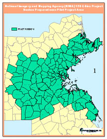
The Commonwealth of Massachusetts has contracted with Applied Geographics, Inc. (AGI) to provide geographic database design and support services for the Boston Preparedness Pilot Project. Funding and project participation was provided through the Executive Office of Administration & Finance (EOAF) and the Executive Office of Environmental Affairs (EOEA) MassGIS program and a variety of Federal agencies. The Pilot was initiated in response to the National Imagery and Mapping Agency (NIMA) 120 Cities Project, an effort to engage state and local agencies to gather and maintain important geospatial data in support of homeland defense and emergency preparedness. Bentley Systems, Incorporated announced that it has completed the acquisition of Rebis. Bentley's initial minority interest in Rebis was purchased in January this year. With this acquisition, Bentley's plant design applications now support both Bentley's MicroStation and the AutoCAD software platform from Autodesk, Inc. Rebis' annual revenues are approximately $16MM. International Business Machines Corp. (IBM) has signed a deal with Honda Motor Corp. that will provide voice activated telematics on the 2003 Honda Accord for sale later this year. The voice recognition software is based on IBM's ViaVoice product. TeleCommunication Systems, Inc. (TCS) developer of wireless location and messaging software, announced that in the first quarter of 2002 it was awarded a contract to provide location-based software products and services to Hutchison 3G UK Limited. This agreement for location software products and services represents one of the largest in the industry, according to a company news release. The TCS Xypoint Location Platform will initially be deployed in the UK and then in other countries where Hutchison Whampoa has 3G interests. � Products The CEDRA Corporation is shipping its CEDRA-AVparcel software for ArcGIS software. CEDRA-AVparcel for ArcGIS offers ArcMap users the ability to perform COGO and parcel maintenance applications directly from within ArcMap. Safe Software Inc. announced the immediate availability of GML 2 support across its entire product line. Safe Software used its configurable XML translation engine to build the GML 2 reader and writer, a feature that allows users to quickly and easily add support for any XML-based data format. Thompson Associates, has unveiled Smart Site Solutions, a suite of affordably priced site-selection packages for virtually any retail or consumer services company. The packages are now shipping. Manifold System Service Pack 2 (SP2) is now available. SP2 includes 120 listed improvements and is downloadable here. A previous Manifold 5.0 license is required for it to run. Ordnance Survey's 1:50 000 Scale Colour Raster data is now availble. The files are an exact digital replica of the latest version of the national mapping agency's pink-covered paper OS Landranger Maps. Recent improvements to the series have made the mapping even clearer and easier to use.
HNIT-Baltic GeoInfoServisas, distributor of ESRI's GIS software in Lithuania, announces the release of Cellular Expert 2.0, the latest version of its popular radio network planning software. Building radio frequency engineering tools on top of ESRI's ArcGIS 8.x software makes Cellular Expert 2.0 a powerful industry solution.
Wherify Wireless' GPS Personal Locator for Children became available for order Wednesday. The watch-sized bracelet costs $399 plus a monthly service charge. I tend to agree with a Family Circle contributor who noted that having children "police their own behavior is the key to keeping them safe." NovAtel Inc., a GPS manufacturer, introduced today the ProPak-LB. This new positioning engine coupled with the GPS-600-LB antenna delivers decimeter-level accuracy autonomously with subscription to OmniSTAR's new HP (High Performance) satellite service. NovAtel's ProPak-LB is the first OmniSTARHP enabled GPS engine on the market. Using the system, there is no need for the additional cost or inconvenience of a user base station and radio link. Claritas Inc. announced that it has partnered with Microsoft to expand its iXPRESS product line with the introduction of iXPRESS for MapPoint, Microsoft's business mapping software. Mapping Analytics announced the release of MapBridge, an Add-In for Microsoft MapPoint that provides demographic data retrieval and analysis functionality. Powered by SRC's Allocate engine, MapBridge allows users to quickly and easily import demographic data into MapPoint and generate presentation quality output. RADARSAT International (RSI) and the Danish Meteorological Institute (DMI) have signed a contract worth USD 935,000 for the near-real time processing and delivery of RADARSAT-1 and ENVISAT data. The contract runs until December 31, 2003 and ensures that DMI will receive time-sensitive imagery for creating ice charts and reports. This critical information is delivered from DMI to the bridge of ships navigating the Greenland Sea, to ensure their safe passage. Laurel Hill GIS, Inc. announced that GeoData Sentry, an automated quality control/quality assurance (QA/QC) off-the-shelf software product for ArcGISenterprise geodatabases, is planned for release later this summer. � Hires and Appointments Andre M. Boisvert, Sagent's chairman, will assume the chief executive role on an interim basis. Boisvert, former president of SAS Institute, and a software technology industry veteran, brings more than 25 years' experience in the business intelligence sector to Sagent. Ben C. Barnes has stepped down as Sagent's chief executive officer. There are several other management changes, too. Dakota Worldwide announced today that it has named John Kugele as Sr. Vice President of Strategic Planning for Independent Operations and Managing Director of its Southeastern operations. The company also named John Kugele as Sr. Vice President of Strategic Planning for Independent Operations and Managing Director of its Southeastern operations. Kugele joins Dakota Worldwide from Piggly Wiggly Company where he had served as Senior Vice President, Research and Franchise Administration. Luciad, developer of open geographical software solutions, announced the appointment of Stijn Bijnens, CEO of Ubizen, as chairman of Luciad's board of directors. Space Imaging announced the appointment of Jim Youker to director of Military Programs and Dennis Jones to director of Intelligence & National Security Programs. Both are moving from positions within the company. Thales Navigation announced the appointments of Tom Capizzi as vice president of worldwide human resources, and Elissa Wellikson as vice president and general counsel.
ADVERTISE WITH US
CONTACT
SUBSCRIBE/UNSUBSCRIBE |