Letters, Points of Interest, Week in Review (Announcements, Contracts, Products, Events, Education and Training, Hires) Back Issues, Advertise, Contact, Subscribe/Unsubscribe If, for some reason you cannot read this document, visit: http://www.gismonitor.com/news/newsletter/archive/090403.php
ELEVEN-DIGIT ZIP CODES I found most of the information concerning 11-digit ZIP codes on websites belonging to commercial mailing companies. Bar coding basically converts a street or mailing address into a series of short black bars or stripes. Post office computer scanners read and sort bar coded mail very quickly. (Hand-written mail is either manually sorted or the addresses are keyed into a computer [new technology for that here] and bar coded at the post office.) An article from the University of Michigan notes that a postal employee can sort 800 to 1,000 pieces per hour while machines can sort more than 36,000.
So why the extra two digits? In short, geography. This 11-digit code, called the Delivery Point Code (DCP), pins down the address location even further than ZIP+4. There are 125 million delivery points in the United States, according to one website. The two extra digits are typically the last two digits of a residential address, but might also be from a suite number or post office box. (Five, nine and 11-digit barcodes are at right.) The Barcode Island website gives this example: "�if your zip code is '80122-2014' and your street address is '3801 E. Arapahoe Road,' your Delivery Point Code would be 80122-2014-01. The final '01' is taken from the last two digits of the 3801 street address." Special software is available that takes addresses that are ZIP+4 Coding Accuracy Support System (CASS) Certified (meaning they conform to USPS standards), determines Delivery Point Codes and writes them in bar code form. DPCs were first tested in 1991. One benefit to the post office is that the mail can be sorted in "walk order" for carriers, saving each carrier substantial time. Not everyone is happy about DPCs. I found this rant, Delivery Point Barcoding ... AARGH!, arguing it doesn't really help and is not really practical. What impact will the 11-digit code have on geocoding? For now, it seems to be used exclusively in bar codes on mail; I see no references to its application to personal mail or the ways in which we provide our addresses to friends and businesses. For that reason it's hard to imagine the necessity of gathering and storing DPCs in say, corporate databases. The technology is certainly available that will allow such addresses - either in barcode or numerical form - to be entered into a database, but, should there be demand for DPCs, I am certain that those in geocoding technologies will be able to geocode them. After all, dealing with points should be far more straightforward than dealing with address ranges.

A SMARTER TALKING HOUSE? I'd read about Smarter Agent a few weeks ago, but didn't make the connection to Talking Houses until I read an article by Tom Kelly. He suggests that Smarter Agent, a technology from a company of the same name in Philadelphia, is the next iteration of the idea, enhanced by GPS, cell phones and other wireless devices. While today's users receive Multiple Listing Service (MLS) information, I suspect future offerings may include interior pictures and other goodies. While details about pricing are not available on the website (the wireless tools are in beta), Kelly notes that a price of $5 month for end-users is likely. Much of the cost will be paid by local exclusive distributors, likely realtors, who may well use the service to advertise on the system, too. Is this a killer location-based service? It's interesting question. I'd be interested to know how the Talking House company is doing. Does the company make money? Kelly notes that the service is particularly popular in rural areas, where houses are very far apart and far from agents. For users, Talking Houses require only a car radio or AM-Walkman, and no fee is charged to hear the information. The seller (or perhaps the agent) pays for the Talking House system and basically records a tape about the house's selling points. That makes for a nice personal tour, but remember, it's coming from someone who is trying to sell the house. Smarter Agent's offering requires the buyer to have a fairly advanced cell phone or PDA (at the least, one that can surf the Web wirelessly, at most, one with GPS). And, of course there's the wireless service contract and the Smarter Agent service costs to add on. That presents a few more barriers to entry than the Talking House. The MLS data consists of numbers and descriptions, but the seller, so far as I can tell, doesn't do anything to make the data available, except pay to put it on MLS. Of course, that data is available elsewhere - from a realtor or online - for free. Smarter Agent's website uses ObjextFX technology for its mapping and has a typical set of tools for searching for property in the Philadelphia area (other areas are coming soon). A free registration provides access to MLS listings. As I understand it, that information is available via a non-GPS wireless device, just as it's accessed via a wired browser from the Internet. A GPS-enabled device will find properties for sale nearby. (The company claims a patent on the wireless GPS search.) The website also provides a hint as to an incentive for buyers to use the service - depending on the price of a purchased property, buyers may receive a portion of the broker's commission, at least in states that allow that type of thing.

Last week I noted: "A bit outside the GIS world, one smaller CAD company, International Microcomputer Software, Inc. also known as IMSI, based in Novato, California (that's just down the road from San Rafael, the location of Autodesk's headquarters) purchased CADKEY, based outside Boston." I jumped the gun, as Ralph Grabowski points out: "Umm... not yet. They hope to complete the purchase in October, but are aware that another CAD vendor could easily pick up CADKEY by outbidding IMSI." A reader, and perhaps others, wanted to know how they might get in on Autodesk's drawing for a free Autodesk University registration if they'd registered before reading the announcement. Autodesk provided this answer. "If you have already registered for this year's Autodesk University, you may still have the opportunity to win the complimentary pass valued at $1245.00. Simply email us at [email protected] with the promotion code (GIS2003), first name and last name. Your registration will then be entered into the drawing." If you've not registered yet and what to get in on the drawing, see details in last week's issue.

LETTERS � A reader wrote to quiz me on the company that "has been creating maps longer than any other company in the United States." I guessed Sanborn, based on work done at Penn State in Deryck Holdsworth's class, which is what the reader had in mind. That company was founded in 1866. The reader asks if anyone knows of companies that have been making maps longer. If you do, drop me an e-mail.

POINTS OF INTEREST Caught by the Loot. In Janesville, Wisconsin a not-too-technically-savvy crook made off with a brick-sized GPS unit that is designed to keep tabs on people serving home detention. The brick stays put, and the detainee wears a small device that "tethers" them to the brick. The would-be thief was caught soon after the device signaled that it was taken outside the detainee's restricted area. By the time the detainee phoned police to report it missing, police had both the device and the thief in custody. New Technology for Nunavut. A high school teacher from Brandon, Alberta is traveling to Cambridge Bay in Nunavut (one of Canada's territories and home to 29,000) to teach GIS. The trip to a high school there is part of the Royal Canadian Geographic Society's Fraser Lectureship in Northern Studies and is in collaboration with the Nunavut Planning Commission and ESRI-Canada. Says a spokesperson at the Nunavut Planning Commission: students who graduate with a diploma or degree in GIS are virtually guaranteed a job at Nunavut Tunngavik Incorporated, which owns and manages land. Would You Use This Service? Telecommunications Systems bought XYPoint some time ago and is rolling out its new merged solution for directions. I say merged since it uses voice and SMS to deliver location-based service. Here's how it works: you dial a phone number to select which service you want (find a bank, a Starbucks, pizza place, etc.). A voice on the other end says that a text message will soon be delivered with directions, and you are off. The phone call is required since E-911 locating is linked to voice calls only. The SMS return helps carriers make more money with the several cent payment for receiving SMS messages. Marketing folks at TCS note that since you won't have to sign up, users should be more likely to try this system than other LBS offerings. They also offer that text directions stored in the phone are far better than verbal directions stored in one's head.
Addresses for Australia. By the end of the year the first authoritative address database for Australia will be delivered. A three-year joint venture by the nation's state, territory and federal governments should produce a definitive list with every single address. In the end, the Public Sector Mapping Agency (PSMA) will be single keeper of address data for the country. While the data will be used for mail delivery and emergency services, private companies will also have access to the lists for well, junk mail. LogicaCMG, a company recently involved with developing the state of Victoria's land management system, is the prime contractor for merging the databases. Geometry Pty Ltd of Tasmania is developing the database and display software. Mapping Incidents in Prison. Northampton County and Philadelphia, Pennsylvania corrections staff will soon be using a mapping program developed by Temple University through a federal grant. The system is an offshoot of "School Cop" a program used to track bullying in high schools. Not so much a tracking program, as it is a GIS, staff members key in location and other information about incidents and the software then helps to track patterns. In Seattle, the pilot program for the still unnamed system is nearly complete, and the two Pennsylvania facilities will be the next to use it. Plagiarism on the Rise. A study by Donald McCabe, a management professor at Rutgers University, indicates (New York Times, registration required) that plagiarism involving the Internet is on the rise. MCCabe's study involved students at 23 colleges. Thirty-eight percent of respondents admitted to such violations and about half considered such acts minor or trivial. Says Kathleen Deignan, Princeton's dean of undergraduate students "We live in a world where a lot of this is negotiable. Academic institutions need to say, `This is not negotiable.'" GIS Monitor has been subject to plagiarism both in print and on the Internet in the past year. This is not negotiable. The Selling of GIS Data. Will County, Illinois finance committee members will pay Maximus Inc. a consulting fee of $10,700 to prepare a report on the GIS pricing. The county is exploring ways to recoup its $3 million investment. I guess this discussion isn't as far along as I'd expected. What does this say for NSDI and related matters? Quote of the Week. "It's really the wave of the future," says Waltham, Massachusetts Transportation Director Frank Ching about the new GIS for the city. In related news, the city is looking for a GIS coordinator. The mayor has asked for funding for the position, which has a $58,428 annual starting salary.
� Announcements Intergraph Mapping and Geospatial Solutions announced that a GeoMedia education grant, valued at more than $1.1 million, has been presented to Team GeoMedia Registered Research Laboratory member George Mason University (GMU) in Washington, D.C. for the institution's Earth Systems and GeoInformation Sciences Program. Following a successful pilot program with World Wildlife Fund Canada (WWF-Canada), Markham-based DMTI Spatial launched its new "Charity Program" called GRACE, which stands for Geospatial Resources Assisting Charitable Enterprises. As part of GRACE, not-for-profit/charity organizations will receive an enterprise-wide license to access a suite of over 11 DMTI Spatial products, including CanMap Streetfiles, CanMap RouteLogistics, the Enhanced Postal Code file for Canada, the GeoPinpoint Suite, CanMap Rail, and the 30 Metre Digital Elevation Model for Canada. Stone Analytics, a provider of embeddable predictive analytics, announced that Mapping Analytics will integrate Decision Science for Marketing into its next generation of GIS products.

� Contracts and Sales The Houston Airport System (HAS) recently awarded a $2 million contract to a group of companies for the development of an enterprise GIS framework using ESRI software. The Village of Briarcliff Manor, New York, has contracted James W. Sewall Company to map the Village's infrastructure assets and to design a geodatabase that integrates the mapping with Westchester County's existing GIS landbase. Kivera announced that AAA Mid-Atlantic has purchased Kivera's Location Engine to automate the dispatch of tow trucks for roadside assistance.

� Products GeoMatrix Toolkit version 1.4.1 is now available for free 30-day evaluation. The GeoMatrix Toolkit, by GeoFusion Inc., is a C++ Software Development Kit (SDK) that provides an object-oriented Application Programmer's Interface (API) enabling software developers to build high-performance, interactive full-globe digital Earth and planetary-based applications. PCI Geomatics announced the release of Geomatica 9 for UNIX platforms.
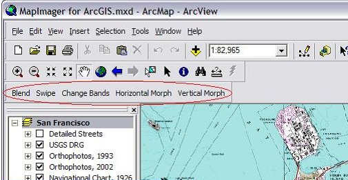
Telemorphic, Inc. announced MapImager, an extension to ESRI's ArcGIS software. MapImager adds powerful, affordable, and easy-to-use geographic imaging and visualization capabilities to the ArcGIS desktop. Idan Computers Ltd., a software company that develops CAD, image analysis, and geospatial applications, announced the worldwide distribution of its Oblivision software. Oblivision is a unique image analysis tool designed to combine the accuracy of orthophotos (top-down images) with the rich detail of oblique (inclined) photos. Maporama, a leading Enterprise Location-Centric Services (ELS) Application Service Provider, announced the immediate availability of detailed door-to-door itineraries for Taiwan.

� Events A Homeland Defense Management Seminar titled "GIS Moves to the Front Office" (Word Doc file) will be held Thursday, October 23, 2003 in Arlington, Virginia. Ordnance Survey announced a nationwide series of technical seminars designed to help customers get the most out of OS MasterMap, its latest generation of highly detailed and intelligent digital map data. They run in various locations from September through November. � Education and Training � Hires and Appointments Haestad Methods, a water resources software company, announced the formation of a Sydney-based office following the opening of similar operations in China and India. Groupe Hauts-Monts, a Qu�bec City-based company, will now operate its three companies that specialize in geomatics solutions, specifically Hauts-Monts inc., G�omatique G.P.L. Consultants inc., and Geomat International inc., under the name Groupe Alta.
ADVERTISE WITH US
CONTACT
SUBSCRIBE/UNSUBSCRIBE |