Letters, Points of Interest, Kudos and Conundrums, Week in Review (Announcements, Contracts, Products, Events, Training, Hires) Back Issues, Advertise, Contact, Subscribe/Unsubscribe If, for some reason you cannot read this document, visit: http://www.gismonitor.com/news/newsletter/archive/091504.php
Adena

Reader John and others on Web are noting legislation that could place specific U.S. government procured commercial satellite imagery outside the control of the Freedom of Information Act (FOIA). The legislation (the National Defense Authorization Act for Fiscal Year 2005) has already been approved in the Senate (back in June of this year) and will be considered in a House-Senate conference committee this month. Secrecy News (a publication of the Federation of American Scientists' Project on Government Secrecy) notes that the law would include not just the imagery itself, but products derived from it. Further, the law would preempt any state laws regarding open distribution of imagery, like for example Florida's famous "sunshine" law, should the state gain access to data in this category. After reading the document in question, and concerned responses, I found myself confused. I was lucky enough to speak with a consultant to the Department of Defense on legislative matters who clarified some of the issues. There is work going on now to change the language to make the section more clear, before it heads to conference committee. The first concern regards which data is affected. It's not all remote sensing data, as some have understood, but a special subset, one that doesn't exist yet. The proposed exemption applies only to data that's available exclusively to the U.S. government "and its affiliated users" (allies). The confusion here stems from language in the document that refers to data restricted per the Land Remote Sensing Policy Act of 1992, which focuses on the continuity of the Landsat program. The restrictions to which the document refers are in fact embedded in the licenses that commercial remote sensing companies receive from the government, what are referred to as a two-tier license agreements. Lower tier data is available commercially, and includes the 1 and .62 meter satellite data now available. Upper tier data is restricted to purchase by the U.S. government and government-approved users. Which data falls into which category is determined on a case by case basis. Currently, several licenses have been granted for sensors that will yield upper tier data, though none are in orbit. They include technologies to capture � meter imagery, some hyperspectral products and some synthetic aperture radar products. It's the data from those sensors that are to be excluded from FOIA under the section of the Authorization Act. So, basically, data regular citizens can't buy now, and won't be able to buy even when the birds are in the sky, will also not be accessible via FOIA. The Department of Defense doesn't want these types of data in the hands of anyone who might use it against us. That's why the licenses for the sensors were written as they were. Removing that data from access via FOIA strengthens the government's hold on it and at the same time, continues to make it possible to share the data with U.S. government agencies, state and local government and allies. Another way to restrict access would be to classify the data, however that makes many of these sharing scenarios much more complicated. Another option, of course, is to simply prevent the government from buying such data at all. The commercial satellite imagery industry probably would be against that, as would many others. The bottom line then is this: � The restriction to FOIA only applies to data that will not be directly accessible to commercial interests or the public. Responses Barbara Cochran of the Radio-Television News Directors Association (RTNDA), an advocate for news media use of commercial satellite imagery, spoke out on the impact of such a measure on the media in a letter to the House Armed Services Committee. "In essence, this new FOIA exemption would result in taxpayer dollars being used to preclude the media from adequately informing the public about matters of critical importance that in no way implicate the national security." The RTNDA letter goes on to suggest that imagery that does in fact threaten the nation should be classified, thus making it exempt under FOIA. The America Library Association (ALA) petitioned the committee chairman to drop the exemption. Its letter was to be delivered last Friday and many media organizations and FOIA related organizations signed on in support. The text questions the language of the report in addition to suggesting the government, as it were, "eat its own dog food" by following the recommendations of the recent Rand study.

25% of respondents tried to find data there. While this seems dire, it may not be so bad. Note, for example, that Geospatial One-Stop is the name of the initiative. The portal, where metadata is held, is referred to as "geodata.gov." Perhaps those who've never heard of the initiative know of the website? The nearly 30% of those who tried to find data and failed may simply reflect that there's not a lot of data posted there yet, and that only recently has the portal begun harvesting metadata from clearinghouses and other websites that "sign on" for automatic harvesting. It might be interesting to ask about other portals/resources used to find data. Geodata.gov has 236 backlinks (that is, websites that link to it, according to Google). Starting the Hunt, a resource from University of Arkansas Libraries and the Center For Advanced Spatial Technologies (CAST) has 91. ESRI's Geography Network has 1510.
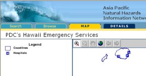
The model for Geospatial One-Stop follows the Geography Network and is becoming a familiar look and feel for portals. ESRI is packaging the portal code and services in its GIS Portal Toolkit. This week I read about the Asia Pacific Natural Hazards Information Network (APNHIN), left, hosted by the Pacific Disaster Center, which is built on the same model.
Attend GITA�s GIS for Oil & Gas Conference and explore how geospatial information can help you meet pipeline integrity and regulatory compliance challenges while maximizing your operations.
� One reader, "not a GIS analyst" but someone who "implements GIS technology as a contractor/consultant in tandem with facilities management solutions" found my comment disturbing, perhaps because he felt I was discouraging civil engineers from exploring GIS: "�this does not mean that civil engineers should not explore the possibility of using GIS and integrating it in key places in project development�.Perhaps ESRI can, to some extent, better explain what I mean" in an article about some engineering tools built on ArcGIS from CEDRA. "�the potential for this technological merging (which I also share in to some extent) has not even scratched the surface of what can be accomplished if technological prejudices/ignorance is eliminated and key players are encouraged to work together to produce mutually beneficial business solutions." � Another reader offered some concrete examples. Kevin Briggs is a civil engineer with the city of San Jose whose staff includes GIS professionals. (I met Kevin over breakfast at Intergraph's Geospatial World a few years ago.) He explained how comparing old data with new gave insight into the past. "A query comparing contour elevations [from old maps] to top of manhole elevations in our database would provide a better understanding of the origins of the elevation data in our database." Data from the GIS database on sanitary sewer, storm drain and water are shared with consultant firms. "The size of pipes, elevations, valves, .... data in our database are all critical to the creation of a good hydraulic model that can replicate the operation of the existing systems." He noted the GIS' use in GASB34 requirements. "We've used GIS to determine how much pipe, how many valves, how many square feet of roadways, sidewalks." He noted its use for locating "backflow preventers on � sewer drain pipes" by "comparing elevations of the street to elevations at building footprints." And finally, he noted its use in estimating cut and fill volumes. The editor responds: I did not mean to suggest that civil engineers (or any other profession) should not explore GIS. I apologize if that was how my question was understood.

Points of Interest Quote of the Week. "Too many GIS systems on sale appear to require a Ph.D. in advanced IT to use. Marketers should only look to purchase GIS software that requires no more than half a day's training, allows data to be exported and imported flexibly in many formats, and allows marketers to undertake bespoke data analysis, profiling and mapping from their desktops." That statement comes from the Preference Service managing director Thomas Adalbert commenting on what those using GIS in business should seek in a solution. GPS Tracker Claims Innocence. A man accused of using a Nextel phone to track his ex-girlfriend has pleaded innocent. His modified phone, which turns itself on when it senses motion, was provided by a new vendor of tracking technology in California, where the tracking occurred. There is a law against tracking another person in the state. However, since the device tracked a car, it's not really clear what the legal implications are. More interesting, perhaps is the technology of "auto-on/auto-off." Working that way the phone and GPS batteries would last far longer than in an always on model. Predicting Fast Food Needs. Why not put rooftop cameras on your fast food restaurant? With simple technology they can count cars heading into the parking lot. In time, they might be able to distinguish minivans from one person vehicles. That data can help predict how many burgers to put on the grill. It could get worse: knowing what type of car a visitor drives could help predict if its time to make more salads or triple bacon cheese burgers. The beginnings of this technology, from a company called HyperActive Technologies are already in place in Pittsburgh, PA. One store, with two years of experience with the system claims waste has been cut in half and drive-through lines are served 20 to 40 seconds faster. Kivera Acquired. TeleCommunication Systems, Inc. a provider of E911 solutions, signed a definitive agreement to acquire substantially all of the assets of Kivera, Inc. That's one of the first "we provide the location" type companies that's bought a "we know what to do with the location information" company. AAA uses Kivera technology for its member only online "TripTiks." TeleCommunication Systems has about 700 employees, Kivera just 27. TCS bought another company eight months ago and dismantled it. The best discussion of how the two companies fit together that I found is in eWeek.
Kudos and Conundrums Kudos (concepts we applaud) Tiny Borg Satellites. Ok, they are not integrated like the Borg, but tiny satellites seem to be in our future. A conference on "CubeSats" was held last month in Utah. Universities and private companies worldwide (mostly from the U.S.) are exploring the possibilities of using a 4-inch, 2 pounds pile of off the shelf equipment for a variety of commercial and scientific uses. A few are already in space and someday remote sensing may be as simple as tossing one or more out the "window" of an orbiting spacecraft. Conundrums (concepts we question/give us pause) Explaining GPS. "A global positioning system (GPS) relies on sediment samples taken from the bottom of the Genesee River to create a map of where the chemicals have settled." That's a description of GPS from a New York State TV channel. No, I won't name names.
Please note: Material used herein is often supplied by external sources and used as is. � Announcements SiVault Systems Inc. a provider of products and services to implement secure storage and retrieval of signed documents and signature-based authentication for processing of on-line transactions signed a memorandum of understanding to acquire Links Point Inc. LinksPoint provides Location Powered Solutions built around GPS, GIS and mobile computing. Peace Parks Foundation of South Africa was presented with the prestigious Presidential Award in front of 13,000 attendees of the 2004 ESRI International User Conference. Avenza Systems Inc. announced that live online MAPublisher demos are now available in The United Kingdom and Ireland. NASA and the U.S. Department of Agriculture (USDA) announced six institutions were awarded grants to conduct geospatial extension projects. The Alberta Department of Energy (DoE) was presented with an Award of Excellence at ESRI Canada's Regional User Conference in Edmonton. Building on its vertical market expertise, MapInfo Corporation introduced a suite of service-based solutions for the financial services sector. Through its partnership with Information Asset Partners (IAP), an analytic product development and marketing firm, MapInfo will deliver enhanced marketing services and resources for its customers in the banking, insurance and investment communities for applications such as market analysis, target marketing, loyalty campaigns and site analysis. uLocate Communications Inc. raised $4.5 million in a second round of private financing. The venture capital brings uLocate's total investment backing to $5.5 million and should support the firm's operations until mid-2005, when it is expected to reach profitability and positive cash flow. Geographs has a new white paper (pdf) about its GeoFlash Explorer product. � Contracts and Sales Merrick & Company signed a contract to produce one-quarter foot pixel resolution color digital orthophotography, an update of a 1999 project, for the Town of Amherst, Massachusetts. Intermap Technologies Corporation announced that it has received a CAN$2,813,000 (GBP �1,200,000), order for NEXTMap Britain terrain elevation and image data from the Scottish Executive. On behalf of the Scottish Environmental Protection Agency, the Scottish Executive has purchased a license for data of northern Scotland. The Scottish Executive previously purchased NEXTMap data for southern Scotland in 2003. The data will be merged with the southern data and used in the preparation of a common set of flood plain maps. Avenza Systems Inc., producers of MAPublisher cartographic software, announced that the Center for Advanced Spatial Technologies at the University of Arkansas (CAST) has chosen the MAPublisher software for use in its cartographic labs. NAVTEQ has enhanced Flight Explorer's premier flight tracking software product through the integration of NAVTEQ maps. Enabled with NAVTEQ maps, Flight Explorer Professional -- Flight Explorer's flagship product -- now helps users track the real-time location of planes relative to the road network of the United States and Canada. Pictometry secured a two-year license agreement with the City of Baltimore, MD for providing software and imagery. Atlanta-based EarthSearch Communications landed a major contract to provide Volkswagen with VolksTrack, a location based tracking solution powered by EarthSearch. � Products Positioning Solutions, the exclusive manufacturer of Mapopolis-branded GPS systems, announced the immediate availability of a GPS vehicle navigation systems for Toshiba e400 and 800, Asus A-620 and Acer n20 handhelds. A new book from ESRI Press, Measuring Up: The Business Case for GIS, offers valuable insight about the benefits of using geographic information system (GIS) technology in business to save time and money and increase accuracy, productivity, communication, and collaboration. Thales introduced Magellan MapSend Lakes USA to enhance navigation for customers who explore the nation's top freshwater fishing and boating destinations. � Events � Training � Hires
Advertise With Us
Contact GIS Monitor is published by: GITC America, Inc.
Subscribe/Unsubscribe |