Letters, Points of Interest, Week in Review (Announcements, Contracts, Products, Education, Events, Hires) Back Issues, Advertise, Contact, Subscribe/Unsubscribe If, for some reason you cannot read this document, visit: http://www.gismonitor.com/news/newsletter/archive/102303.php
DETAILS ON THE GIS CERTIFICATION INSTITUTE PROCESS
The first GISPs are all from Georgia. That was by design. The pilot was held there since the region hosts a very active URISA chapter and a strong network of GIS professionals. It should be noted that GISP certification is not URISA certification. URISA developed the process in consultation with members of other professional organizations, and the GIS Certification Institute (GISCI), a separate organization, administers the program. GISCI is separate for legal and financial reasons. While URISA would be happy to see growth in its membership from certification, there is no membership requirement in URISA or any other organization for certification. For now the GISCI Board includes URISA members only, but the plan is for that to change. The pilot went quite well according to GISCI Certification Manager Scott Grams. He noted in Atlanta last week that 85% of applicants reported that the certification application was clear and that they spent between one and four weeks filling it out. The average "class" age was 36; 68% was male. After the review committee examined the 60 returned applications, the applicants were divided into three groups: accepted, rejected and needing more information. The last group was asked to resubmit with more documentation. In the end, that left 29 who met the minimum requirements of certification.
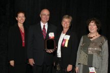
The review committee reported that the GISPs spent a good deal of time gathering information on their formal GIS and related classes, experience on the job and other activities that are worth points toward certification. One prospective GISP took two days off work. Another said it took three weeks, working on and off. The application form, which began its life at just seven pages, is now 26 pages. Those reviewing the packages reported that some submittals ran to 70 pages and included articles and other documents. Reviewers had to examine each application with a fine-toothed comb and tease out how to "count" such things as Web technology courses that might have included topics such as Internet mapping. The team is working on a "knowledge base" to document such decisions. It will be used and added to as more GISPs move through the process. (At left, Certification Chair William Huxhold, with just a few of the other members of the committee.) Certification mandates points be collected in three categories: educational achievement, professional experience and contributions to the profession. There are minimums for each one (30, 60, and 8 respectively), but the "rest" of the points can be in any category. The goal is a total of 150, the minimum for certification. Here are some of the other details: Certification is good for five years. Currently, the fee is $250. After five years, a re-certification will be available that will cover "what happened" in the five years since certification. That fee is not yet final. It will be interesting to see what percentage of GISPs "re-up." Classes and attendance at conferences claimed for points must be documented. At this year's URISA conference, attendees could pick up a paper noting their participation for use in certification. The conference program noted that attending one workshop and the conference was worth .6 participation points. I expect to see such information appearing in calls for papers, and other announcements and documents for conferences and classes. Work experience requires just a note from one's current employer. I asked about those of us who work for ourselves, in which case a note from clients will suffice. I know of at least one GISP who already has the letters after his name on his business card. Those whose applications are accepted are expected to sign the URISA Code of Ethics to become GISPs. Issues raised that suggest breach of that statement can result in removal of certification. The Board of Directors of GISC will take up such matters. Certification is open to anyone, worldwide. (Payment must be made in U.S. dollars, however.) There is a five-year period in which "grandfathering" will be available. Those who wish to do so can submit applications documenting experience only (not education or contributions) and potentially receive certification. It's my sense that the vast majority of the attendees at the URISA conference could achieve certification this way, if they so choose. GISCI's goal is a three- to four-month turnaround time for applications. The review committee will consist of five non-academic GIS-savvy volunteers. Rejected applicants will receive a portion of their application fees back and will be encouraged to try again at a later date. GISC will host a registry of GISPs on its website. ESRI, which has been a bit wishy-washy on certification in the past, has come around to support certification. At the URISA conference Jack Dangermond announced donations of some $335,000 in books and courses for the first 1,000 GISPs. These are GIS related, not product specific. The details on certification, as they stand, are available here. Note that GISCI is not prepared to accept applications at this time, but will do everything possible to meet a January 1, 2004 target date.

CERTIFICATION: WHAT DOES IT MEAN TO THE MARKETPLACE? The reality is that certification is here. How will certification impact the GIS community? I asked that question at a panel discussion at the conference and received some interesting replies: One certification committee member suggested that certification would be positive for education. It might encourage clearer course titles in schools, better documentation of professional courses, and more workshops. Another member pointed out that a "rubric" to match up existing GIS coursework to the University Consortium on for Geographic Information Science (UCGIS) curriculum framework is under development. Another response highlighted that language in procurements or contracts might include a "preference for certification." She noted, as did others, that since certification was voluntary it was unlikely that it would be "required" at least in the short term. Here are some of my thoughts on what I think may happen in the coming months and years: Marketing seminars by vendors, which mostly are free, will soon include "point values" on their fliers. Attendees will leave with papers noting their attendance. This gives me pause; I'm concerned about the slippery intersection of education and marketing. There may be a bit of a jump in contributed articles to GIS publications, since that's one way to collect contribution points. On a positive note, doing so may add more non-vendor written articles into our libraries. [GIS Monitor does not solicit externally written articles, although other GITC America publications, including EOM and Professional Surveyor, do.] Those who offer workshops will be expected to deliver Continuing Education Units (CEUs), if they don't already. The designation of CEUs typically involves approval by a university or professional organization. From my own experience, a class I taught several years ago, which provided CEUs for the American Public Works Association (APWA), required a $50 fee paid by the hosting APWA chapter. The number of GIS awards may grow. Awards for "GIS proficiency" count toward contribution points. I'm receiving more and more award press releases these days and wonder about their ultimate value. Those who support certification will use the term in advertising, contracts, and RFPs. They will apply for certification for themselves. Those who do not support certification will go on with their lives as employers and/or employees as they have in the past, doing GIS. To close on this topic, I want to reiterate something I wrote when I first covered certification in 2001: "From the employer's side, certification seems like a potentially useful hiring tool for some managers. That said, would I necessarily hire a certified individual over a non-certified one? I doubt it - just because someone doesn't bother to be certified, doesn't mean they're not a great GIS person." Certification, in and of itself, is not good or bad. Like technology, it depends on how we use it.

An interview last week Steve Kinzy summed up URISA's role this way: "URISA has settled into the role of providing national and international communication among GIS professionals. While vendors don't do a lot of direct sales at a URISA conference anymore, you can never be taken seriously by the GIS community unless you are at the [URISA] conference." URISA is certainly a communications hub. But I have to point out something that was brought to my attention the first day I was in Atlanta: there were but a handful of people from New England at the conference. We counted two vendors (Connecticut and Maine) and a few consultants (all from the Boston area). Travel restrictions are keeping more and more state and local people at home, perhaps preventing URISA and other conferences from achieving its goal in a very broad way. Recently I've been informally polling those in our industry on the role of conferences and trade shows. One consulting company executive I spoke with noted that GIS conferences have evolved much like medicine. Some years ago everyone went to a general practitioner. Now, at one point or another, we all visit specialists. She suggested that GIS conferences were, by necessity, moving in the same direction. Instead of large broader conferences, organizers and attendees are looking for shorter, more focused events. URISA is holding more one- and two-day conferences aimed at very specific topics such as addressing or specific geographies, like the Caribbean. All indications are that attendance is up and attendees and exhibitors satisfied. Another long-time show attendee balked at the idea of new conferences. He felt that the best way to introduce new content/geographic focuses is to link one-day or concurrent conferences on these to existing events. For example, an organizer might consider running an imaging event alongside a traditional regional or technology conference. The idea of "co-located" events was perhaps taken to the limit at the A/E/C SYETEMS shows in years past with some six conferences in one. That show has been sold and is now but a shadow of its former self. It seems that vendors' reasons for attending shows are changing, as Kinzy noted. In past years trade shows were the first point of contact for potential sales leads. These days show attendance may not be a cost-effective way to find leads. Other methods have become more popular and less expensive. According to one marketing manager I spoke to, the main reason for attending a show today is simply to connect with existing clients. As he pointed out, it's much cheaper to put a small team in a city for a few days and have the customers "come to them" than to do individual visits. That, I suspect, is why several vendors hosted user group meetings in Atlanta. These, by the way, were not just for attendees, but also for local users as well. As a journalist and a GIS consultant, I use a simple criteria for evaluating conferences based on James Burke's definition of information: information causes action. (His example, which I quote regularly, is "The person sitting next you has Bubonic plague.") Adapted for conferences, I ask: Have I run into "something" at the conference that "causes action?" When the answer is yes I head home happy, satisfied and looking forward to the action that will result. Conferences that send me home unmotivated and ambivalent are the ones to which I'm unlikely to return.

SAFE SOFTWARE'S FME SPATIAL DATA PROVIDER SERVER Perhaps you are thinking, what does Safe Software need to do with these specifications? Doesn't the company's software convert one GIS format to another? It's a fair question and gets to heart of what's "different" about this solution. Most conversions, Safe's or anyone else's, rely on some "intermediary format." Sometimes you write out data in that format and then feed it into the target system (DXF is often used that way). Other times the intermediary format file lasts only for a few seconds in computer memory. OGC, by the way, has data encoding designed for just that type of transfer job: Geography Markup Language (GML). But what if you want to access data directly, using no intermediary format? How do you do it? That's what the Simple Feature Specification (SFS) was designed to address. Unlike GML, which is designed to be very flexible and store whatever kind of spatial data might come up, SFS is very strict, very rigid, and deals with only a limited set of data types. As a payoff, however, there's no need to decipher the structure of the data and deal with the bulky text format of GML. Moreover, SFS client software (that is, software that implements the client-side communication interface) can directly access simple features from server software that implements the server-side interface. Dale Lutz and Don Murray of Safe are quick to note that while most of SFS is quite "clean," there are some "gray areas" that need to be agreed upon by client and server. For example, they note that coordinate systems are to be presented as "well-known text." It turns out that each vendor's idea of well-known text is a bit different. Here's how Safe takes advantage of SFS. FME SDP Server is an SFS server, that is, it can "send out" SFS responses to SFS questions. Inside, the product has all the FME libraries that allow it to speak to all the different data formats in Safe's bag of tricks. What that means is that FME SDP Server can serve SFS "live versions" of all sorts of data via its SFS interface. Any software that implements the SFS client interface can "ask for" and "receive" that data. Safe has tested FME SDP Server with ESRI's ArcGIS and Autodesk's MapGuide Server, but there are a number of other products that support SFS OLE/COM and theoretically should "just work." Safe invites vendors with SFS clients to contact the company to test out FME SDP Server. (For those who keep score, SFS comes in three flavors: SQL, OLE/COM, and a rather stagnant CORBA. Products can only talk to other products that implement the same flavor.) ArcGIS, a product that uses data, analyzes it and so on, may make more sense in this role of "client" than MapGuide Server. But MapGuide Server is itself a server - it serves data to MapGuide clients. So what's really happening in an FME SDP Server/MapGuide solution is that FME SDP Server is serving Simple Features to MapGuide Server, which then turns around and serves those features to MapGuide clients. That's called "service chaining" and as services grow, we are likely to see a lot more of it. So, why would someone choose to use FME SDP Server over the "old fashioned" solution to data conversion (batch updates every day or every week using FME)? The short answer: If the data of interest in those other formats are very volatile, changes many times a day, or are very large, then SPD might be for you.

DATA TIP This week's tip: Global Gazetteer from NIMA & USGS is a popular data product, often sold on the Web by commercial data providers or used as a starting point for commercial products. But did you know you can easily download it for free? Download Complete Files of Geographic Names for Geopolitical Areas from GNS here. The files are in a special [ASCII] format amenable to input in GISs, databases, and spreadsheets, giving end users powerful capabilities for data analysis, manipulation, and display. Coverage is global, except for the U.S., which is available from the USGS names server.

"I just wanted to share a few thoughts about your coverage of the URISA Conference in Atlanta in the October 16 issue of GIS Monitor, and clarify a point or two. "The vast majority of GIS 'Managers' I speak to say they have little interest in the finance of their operation, as long as the source is secure. I believe the hope that funding for GIS in local government will remain secure without thought and effort is a fool's hope. "It was interesting reading in your coverage that we left the impression that our GIS marketing efforts were 'poor.' We [the presenters] talked a bit about marketing going hand-in-hand with finance, but agreed to focus on funding models alone. At King County GIS, even though we've only tapped approx 25% of our market (more about that in a bit), I'd characterize it as the glass just 1/4 full - not 3/4 empty. We have had major success with our GIS marketing efforts in King County, both internally across each of the three biz lines I outlined, plus externally with local jurisdictions - developing significant new revenue sources. "A few months ago I was tasked with doing an analysis of a GIS needs assessment and strategic plan that [a consultant] completed for King County about 11 years ago. [The consultant] proposed a GIS implementation plan that was not funded because of cost . . . instead our county proceeded with a scaled back capital project. My analysis showed that our scaled back capital project, plus some supplemental technology bond funding, plus ongoing GIS operational activity in a variety of King County departments, has allowed us to completed most (but not quite all) of the data creation and GIS infrastructure recommended by [the consultant]. What was striking to me though, was that of the potential GIS business applications suggested by the consultant, we have completed only about 25%. Those that we have completed have tended to be the most mission-critical, plus some 'business-needs' have changed in King County eliminating some business needs - but this is the origin of the very rough 25% figure I used. "So in King County, our scaled back capital funding has allowed us to meet about 25% of our original 'needs.' Considering the reduced resources we had to work with, I believe our results have been very good." � Last week I noted a survey by Internet Week that highlighted that 2/3 of users of Microsoft software were dissatisfied with its product. A reader highlighted this disclaimer on the study: "The Reader Question is by no means scientific; we solicit responses on InternetWeek.com and in the newsletter and make no effort to qualify respondents. QuickPolls are the Internet journalism equivalent of man-in-the-street interviews and call-in talk radio." The reader went on to chide me for even referencing such a clearly suspect source. "It's trash, just taking advantage of the fact that of course everyone likes to beat up on Microsoft." I do urge readers to carefully read such disclaimers and determine for themselves the relevance of any survey information.

POINTS OF INTEREST SchlumbergerSema Sold. Reader Kirk let me know that Schlumberger, the French/American oil services firm, recently sold of most of its interest in SchlumbergerSema, the IT consulting part of the company. SchlumbergerSema, which recently won a big contract with UK's Department of Health, was sold to Atos Origin for $1.5 billion. Atos paid less than one-third the amount Schlumberger paid two years ago to acquire Sema Plc. Atos Origin is now the fourth largest consulting firm in Europe. Those with good memories will recall that SchlumbergerSema was the home of Convergent Group after its dissolution. Word has it that most of the GIS-savvy staff has been let go. Try a Second Life. Don't like your life? Try a Second Life. Second Life is a shared online world from Linden Labs. Mitch Kapor, Lotus founder, is now the chairman of the company, which developed and offers this "new world" where avatars roam and are able to transact business. The latest upgrade (v2.1) includes many spatial additions: improved map and online directories, access to a "driver's view" when traversing the world, support for land ownership and the ability to take "tolls" from those who want to cross. I find enough challenge just managing my first life! Look Out Autodesk! Disney, among all the other things it produces, now offers software used to design theme park attractions. Forbes reports that the package combines an "architect's 3-D, computer-aided design images with planning software that tracks construction schedules in real time." It "breaks down a 3-D image of a project into millions of pieces of data and then reassembles it step-by-step, in the sequence in which the structure will be built, to visualize how it will all come together." Disney has started a software company called Common Point to sell the software to those who develop and construct any type of structure. The software cost $1 million to create and the idea is to share development costs with others. Geography Matters to Instant Messaging. San Diego researcher William Griswold is behind ActiveCampus, a technology layer for universities that "seeks to augment human interactions with location and activity awareness." Active Campus Explorer, one application that's part of the suite, lists message buddies based on proximity and allows users to leave virtual graffiti for others read. One finding: people using the system tend to send more instant messages to people closest to them. "It seems to imply that location matters," said Griswold. "The way people relate to each other wirelessly is mediated by their physical proximity." I'm pleased we are testing this technology out on college students. Perhaps this will help meaningful business models develop outside the university.
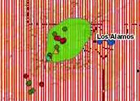
Geothermal Energy Maps. The U.S. Department of Energy recently released a series of maps that illustrate existing and potential locations for geothermal energy use in 13 Western states. Shown at left is part of the map of geothermal resources around Los Alamos, New Mexico. The green area shows areas with potential use for electricity. A New Crop for Northern Canada. Researchers are using GIS to identify areas where eastern yew trees currently thrive and where an industry built around them might be located. The plant has potential for use in alternative medicine and may help bring non-timber based jobs to Northern Ontario. The Future of NIMA Maps. Lt. Gen. James Clapper, director of the National Imagery and Mapping Agency, speaking at Geo-Intel in New Orleans last week showed pictures of a warehouse full of unused maps developed for the Iraq War, according to a report from Reuters. Other images showed soldiers looking at paper maps held in place on the ground by orange traffic cones. The article notes that Clapper wants to move to custom, on-demand printed maps, since "Hard copy maps are out of date before the ink dries." Sensing in the Rocks. Research by Wessex Archaeology and 3D laser scan firm Archaeoptics have found "invisible" images at Stonehenge. The groups use low-powered lasers to reveal carvings that are too badly eroded to see with the naked eye. The lasers apparently do not further damage the rocks. Remote Sensing for Baby. The baby monitors that broadcast sounds from the infant's room to Mom and Dad are old hat. Now monitors from Philips Electronics can also let parents know the temperature in the other room. Interestingly, it also shows, by means of lights, the sound level in the room. I'm a big fan of my remote thermometer. I have a sensor on the fence in my back yard that transmits to a clock in my bedroom. I use it regularly to select appropriate running clothes for those cold mornings. Locating Ocean Garbage. Scientists are using circulation models, satellite imaging and thermal imaging to locate "ocean garbage" (New York Times, free registration required) that may be harmful to marine life. Most of the debris is from industrial fishing, logging and dumping. The joint venture between NASA and National Oceanic and Atmospheric Administration (NOAA) is focusing on locations where garbage may collect. One particular target: synthetic translucent nets that can trap virtually all sea life. 10 Ways. I mentioned a forthcoming paper by the Open Data Consortium that describes 10 ways that GIS operations can be supported without having to sell geodata. The paper and presentation slides are now available on the ODC website under "News/Links." The final model policy document should be available in the next week. Autodesk Partner Calls it Quits. Longtime Autodesk partner/reseller DTI announced in September it would be ending its relationship with the software developer. The website points users to three other New England Autodesk partners. DTI merged with Computersmith of Hudson, New Hampshire in 1996. Computersmith shop was the first place I ever saw ArcCAD and was one of the leading GIS resellers/vendors in the region. The leading MicroStation reseller in New England, Rowse and Loring, severed its reseller relationship with Bentley several years ago. There are some interesting dynamics in the reseller channel, at least here in New England. And the Dominant User of Commercial Imagery is � Frost & Sullivan's new report on World Commercial Remote Sensing Imagery, GIS Software, Data, and Value-added Services Markets notes that the industry generated revenues totaling $5.39 billion in 2002. Total market revenues are expected to reach $8.33 billion in 2007. The biggest user of commercial imagery: governments. A recent article by Don Segal suggests how to increase imaging uptake in the business sector. Why Coffee and Donuts Don't Mix. Ever wonder why Starbucks and Krispy Kreme don't mix geographically? A columnist for The Detroit News takes on this exact question. Turns out, as she puts it, "Starbucks goes upscale, to burbs and locations that attract 'connoisseurs' and 'metropolitans,' and "Krispy Kreme moves just as decisively into neighborhoods that are neither fashionable nor new, where counting carbs isn't a community sport." She also cites data, and this is the first time I've seen ESRI described as "market research firm, ESRI." She's referring, I'm sure, to ESRI-BIS. Here in my neighborhood we do indeed have our only Krispy Kreme in lowbrow Medford and Starbucks just about everywhere else, including not one, but two, in the up-and-coming city of Somerville. Last Week for Survey. If you've been putting off responding to our survey for GIS Service Providers please note that since only a select few, the GIS service providers, can respond, chances of picking up a raffle prize (the prize closest includes mobile GIS software, desktop GIS, books and more) are quite good. Besides, our questions are, well, a bit different than everyone else's. Quote of Week I. "MapInfo has the expertise in the application of location intelligence to business analytics." Mark Cattini, MapInfo president and chief executive officer made this statement in an interview with a Malaysian paper. The company is opening an office in Singapore. I find this description of what the company does confusing, but perhaps this is the language that business people and CIOs speak? Quote of the Week II. "A few years ago, we wouldn't have been recognized for anything other than the ability to blow up satellites." Walter Scott, chief technical officer at DigitalGlobe describing the company at the ceremony announcing him as the winner of the Boulder Chamber of Commerce's Esprit Entrepreneur of the Year. Quote of the Week III. "However, the development and growth of the use of mapping data is being held back by poor commercial sense on the part of the agencies that own the data and poor implementation of standards from solutions providers. It appears that the market domination of ESRI may be partially to blame for this." Steve Barrie of Bloor Research writing in IT-Director.com on what's wrong in mapping.

� Announcements Mobile operators are forecasting major growth in revenues from high accuracy location-based services to almost $12bn by 2005 - but only if low cost mass market enabling technologies are in place to drive the market. Overall, operators forecast average annual revenues of $12 per subscriber from location-based services in 2005 - growing to $35 by 2008 - according to an in-depth operator survey by Cambridge Positioning Systems (CPS). CPS is a location technology provider. Applanix's parent company, Trimble, has acquired the assets of the Emerge Sensor Group (Andover, MA) from ConAgra Foods Inc (Omaha, NE). The transaction includes the company's intellectual property rights and product designs. Groupe Alta will buy G�omatique EMCO inc., a data creation company, and DVP-GS inc., a producer of imagery and GIS software. The New Jersey Geographic Information Network portal, njgin.nj.gov, is now available. New Jersey Mapping Assistance Partnership Program hopes to get all 21 of the state's counties to publish their GIS data on the portal. Six counties have now joined the program and four have put their data online. The portal is built on ESRI technology and it looks just like GeoData.gov. Ivan A. Getting, a Cold War scientist who conceived of the Global Positioning Satellite system died at 91 on October 11th. Several vendors have announced the Wireless LBS Challenge: a call to the LBS industry to develop interesting, useful LBS applications that will work with cell phones or wireless handheld devices using GPS technology and NAVTECH maps. Ubisense (that's Warren Furgeson, formerly of Smallworld's company) announced it has a demo system running that implements a single `location cell' of what it calls a Local Positioning System (LSP). Multiple small location tags, called 'Ubitags', are tracked in real time and their positions are displayed on a map as they move around. According to the company, the system is the first of its kind to enable 3D real-time tracking down to an accuracy of six inches (15cm). The Portland Development Commission (PDC) has added an online mapping tool to its website to help business owners learn about city grant and loan programs. For example, users can find out whether an existing business or property is located in areas that PDC has targeted for economic development assistance, such as enterprise zones, the storefront improvement program, and urban renewal areas. The Greater Fort Bend (Texas) Economic Development Council was selected as the recipient of the Global Innovator's Award given each year by CoreNet Global, the professional association for corporate real estate leaders. The system quickly deciphers the viability of development sites. Telcontar, a supplier of software and related services for location-based services (LBS), announced that it has entered a strategic partnership with RACO Wireless. Under the agreement, RACO Wireless will use Telcontar's Drill Down Server and Traffic Manager software platform products to enhance its existing library of industry leading LBS applications, and to design new applications in the future.

� Contracts and Sales Spectrum Mapping, LLC has been awarded a contract by Douglas County Public Works, Engineering Division, to generate topographic base maps and orthorectified digital color imagery as part of the Hayman Fire Area Floodplain Mapping Project. General Dynamics Network Systems, a business unit of General Dynamics, has been awarded a contract to provide geographic information services in support of the operations of the U.S. Forestry Service's 18 national forests in California (Region 5) and its Remote Sensing Laboratory. The contract has a maximum potential value of $20 million. Roanoke County, Virginia will implement Novalis' suite of land records products including Assessment Office, Land Development Office, Parcel Editor, and GATE. Team ERDAS (Leica Geosystems Defense Solutions (Alexandria, VA), ESRI (Redlands, CA), Earth Satellite Corporation (Rockville, MD), Optia (Altoona, PA) and Integic Corporation (Washington, D.C.) has been chosen to participate in the National Imagery and Mapping Agency's (NIMA) Soft Copy Search (SCS) research and development program. The ultimate goal is to completely transition imagery exploitation to a digital environment. ESRI announced that its Colombian distributor, Procalculo Prosis, has won a contract with the Geographical Institute Agustin Codazzi (IGAC) to replace its existing automated mapping and cadastre system. The new system is based on ESRI's ArcGIS software and ArcCadastre, which was developed by Lantm�teriet, the national land survey agency for Sweden, with the help of ESRI. � Products Sharp Systems of America has introduced the Actius RD3D, a notebook computer that incorporates Sharp's TFT 3D LCD technology, which makes it possible to view 3D images using the naked eye, but is easily switched back to 2D viewing for standard applications such as spreadsheets, photo editing or e-mail. The company claims it's good for GIS. Maptech's Terrain Navigator Pro now includes a free ArcGIS Extension that eliminates file format problems. ArcGIS 8.3 users can now use Maptech's raster cartography directly - without going through the process of exporting, importing, or reprojecting the maps. MapInfo has announced a new series of Census Data PowerPacks based on the UK 2001 Census. Thales GeoSolutions (Pacific) has introduced a new export utility, DXF Page Exporter, providing ESRI's ArcGIS users with the ability to export a map frame or a page layout as a DXF file. In addition to enabling geographic information system (GIS) users to export data to DXF files, DXF Page Exporter now allows the export of a map to a DXF file, at the same time preserving the map symbology. Free eval here. Tele-Atlas released MultiNet for Poland, a product that interconnects the street network of the country into the company's European database. Autodesk Location Services announced the Autodesk Traffic Connect - SMS Short Message Service) Edition. This new version of the Traffic Connect application delivers up-to-the-minute, location sensitive traffic information to wireless subscribers using text messaging (SMS). Subscribers can receive relevant reports on traffic conditions automatically or on demand, a new feature that enables the person to receive traffic information by simply sending a text message to the service provider. The group also announced the latest version of Autodesk Location Connect 4. The product provides carriers with the ability to offer consumer and enterprise customers location sensitive applications. ARCBridge Consulting & Training, Inc. (ARCBridge) has announced that its TIGERSolv conversion program can now be obtained for free. This program is a standalone utility that requires no GIS software. It converts TIGER 2000 and TIGER 2002 data into an ESRI shapefile format. PCI Geomatics Geomatica 9 FreeView, the latest no-cost spatial data viewing environment from PCI Geomatics, is now available for download via the company's website. Users can view, layer, and evaluate raster and vector spatial data. Thales Navigation, a provider of Magellan GPS solutions, announced two new vehicle navigation solutions in the Magellan RoadMate series to be introduced in time for the holiday buying season. The portable Magellan RoadMate 500 (limited maps can be uploaded) and 700 (complete U.S./Canada maps) are the first products to offer simple, affordable yet fully-featured street navigation. � Education and Training The Spatial Science program at Charles Sturt University in Wagga, New South Wales, Australia received $100,000 in student scholarship grants from the Department of Lands for mapping projects. ESRI Virtual Campus presents Creating and Editing Geodatabase Topology, a new course designed for ArcEditor and ArcInfo users who want to learn how to create a geodatabase topology and edit feature classes that participate in a topology. � Events The Red Hen Systems User Conference will take place March 4-5, 2004, at the Holiday Inn University Park in Fort Collins, Colorado. DataVision GIS, in conjunction with ESRI Australia, Ultimate Positioning and RIA Mobile GIS, will host a Mobile GIS Seminar on November 6, 2003 in Hobart, Australia. The seminar is free but registration is required by October 31, 2003. � Hires and Appointments UCLID Software announced that Dan Carlson has joined the company as VP of Business Development. Formerly with Fidlar Software, Carlson will spearhead UCLID's efforts to promote automated indexing solutions for county government and title insurance companies.
ADVERTISE WITH US
CONTACT
SUBSCRIBE/UNSUBSCRIBE |