Letters, Points of Interest, Week in Review, Back Issues, Advertise, Contact, Subscribe/Unsubscribe
URISA DOWN, BUT NOT OUT That, as I've said before, needs some serious examination. When you attend a conference, why do you do so? Is it for the vendors? I'd argue that at GITA the big focus is on the vendor hall. Hours are strictly limited and vendors are encouraged to use the "downtime" for private meetings with potential/existing customers and journalists. My sense is that attendees value that time more than other facets of the event. Do you attend a conference for the papers? That, I'd argue, is the focus of vendor specific shows - the ESRI User Conference (both the large international one, and the regional ones), Intergraph's GeoSpatial World, and Autodesk University. MapInfo's MapWorld probably fits here, too, but I've never attended that one. The papers I have seen at these events address the exact problems a user might have: How do I load this type of data into this product? How do I model waterlines in this product? How does this new product work? The trick at these meetings is to mix the vendor-provided papers with the user papers so the conference is not a full-scale sales pitch. Perhaps you attend conferences to meet new people and get their perspective? I've been attending GIS shows fairly regularly since 1992. At first I thought the papers were the "be all and end all" - until I realized that many are written while traveling to the conference. Others are simply sales pitches. Some conferences require that papers be submitted months in advance to be included on the CD. While you'd think that would produce worthwhile presentations, it can limit the inclusion of recent events (technological and otherwise) and make the presentation seem dated. I will say that at every conference I've attended I can walk away saying that a handful of papers were worth the time spent. I keep a mental list of speakers I learned something from and try to catch them again. See, for example, my notes on speakers at GITA this past year. Further along in my show-attending days, I thought the value was meeting with the vendors to see "what's new." However, many vendors rent actors to sell the products and it can be tough to find the person who can answer your questions. Others use the vendor floor as a place to gather potential leads - and that's all. "Sign up - get a T-shirt" has limited allure in the long run. So, why do I attend these events? Really, it's to meet people in this industry that I otherwise would not. Some attendees, I've found, have the same problems and challenges as I do. Others are in a totally different part of the discipline and can give me a sense of why that part is important. So, which conferences are most rewarding for me? The ones where I have more opportunity to meet people. The ones where, after the three or four days, I know a few more people by name, who have interesting ideas that they've shared. I've crossed paths with them, not just once, but more than once, so that a running conversation is developed. I have a hunch that this year's edition of the URISA conference was like that.

OPEN SOURCE IS GOOD ENOUGH FOR DEFENSE; IS IT GOOD ENOUGH FOR YOU? The list of 115 FOSS products in use at DoD found in a two-week study include many that underlie basic computing: Linux, various varieties of the BSD operating systems, Samba, Apache, Perl, GCC, bind, and sendmail. Samba was perhaps the first FOSS software I came across - we ran it at ESRI Boston to make our UNIX machine disks accessible to Windows machines. The report puts the FOSS software in use into four areas: Infrastructure Support, Software Development, Security, and Research. The report makes three suggestions that all encourage FOSS software within (and I'd argue without) DoD. First, make a list of commercially supported, widely used software that has a good track record. Second, create policies within DoD to encourage the use of FOSS software and commercial software that works well with FOSS software. Third, encourage FOSS use as part of a software diversity plan - to lower the risk of dependency on a single product, and lower risk of successful cyber attacks. I did a quick look over the 115 programs to find mapping/GIS tools. I found BBN Technologies' OpenMAP, a JavaBeans-based programmer's toolkit that allows Java applications to access map data. It was found in use in two areas. Again, this was a quick two-week survey, so it's likely there are other FOSS GIS products at DoD. So, what does this say about FOSS software and GIS? It's worth pointing out that the perhaps most famous FOSS GIS software, GRASS, was at the core of the creation of the Open GIS Consortium (OGC). The OGC now encourages the use of Standards-based Commercial Off-The-Shelf software (SCOTS) but clearly, the ability of those products to work with FOSS software, via open specifications, sounds like just what Mitre is suggesting for DoD. The Open GIS Consortium is a client of my consulting company, and I live a stone's throw from the center of the FOSS universe, Richard Stallman's Free Software Foundation, based in Boston, MA.
PLAYING WITH MAPORAMA After publishing so much news from Maporama, I figured it was time to have a look. One reason I've not looked at Maporama, I suppose, is that the company calls itself "the leading European provider of location-centric applications consisting of high-quality advanced mapping and routing." I don't generally need information on Europe, but Maporama does cover the U.S., so I gave it a shot. Am I ready to give up on MapQuest? Not quite. Here are some reasons why: � Maporama covers a lot of ground. The company notes that it has maps of every country and 635,000 cities. � Maporama offers "normal" and "interactive" options when finding a map. The normal map is raster, the interactive one, vector, I think. You can choose which type makes sense for your query. The interactive seemed to have "live" zooming (that is, without a return trip to the server) but caused my browser to crash twice. � The default map is very nice. It includes one-way streets and address ranges. The address of interest is circled, and the block highlighted. Another bonus: the latitude and longitude coordinates are provided for the geocoded location. And, you can customize the map for delivery to your handheld device by choosing black and white vs. color, a map for pedestrians or cars, or using a variety of country "styles" among others. � Directions are provided for three different modes: by car, on foot, or via the subway. Car directions are in meters (by default but can be changed) and use European road type symbols. If you change from km to miles you'll get directions that say things like: "Follow Harvard St for 538 feets." The program said I could not take the subway from my house to a northern suburb of Boston (correct), nor could I take it from my house to a location in downtown Boston either, though in reality, I do this all the time! Oddly, the map of Boston has lots of little boat symbols - many of which are on land. I could not find a legend for them. One nice touch: you can include several "stops" in the creation of your route. On the whole, Maporama offers quite a lot, but to U.S. tastes, may seem a bit foreign. The company is most interested in using its capabilities on partner sites and on wireless phones and devices.
REFER A FRIEND, WIN A PRIZE! To add your friend(s) to the subscriber list, visit our referral page. Good luck and thank you for your continued support!
LETTERS "Your article on ESRI's moves to consolidate its position was fascinating. (As was the one on Pictometry, but that's a different subject.) "I've been thinking about the Open GIS Consortium's [OGC] testbeds and specifications. It's taking between a year to two years to get specs out of OGC. There are a ton of things in the pipeline. In fact, there is always so much going on that it seems like the vendor participants are stretched far too thinly to allow OGC to get about its business of developing specifications. "At the same time, the ESRI juggernaut is positioning itself in the major markets and seems to be relentlessly growing market share. Things are getting to the point where there is a question whether there will be any significant competition in the GIS marketplace 10 years from now. "It seems as if OGC is unwittingly playing into ESRI's hand by not being able to concentrate. Without a full complement of specifications, and implementations from multiple vendors whose products actually interoperate, ESRI can continue to dominate the marketplace. "OGC's gotten itself on the radar screen of most major GIS agencies around the world and is in a position to really foster competition in the industry. So, what is going so horribly wrong that ESRI can advance as quickly as it is? Why is there still no true interoperability other than at the Web mapping level? "I think it's a classic case of taking your eye off the ball. OGC and its supporters need to redouble their efforts behind true interoperability rather than on the massive, ever-increasing amount of half-finished work that is being generated." The editor notes: My consulting company counts the Open GIS Consortium as a client. � Dale Lutz from Safe Software suggests another spam fighting option after last week's look at ChoiceMail: "Regarding SPAM filters, we've started using one called 'spamnet' that is very good and in many ways less intrusive than the one you were mentioning. Basically it works like a napster for spam, in that when you get a spam piece, you hit a 'block' button, which registers that spam with a server. When enough users use this thing, spam is always being voted on and the p2p [peer to peer] nature of it results in excellent spam removal. "Anyway, it's been very painless and produced excellent results for me." � Gary Quinton reported hearing "geographically undesirable" in another context: "I first heard the term 'geographically undesirable' on the Car Talk show on National Public Radio. Tom and Ray use it in the sense that if your car isn't up to the trip, a long distance relationship may be 'geographically undesirable.'" "Well, I'm no cartographer, but if you handed me that map, I wouldn't know what you are mapping. The legend at the bottom is all well and good, but an explanation of what attribute is being mapped makes a huge difference!! I presume it is population density." � Tony Leno pointed out that I had the wrong date listed for the Avatech online GIS seminar last week. I reported it was scheduled for Friday. In fact, it was on Thursday. It turns out there was an error in the press release that I read. Avatech has offered a private seminar for Leno's organization.
POINTS OF INTEREST
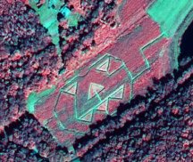
� To celebrate Halloween, here's a pretty picture of a pumpkin from the IKONOS satellite. I chose the false color image, since it looks more pumpkin-colored than the true color image. Robert and Billie Mason planted the field on purpose, but according to a Lexington Herald-Leader article, did not know it would be visible from space. Susan Carson Lambert at the Governor's Office for Technology in Frankfort described it as "a hoot," and decided that "somebody over in Eastern Kentucky has a heck of a sense of humor." Thanks to Space Imaging for permission to republish the image. � Computer consultant Stephen Whitaker did it in Vermont and he's on his way to doing the same thing in Connecticut. What did he do? He fought local government so that he could repackage and sell GIS data. This week, the hearing officer for the Connecticut state Freedom of Information Commission dismissed the town of Greenwich's claim that releasing the data in its geographic information system would compromise security. The data was turned over to Whitaker. A commission vote is scheduled for November 15. First Selectman Richard Bergstresser said in a Greenwich Time article, that if the town loses the battle, he'll release the data on the Internet, just so that Whitaker can't profit from it. I guess that won't compromise security. � Wired reports that Applied Digital Solutions, the maker of an implantable human ID chip is offering $50 discounts to the first 100,000 people who register for microchip installation. The FDA granted the product unregulated status for "security, financial and personal identification/safety applications." An implantable GPS ID chip prototype is expected by the end of the year. � Intergraph Corp. said on Monday that a U.S. judge rejected efforts by Intel Corp. to overturn a ruling against Intel. Intel asked the judge to reconsider his ruling on patent infringement, or to grant Intel a new trial. The judge rejected the request on Friday. On Wednesday, the two companies will appear to discuss when Intel must pay Intergraph $150 million per the original agreements. Some analysts think that Intel has a chance of winning on appeal. � According to a mobile user report reviewed at Wireless NewsFactor from the Yankee Group the top application of interest to mobile users is location-based information services (LBS). The poll noted that LBS generated the most interest among those polled, at 36 percent. � The Boston Globe interviewed Tom Colatosti, who currently heads up a local investment firm, but was the leader of a face recognition technology company. The questions were about how companies are coping with the lack of Federal homeland security money. He highlighted some interesting ideas. First off, there is capital available. The challenge is that investors don't want to research 10 companies with fingerprint technology and pick one. They want consolidation, so there is just one company in which to invest. Second, he points out that many companies that have lackluster performance today continue explaining it by saying they are waiting for homeland security programs. What really happened? They dropped their business plans after 9/11. Third, he answered the question on everyone's mind: What happened to the funding? Colatosti says two things happened. First, money went to labor and not technology (all those airport screeners for example, but not new screening machines). Second, the big surplus we expected in the federal budget isn't there. It's interesting to consider these ideas in the context of GIS and homeland security. � The folks at Taco Bell are zero for two in their offers to feed the U.S. population tacos should falling objects hit the fast food company's targets. This past week, during the all-California World Series, the company offered tacos to the country's residents should a homerun ball hit a 15-foot floating target in San Francisco Bay's McCovey Cove. It didn't happen. Last March the company offered the same deal, should the Mir spacecraft hit a 40 X 40 foot target in the South Pacific Ocean during its fall to Earth. The Station missed. � SRC has launched a campaign aimed at "turning in" existing MapInfo TargetPro customers. The deal is this: for each customer "turned in" with a national TargetPro system that SRC switches to its technology, the referrer will receive $1,000. Smaller system owners yield smaller dollar amounts. The original e-mail was distributed on MapInfo-L. Recall that MapInfo and SRC are suing each other. � How hot are in-car navigation systems? According to J.D. Power and Associates, only 175,000 of the vehicles sold in the United States in the 2001 model year had a navigation unit, just 1 percent of the 16.68 million vehicles sold in that model year. According to Automotive News, the big changes that need to made, according to attendees at Convergence 2002 held in Detroit last week, include a lower price tag (> $500) and support for real time traffic information. � One more "GIS" definition. A press release from OPTIMUS Corporation, which specializes in public safety technology, refers to it as "Geospatial Information System." Kim Larkin who takes care of media relations explained: "We consider the terms 'Geospatial' and 'Geographic' interchangeable. It is my understanding that 'Geospatial Information Systems' is a bit more well-known in the government and military." � There's a new type of remote sensing being tested this week. According to Reuters, researchers from the Massachusetts Institute of Technology and University College London will "touch" using a new type of sensor that transmits via the Internet. � The California Milk Processors Board received one reply in its search for a small town that wants to consider changing its name to "Got Milk?" Voters in Briggs, CA (north of Sacramento) will have their say on November 18. There is no financial incentive offered to the town, originally named after a local family, some 100 years ago. For comparison, in 2000, Halfway, Oregon, changed its name to "Half.com" for $73,000 from a Philadelphia startup and Hot Springs, New Mexico, changed its name to "Truth or Consequences" in 1950 in a stunt from the radio show.
� Announcements Trimble Navigation Ltd. says its third quarter came in better than it had expected. For the quarter ended Sept. 27, revenues were $114.7 million compared with $117.4 million in the year ago quarter. Its earlier revised guidance had estimated revenues between $110 million and $112 million. Maporama announced a version of its website. The Demography Department of the Institute for Social Sciences, Humboldt University in Berlin, the first European GeoMedia Research Grant recipient was awarded $5,000 (U.S.) and a $50,000 software by Intergraph Mapping and GIS Solutions. The grant is part of an education program to encourage applied geospatial research. The Demography Department is undertaking the research project to address the need for a comprehensive, easily accessible data management system to link the city's disparate data to multiple users in an interactive environment. Pocket PC Magazine announced that Mapopolis has received the Pocket PC Magazine "Best Software Award" for the Maps and Directions category. This award was announced at the Pocket PC summit located in Hollywood, CA. Team ERDAS has been chosen as one of three finalists for NIMA's SCS Soft Copy Search (SCS) research and development program. Leading Team ERDAS is ERDAS Defense Programs (Alexandria, VA), which is partnered with Integic Corporation (Chantilly, VA), ESRI (Redlands, CA), Earth Satellite Corporation (Rockville, MD), and Optia (Altoona, PA). The Open GIS Consortium, Inc. (OGC) announced a Call for Sponsors for a Feasibility Study that will support the next phase of the OGC Web Services (OWS) Initiative. As part of the new Radius Academic Programme, academic and research institutions will be able to incorporate Radius Topology into their projects. The Radius Academic Programme at Laser-Scan established a network of universities worldwide to allow the open exchange of ideas and information. Laser-Scan aims to facilitate this exchange through open correspondence, presentations and reports. As well as receiving the complete Radius Topology package for free, participating institutions will also be offered the chance to take part in seminars and workshops. Avineon, Inc., announced that it has acquired most of the assets of AGRA Baymont, Inc., Clearwater, FL. Until June, Avineon was known as InfoTech Enterprises, Inc. The company's headquarters are in Alexandria, Virginia. Avineon India Private Ltd., established in 1998, is a software development and data conversion facility in Hyderabad, India. AGRA Baymont, Inc. acquired the assets of Geonex Corporation in February 2000. Baymont is owned by AMEC, Inc. Avenza Systems Inc. announced that it has provided MAPublisher software to the volunteer group Shinai Serjali so that they may more effectively support recently contacted indigenous groups in the Peruvian Amazon. � Contracts and Sales CARIS will provide the Province of Nova Scotia with CARIS Land Information Network (LIN) to modernize and streamline Nova Scotia's real property system. Webraska announced that O2 Ireland, a wholly-owned subsidiary of mmO2 plc and a leading network operator, has chosen Webraska's portfolio of LBS applications and SmartZone middleware platforms for the deployment of Locator for Wap, Web and two-way SMS. ESRI will receive $26.25 million to develop a mapping system for national intelligence agencies. (registration required) Also mentioned here. iSECUREtrac Corp., a company that focuses on the development of global positioning systems (GPS) for tracking and monitoring, announced that Court Programs, Inc., a company that deals with probation and house arrest services, will deploy iSECUREtrac's tracNET24 monitoring system in Mississippi and Florida. Dr. Martens, the footwear company, chose Maporama, as a provider of location-centric solutions to provide mapping functionality for its website. PlanGraphics, Inc., has been retained by Boyle Engineering of Newport Beach, CA, to provide GIS application development services in connection with the Sewer Master Plan for the Cities of Rossmoor and Los Alamitos, California. Claritas Inc., a provider of intelligent marketing information and target marketing services, and Gannett Co., Inc. have signed a three-year agreement that provides the media company with a suite of market information tools aimed at increasing advertising revenue and growing circulation, including Claritas' signature lifestyle segmentation system, PRIZM. The United States Army Topographic Engineering Center (TEC), a division of the Army Engineer Research and Development Center, has purchased multiple licenses of Visual Learning Systems' Feature Analyst software. Cape May County (NJ) officials have begun using wearable computers from Xybernaut Corporation to do everything from tracking wildlife, to monitoring water supplies, to mapping road signs and buildings. � Products. Emc3 introduced the Geoclip platform, a solution for publishing interactive maps on the Internet. Geoclip uses the Flash format to offer large-size maps whatever the user's environment and browser. Orbital Imaging Corporation (ORBIMAGE) announced the launch of a new feature related to its world renowned SeaStarSM Fisheries Information Service. Sub-Surface Temperature Information is now available to all subscribers of ORBIMAGE's SeaStarSM Service as an additional component to support the analysis of probable fishing grounds. EMTAC Technology Corp., Transplant Computing, and Mapopolis, Inc. announced the release of the EMTAC Wireless GPS Bundle for the Palm OS platform. The bundle combines the first commercially available Bluetooth GPS unit with Mapopolis Platinum Edition navigation software. Thales Navigation introduced the first full-color handheld GPS receiver. Currently available exclusively through Sharper Image retail outlets, and more widely available in the spring, the Magellan Meridian Color is the new flagship handheld of the premium, high-performance Meridian series. The Meridian series are the only GPS receivers to offer unsurpassed memory expansion through industry standard Secure Digital (SD) memory cards for downloading data.
Research Systems, Inc. (RSI), a wholly owned subsidiary of Eastman Kodak Company, announced that IDL 5.6 for Mac OS X will be released in early November. � Hires and Appointments. Joakim Oll�n, Director General of Lantm�teriet - the National Land Survey of Sweden), has been appointed as the new President of EuroGeographics. According to the website, EuroGeographics is the "voice" of the official map-makers of Europe and exists to help those who need to use the geographic Information that they create.
ADVERTISE WITH US
CONTACT
SUBSCRIBE/UNSUBSCRIBE |