Letters, Points of Interest, Week in Review (Announcements, Contracts, Products, Events, Hires) Back Issues, Advertise, Contact, Subscribe/Unsubscribe If, for some reason you cannot read this document, visit: http://www.gismonitor.com/news/newsletter/archive/111303.php
SERVICES: TAPPING INTO THE SOURCES For those who haven't kept up with TerraServer history (I'm one of you) here's why the TerraServer website and URL (www.terraserver-usa.com) might look different than what you recall from a few years ago. When TerraServer was launched it included data for the U.S. (from USGS) and data for other parts of the world (SPIN-2). TerraServer's lease on the SPIN-2 data was only for 18 months and once the term expired the firm providing the lease decided to host its own website, www.terraserver.com. That website currently sells imagery but to my knowledge does not offer a Web service. Microsoft Research decided to host only U.S. data (all public domain) at www.terraserver-usa.com. To be clear, from here on out, I'm referring to Microsoft Research's TerraServer. I tried to remember what I knew about TerraServer. It supports .NET, I recalled, but it also supports the Open GIS Consortium's (OGC) Web Map Service (WMS). [I consult to OGC.] Then I remembered that one of the new features in MapInfo 7.5 was that it was a client to WMS. (I wrote about that a few months ago.) Therefore, I reasoned, anyone with a little knowledge should be able to access the TerraServer data for $0.
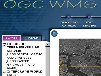
I wanted to try it out, but I don't have a copy of MapInfo Pro 7.5. So I used a stand-in: Intergraph's WMSViewer, an online viewer (at left, that's a bit of Boston's Logan Airport) that supports WMS. (As I finish writing this, Intergraph has just announced that the code for WMSViewer is being made available to the public at large.) I reasoned that if I could get this viewer to use the data, I could do it in MapInfo, too. TerraServer has its own WMS viewer, too. Basically, the only thing you need to know to use a Web Map Service is its URL. That should be easy to find, but for TerraServer it's not. The TerraServer webpage about WMS does not put the URL in big letters; I had to guess from looking at the capabilities page (that's an XML document that tells client software that comes to visit the server what the service can do). I learned after a few tries that you need to feed the client the URL of the service's capabilities page, in this case it was http://www.terraserver-usa.com/ogccapabilities.ashx. If this website looks "wacky" to you, don't worry. It's just XML, something a computer, not you, typically reads and uses.
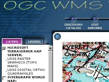
The good news is that once I added that new service to the WMS Viewer I could see DRGs and DOQs (at right, same part of Logan Airport). And, it was free! (If you need further proof that this is possible using MapInfo Professional, note that the graphic that accompanied the article I did on MapInfo Pro 7.5 actually illustrates MapInfo tapping into the TerraServer data via WMS.) Good news for those using ArcGIS: the ArcGIS Interoperability Toolkit which includes (among other things) an extension to ArcGIS to make it a WMS client is slated to be available at the beginning of December. One more point about TerraServer, I understand that its images are converted to JPEGs to save space. That, say posters to newsgroups, brings down the resolution. If you want higher resolution DRGs or DOQs delivered you may need to look elsewhere. One suggestion I received repeatedly: TopoZone.com. That brings us back to Mapping Solutions TerraViewer. I understand the product does offer a significant value-add over simply tapping into TerraServer via WMS. Stay tuned for more on that in an upcoming issue.

COVERING CONFERENCES The answers to the queries are as follows: I was not invited, nor did I have funding, to travel to Africa this fall. I was also unable to attend NEARC (which I've covered in the past) as I was traveling elsewhere last week. I'm most pleased that readers want to see coverage of these important events. And, for the most part, I enjoy traveling to cover GIS and related topics, around my other obligations. Editing (that is, writing) GIS Monitor is but a part-time gig for me. The other factor of course is funding. While GITC America, which publishes GIS Monitor sets aside resources for some travel, there are times when I must look to other sources. On more than one occasion my consulting clients provided funding, for which I'm most grateful. If you'd like for me to attend a conference and cover it in GIS Monitor, please let me know well in advance. I've received requests literally the day before an event in a distant city, and in one case received a notice of an event the day it was held! Most conference organizers are happy to offer press credentials (that is, a free registration and a cool "press" badge, and sometimes other goodies, like Internet access) to a limited number of members of the press. If conference coverage - past or future - from GIS Monitor is valuable to you, please let the event organizers know. Also, let our advertisers know, too. They keep this publication coming each week!

"One note I wanted to clarify on the DigitalGlobe article - the Boulder newspaper is actually called The Daily Camera [as opposed to The Boulder Camera]. "I also have to disagree with your assessment of GIS vs. CAD. � The lineage of CAD and GIS is shared in some cases, but very different in others. As GIS solutions evolve I do not believe that it will follow a similar path to what has happened in the CAD market space. This is mainly because GIS is more of a database-driven technology, whereas CAD is clearly based on drawing/drafting capabilities, which have not really changed much in the last 10 years or so. I think a better indication of where GIS is headed is based on what Oracle is doing in their new 10g product offering with the Spatial and Locator options. Perhaps you could include more on that in your next issue." The editor responds: My apologies to the staff at the Daily Camera, which I read regularly because of its in-depth coverage of the many geospatial companies in that area. As for more on what Oracle is up to�I've contacted the spatial team, which is conveniently located not far from me in New Hampshire, and plan to visit soon.

POINTS OF INTEREST Only-Slightly Geographic Toys for Runners. An Associated Press writer reviews the Timex Bodylink System, which he carried while running the New York City Marathon. The system includes a GPS transceiver, which is strapped around your arm and a special digital watch it to which it talks via FM radio waves. The watch displays how far you've gone and how fast. It doesn't give directions. The author notes that the distance tool wasn't so helpful on the lower level of the Verrazano-Narrows Bridge where no satellites were visible. As for accuracy, the watch was about 2% off on distance (in part attributable to the bridge episode) while a traditional pedometer (which requires "complicated" calibration) was off by 9%. The system sells for $250 with an optional heart monitor adding $50. Students Map Sewers. The borough of Columbia in Lancaster County, Pennsylvania, used its junior high students to meet federal mandates concerning storm drains. Staff from the Lancaster county GIS department and the mayor joined the kids as they mapped trees and sewers. The task helped meet another mandate, this one from the state: to increase environmental education. Rising Tempers in Palm Beach on GIS Data Costs. The situation in Palm Beach County, Florida is heating up about charging money for GIS data and trying to exclude it from the state's so-called "Sunshine Laws." An aggressive editorial in the Palm Beach Post concludes this way, "Rather than make access to public records off-limits to all but the highest bidders, the commissioners should make it as easy as possible for the public to see what the public has paid to create." FLORIDA TODAY chimes in, too with this: "It's an unacceptable situation that flouts open-government laws, of which Florida is justly proud, and it must end before it spreads." A New Map For Shanghai. The city government of Shanghai plans to invest millions of yuan to create a multilingual "digital map" of the city. It will include information about streets and buildings and entertainment venues. It's aimed at serving the 70 million people expected to visit the World Expo set for 2010. It's a good idea to plan ahead. Tracking Car Radio Habits. It had to happen. Those who advertise want to know who's listening. Enter Duluth, Georgia-based IQStat. The company is setting up a system to add GPS to cars and collect regular data about its location and whether the radio is on or off; if someone is listening to a tape or CD; radio volume level; the station to which the radio is tuned; the demographics of the listener; and whether the vehicle is running or not. Two New Geospatial Pubs. Just as two CAD pubs merged last week, two GIS ventures will soon be launched. Careful online reading reveals that two well-known editors in our industry are behind new publications. Advanstar has added another publication to Geospatial Solutions editor Scottie Barnes' "to-do" list: she's now also the editor of GeoIntelligence. That non-announcement appears in a bio, following a glowing review of the Geo-Intel show held last month in New Orleans. Former GEOWorld Editor John Hughes identifies himself in an article in GEO:Connexions as the publisher of something called Earth Imaging Journal. A reader asks� A reader this week sent me a note about "Delorme's MapCard" and asked that I check it out. Turns out, it's not a DeLorme product, but rather a service from the folks at AOHunt, LLC, who also own the MyTopo.com service for printing topo maps. The company is based in Billings, Montana. The reader was excited because the $14.95/year unlimited deal "to view, print, save, and customize USGS topo maps and high resolution aerial photos," sounded like a good deal. And, it is, if you are a hiker. Backpacker Magazine, one of the publications I used to read when I had time, named MapCard best new product of the year in 2003. But, it's not for us GIS people. Here's why: First off, the "saving" of maps is not unlimited at this price. For $14.95 a subscriber gets five "map image downloads" and each extra one is $1. Second, the high-resolution aerial photos are either USGS digital orthoquads or where available, quarter quads (1-meter resolution). (Above, again, is Boston's Logan Airport.) Third, the tools to navigate were not up to my needs - there was no way to zoom to a box and panning was limited to 8 cardinal directions. I found it hard to find what I was looking for. That said, there are tools to key in lat/lon, search for place names, and use township and range data. Fourth, and this is a biggy, when files are saved, there is no georeferencing, though I understand from talking to one of the folks at MapCard, that's something that they are working on. For a higher price ($30/year) you can overlay roads, and Public Land Survey and incorporate GPS data. I was unable to test out all of the features since Internet Explorer 6.0+ or Netscape 7.0+ is needed for that, and I'm a bit behind. One other tidbit about MapCard: the underlying technology is open source MapServer. So, the short answer to the reader's question: this is good stuff for hikers, not so great for GIS people. Tech IPOs on the Rise. Wired reports that technology company initial public offerings (IPOs) are on the rise again, after a several year slump. The good news is that companies taking this step are all profitable or nearly profitable. Other sectors, notably finance and real estate have led the way with the largest IPOs with technology, biotech, and retail playing a lesser role. Still, there's light at the end of the tunnel. Bentley Systems is the only company in the geospatial marketplace that I'm aware is thinking about an IPO. That company recently said goodbye to Mark Millman, VP of Geoengineering Technology, who's started his own company. GPS Off Limits. New rules are going into effect in the professional bass fishing world. Until now competitors were allowed to receive information about the waters to be used for the competition. Now, that's strictly forbidden. No GPS, no maps, and no phones. The penalties for violating the rules begin with tournament disqualification for the first offense. The second offense will result in loss of eligibility for the following season. Most competitors are happy with the new rule. Map In Demand; No Supply. Last week, according to the UK's Inquirer, the Evening Standard published an insert that included a map of London's Wi-Fi hotspots. The Inquirer asked if it could republish the map for its readers. Intel, who partnered with the Standard on the insert, said no. Instead, the Inquirer must work through a syndicator, which would charge an as yet unknown market rate for the map. Does Intel understand that to use something like Wi-Fi one must know where it is? Ever wonder why there are a million maps of the London's Underground in that city? Census Goes Mobile. The U.S. Census Bureau expects to spend about $50 million on handhelds for the 2010 count. Specifications are still in flux, but it sounds like a homegrown application will be run that can tap into GPS data. The bureau already spent nearly $1 million on 3,200 Hewlett-Packard iPaq 3950s for testing. Also in he works: a method to provide turn-by-turn directions to enumerators.

� Announcements DMTI Spatial and MapInfo renewed their partnership vows this week. Laser-Scan and Intergraph (UK) Mapping and GeoSpatial Solutions announced their intention to work together to deliver joint solutions for Defence and Public Sector markets in the UK. DMTI Spatial, a Canadian provider of comprehensive geospatial products and services, launched its "Great Canadian Mapping Challenge" - a scholarship program that offers Canadian university and college students the opportunity to add a spatial view to their studies and to earn a monetary reward for their creative and analytical excellence. Open to both undergraduate and graduate students, the Great Canadian Mapping Challenge provides four scholarship awards, totaling $10,000, to students attending an educational institutional which subscribes to DMTI's SMART (Spatial Mapping Academic Research Tools) program. Leica Geosystems' sales from continuing operations increased by 5.0% in the second quarter, with revenues rising to CHF 163.8 million compared with CHF 156.1 million in the previous year. Sales performance was largely influenced by growth in the Company's Surveying & Engineering activities (+4.4%), coupled with significant growth in Consumer Products (+41.6%) and stable performance in Metrology (+1.9%), Cyra (+13.1%), and Special Products (+6.2%). GIS & Mapping sales declined 3.3% as a result of the strengthening Swiss franc, but grew 4.4% on a currency-adjusted basis. The International Society for Photogrammetry and Remote Sensing (ISPRS) announced the creation of The ISPRS Foundation. Programs are planned in the following categories: awards, awareness education, distance learning, exchange programs, fellowships, grants, international workshops, internships, preservation and archiving, research initiatives, scholarships, standards projects, tools and literature, and travel grants. Cary and Associates of Longmont, Colorado, is investigating data storage trends in geotechnology via an online survey. Participants will receive a copy of the aggregated data. CMP Media's Intelligent Enterprise announced the winners of the Sixth Annual Readers' Choice Awards for the best IT products. MapInfo won in the Geospatial Analysis Platforms category. You can put as much stock as you like in Reader's Choice awards. The Open GIS Consortium Inc. (OGC) recently approved two new compliance tests and a series of tools to encourage software developers to validate software products that implement OpenGIS Specifications. A new website provides automated testing for Web Map Service 1.1.1 (WMS) and Web Feature Service 1.0 (WFS), a Geography Markup Language (GML) validation tool and links to reference implementations. Developers that successfully test for compliance with WMS and WFS specifications and want to claim or indicate compliance of their product in the marketplace must submit their results for validation, and pay a trademark licensing fee. OGC also moved two OpenGIS Web Services specifications through the approval process during a meeting held recently in Spain. The Technical and Planning Committees adopted the Web Coverage Service Specification, which defines how to access gridded geographic data and moved the Web Terrain Service Specification, which details how to render vector and raster data as a 3D view, to Request for Comment status. The 2003 Biennial Mayors' Asia Pacific Environmental Summit (MAPES) is a forum for mayors and other local government officials in the region to advance protection of their urban environments and to promote sustainable development in their cities. The Summit presented awards to 28 cities that excelled in meeting their past commitments. ESRI will give GIS software and training packages, valued at $50,000, to two of the cities. Paradigm Advanced Technologies, Inc. filed a voluntary petition for bankruptcy in the state of Delaware under Chapter 7 of the U.S. Bankruptcy Code. The company has ceased all of its business operations. The operations of the Company's wholly owned Canadian subsidiary, PowerLOC Technologies, Inc. will continue to operate as usual with funding expected to be provided by one of its senior secured creditors. The company won awards and appeared to be positioned as a big winner in homeland security. Laser-Scan announced a partnership with Computer Solutions and Finance Group plc (CSF), an IT solutions provider. MapInfo announced that it has entered into a strategic alliance with Business Objects, a provider of business intelligence (BI) solutions, to offer enterprise users a comprehensive location-based business intelligence solution. By adding location components to business intelligence software from Business Objects, the integrated solution helps organizations perform expanded analysis of customer relationship management (CRM), enterprise resource planning (ERP) and supply chain management (SCM) information. MapInfo will be showcasing the solution at the Business Object user conference this week. Intergraph Mapping and Geospatial Solutions announced Pontis Corporation (Toronto, Canada) will offer database consulting and remote administration services to Intergraph's worldwide base of G/Technology customers. Mike Renslow, chair of the ASPRS Evaluation for Certification Committee has announced final approval of the new ASPRS certification program for technologists. This certification was instituted to give those working at the technologist level an opportunity to be recognized by ASPRS for their respective contributions. Navigation Technologies, a provider of digital map data for In-Vehicle, Internet/wireless, government and business solutions, announced the acquisition of its 100th U.S. patent. The 100th patent protects a process that improves vehicle positioning and, ultimately, navigation system users' experience. The ESRI Press book Mapping Our World: GIS Lessons for Educators was presented with the 2003 Geography Excellence in Media Award from the National Council for Geographic Education at its annual meeting. That should come as no surprise to anyone; it's a great book. I reviewed it earlier this year.

� Contracts and Sales GDC, a provider of corporate GIS solutions in the UK, announced that the Derbyshire Partnership has selected the company's e-Government offering, GeoPlatform, to provide a geographic infrastructure for e-government. Involving more than 30 organizations, Derbyshire Partnership is one of the largest local government partnerships in the UK. PlanGraphics, Inc. has been awarded a $2.1 million contract to assist in building an urban management information system for the Liaoning Provincial Government in northeastern China. Liaoning is the most urbanized province in China and a major center of industry. Applied Digital Solutions, Inc. announced that its wholly owned subsidiary, VeriChip Corporation, has received a purchase order for 400 VeriChips and 34 handheld scanners from its exclusive distributor for Russia and Switzerland. About the size of a grain of rice, VeriChip is a subdermal (goes under your skin), radio frequency identification (RFID) microchip that can be used in a variety of security, financial, emergency identification, and other applications. Spectrum North Carolina, LLC announced the award of a contract to update approximately 55,000 parcels for Darlington County, South Carolina. Darlington County is located in the Coastal Plain region of South Carolina, encompassing approximately 550 square miles. IMSI terminated its bid to acquire substantially all of the assets of CADKEY Corporation through an auction sale. Instead, CADKEY was acquired by Kubotek Corporation of Japan when IMSI chose not to increase its initial bid of $2,500,000 based on its evaluation of CADKEY's recent performance and the potential for future litigation. Rapattoni Corporation, a player in management information software for real estate associations, announced an agreement with GlobeXplorer to provide all Rapattoni Multiple Listing System (MLS) customers with high quality, nationwide aerial photography at no additional charge. The Swiss Confederation has signed a countrywide site license agreement with ESRI Geoinformatik AG, to promote GIS education throughout its secondary school system, ultimately introducing the technology into more than 200 high schools across the country.

� Products Cognio introduced what it claims is the industry's first integrated Wireless LAN (WLAN) location capability based on Time Difference of Arrival (TDOA) positioning techniques. TDOA is often used outdoors, but the company is using it indoors. LeadDog Consulting announced the release of Iraq Streets & Roads to support government, commercial, and non-profit organizational work in Iraq. Intergraph released a major upgrade to the SMMS (Spatial Metadata Management System) family of spatial data management software products including SMMS-v5.1 which works with any GIS software, GeoMedia SMMS-v5.1 for users of Intergraph's GeoMedia (5.1) GIS products, and GeoConnect-v5.1, a server product for providing a metadata query application on your enterprise's Web page, and serving metadata through the Clearinghouse. Autodesk released Autodesk Express Viewer 4, the latest of its free, downloadable application for viewing and printing Design Web Format (DWF) drawings created by architects and engineers. Taylor Technologies announced the new version 4.0.3 of Rapid Integration Toolkit (RIT) software for Autodesk MapGuide. Locus Technologies, an environmental information management provider, announced that it has expanded its award-winning, Web-based Environmental Information Management system, a part of its LocusFocus Web portal, to include the capability of exporting data directly to the ArcView 8. 3D Nature began shipping its new product Scene Express and NatureView Express in October 2003. Scene Express is an add-on to World Construction Set 6 and Visual Nature Studio 2 that allows users to export their projects for use in many other formats.

� Events Autodesk, Intergraph, Laser-Scan, and MapInfo, along with Oracle, are hosting a webcast November 18 to talk about the interoperability kits for customers looking to build and leverage multi-vendor systems. The 3rd Annual Government Convention on Emerging Technologies titled "Partnerships for Homeland Security" will take place in Las Vegas, Nevada January 7-9, 2004. � Hires and Appointments
ADVERTISE WITH US
CONTACT
SUBSCRIBE/UNSUBSCRIBE |