2005 December 8
Contents
|
This issue sponsored by
Trimble

|
Departments
News Briefs,
Back Issues,
Advertise,
Contact,
Subscribe/Unsubscribe
If, for some reason you
cannot read this document, visit:
http://www.gismonitor.com/news/newsletter/archive/120805.php

Editor's Introduction
This morning Microsoft released Windows Live Local, the follow-on to MSN Virtual Earth. I report on the new features and interview Angela Morrow, Product Manager for MSN Virtual Earth and Windows Live Local. I also review a new book on GIS for the humanities and social sciences and bring you my usual round-up of news from press releases.
— Matteo
***
Professional Surveyor Magazine — published, like GIS Monitor, by GITC America — has launched a new monthly GIS column titled "Intersect" and subtitled "2 Professionals 2 Opinions 2 Points of View". You can access the columns from here:
Microsoft Launches Windows Live Local
Microsoft has renamed and upgraded its online mapping service, MSN Virtual Earth beta: it is now called Windows Live Local powered by Virtual Earth beta and includes bird's-eye view imagery from Pictometry International Corp. Microsoft introduced the revamped site, located at local.live.com, today at 9:01 a.m. PST. The imagery, at this point, covers 11 U.S. cities (New York, San Francisco, Boston, Los Angeles, Washington, Seattle, Philadelphia, Las Vegas, Atlanta, Albuquerque, Indianapolis, and Lexington, Kentucky) and a few counties. Covering about 25 percent of the U.S. by population, these bird's-eye images are captured by Pictometry via low-flying airplanes and then integrated with road and satellite maps to simulate 360-degree panoramas that can be viewed from four compass directions.
Besides the bird's-eye view, the new features are
- Turn-by-turn directions with route highlights and maneuvers integrated into the map. To and from directions can be created by clicking anywhere on the map, or by traditional methods such as search results and entering an address. Printing option and view directions are also available on the aerial view.
- The "Add pushpin" function, which allows users to add custom pushpins to the map, scratchpad, and directions.
- A new zoom function allows users to right click on the map and select quick zoom options to the regional, city , or street level. It also allows users to center the map on a pinpoint of their choice.
Other features include driving directions, Yellow Pages, other local search tools, and the following:
- The Scratch Pad, which allows users to select specific search results, create a list of those results, and then save them, e-mail them, or share them with others. Now customers are able to add more items to the Scratch Pad before it reaches its limit.
- Users can conduct multiple local searches and have all the relevant information show up on the map together.
- As users move around the map, the search results refresh dynamically to give them the most relevant information that pertains to the selected map view.
On-screen navigational tools and preview tiles enable navigation between directional views or zooming in closer to a destination. Over the next couple of years, Microsoft plans to continuously update bird's-eye, aerial, and road map data and imagery as well as local listings and information.
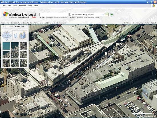
Pike Place Market in Seattle
The new Windows Live Local service also gives users new ways to identify where they want to go and map the best route to get there. Users will be able to point to any place on the map that interests them and immediately calculate directions to it. Now, even if the user doesn't know the address or name of a place — such as a park, shopping mall, parking garage, or other spot that is hard to identify by address or name — he or she can simply point, click, and get directions to that location. The new service also provides new driving direction capabilities, including step-by-step directions using bird's-eye or satellite views, identification of construction areas along a specific route, and several print options - such as print-only directions, the addition of notes to printed directions, and thumbnail pictures of each turn in the route. An updated version of Microsoft Location Finder is also available in Windows Live Local to help people using a Wi-Fi-enabled laptop, Tablet PC, or desktop PC to position their current location as a starting point to their search experience. According to Microsoft, the degree of accuracy "is usually within a few hundred feet of a user's actual location."
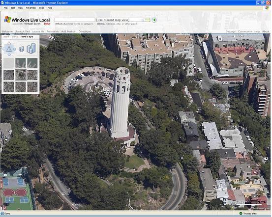
Coit Tower in San Francisco
Today's launch also offers users the ability to customize their maps by adding their own user-created "pushpins," which can be annotated with information about a location. Pushpins can be used to create itineraries for a set of activities and in all cases can be shared with others through e-mail, Web logs, MSN Spaces, or instant messages sent with MSN Messenger.
***
I talked about the launch with Angela Morrow, Product Manager for MSN Virtual Earth and Windows Live Local.
How does Windows Live Local relate to MSN Virtual Earth? "It is not a rebrand. Virtual Earth is going to remain as our mapping and location platform. With consumers we talk about Windows Live Local. With developers and our commercial customers, such as the Marriot Hotel chain, we talk about Virtual Earth, because that is what they use. Windows Live Local, the product that we just launched, is powered by the platform Virtual Earth."
For how long will Virtual Earth and Windows Live Local retain the label "beta"? "They will stay in beta until we feel that we have enough imagery. We feel that [the imagery that we have now] is not enough to take the beta tag off. We have several MSN services available [in different markets]; until we have better coverage we will keep the beta tag on. The usability we feel is pretty good, but we will continue to make improvements."
What are the sources of your imagery? "We have several different partners and they contribute different layers of the view. Harris provides us images at 15 meters per pixel. Pictometry provides us images taken from 4,000 and from 3,500 feet; those from 3,500 feet have a pixel size of 6 inches. In some markets we will not have Pictometry. With Pictometry we have a roadmap set up for areas that they will fly."
Are you on schedule? "Yes. When we launched Virtual Earth in July we had full satellite imagery for the United States and we announced that we would release new features every three to six months."
Besides what I've listed above, what other changes have you made? "We've changed and modified a lot of smaller things. For example, you can use your mouse to select a section and zoom in on it. Many people asked us for a quick way to zoom in and zoom out. From the directions perspective, Virtual Earth took you to the previous MSN Maps & Directions page. Now, instead, directions are fully integrated into Windows Live Local. You can right-click anywhere on the map to start or end directions (a search is also still available but not required). This is important especially when you need directions to places, such as stadiums, that typically don't have street addresses listed. Also, now you can switch from turn-by-turn directions to the bird's-eye view, so that you can see what a complicated intersection looks like."
What is your coverage outside of the United States? "We have worldwide coverage at 15 meters per pixel. We cannot discuss at this time what international markets we will roll into, but you will start to see them within six months. We will have roads and, where available, local search, satellite views, and bird's-eye view."
Will you release the API for Windows Live Local? "A few months ago we released the API for Virtual Earth and announced that we would make it available for non-commercial use (users have to keep the "What:" and "Where:" box on it). In the next few weeks we will release the API for Windows Live Local. The current API is good until December 31. Then all mash-ups will have to switch to the new API, but we are making sure that this will only take a minimal amount of code."
Book: GIS for the Humanities and Social Sciences
 GIS-Based Studies in the Humanities and Social Sciences, edited by Atsuyuki Okabe (New York: CRC Press, Taylor & Francis Group, 2006), hard cover, 328 p.
In principle, GIS can enhance studies in the humanities and social sciences, because all of the phenomena that they study occur in geographical space. However, to actually benefit from a GIS — or from any computer-aided method of analysis, such as statistical programs — researchers need to devote time to learning how to use it and what it can do. To assist them in this effort, a large group of Japanese academics carried out a six-year project entitled Spatial Information Science for the Humanities and Social Sciences (SIS for HSS) and funded by Japan's Ministry of Education, Culture, Sports, Science and Technology. Launched in 1998 with the establishment of the Center for Spatial Information Science (CSIS) at the University of Tokyo, the project ended in March 2004. Twenty months later, CRC Press just published this collection of articles from the project, edited by the project leader, Atsuyuki Okabe.
The project had two aims. First, to cull myriad fragments of spatial methods that had been developed mostly in the fields of economics, human geography, and archaeology; integrate them into a coherent whole; and develop them into practical GIS-based analytical tools. Second, to develop a spatial data infrastructure that would support research in these fields. To these ends, the project team was organized into three subject groups — focused on economics, human geography, and archaeology — and two technology groups — focused on spatial data acquisition and spatial data management.
Unlike the project team, the book's 19 chapters (following an introductory one) are organized into five parts: spatial data acquisition, spatial databases, tools for spatial analysis, applications of spatial analysis, and visualization. Each chapter includes many illustrations and a bibliography.
While a few of the chapters involve small amounts of math, on the whole the book is very accessible to a non-technical audience. Few, I suspect, will want to read the book straight through. I think, that most readers will browse the book and then read the chapters most relevant to their particular research challenges. They are all short (16 pages on average) and freestanding. Some awkward phrasing and syntax is mostly due, I presume, to the fact that the authors are not writing in their native language, as well as to uneven copyediting.
Chapter 2 discusses a software tool called STAMP, which combines the techniques of photo collage and hypermedia (hyper-linked multimedia objects) and integrates many photographs into a quasi-three-dimensional geographical space that can be virtually traversed. Chapters 3 and 4 discuss the use of laser scanners for acquiring spatial data on stationary and moving objects, respectively.
Chapter 5 deals with a historical population database and shows how to reconstruct historical population data from ancillary sources, especially old maps. Chapter 6 deals with a statistical database for urban areas and proposes a new iterative method for defining urban areas using GIS, called urban employment areas. Chapter 7 discusses the methods used in constructing a universal database for archaeological observations; outlines a new data standard, ISO/TC211, for spatial-data transfer among different research communities and GIS software; and proposes an object-oriented spatial database for managing archaeological data in terms of the Unified Modeling Language (UML). Chapter 8 shows how to locate tools for spatial analysis via the Internet. Chapter 9 discusses the spatial effect of infrastructural features on the distribution of events (e.g.: in Los Angeles public transport stations attract crime; in Istanbul mosques are usually located on hilltops) — and illustrates how to use a toolbox, called SAINF (available for free for download) to statistically analyze these spatial relationships. Chapter 10 demonstrates how to use another toolbox, SANET, also downloadable for free, for analyzing network spatial events - events that occur in a network or alongside a network.
The seven chapters in Part 4 are case studies of the application of spatial analysis in history, archaeology, sociology, housing economics, urban economics, and educational administration. The book's last three chapters focus on visualization. Chapter 18 shows a three-dimensional visualization method for historical studies. Chapter 19 deals with the visualization for "site assessment," often discussed in marketing. Finally, chapter 20 — the most abstract in the book — deals with the visualization of the perceived image of geographical space, a.k.a. a mental map, as in environmental psychology.
The very fact that this research was conducted by Japanese scholars and often deals with case studies in developing countries, such as a study of spatial pattern of settlement and migration in Cairo, Egypt, is refreshing — given the enormous preponderance of North American- and European-centric research in this field. Also stimulating are the connections that the book makes with art, as in the concept of collage, and the humanities. Finally, several of the studies focus on an aspect of GIS that is still very underdeveloped: the temporal dimension of geographic phenomena — such as the growth of cities over the course of the last century. In short, this book further enlarges the context and applications of GIS.
News Briefs
Please note: I have culled the following news
items from press releases and have not independently verified
them.
CONTRACTS & COLLABORATIONS
DeLorme, a developer of digital mapping, GIS, and data solutions, will be supplying its XMap/GIS Editor to Telephia, a company dedicated to providing worldwide coverage maps of cellular phone networks. Telephia plans to apply XMap/GIS Editor to its mobile fleet of drive test vehicles, collecting cellular phone coverage data. The company will use the software to route vehicles, track their progress by means of GPS receivers, analyze and manage the collected data, and display that data, in the form of coverage areas, against street level data and various aerial and satellite imagery sets.
XMap/GIS Editor offers full GIS functionality, including access to existing GIS data, import and export of ESRI Shapefiles, data creating and editing tools, and Web publishing of GIS data. XMap 4.5 includes an array of standard mapping features as well as access to GIS data that has been processed in XMap/GIS Editor.
Digital Data Technologies, Inc. (DDTI) has implemented Location-Based Response System (LBRS) road centerline and addressing data for Clark County, Ohio. The state of Ohio's LBRS initiative, led by the Ohio Geographically-Referenced Information Program (OGRIP), is improving the state's overall road inventory, including the identification of unreported roads and the updating of municipal road inventories that have been outside the realm of the Ohio Department of Transportation. Once counties establish this LBRS data, they are in a position to obtain additional roadway safety funding that may currently be unavailable.
Clark County initially began its LBRS project with DDTI to map landline and wireless calls to 9-1-1, and to clean and update the engineers' existing address database. Due to the highly accurate centerline data that was provided, Clark County was able to locate an additional 120 hazardous roadway segments that may qualify for additional roadway safety improvement funding.
The City of Fresno, California — the state's sixth largest city and its largest inland city — has selected MWH Soft's H2OMAP Sewer Suite Pro to replace its existing sewer modeling solution. The city's wastewater system serves more than 500,000 customers in the Fresno metropolitan area through 1,400 miles of sewer lines, ranging in size from 6 inches to 84 inches in diameter, and 15 sewer lift stations. The city plans to use H2OMAP Sewer to develop expansion and rehabilitation strategies for its wastewater infrastructure — changes designed to best accommodate continued community growth, maintain regulatory requirements, and improve operations.
H2OMAP Sewer is used by municipal engineers, consultants, and planners worldwide to create detailed models of sanitary and storm sewer collection systems. These models enable users to assess the effect of new developments, zoning changes, and other additional loads on system flows. They also help pinpoint current and future problem areas; determine how best to restore capacity lost to infiltration and inflow with the least rehabilitation; predict unwanted overflow events and backups; develop improvement alternatives; meet environmental regulations; and enhance community relations.
ACA MultiVision has entered a strategic partnership with Mobile Video Services, Inc. that will provide property appraisers, law enforcement and emergency management agencies, and GIS users with an imaging solution that combines aerial, oblique, and street-view images linked to address points and property appraisal CAMA data. Measurements of structures, facades, roads, and other elements can be made directly on the oblique aerial photo while viewed on any standard PC.
Mobile Video has served local governments for more than twenty years collecting and field-verifying both geographic and property data. Detailed services include street centerline verification and correction, collecting X-Y geo-reference points for each unit address and every structure within, verifying CAMA data, and capturing street-view images.
AAMHatch, an Australian surveying and mapping firm with a strong presence in the Asia/Pacific region, has selected Intergraph Corporation's Z/I Imaging DMC (Digital Mapping Camera) to streamline its aerial imaging, mapping, and remote sensing operations. AAMHatch will go into production with its Intergraph DMC in early 2006, providing both small and large-scale digital images to customers. The DMC's streamlined digital processes allow for a more integrated and effective production process with a quicker turnaround of production-ready data, facilitating the route to market for both AAMHatch and its customer base.
PRODUCTS
ADC WorldMap, a provider of geographic data, has released ADC WorldMap Digital Atlas Version 5.0. Among other updates, the new product provides national and sub-national boundaries for the entire world. In addition to including 241 country and more than 3,220 level 1 boundaries, the new atlas provides enhanced city data arranged by population. The data also has been updated to include capitals of the world.
Open Spatial Inc has released Munsys Query 9.3.2, which permits engineers to retrieve GIS information from Oracle Locator or Spatial directly into Autodesk's CAD products — including AutoCAD, Autodesk Map 3D, Autodesk Land Desktop, and Autodesk Civil 3D software. Attribute data from Oracle can also be retrieved to the drawing as Object Data. The same seamless Oracle database that is used by GIS users can also be accessed directly (read only) to create CAD drawings containing the latest spatial and attribute information. This information can then be manipulated for design purposes using standard AutoCAD functionality.
Version 9.3.2 improves upon the initial release by extending the query functionality beyond a Munsys schema to any Oracle schema that contains SDO_GEOMETRY columns. Graphical data can be retrieved as native CAD entities and attributes can be retrieved as Object Data. Prior to Munsys Query, engineers would typically ask the GIS department for a copy of the relevant data, but it would quickly become outdated. With Munsys Query, engineers can access the data directly whenever they want to refresh the background information.
Hemisphere GPS, a designer and manufacturer of GPS products wholly owned by CSI Wireless, has introduced a new heading sensor module for Original Equipment Manufacturers (OEMs) that features Hemisphere's high-performance Crescent GPS technology. The Crescent Vector OEM module, a printed circuit board, is a complete GPS compass and positioning system designed primarily for the marine market but also applicable to other markets, including agriculture and machine control. The integration of Hemisphere's Crescent GPS technology enables the Crescent Vector OEM module, in comparison with competing products, to deliver higher update rates, noise-reduced raw measurements, more memory, more processor capacity, lower power consumption, and more advanced applications and sophisticated configurations.
Crescent technology also enables the module to simultaneously employ multiple front-ends — enabling tighter coupling of measurements from separate antennae for use with heading-based products. Users will achieve greater accuracy and stability, due to Crescent's more accurate code phase measurements, improved multipath mitigation, and fewer components. The Crescent Vector OEM module enables OEMs and integrators to choose their appropriate power supply and communications translation. In addition to its discrete Crescent GPS components, the module integrates a single-axis gyro and a tilt sensor onto a small form factor. Its heading accuracy ranges from 0.1 degrees (rms) at 2.0-meter antenna separation to 0.25 degrees (rms) at 0.5-meter antenna separation. It provides heading and positioning updates of up to 20 Hz, and delivers positioning accuracy of 20 centimeters 95 percent of the time when used with Crescent's L-Dif differential GPS (DGPS) receiver product, and 50 centimeters 95 percent of the time when used with WAAS (Wide Area Augmentation System) DGPS.
The Crescent Vector OEM module also features Hemisphere's COAST software that enables Hemisphere receivers to utilize old DGPS correction data for 40 minutes or more without significantly affecting the quality of positioning. When using COAST, the Crescent Vector OEM is less likely to be affected by differential signal outages due to signal blockages, weak signals or interference.
Leica has released the SmartRover, a cable-free all-on-the-pole RTK GPS system that weighs only 2.8 kilograms and consists of the Leica SmartAntenna ATX1230 and the Leica RX1250 Controller. The RX1250 includes Windows CE and Bluetooth wireless technologies, which facilitate direct contact to the office via the Internet to upload/download data. With its integrated CF-card, data can be seamlessly exchanged with Leica System 1200 instruments to provide full X-Function compatibility. The SmartRover also includes SmartTrack and SmartCheck technologies and is fully compatible with the Leica SmartStation, a total station with integrated GPS. Use SmartStation to position your total station, and then transfer the SmartAntenna to continue RTK GPS surveying with the all-on-the-pole-solution SmartRover.
LeadDog Consulting, LLC has released geographic databases of the streets of Abuja and Lagos, Nigeria to support asset-tracking, government, and commercial GIS applications. Designed to help companies track their assets and provide accurate base level mapping, LeadDog's product provides numerous vector layers and attributes such as: streets at 1:10,000 scale, street names, street classifications, points of interest, landmark polygons, and administrative boundaries to block level. Abuja City Streets and Lagos City Streets are available in all major GIS formats.
CONFERENCES
The Urban and Regional Information Systems Association (URISA) and the National Emergency Number Association (NENA) are jointly sponsoring the First Annual Geospatial Integration for Public Safety Conference (GIPSC), which will take place 2006 April 10-12 at the Renaissance Hotel in Nashville, Tennessee. Designed for 9-1-1 professionals, GIS professionals, addressing coordinators, and incident management and emergency response specialists, GIPSC will address mapping and addressing in public safety and emergency management. The conference program, exhibitor information, and registration form will be available in late January.
PEOPLE
HDM, a company specializing in GIS and location-based services, has appointed David L. Chadwick to the position of Senior Vice President and General Manager of its new Government Solutions Division (GSD). Chadwick brings to HDM extensive experience leading the development of advanced Internet and software technology solutions in the commercial and public sector. He was previously CEO of Priority Telecom, NV, Amsterdam, a $120 million public European technology and telecommunications company, focused on B2B corporate voice and network data services. Before that, Chadwick was Chief Operating Officer for telecom startup Cignal Global Corporation of Cambridge, Massachusetts, helping it to grow to $50 million in annual revenues prior to its acquisition by UPC. As the Senior Manager of National Infrastructure Programs at Raytheon Corporation in Lexington, Massachusetts, he led Raytheon's business unit charged with identifying commercial opportunities for the deployment of dual-use technologies within developing countries.
Chadwick retired from the U.S. Marine Corps in 1997 as Colonel and Deputy Chief Information Officer (CIO). His major military assignments included command of the Marine Corps Tactical Systems Support Activity and the Naval Information Systems Management Command within the Office of the Assistant Secretary of the Navy for Acquisition and Development.
Overwatch Geospatial Operations, formerly Sensor Systems, has named Michael Schwien as its new Chief Financial Officer (CFO). A Certified Public Accountant, Schwien has an extensive background in corporate financial management. In his 19-year career in corporate finance, he has gained a thorough working knowledge of accounting operations, strategic business planning, budgeting, corporate financing, and SEC reporting. Most recently, he served as CFO of VitalSpring Technologies Inc., a private company that provides healthcare-related business intelligence and data warehousing services to Fortune 1000 organizations. Prior to that, Schwien was Vice President and CFO of VCampus Corp., a publicly-traded eLearning company. He has a Bachelor of Science in Business Administration from the University of Colorado in Boulder.
Schwien joins Overwatch as the RemoteView product line is poised to become the primary platform for merging sources of intelligence across multiple agencies of government. It is currently the leading software for imagery visualization and geospatial analysis within the defense and intelligence communities, handling massive image data sets of multiple gigabyte size for rapid visualization and processing. RemoteView is a key component of the Overwatch Intelligence Center (OIC) created when Overwatch Systems integrated the resources of four companies, including Sensor Systems. The OIC is a suite of integrated geospatial and fusion software tools for the defense/intelligence community. It focuses on providing situational awareness by enabling analysts to generate relevant, actionable intelligence faster and more effectively for the warfighter, first responder and decision-maker.
Leica Geosystems has appointed Valerie E. Richardson to the newly created position of vice president, strategic marketing and business development, Americas Region, as part of a strategic initiative to enhance product marketing and planning in the Americas.
Richardson assumes responsibility for providing leadership in all end-to-end strategic marketing areas, including product marketing, software development center, Web tools marketing, marketing communications, customer care and order entry, channel marketing, management of partners programs, sales and marketing training and market intelligence for North and South America. She is based in Leica Geosystems' American headquarters in Norcross, Georgia.
Prior to joining Leica Geosystems, Richardson was vice president, marketing and business development for a division of Invensys plc, a multinational supplier of electronic and electromechanical systems and components for industrial, commercial, and residential markets. She holds an M.B.A in Finance from North Central College, an M.A. in Industrial/Organizational Psychology, and a B.A. in Journalism from Drake University.
OTHER
The second draft of the Street Address Data Standard has been posted for public comment by the geospatial community. The comment period for this version of the draft standard will end on January 16. The objective of this effort has been to create a single street address data standard that consists of four parts: content, classification, quality, and transfer. The Federal Geographic Data Committee (FGDC) in April 2005 accepted a formal proposal from the Urban and Regional Information Systems Association (URISA) to create this standard. The standard is intended to provide a statement of best practices for defining street address data content and class, set standards and tests of street address data quality, and facilitate exchange of street address data. This revision of the draft standard reflects the comments received from the first draft, additional original work that further defines address elements and classes, an approach to devising address data quality tests, and the creation of a detailed XML schema for address data exchange. URISA and its partner in this effort, the National Emergency Number Association (NENA), invite everyone to review the draft and provide comments.
The results of this collaborative process will be submitted through the FGDC's formal standards approval process. If they are accepted, the U.S. Census Bureau will maintain the standard as theme lead for the Federal Subcommittee on Culture, Society, and Demographics. URISA Past President Martha Lombard, GISP, former URISA Board Member Hilary Perkins, GISP, URISA President-elect Ed Wells, GISP, Carl Anderson, and Sara Yurman are leading this effort on URISA's behalf.

GIS
Monitor Back Issues
Advertise with Us
You
can reach more than 17,000 GIS professionals every issue by
sponsoring GIS Monitor. For more information, email us.
Contact
Please
send comments and suggestions to:
Matteo Luccio, Editor
GIS Monitor
Ultimate
Map/GIS Directory — Your search is over!
GIS Monitor is published by:
GITC America, Inc.
100 Tuscanny Drive, Suite B1
Frederick, MD 21702 USA
Tel: +1 (301) 682-6101
Fax: + 1 (301) 682-6105
Subscribe/Unsubscribe
If you wish to subscribe or unsubscribe visit our subscription
page.
|