|
Letters, Points of Interest, Week in Review, Back Issues, Advertise, Contact, Subscribe/Unsubscribe
EDITOR'S NOTE And, one more note on my colleagues. I often get mail asking about the size of the staff that produces GIS Monitor each week. I'm pleased to report that it's big enough. Two key players behind the scenes, Allen and Jackie, are responsible for getting GIS Monitor to you for free, and editing my words, respectively. These roles are woven into their other responsibilities at Professional Surveyor. Since we do not list the "production staff" regularly, I want to take a moment to salute their efforts in bringing a quality GIS Monitor to you each week. Adena
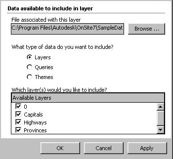
AUTODESK ONSITE DESKTOP 7: A REVIEW Before delving into the product, note that OnSite 6 (there was no "desktop" in the name for version 6) was delivered with the Autodesk's Map Series, where it joined Autodesk Map and Raster Design. With version 7, Autodesk decided to place OnSite Desktop in both the Map and Civil Series and to make OnSite Desktop available as a stand-alone product. This desktop visualization software is ready to stand on its own. Recall that when OnSite 6 launched with the Map Series in May, I was a bit hazy about its positioning. However, when I saw OnSite Desktop 7 for the first time in October, I was very interested. Now, having had my hands on it, and having seen it at Autdodesk University, I pronounce it first-rate GIS visualization software. The InstallA very thin, non-descript "Read This First" card contains some key warnings about the installation. The first warning: the .NET framework will be installed if it is not already available. Remember, this is Autodesk's first .NET offering, and if not the first, then one of the first, in the GIS marketplace. The second warning: Internet Explorer 5.5 will be installed if it is not already. I thought I was running IE 5.5, but the CD installed it anyway. The card does not note, but I learned from experience, that there are no options to the install; it's all or nothing. I needed only to confirm that I was performing a stand-alone rather than a network install. Another card, "Before You Install," explains about "renderers" (as they are called in the installation process) or "graphics engines," as they are called in the document. Autodesk recommends DirectX 8.1, which is supported by newer cards, but I opted for the OpenGL option as I'm running OnSite Desktop 7 on a several year-old Toshiba Tecra 8100 laptop with Windows 98 SE. My 8 Mb of VRAM puts this machine at the low end of the supported hardware configurations. Once I had the install complete, I ran a patch that was made available after release earlier this fall. That ran smoothly. Then things got confusing again. Despite a promise on the "Read This First" card that an Authorization Wizard would display on start up, it did not. An authorization reminder, however, did. It instructed me that the "Read This First Card" explained how to get an authorization code. If the information was there, I could not find it, so I ran the product as a 15-day evaluation. (I learned at Autodesk University that I was supposed to visit a website to register, something that was not clear on the "Read This First Card." To be fair, I was working with the stand-alone version. Most Autodesk users will likely receive OnSite Desktop as part of the Map or Civil Series, which I'm told has an automatic registration.) The Interface
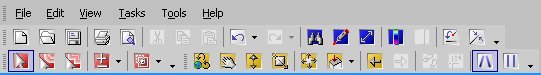
The first thing I noticed, after the blue work window, was the OnSite Desktop 7 toolbar: it's tri-colored with red, yellow, and blue icons. Red are for selecting objects (note the terminology parallels AutoCAD's), yellow are for navigation (zoom, pan, orbit and others), and blue ones call up task panes such as layer, information, and search. By default the task panes pop up docked on the right side of the screen. They can float or be docked on the left, too. These panes include drop down lists, check boxes, and more tools.
At first I found it a bit challenging to remember whether the tools are in the main tool area or on a pane. For example, my personal favorite of the zoom tools, "zoom layer extents," is not on the main tool bar, but on the layer pane. However, once I got used to layer-related commands living on the layer pane (left), I stopped having trouble. The interface is uncluttered and unintimidating. My feelings on the interface were confirmed when I sat in on a session at Autodesk University by the Product Designer, Andy Pease. Product Designers are in charge of the look and feel of the product. Pease told a great story to help explain how the OnSite team determined how OnSite Desktop 7 should look. He talked about rebuilding a fuel pump in an old Land Rover. It would be easy, he argued, if someone laid out all the right tools for him before he walked to the driveway to get to work. How frustrating it is not the have the right wrench! It stops the flow of work! That's the logic that the team brought to OnSite Desktop 7. The goal was to lay out all the tools needed to perform a particular task on its task pane. If you pick up a copy of OnSite Desktop 7, visit the Autodesk University website to see if you can find a copy of Pease's paper: "What's New with Autodesk OnSite Desktop" (Course ID: GI43-1). Another note on Pease's class: unlike most of the other lecturers, he provided a very readable paper, complete with graphics, to take home. The printed PowerPoint slides from other instructors were far less valuable, at least to me. The Manual The printed documentation begins with a reminder that this product is designed to work in tandem with other Autodesk products. Chapter Two outlines a series of workflows where Yoshi, Steve, Maria, and others weave OnSite Desktop with data from MapGuide, Land Development Desktop, Autodesk Map, Civil Design, OnSite View, PowerPoint and Oracle. Chapter Three highlights key terms and ideas, and outlines many of the data types supported (DWG, Oracle Spatial, Autodesk MapGuide SDF, SHP, ESRI coverages and E00, MicroStation DGN, and MapInfo MID/MIF among others). Chapter Four is the heart of the manual. It includes twenty mini-tutorials that cover specific tasks using sample data.
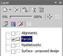
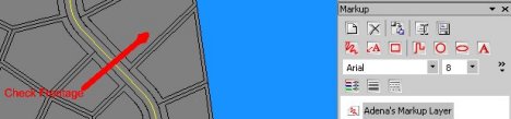
I found the manual effective, though at times the small black and white icons in the book were hard to find on the color screen. The black and white graphics were also hard to decipher. That said, Autodesk does provide a full color PDF of the document with the installation and on its website. I applaud the effort as a compromise between no manual and an expensive color one. I ran through a few of the tutorials in no time at all. I added new layers, draped a parcel layer over a surface, brought in a LandXML file, and added some markups(above). The Program While I love the interface and the broad functionality, some aspects of OnSite Desktop 7 are a bit counter-intuitive, at least at first. For example, to adjust the order in which the layers draw, you do not use the default layer pane itself. Instead, you must click on the pane's Views tool. In that pop-up, you can rearrange the layers. I found that it's quicker to do this with the layers turned off, otherwise there is a delay as each one draws, at least on my graphics limited machine.
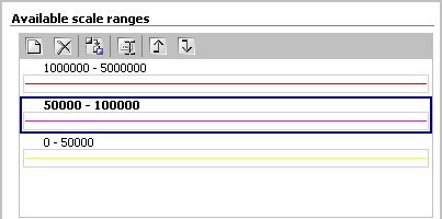
As I dug deeper into the functionality I found what were, at first, some rather complex dialogs. But, as I thought about the "tools when you need them" idea, they made more sense. The Style Explorer is used to assign symbolization for layers. Unlike other programs I've used, all of the layers are available for symbolizing from the dialog. The upper right pane is used to set scale dependence, while the lower one includes tools to define value ranges and choose color ranges for thematic maps. One innovation I've not seen elsewhere: it is possible to set different symbolization for different scales. In the example above, at large scales the sanitary sewers are yellow; as the scale gets smaller and covers a larger area, they change from pink to red. There's another nifty symbology function. Symbols can be built from simpler symbols. I built a "grey road with yellow striped lines" symbol from a yellow dotted line symbol on top of a fat gray line symbol. It looks great!
Linking to external databases is done via a dialog and is fairly simple. Working with DWGs is not as slick as it might be. OnSite Desktop 7 is "at its best" using layers with a single data type (point, line, polygon, or text), though it can support a layer with different types. A DWG typically will have many AutoCAD layers, which may or may not contain the same type of AutoCAD object. In OnSite Desktop 7, the Data Explorer is used to filter (right) the DWG by layer, query, or theme (from Autodesk Map). Still, I was frustrated that once I did filter the DWG to a single type of data (lines), I could not find a way to resymbolize the data. That is, if the linework was red in the AutoCAD DWG file, I could not render it in, say, yellow.
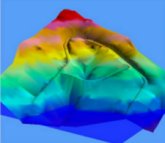
What's Hot? Beside the elegant interface, OnSite Desktop 7 supports key data types and shows good speed (on other machines, not mine!) as well as a few other goodies like cut and fill analysis, flood analysis and animation. The draping is just great. Autodesk University attendees drooled over that particular function, encouraging Autodesk to put in Map and Land Desktop. The flooding tools are simple to use and look great on screen (right). The animation tool, which allows driving down a linear feature, is simple to use and very impressive. Those who work in land development will love the cut and fill estimation tools that compare an existing plan with a proposed one. Symbology is excellent; I particularly appreciate the ability to build complex symbols by layering simple ones. Bottom Line This is a huge leap for Autodesk over OnSite 6, and a terrific first step into the world of GIS on .NET. Users will have to take some time to appreciate OnSite Desktop 7's new interface, but I think most will pick it up quickly. Again, let me emphasize, this product is 100% about visualization. It does not make new data, except for simple buffers and markups (which can be exported). It's my belief that the choice to keep data creation out will keep the product accessible and focused. That said, GIS third-party developers are no doubt ecstatic. I understand that virtually all of the GIS developers at the one-day Autodesk University Developer Conference had a close look at OnSite Desktop 7. Look to them for future enhancements.
ONE STEP FURTHER: ONSITE DESKTOP ON THE TABLET PC First, I had to get the basics on the Tablet PC. A new primary application, Windows Journal, is basically an all-purpose writing tool. Scribble on its lined paper using Tablet PC "ink" and it responds to how hard you press. If you scribble a note just for yourself, there's no need to perform character recognition. If the "scribble" is intended for others, you select the text and the application will do its best to turn it into digital text. My very poor handwriting was not too well received, but Hobson told me that you learn to "behave" rather quickly when writing material that will eventually be converted. At about 3 pounds, the Tablet PC was a bit heavy, and the screen had quite a bit of glare (we used a Fujitsu). I had to be careful to hold it at the correct angle for use. Battery life is still limited to 3-5 hours due to a power drawing chip and screen. But as I noted last week, the battery should improve in time. Still, it felt really nice to write on! Hobson pointed out that many other issues were "solved" with the Tablet PC: it's got a built in wireless connection, a big screen, and huge hard disk (the one we used had a 40 GB drive and 512MB RAM). And, since the Operating System is a variant of Windows, Window XP Tablet Edition to be exact, there is no learning curve for many users, unlike many handheld devices. Hobson suggests the Tablet PC may bring GIS to those who've thus far pushed it away. The first uses may well be mapping oriented. Next up: salespeople and traditional businesses. Then, because of the Tablet PC's ability to display meaningful graphics (unlike a handheld), traditional businesses may be more apt to integrate maps into their daily mobile work. I asked Hobson what it took to make OnSite Desktop 7 run on the Tablet PC. He said he was pleasantly surprised when a programmer sent him 3 DLLs (dynamic link libraries, little bits of code) to copy to an existing "regular" installation already on a Tablet PC. Because this is .NET you literally copy the DLLs to the correct location. There are no need for registry entries! Wow! Those three DLL's added some key functionality to OnSite Desktop 7. One allowed OnSite Desktop 7 to understand "real" inking. Here's how Hobson illustrated the difference between OnSite Desktop 7 without ink and with it. He started up OnSite Desktop 7 and set it up to create some markup. First we used the stylus as a mouse in OnSite Desktop 7, just as you might on a desktop computer. It was horrible, very slow to recognize the points and not particularly accurate. Then we used a magic "inking" button that one of the DLLs enabled on the interface. That made my redlining as smooth as . . . ink! Why? Because it was ink! Essentially, the operating system captured my inking, then via the application programming interface (API), immediately passed it on to OnSite Desktop 7. And, that tool required just one DLL. It was like magic! The other two DLLs enable voice control and support of "gestures" in OnSite Desktop 7. Gestures are pen motions for commands. Unlike older tablet hardware where you wrote the gesture right on the screen (I recall doing this in a demo for MicroStation Field years ago), Tablet PC gestures are performed on a special "gesture" area, a floating pane, much like the graffiti area of a Palm OS device. Those three enhancements allowed Autodesk to provide OnSite Desktop 7 to an airport for a pilot project. There were three tasks the staff needed to perform: data capture, working with an operations center, and basic facilities management. The data capture used the markup tools to draw evacuation plans over large images (10 Mb). The wireless capabilities meant that should an evaluation plan change, the plan could be updated graphically at the point of work (the emergency), then immediately sent back to the coordinators in the operations center. The ability to access DWG and other CAD files meant that facilities crews could easily compare what was on the map (often a CAD file) to what they saw as they toured the airport. In the future, a Tablet PC with higher bandwidth might tap into live camera feeds to keep an eye on various locations in emergency situations. A few things are worth noting here: .NET enabled OnSite Desktop 7 to move to the Tablet PC with a minimum of effort. The Tablet PC itself is quite a powerful computer, and an easy one to work with right away. And, the Tablet PC is "smart" enough to know that if it's grabbed out of its docking station, is should immediately search for a wireless network. These features demonstrate that it has great potential as a field mapping platform. If battery life and weight can be conquered, this hardware just might change everything.
MAPINFO'S COMPETITIVE OVERVIEW WEB SEMINAR The discussion centered on MapInfo Pro vs. ESRI's ArcView and ArcInfo. The main issues that were explored included MapInfo's logo compliance to Microsoft operating systems, an assertion that MapInfo Professional is actually comparable to ArcInfo, not ArcView, and a suggestion that much of the content of ESRI's extensions is in MapInfo Pro. A good deal of time was spent on a slide comparing MapInfo Pro to ArcView 3.x. One slide highlighted key moments in MapInfo history, but showed a huge break between the launch of ArcInfo and the release of ArcGIS 8. No intermediary versions of ArcInfo were indicated. The valuable part of the session, hosted by MapInfo Product Manager, Moshe Binyamin, highlighted the strengths of MapInfo. The bottom line on these types of comparisons: do it yourself. First, define what you need to do with a GIS and identify what data is used. Then, get an evaluation copy of the products of interest and see how well/easily they do those tasks. Next, make your decision. (If a company will not provide an evaluation copy, I'd argue they are not really interested in your business.) According to the presenters, a taped version of the seminar will be available on the MapInfo website after the first of the year.
MORE (LESS, ACTUALLY) ON GEOGRAPHY AWARENESS WEEK "Geography Awareness Week is alive and well. If you look at our website you'll find this year's project, which highlighted America's Public Lands. "This year and last year we focused our Geography Action program on conservation issues. The program has been expanded and now runs from spring through the fall. This year we participated in the Public Lands trek and there was significant media coverage of that in July and September. I would be happy to put you on the media list for next years Geography Action program so you will find out what we're doing." My take: Geography Action has eaten Geography Awareness Week. Perhaps more disturbingly, geography may be eaten by conservation at National Geographic. Don't get me wrong, conservation is a good thing, but as a geographer I think it is important for this venerable organization to loudly proclaim that "geography matters" at least once a year.
LETTERS "As always I find loads of interesting stuff in your GIS Monitor. I have been involved with Safe on the MapGuide plug-in and the thing that I don't think is widely appreciated is that this plug-in is implemented as an OLE DB provider serving simple features (as per the OpenGIS Simple Features for OLEDB/COM Specification). I think that Autodesk and the MapGuide team should receive respect for implementing a standards-based mechanism for plugging in additional data sources." The editor replies: Part of getting the word out that a product implements an OpenGIS, or any other specification, falls under marketing. The respect, of course, has to be earned in the community. As many readers know, I work for the Open GIS Consortium as a consultant. � Several readers wrote to comment on Carol Bartz' prediction about the future of printing. Her comments were summarized this way in last week's issue: "analog or paper data . . . adds no value to data, while keeping the data digital does." Lynn Allen later put it this way: "Printing stops the intelligence process." FM (that was the signature) put it bluntly and suggested looking back in time: "That is, of course, nonsense . . . The same comments were made some 20-30 years ago when auto-carto time was ongoing . . . In every case the well-educated and trained human brain (knowledge and expertise) is needed to make decisions based on cognition no matter if the inputs are coming from analog and/or digital data . . . "But, the amount of value-add to be produced by digital tools like Autodesk Map or ArcView GIS is much higher compared to manual modeling procedures . . . In any case, have a look at cartographic sources from the 70s!" Jeff Thurston wrote to argue that there will be not less, but more printing in our future: ". . . there will be a resurgence for hardcopy maps. They are used by far more people in the world than a digitally distributed map and likely always will be. Ideally both digital and hardcopy will exist together-good GIS making good maps period, whatever the medium. The printer manufacturers need to focus on the community level and developing products kids can produce to share on the street or people can talk about in community halls coupled to visualizations, then couple the two together. "If anything, our digital technologies have provided the impetus for people to create, use and distribute their own hardcopy maps-and I think that is pretty neat." � Bob Gurda, Assistant State Cartographer at the Wisconsin State Cartographer's Office, added more information about the maps of the state that I suggested would make fine gifts: "Thanks much for the 'plug' for the Wis. Land Cover Map (which was ACSM's 'Best Thematic Map' in its 2000 Map Design Competition) and the Landscapes of Wis. Map . . . "I'm curious to know how you found about the article, since I hadn't known myself that it was out on the Web." The editor replies: I found it in my daily search for nuggets of news relating to GIS and mapping. If readers find such interesting tidbits, please share them with me! � An anonymous reader wrote to comment on the interesting response I received from the Interim VP of GIS at Autodesk when I asked about metadata support. "I think you know metadata is one of the great divides between 'CAD departments' and 'GIS departments.' In the AEC industry it seems to be a HUGE opportunity for improved efficiency, but what a hill to climb in changed business practice. I see so little documentation among CAD drafters it is enough to turn the stomach thinking about all the resources being wasted and the long-term impacts. . . In the interim, I think the main reason GIS people truly call CAD 'dumb' is there is rarely any metadata."
POINTS OF INTEREST � As snow hits the East Coast, GIS is touted as one of the new technologies aimed at making streets safe and saving money. I heard about spots on the local cable news and several articles in local papers. Local use of technology for crime fighting is also a hot topic. I wonder if these stories are being reported in lieu of hard facts about the use of GIS and other technologies for Homeland Security? � CNN argues in a spot on TV (thanks to my parents for passing it on) and an article that no one has heard of NIMA. In our industry, I argue that quite a few of us know about the National Imagery and Mapping Agency that was built six years ago from the Defense Mapping Agency (DMA) and other mapping groups across the federal government. A former CIA photo analyst argues that adding a CIA satellite imagery analysis group to NIMA was a bad idea: "It creates a corporate culture that does not encourage challenging prevailing views and wisdom," he said. Retired Air Force Lt. Gen. James Clapper, NIMA's director, of course disagrees. � AT&T;, IBM, and Intel announced a new company, Cometa Networks, that plans to set up more than 20,000 wireless access points in the U.S. by the end of 2004. "WiFi has very high bandwidth and short range, while 2.5 and 3G cellular are lower bandwidth services designed to support data services on the fly," said Theodore Schell, chairman of Cometa Networks and a general partner of Apax Partners in the New York Times. How the two will compete is still unclear. How big is the market? Another article, from the same paper, cites the business challenge of making money from Wi-Fi. Of an estimated two million potential Wi-Fi sites in public places like cafes, only about 3,000 have been installed, according to Sky Dayton, founder of Boingo. � The New York Times (free registration required) reports that on January 15, Lufthansa will begin offering Internet connections on a single Boeing 747-400 that flies daily between Dulles International Airport and Frankfurt. The service will be free for the first month. British Airways will introduce a similar system between London and New York in February costing $32 per flight. SAS will follow. Continental will use a simpler, cheaper system-JetConnect-that puts a server on the plane which connects to the Internet every 15 minutes, but costs only $5.99 per flight. I'll let you know when GIS Monitor is first sent from a plane. Last week, GIS Monitor was sent from a wireless network at Autodesk University. � Ever been annoyed by pop-up ads on the Internet that vaguely look like warning messages from your computer? While some of us can tell they are fake, less savvy users can be innocently drawn to websites. The good news: one company creating these ads, Bonzai Software, is being sued. � A technology used for military communications is slowly moving to civilian life according to an Associated Press article. Mesh networking is a type of "self healing" network that does not rely on fixed transmitters, but rather uses devices in the network to propel a message forward. Used widely in the military, because soldiers are connected as soon as they turn on the radios, several private companies are developing and selling the technology. There are downsides: each participant "donates" battery time to make the network work, security is low since messages literally pass through many devices on the way to their destinations, and a certain "density" of users is required for effective use. � A new twist on spam: don't block the bad guys, make the good guys pay! A New York Times article highlights a new tactic against spam. In one solution, those with legitimate mail embed a haiku (a Japanese form of poetry), which acts a "key" to mail software at Internet Service Providers. The catch: the haiku costs money and essentially validates that the mail is not unsolicited spam, but solicited, opt-in mail. Violators who lie are subject to fines. � According to an article in the New York Times, Google has turned into a key marketing tool for small businesses. The theory goes that unpaid results are "objective" and worth quite a bit. For one small player a free Google placement guides 85% of business to its vacation website. I find this interesting since I found a paid placement on Google Groups for a GIS tender website recently. � After Kodak shut down its CitiPix imagery sales recently, I began to hear a series of radio ads for "InfoImaging," Kodak's brand for intelligent imagery. Kodak clients, including Disney and hospitals, explain how Kodak imaging solutions help their businesses. Then the voice-over asks how InfoImaging can help your business. � According to the Inquirer (UK) Autodesk this week formally stated that it's illegal to sell licenses of its AutoCAD product on eBay. The company has very strict licensing agreements that make it very difficult to move a license from one owner to another. � ODT, a company which made a big deal when its map was used on an episode of TV show The West Wing a few years ago, is making a big deal about former President Jimmy Carter using one of its maps on his trip to pick up his Nobel Peace Prize. The Hobo-Dyer map, an equal area map, highlights the 68 countries where the Carter Center has worked since 1982. � The good people of San Francisco will not be able to ride their Segway Human Transporters on the sidewalk. The city supervisors voted to ban it from the pedestrian turf, protecting the elderly, the blind, and those with baby carriages. The mayor has three weeks to consider a veto. I have mixed feelings. I like to ride my foot-powered scooter on the sidewalk, but recoiled in horror when my nephew was nearly run down by a bicycle on the sidewalk near my house. � The BBC reports that two professors from Dartmouth College have figured out a way to create a DEM from several oblique images of the same scene. The method requires at least three digital photographs of the region, from different vantage points. One challenge: the images must be taken from a hillside adjacent to the area not below it. After matching target locations on each image, some 50 or 100, a mathematical algorithm does the work. Next year, two students will test the method against traditional ones in New Zealand. Stay tuned! � Wired reports Australia's highest court this week gave a businessman the right to sue Dow Jones, publisher of Barron's based in New York, for defamation for an article published in the United States and posted on the Internet. � Looking for educational games for the kids for the holidays? Sherston Software's new program The Map Detectives looks promising. Junior detectives use maps to solve burglaries in Europe. The computer game also comes with hard copy maps and is aimed at 3rd-8th grade students.
� Announcements The City of Philadelphia has been awarded a $50,000 grant from ESRI to outfit the Managing Director's Office, Office of Emergency Management's Mobile Command Post 1 and Emergency Operation Center with GIS capability. URISA will be holding a conference from July 20-22, 2003 at Portland State University in Portland, Oregon on the subject of public participation GIS. Accruent, Inc. a provider of enterprise contract management solutions, announced it has agreed to acquire the assets of Vectiv Corporation, a provider of enterprise store lifecycle management solutions. "Vectiv has been first to build an application that blends location-based services, GIS mapping, collaboration, with financial-grade security into an Internet-based solution," says Accruent, Inc. CEO Mark Friedman. An article appeared about Vectiv's location work a year ago April. The Open GIS Consortium, Inc. (OGC) announced that it is offering new classes of associate membership for local, state and provincial governments. Government Agency State/Province and Government Agency Local/Other Associate Members are granted non-voting membership in OGC's Technical Committee and have access to all written and electronic Technical Committee communication. Membership benefits include the ability to participate in Technical Committee working groups and subcommittees as well as in OGC Interoperability Initiatives. Thales Navigation and RadioShack Corporation announced that RadioShack will carry the Magellan line of handheld GPS receivers as its exclusive GPS product offering in select stores this holiday season. Debra L. Moose, 44, was honored Dec. 3 for her outstanding contributions to the defense work force during the 22nd Annual Department of Defense Disability Awards Ceremony in Bethesda, Maryland. A deaf cartographer in the Digital Nautical Chart area NIMA in Bethesda, Moose was recognized for being "one of the few individuals who understand all of the process steps for DNC maintenance." AirPhotoUSA, LLC, announced an agreement that enables the integration of AirPhotoUSA's, high resolution, seamless color orthoimagery, to NewReach's Web-enabled real property data and mapping solutions. ESRI is making its Live Training Seminars available as Web Workshops. There are 13 hour-long workshops currently available, and more will be added to the Virtual Campus regularly. Webraska and partners demonstrated a multimedia in-car LBS and wireless navigation solution, as part of the COSMECA project, funded by French Ministry of Industry and Economy, at a tourism conference in France. LocatioNet, Inc., the developer of a comprehensive integrated platform for the delivery of LBS for the wireless market, has entered into a joint marketing agreement with Cambridge Positioning Systems Ltd (CPS), the UK developer of Enhanced Observed Time Difference (E-OTD) technology, to market the benefits of high accuracy positioning services to wireless operators in Brazil. � Contracts and Sales Geographic Data Technology, Inc. (GDT) announced a new three-year agreement with Risk Management Solutions (RMS), a provider of catastrophe modeling solutions to the global insurance and reinsurance industry. The agreement will allow the continued integration of GDT's geographic databases into RMS risk management products and services. NovaLIS Technologies, along with business partners Valcura International, GDS & Associates, and ESRI Canada, won a major contract with British Columbia Assessment to implement its state-of-the-art, Computer Assisted Mass Appraisal system in the province. Beyond 20/20 has been awarded a contract to supply its data dissemination software to the U.S. Census Bureau. In partnership with leading solutions integrator CENTECH GROUP Inc., and GIS experts Digital Engineering Corporation, Beyond 20/20 will combine its unique data dissemination technology with GIS mapping functionality. The resulting solution will be a part of the Census Bureau's Transportation Planning Package (CTPP) 2000 to disseminate transportation data nationwide. TAG Heuer, a manufacturer of prestigious sports watches and chronographs selected Maporama's Intelligent Dealer Locator to provide an advanced dealer locator facility on its website. � Products ESRI announced that RouteMAP IMS 2.5 is now shipping. The product is an affordably priced, out-of-the-box Internet mapping solution designed to help users add mapping and routing capabilities to their Web site. The company also ESRI announced that ArcGIS Schematics 2.2.2 and ArcGIS Schematics Software Development Kit (SDK) 2.2.2 are now shipping. ArcGIS Schematics is an ArcGIS extension that enables users to automatically generate, visualize, and manipulate schemas and diagrams from network data within the ArcGIS geodatabase. ArcGIS Schematics SDK is a comprehensive toolkit that can be used to develop and customize schematic applications from any standard relational database management system. ArcGIS Schematics can be used for electric, gas, transportation, telecommunications, water/wastewater, petroleum, and virtually any other linear network. Mapping Solutions LLC unveiled TerraViewer for MapInfo Professional. TerraViewer is an add-on to MapInfo Professional that integrates the Microsoft TerraServer.net Web service seamlessly into MapInfo Professional v6.5 and above. Montreal-based KHEOPS technologies have released their newest version of JMap. The new version supports Java 2, variable symbology, the primitives as for them support hole-in polygons, filling patterns, partial transparency and fonts. Ekahau will enter in the Wi-Fi site survey and network using its wireless location finding platform, the Ekahau Positioning Engine, as the core technology. Ekahau Positioning Engine can pinpoint the location of a wireless client device, such as PDA, laptop or other Wi-Fi enabled device, with an average of 3.5ft (1m) accuracy. The Swedish National Land Survey, Lantm�teriet, has signed a partnership agreement with ESRI to market and sell ArcCadastre, new software for handling digital maps and property information internationally. Two months after beta release, IDELIX Software Inc. has released both Version 2.1 of the Pliable Display Technology (PDT) Software Development Kit (SDK) and the PDT 3d SDK. Evaluation copies of these SDKs are available to qualified applicants through the IDELIX Partner Program. Contact One announced the release of its new software product, ContactMAP. The software is a mapped Automatic Location Information (ALI) product that displays the location of the 911 caller in map form on the call-taker's screen at the Public Safety Answering Point (PSAP). Research Systems, Inc. (RSI), a wholly-owned subsidiary of Eastman Kodak Company, announced that it has released ENVI 3.6. The new version includes new data access tools, correction tools, change detection capabilities, and a host of other improved infoimaging features for extracting information from radar, panchromatic, multispectral, hyperspectral, thermal, and other types of digital image data. TDC announced the release of Freeance. Freeance combines the full strength of ESRI's ArcIMS software with its unique framework design to deliver a more robust and powerful Internet mapping environment. � Hires, Appointments and New Offices
ADVERTISE WITH US
CONTACT
SUBSCRIBE/UNSUBSCRIBE |