2005 December 22
Contents
|
This issue sponsored by
ESRI

|
Departments
News Briefs,
Back Issues,
Advertise,
Contact,
Subscribe/Unsubscribe
If, for some reason you
cannot read this document, visit:
http://www.gismonitor.com/news/newsletter/archive/122205.php

Editor's Introduction
This week I bring you a second batch of answers to my informal industry survey and I report on two companies that help other companies and public agencies make better use of their geographic data. Plus, my usual roundup of news from press releases.
Next week GIS Monitor will be on vacation... as will most of you. Happy Holidays!
— Matteo
Industry Survey:
What was big news this year and what do you wish for next year?
Part Two
Last week I asked a couple of hundred GIS practitioners, developers, and managers in the private and public sectors to answer four questions, in a very informal survey. Following is a second batch of answers I received, lightly copyedited.
Please read last week's introduction to the survey for context and some clarifications. Here, again, are my questions.
QUESTIONS
- What is your niche in the geospatial industry?
- What was the single biggest technological development in your niche this year?
- What was the single biggest business development in your niche this year?
- What technological or business development would make your company more profitable next year? [Alternative wording, for public agencies: "What technological or business development would make your agency's work more cost-effective next year?"]
ANSWERS
Aero2, Inc
ESRI
Federal Geographic Data Committee
Geomatic Technologies Pty Ltd
GIS Data Resources, Inc.
Graphic Technologies, Inc.
MicroSurvey
NavtechGPS
OmniSTAR, Inc.
Open Spatial
Optech Incorporated
Company/Agency:
Aero2, Inc
Respondent: David Betzner, President & CEO
- Large-scale, detailed engineering-grade photogrammetry
- Relatively status quo
- More available funding of projects in the public works sector
- Getting certain government agencies to pay their invoices faster
Company/Agency:
Federal Geographic Data Committee (FGDC)
Respondent: Alan R. Stevens, PhD, International Program Coordinator
Global Spatial Data Infrastructure (GSDI) Secretariat
- I am in the (global and national) Spatial Data Infrastructure niche
- Geospatial profile for enterprise architecture
- Creation of a map server foundation and Autodesk participation in the open source environment
- Geospatial profile for enterprise architecture
Company/Agency:
ESRI
- We build the largest and most extensively used geospatial software platform. While its core focus is on generic GIS functionality, it is applied in virtually all applications. This characteristic facilitates integration of many types of geographic knowledge. The product implementation of this software is in the form of desktop, server, and mobile solutions, as well as an intelligent geodatabase environment. These products are open, interoperable, and embeddable. While our focus has been on generic technology, we have literally thousands of partners who have customized this platform into unique industry applications.
Our platform represents a complete system. Our users often buy it because it performs the full set of tasks they need: authoring data, data management, modeling, spatial analysis, mapping and visualization, and serving and accessing data in the field. While we call our system a geographic information system that supports individual geospatial workflows, in the Web services environment it is rapidly being deployed to geospatially enable most other enterprise business workflows.
- ArcGIS Server 9.1. This is a complete GIS implemented in a server environment. It supports many levels of GIS implementation including departmental servers, enterprise systems, and even multi-organizational systems. We are beginning to think of the latter as a GeoWeb, which is a distributed network of GIS services that describe many aspects of geography and workflows.
Beyond its basic capabilities, we envision that ArcGIS Server will be a key building block to support the vision of a "system of systems" that will be used for a range of applications and purposes, supporting regional, national, and even global applications. This framework already supports map and data publishing, metadata cataloging, and the discovery of geospatial services. Over time, it will expand to support the dynamic collection of a whole host of distributed GIS services, including data management, modeling, GIS analysis, and advanced visualization. It will provide a platform for us to look at bigger problems that depend on cross-organization and cross-discipline collaboration.
- ESRI launched the ESRI Developer Network (EDN), which provides a new business model for developers to get the software and resources they need to build spatially-aware applications. An EDN subscription enables developers to license ESRI software exclusively for development and testing. They are supported by the EDN website, which is a forum for ESRI development teams to share information such as code samples, technical articles, and e-mail alerts. It also provides user forums for developers to communicate with one another. In 2006, ESRI will hold its first Developer Summit, a 2-day conference open to anyone.
- It's difficult to say. ESRI will be releasing ArcGIS 9.2, which is a major introduction of new functionality and server-based architecture. Included will be better cartography, data management, modeling, temporal GIS, and new tools for accessing GIS functionality across the Web. Also, ESRI will introduce the Image Server, which will provide on-the-fly image processing by simultaneously processing and distributing images in a Web services environment. ArcGIS Explorer will be a new Web client that is free, and promises to support a new way for GIS users to share and access GIS services of all types.
Company/Agency:
Geomatic Technologies Pty Ltd
Respondent: Andrew Bashfield, Sales & Marketing Manager
- Geomatic Technologies is a leader in the provision of spatially-based business solutions, information products, and services. Our range of customers includes utilities, government, telecommunications, and other commercial enterprises. Services include: aerial photography orthorectification, spatial application development, spatial database hosting and Web service provision, road and rail asset inspection systems, and utility field asset inspection systems.
- The release of the Spatial Smart Tag technology provides access within Microsoft Word or Excel to a hosted smart address searching engine that scans definitive government address databases to locate verified addresses. Once located, the system can return additional address information and high quality map and photography images to any application with access to the Internet.
- There are two: one at the start of the year and one at the end. First, Google Earth for providing a rich photographic data set within an interface and access model that encouraged people outside the industry to try it out. Finally, people in our industry had their friends and colleagues say, �So this is what you do.� Second, Autodesk�s release of MapServer Enterprise into the public domain will be seen as a tipping point in the development of the geospatial software industry. This canny move provides the industry with the attention and resources of the only software company with a geospatial interest in the BusinessWeek Top 50 performers list.
- The continuous improvement and enhancement of data sets accessible through applications and services like Google Earth will drive the market for commercial services, which are Geomatic Technologies� specialties. When customers realize the value of combining their customer and asset databases with commercial geospatial datasets, we can truly say that our industry has �gone mainstream�.
Company/Agency:
GIS Data Resources, Inc.
Respondent: Christian Solomine, Director, Sales
- GDR is a GIS data and services provider that offers custom-built GIS data for private and public organizations. Organizations from police, fire, and EMS departments to telecommunications, real estate, insurance, and utility companies use GDR data in their GIS applications to help save lives or increase business. GDR leverages its archive of U.S. parcels, satellite, and aerial imagery, tax assessor information, and a host of other location-based datasets to provide custom-built street networks and address points, combined with industry-specific data in a singular map file. GDR offers an "a la carte" service for GIS data and a variety of delivery options that are customized for each organization's needs.
- N/A
- There were several consolidations and acquisitions in the public safety software space where GDR deploys the Geofile Services solutions. The most recent was the merger of CML and Plant Equipment which has created a company with 60 percent market share in the E-911 call processing and mapping technology space for the public safety industry.
- GDR has built and will leverage in greater importance our GeoServices Engine (GSE), a set of GIS scripting algorithms built by GDR that query a customer's GIS on more than 30 parameters to check for errors, consistency, and quality, to enable the greatest amount of accuracy and fastest delivery of GIS datasets unavailable in off-the-shelf maps. This software tool allows GDR to deliver products cheaper, faster, and with greater quality by a significant factor than before.
Company/Agency:
Graphic Technologies, Inc.
Respondent: Charlie Marlin
- Mobile mapping (on laptop and handheld devices), with an emphasis on applications for utility transmission and distribution such as network analysis (loop makeup, valve isolation, outage analysis), data collection and inventory, AVL, lightning strike monitoring, and much more.
- The growing proliferation of reliable wireless communication in the mobile environment. More powerful handheld devices. GPS proliferation (almost commonplace now).
- Continued robust growth. For the last three years, our software revenue has grown at a rate of slightly over 100 percent per year. Being a modest guy, I expect our niche did about the same.
- The greatest impact on our company next year would be for utility companies to recognize the surpassing value that mobile mapping provides. Placing geospatial data in the hands of the people who work outside the office provides a terrific ROI. When you integrate their additions with the geospatial core, the ROI rises further. When you have workhorse applications running on such affordable platforms, the benefits grow so much that the formulas for measuring ROI look like they were made for a different universe. The game changes. I believe dozens of utility companies have come to this realization, and as they and the rest fully exploit the possibilities for efficiency gains, our business will grow even more dramatically.
Company/Agency:
MicroSurvey
Respondent: Mike Martin
- Our niche market is the small and medium sized "value conscious" land surveying and civil engineering firms that are looking for surveying solutions.
- The continuing proliferation of GPS technology.
- The business seemed rather static this year — no Earth-shattering changes competitively. What we have noticed is how busy our land surveyors and civil engineering customers are -- the traditional "fall slow down" in business hasn't occurred.
Company/Agency:
NavtechGPS
Respondent: Franck Boynton, VP Technical Sales
- NavtechGPS has been providing top level GPS and GPS-related technical courses, software, publications, and hardware — both end component and OEM — to the professional GPS/GNSS community since 1984.
- NavtechGPS's biggest technical contribution was to continue to strengthen our existing technical courses and to introduce new courses to keep up with the constantly evolving needs of manufacturers and users in the GPS/GNSS community. NavtechGPS is also constantly representing new manufacturers and GPS/GNSS equipment.
- Introduction of new GPS/GNSS courses and equipment. NavtechGPS now carries three lines of Galileo user equipment available today.
- NavtechGPS would benefit by the continuing developments and improvements by other companies with GNSS and hardware.
Company/Agency: OmniSTAR, Inc.
Respondent: John Pointon
- We provide wide area differential GPS correction services for high accuracy positioning during the data acquisition phase.
- The introduction of an additional very high accuracy decimeter global service — OmniSTAR XP
- Introduction of new OmniSTAR-capable receivers by Trimble, Topcon, etc.
- Increased choices of OmniSTAR XP- and HP-capable hardware from the GPS manufacturers.
Company/Agency:
Open Spatial
Respondent: Colin Hobson, Director
- Open Spatial provides solutions for utilities and government that integrate both CAD and GIS into a central open database.
- Improvements in Oracle Spatial and the widespread acceptance of using a central open database for storing all spatial information.
- The rapid adoption of the Munsys solution for public works, local government, and utility organizations in the North American market.
- The continued acceptance of Open GIS standards and central data storage, allowing multiple users and applications to share the same data and thereby bridging the gap between CAD and GIS.
Company/Agency: Optech Incorporated
Respondent: Wayne P. Szameitat, Sales Manager
Marine Survey Division
- Airborne LiDAR bathymetry
- Use of Optech SHOALS — Airborne LiDAR Bathymeter for river surveys that cover the collection of topographic elevations and hydrographic depths for the purpose of modeling the shape and slope of the river system, including the flood plane. The very shallow, often turbid water required the development of algorithms to obtain water depth measurements. The development of these base algorithms was the single biggest technological development for near-shore marine surveying.
- The acceptance and delivery of a SHOALS 1000T to Fugro-Pelagos as the first commercial company to offer LiDAR bathymetry services using an Optech SHOALS system.
- An increased demand for river bottom and near-shore bathymetry data for erosion and environmental monitoring that will lead to the recognition by the GIS industry of the near-shore as an extension of the on-shore topography.
Respondents:
Phil Arsenault, VP of Business Development
Jake Jenkins, Director
Janet Atkins-Dauphinais, Corporate Marketing Manager
Terrestrial Survey Division
- Optech Incorporated is the global market leader in LiDAR technology in myriad applications. Optech's core technology LiDAR products are used in aerial survey applications using our Airborne Laser Terrain Mapping (ALTM) systems, along coastlines using our SHOALS family of products, on land via our ILRIS 3D and ILRIS 36D product lines, underground with products such as Optech's Cavity Monitoring System (CMS), and in space on such projects as the Phoenix mission to Mars.
- Optech has made strides in many diverse technologies this year and it's hard to pinpoint that progress to a single breakthrough. One of the areas where we have maintained a substantial edge over our competition is in the fact that our Airborne Laser Terrain Mapping systems (ALTM's) continue to contain the only true programmable sensor in the airborne terrain marketplace.
- Our business activity is dominated by the ALTM LiDAR market. We have recently seen an astonishing increase in our rate of sales (seven ALTM 3100's in the last 30 days). We attribute this success to our continuous product improvement and development efforts. Specifically, we have been focusing our development activity on point accuracy for the last few years and can now deliver 5-8 centimeter elevation accuracy from most operating altitudes (to 3 kilometer AGL). Of course we have continued to provide the most flexible and programmable sensor in this industry and we are redoubling our efforts in customer support with the transition to a 24/7 technical support hotline.
- At Optech we know that profit results from doing things right, the first time. For over 30 years in the LiDAR business we have not made decisions based on profit, but rather, we continue to base every action on the value delivered to our customers. We know that if we leverage the knowledge and experience we have gained in our many LiDAR markets to deliver ever increasing value to our customers, the profit will come by itself. Therefore, we continuously improve our products by investing over 20 percent of our revenue in R&D.;
GIS for Business: Neoris and IDV Solutions
Businesses are rapidly realizing how much geospatial technologies can help their bottom lines. This is driving demand for expertise in building, customizing, and integrating GPS-based fleet tracking systems, RFID, Wi-Fi, cell phones, GIS, mobile computing, and Web interfaces. The single biggest reason for management interest in tracking vehicles and their cargo is usually "shrinkage" — a euphemism for loss of products due to employee theft, shoplifting, administrative and paperwork errors, and vendor fraud as goods are moved around. Additionally, automatic vehicle location (AVL) allows companies to make fuller use of their fleets by dynamically changing routes as needed while drivers are on the road.
Two companies that provide such services are Neoris and IDV Solutions.
Neoris is a Miami-based IT consulting firm that was founded in 2000 and claims to be Mexico's largest such firm and Latin America's fourth largest. Among its areas of expertise are supply and demand chain planning, execution and tracking, and human resources and operations. Recently, Neoris deployed ActiveLocate — a module of their ActiveSuite solution — for Gator Leasing Inc., a Miami-based commercial truck leasing firm, to help it manage and monitor its commercial truck fleet. It is a phased deployment that started in December 2005 and will complete in January 2006. The system uses GPS-enabled in-cab AVL devices to both obtain and transmit the truck's locations. A Web interface displays the data and allows the firm and its customers to more efficiently manage and monitor its fleet of vehicles.
Fleet managers use ActiveTracLocate (ATLocate), part of Neoris' ActiveSuite technology, to determine each vehicle's location, destination, estimated time of arrival, travel speeds, and upcoming delivery stops. Access to this real-time information helps them dynamically re-route trucks as needed. It also automates data collection for electronic fuel-tax reporting and reduces costly reverse logistics (the handling and disposition of returned goods).
Neoris is implementing this AVL system in the cabs of 49 Gator Leasing trucks. Customers can access the ATLocate dashboard via any Web browser, using a login and password. A map shows each vehicle's location and such details as current mileage, planned stops, and ETA at its next scheduled stop. Neoris' solution also incorporates an alert messaging feature, allowing fleet managers to receive a message on any specified cell phone, PDA, pager, or fax when a truck is idle for a pre-set time period. In the future, Gator Leasing plans to expand the program to additional vehicles and to implement additional ActiveSuite modules such as ActiveTrac, using barcode technology.
GPS-based fleet tracking systems have been available for years. However, until now most small to mid-sized commercial trucking firms have considered them too costly. According to Neoris, only one-third of Class 8 trucks are currently equipped with AVL. For this reason, the company has made its system modular: its customers need not buy a complete system, but can instead opt to purchase only, say, the route-planning module and then later add modules for, say, container-based planning, item-level management, or cross docking as their business requires and budget permits.
***
I asked Nancy Troutman, VP of Distribution and Logistics at Neoris, and Scott Sheetz, the company's Manager of Technical Business Development, a few questions.
What distinguishes your system from other fleet tracking systems? "Neoris has brought together the two worlds of the supply chain: operations on the inside of the four walls and logistics on the outside."
What positioning technology do you use? "GPS-enabled Nextel cell phones and AVL boxes with proprietary technology."
How does your system transfer data in real-time? Do you use the cell phones' control channels? "Yes, our AVL boxes use GSM/GPRS channels."
Is the GIS server proprietary? "It uses a proprietary mapping platform. Our event management system allows for reverse address look-up. The Neoris solution can plug into the installed GUI display at the customer site."
What modules did Gator Leasing buy from Neoris? "Gator purchased a component of the Neoris ActiveSuite platform called ActiveTrac Locate. ActiveSuite is a highly adaptable, event management application that is equally effective in the office, in the field, and across departments or business alliances. ActiveTrac Locate lets fleet managers locate vehicles and determine destination information and estimated time of arrival, as well as travel speeds and upcoming delivery stops."
Who are your targets for this solution? "Small, medium, and large businesses — all sizes. Since the small and mid-sized business market hasn't been able to afford GPS technology, that is a strong growth area. Besides Gator Leasing, our customers include Ryder Systems, Bell South, Carrier, and Miami Purveyor."
How does your system integrate with bar code technology? "Our heritage at Neoris is integration, so we understand technologies like bar codes very well. Support for bar code technology is built into our ActiveSuite platform."
Does the bar code data go through the same channels as the location data? "Yes, they both use the cell phone control channels."
***
IDV Solutions says that its mission is to help organizations make better, more informed business decisions through location intelligence — which combines business intelligence and interactive, map-based data visualization. According to the company, after years of emphasis on collecting and integrating data, the focus of enterprise IT is now shifting to how to effectively utilize this data — making it more interactive, intelligent, contextualized, and actionable. In short, more useful.
To this end, the company has developed Location Feature Server 2.0, a .NET-based product that enables organizations to view their data overlaid as intelligent, interactive features on a geographic map. The data resides in a secure enterprise environment and is served up as intelligent, geographic features. According to the company, its solution "leverages the functionality of multiple Microsoft products, including SQL Server 2005, SharePoint Portal Server 2003, MapPoint WebService, Business Scorecard Manager, Visio, and Biztalk Server."
***
I discussed IDV Solutions' projects with Jim Keenan, the company's Director of Sales & Marketing.
How would define your company's main focus? "We are a location intelligence company. Our major contribution to the marketplace has been to help companies that have spent significant resources gathering data get more value out of it by bridging the gap between GIS and business intelligence. GIS has become a common language and framework across enterprises. It provides an intuitive framework for understanding data. Presenting data by using maps also helps the 60-70 percent of us who are visual learners. We help to re-define how people interact with data. Our work is inspired by Edward Tufte's work on information graphics."
Who are your biggest clients? "We do a lot of work with BP. BP is a great customer and an exceptional innovator in the visualization field. We are on our seventh project with them. Our clients also include Microsoft, Michigan State University, Pulte Homes, and the National Geospatial-Intelligence Agency (NGA)."
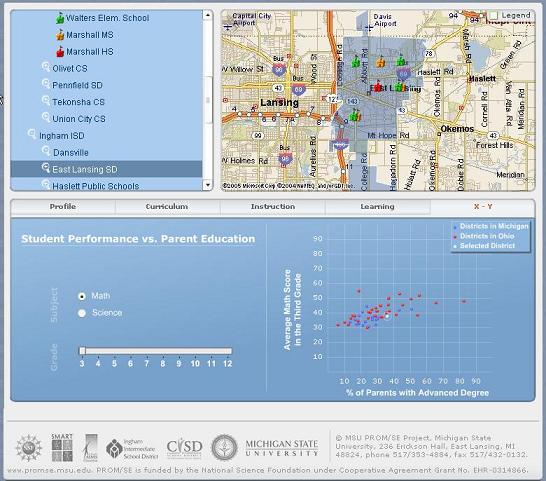 Screenshot of the website that IDV Solutions built for Michigan State U. Screenshot of the website that IDV Solutions built for Michigan State U.
What is the biggest concern that you clients hire you to address? "The recurring themes are health, safety, and security. Large organizations use GIS and location technologies to protect their assets."
What is your principal technology? "It is the location feature server (LFS). It retrieves enterprise data and overlays it on a map. Each feature that's overlaid communicates back with the database in an independent fashion. As the underlying data changes, the map changes. For example, in an application that we built to monitor a global shipping fleet on an interactive map, as the ship's speed, position, orientation, and type of cargo change, the visualization of the ship on the map changes accordingly in near real-time."
What are the various components of one of your typical applications? "The data is stored in a SQL server database; it is served up in Sharepoint and overlaid on a MapPoint Web Service map. The features are overlaid, not rasterized."
Whose aerial and satellite images do you use? "We use imagery from GlobeXplorer but are also currently working with Microsoft Virtual Earth."
Does your system also display hybrid images that combine maps and satellite imagery? "We built a hybrid for the NGA."
Who are typically your interlocutors inside an organization? "We speak to business people first, to identify the business problems they are trying to solve."
There are two main views about the effect of Google Earth's popularity on companies such as yours: one camp holds that it is increasing demand for your products and increasing customers' expectations as to features and capabilities; the other camp holds that it is eroding your market because a certain percentage of your potential customers find that the free or near free tools do most of what they need. Where do you stand on this? "We hear both and are not threatened by either. The appearance of Google Earth and Microsoft Virtual Earth has increased the visibility of geospatial technologies and helped us build our business case. People want to see their data in the context of geography. However, when corporations want to show corporate data on a map they immediately see the limitations of Google. We have created a symbiotic relationship with Microsoft. They see us as expanding Virtual Earth. They see us as a flexible and robust way for corporations to view their data in the context of geography."
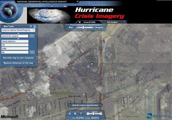 Screenshot of the website that IDV Solutions built for the NGA
What was the main purpose of the site you built for the NGA? "During Hurricane Katrina, first responders had a hard time using maps and aerial imagery because most of the features on the ground had become unrecognizable. They needed a way to marry maps and aerial images, so that they could find, for example, oil and gas pipelines and electrical power lines. One of the cooler pieces of functionality we included is a slider that allows users to change the balance between maps and satellite images. Since we built that site, the federal government has become more open as to how useful GIS is in the hands of first responders. This has led to multiple other projects. We used the site we built for Katrina as a template for sites for hurricanes Wilma and Rita. Now we are working with the federal government on security for some large national and international events."
News Briefs
Please note: I have culled the following news
items from press releases and have not independently verified
them.
CONTRACTS & COLLABORATIONS
East View Cartographic (EVC) has signed an agreement with EuroGeographics to sell EuroGlobalMap, which offers seamless, small-scale topographic coverage over 35 European countries. EVC joins a small group of value-added resellers in providing this 1:1,000,000 dataset. It includes six themes and a total of 12 layers of GIS information over countries ranging from Cyprus to Northern Ireland. This product offers official, definitive data provided by the national mapping and cadastral agencies and is suited for a wide range of uses, including development planning, monitoring, and environmental management. EVC also offers EuroRegionalMap, which includes seven thematic layers over seven European countries at 1:250,000 scale and the Seamless Administrative Boundaries of Europe (SABE) dataset containing all administrative units for 35 countries down to the district level. EVC can offer several value-added options for these vector datasets including improved language support and integration with other GIS datasets. The pan-European coverage offered by EuroGeographics can also be integrated with NGA's VMAP data to provide global coverage with enhanced information over Europe.
Telvent GIT S.A., an IT company, has signed a contract with the Swedish electricity company Vattenfall Eldistribution AB for the supply and management of an automatic metering reading system for residential customers. The project consists of the development and installation of 300,000 residential meters in the homes of Vattenfall customers living in the central, northern, and western regions of Sweden. The project will commence in the first quarter of 2006 and allows for a potential increase of up to 700,000 meters. Telvent will also provide complementary metering and data management services, with an integral service for the management and operation of the system that will allow Vattenfall to comply with Swedish regulations and improve customer service quality. The contract also includes management of metering information, reporting, and maintenance and support of all devices included in the project.
All this real-time information is critical for the billing process of an electric utility. Telvent technology will allow for the automatization of the reading process in electric meters, as well as for real-time, unscheduled readings in response to customer inquiries. It will also allow for the elimination of most meter reading costs derived from having to perform manual readings of electric consumption. The Telvent Metering System is based on Echelon Corporation's Network Energy Services (NES) technology, which enables a comprehensive range of utility applications. Vattenfall is Europe's fifth largest generator of electricity and the largest generator of heat.
OneGIS has received a purchase order from Forsyth County, Georgia for the sale, implementation, and maintenance of OnPoint, a web-GIS from Orion Technology that allows Internet browser access to both spatial and non-spatial datasets. Forsyth County is a suburban county located north of Atlanta, with an estimated current population of approximately 132,000. The new OnPoint system will be an addition to the county's current GIS, which is based on the ArcGIS platform from ESRI.
OneGIS will install and configure the new web-GIS to work with the county's existing datasets. The resulting implementation will be county-wide and will allow access to many of the county's records now residing in their Oracle-based ArcSDE Geodatabase. These will include planning, parcel, and utility data. OneGIS is a reseller and implementer of OnPoint as well as other application programs from third-party development firms that extend the capabilities of the ESRI ArcGIS platform. OnPoint specifically extends the capabilities of the ESRI Internet Map Server product, ArcIMSTM, by making it easy to configure, implement and maintain access to datasets both in the Geodatabase and in other unrelated tables.
The Ministry of Electricity and Water (MEW) in the Kingdom of Bahrain will deploy multiple licenses of InfoWater Suite, an ArcGIS-centric infrastructure modeling, management, and optimization software by MWH Soft, a provider of environmental and water resources applications software. The deployment is part of a two-year enterprise GIS project awarded to Khatib & Alami (K&A;), MWH Soft's representative in the Middle East and a utility solutions provider. K&A; will deploy ESRI and MWH Soft's geospatial technologies to deliver a single geodatabase that will embed all MEW's water and power network assets information. This will enable capture, documentation, and sharing of information for better decision making, improved operations, and enhanced customer service.
As part of its ongoing efforts to better manage and maintain regional geospatial data, the Houston-Galveston Area Council (HGAC), a regional council of governments in the Texas Gulf Coast region, has implemented GO! Sync (Edit), Tadpole Technology's bi-directional data synchronization software, as its regional data transport and synchronization service. The council encompasses 13 counties and extends across approximately 12,500 square miles, including a region with a population in excess of 5,000,000. GO! Sync uses incremental updates to synchronize data between multiple ESRI ArcSDE instances, in this case over the Internet.
GeoDecisions, an information technology company, has contracted with the St. Johns River Water Management District (SJRWMD), based in Palatka, Florida, to provide on-site GIS support. As part of the project, GeoDecisions will offer technical support for environmental monitoring, restoration, and management. Responsibilities include GIS data maintenance and mapping, geospatial and geostatistical analysis, GIS programming, and GIS/GPS training. SJRWMD is one of five regional districts responsible for the protection and management of Florida's water resources, specializing in water quality, water supply, flood protection, and ecosystem management. It is a regulatory agency that manages ground and surface water supplies in all or part of 18 counties in northeast and east-central Florida.
PRODUCTS
ADC WorldMap — a provider of comprehensive, current, and seamless geographic data for the entire world — has released ADC WorldMap Digital Atlas 5.0. The updated product now comprises complete and current national and sub-national boundaries for the entire world. Data for the administrative boundaries layer is provided by GfK MACON and thus stems from the world's largest archive of administrative and postal maps. ADC Worldmap Digital Atlas 5.0 contains many detailed layers, including capital cities, cities, roads, airports, and train lines for the entire world. For the first time, this new version of the map also contains national borders and more than 3,220 sub-national boundaries, such as provinces and regions, for 241 countries around the globe. This results in seamless coverage of the entire world using standardized map formats with the most up-to-date information. Digital maps are available as vector files in the .shp and .TAB standard format for ESRI and Mapinfo respectively, and are based on original maps with resolutions of up to 1:1,000,000. All map layers can be activated or deactivated as needed depending on importance and zoom level. The ADC WorldMap Digital Atlas 5.0 provides a basis for a variety of international applications such weather maps, ocean vessel tracking, bird migration observation, risk management for insurance companies, economic research, or for use at universities.
GE Energy has released its Smallworld Analysis and Optimization 4 (A&O;) product for the electric utility design market. The product allows users to take advantage of advanced analysis algorithms without having to become experts in the field. An addition to GE Energy's Smallworld Engineering Management product line, A&O; employs power flow analysis algorithms that are embedded as "engines" in Smallworld Core Spatial Technology, providing analysis and optimization tools to any organization managing electric networks using the Smallworld application.
With A&O;, users can perform secondary network analysis and optimization for sizing conductors and transformers based on short-circuit, flicker, and voltage drop, as well as check for overloads and voltage drop problems. Any number of customer and special loads can be placed at demand points before the services are actually available, giving the designer the capability to accurately model the load on the future network.
Aerial Cartographics of America, Inc. (ACA) has released a new means for dispatchers to quickly locate the originator of a 9-1-1 emergency call. Partnered with microDATA's xTrakker or xTrakker 9-1-1, ACA's MultiVision now has the flexibility to interface with other GIS data and CAD/CAM software. Now 9-1-1 dispatchers can click anywhere in xTrakker or xTrakker 9-1-1 and open MultiVision with automatic association to obliques for a specific location on the ground. MultiVision's high-resolution oblique aerial imagery gives dispatchers quick access to visual information of all properties within their jurisdiction. With MultiVision software they can easily display and measure vertical and horizontal objects, sites, building facades, even detailed areas such as windows and doorways, all from various angles or directions.
Intelligent Spatial Technologies, Inc. (iST) a company that specializes in location-based services for mobile users, has released the iPointer Tour Guide software module for its iPointer system. iST's iPointer system helps users explore a defined area by delivering multimedia information based on the user's geographic location and orientation. With iST's Tour Guide module, iPointer system operators create and upload customized tours around specific themes or areas of interest utilizing the software's tools. Users may then select a tour that most closely matches their interests and iPointer's hand-held unit guides them along the predefined tour via graphics and maps. The system administrator can develop and upload tours ranging from generic to highly specialized educational tours using a suite of PC-based tools. The administrators can then upload tours so that they are programmed into the hand-held unit.
The iPointer system uses GPS and digital compass technology to identify the user's location and the device's pointing angle and communicates over a wireless network with iST's geospatial database. When users wish to identify a landmark, they point iPointer's hand-held device at it and press a button. The relevant information is then displayed in text, visuals, and audio on the user's device. The iPointer can also deliver messages customized to end-user interests, such as schedules, or discounts and coupons, and uplinks end-user usage information for statistical analysis and trending. This enables management to determine valuable user information such as foot traffic patterns, changes in user interests, facility use and more.
CONFERENCES
The Mid-Atlantic Chapter of the Urban & Regional Information Systems Association will hold its 13th regional GIS conference, titled "GIS: Something for Everyone," 2006 March 15-16 at Rutgers University in Piscataway, New Jersey. Abstracts for paper presentations / posters / interactive expo are due by 2006 February 1. More details available at www.macurisa.org.
The deadline for submission of abstracts for ACCURACY 2006 (Seventh International Symposium on Spatial Accuracy Assessment in Natural Resources and Environmental Sciences) has been extended to 2006 January 20.
InfraGard, a Federal Bureau of Investigation program dedicated to promoting information sharing and dialog concerning critical infrastructure issues, will hold a GIS and Remote Sensing workshop on 2006 March 29 at New York City's Queens Museum of Art. The focus of the workshop will be the use of GIS and remote sensing in critical infrastructure protection, emergency preparedness and response.
OTHER
This year, for the first time since the introduction of in-vehicle navigation in North America, annual sales of embedded navigation systems exceeded one million units, according to NAVTEQ, a provider of digital maps for vehicle navigation and location-based solutions. Based on customer sales data from January through October, approximately one million vehicles were sold with factory-installed navigation systems, representing growth of more than 40 percent over recorded sales from the same time period in 2004. Over 90 percent of car models offering navigation systems in North America use NAVTEQ maps. The in-vehicle navigation industry in North America has grown significantly since its inception in 1996, with the most notable increases occurring over the past five years.
The Urban and Regional Information Systems Association (URISA) has recently posted the application materials for its Exemplary Systems in Government Awards, which recognize exceptional achievements in the application of information technology that have improved the delivery and quality of government services. Applications may be submitted in two categories, Single Process and Enterprise Systems. Systems in the first category are outstanding and working examples of applying information system technology to automate a specific single process or operation involving one department or sub-unit of an agency. The system application results in extended and/or improved government services that are more efficient and/or save money. Systems in the second category are outstanding and working examples of using information systems technology in a multi-department environment as part of an integrated process. These systems exemplify effective use of technology yielding widespread improvements in the process(es) and/or service(s) involved and/or cost savings to the organization. Applications must be submitted by 2006 May 22. Winners in each category will be recognized at URISA's 44th Annual Conference, 2006 September 26-29, in Vancouver, British Columbia.
The Enterprise for Innovative Geospatial Solutions (EIGS) is a statewide industry cluster of 36 private companies, six university research programs, four state agencies, and seven complementary partner programs working together to research, develop, and market new geospatial products from Mississippi. From seven charter members to the current 36 members, the cluster has shown consistent growth from year to year, contributing to the Mississippi economy through higher-paying, high-technology jobs. With a total payroll for the cluster of nearly $30 million and an average annual salary of $52,500, this industry continues to be a solid investment for the state. In 2005, EIGS member companies invested more than $39 million in Mississippi business operations, a growth of more than $10 million from the previous year.

GIS
Monitor Back Issues
Advertise with Us
You
can reach more than 17,000 GIS professionals every issue by
sponsoring GIS Monitor. For more information, email us.
Contact
Please
send comments and suggestions to:
Matteo Luccio, Editor
GIS Monitor
Ultimate
Map/GIS Directory — Your search is over!
GIS Monitor is published by:
GITC America, Inc.
100 Tuscanny Drive, Suite B1
Frederick, MD 21702 USA
Tel: +1 (301) 682-6101
Fax: + 1 (301) 682-6105
Subscribe/Unsubscribe
If you wish to subscribe or unsubscribe visit our subscription
page.
|