

2006 December 14
This issue sponsored by
Professional Surveyor Magazine
If, for some reason, you cannot read this document, please visit:
http://www.gismonitor.com/news/newsletter/archive/archives.php?issue=20061214
Editor's Introduction
This week I report on an Autodesk seminar on CAD and GIS that I attended at Portland Precision Instruments (PPI) and the conversation I had afterward with the two presenters and a PPI application developer. (This will be the last time that I focus on the relationship between CAD and GIS this year. I promise!) This discussion of Autodesk's geospatial products is peppered with references to the industry's "800 pound gorilla." I also bring you a letter from a reader and a tidbit from popular culture. Plus, my usual roundup of news from press releases.
For an article in next week's issue, I would like to hear from anyone involved in, or with informed opinions on, the proposal to establish a federal advisory committee for the NSDI. Just send me a message with "NSDI governance" in the subject line and I will send you my questions.
— Matteo

Autodesk: Beyond Vanilla AutoCAD
Autodesk's Infrastructure Solutions Division (ISD), the company's GIS branch, is promoting Map 3D as the best way to "bridge the CAD-GIS gap." Map, it claims, allows organizations to transition seamlessly from the world of CAD to that of GIS — maintaining the precision of the former, accessing data created in the latter, and using tools from both, without retraining or replacing staff.
According to Peter Southwood, an ISD Geospatial Technical Specialist, Map is successfully "revisiting" such traditional functions as drawing clean-up tools, standards, classifications, and multi-user access to the same AutoCAD drawings. The product builds on Autodesk's feature data object (FDO) technology, which allows users to read and write data in SDF, SHP, ArcSDE, MySQL, ODBC, OGR, GDAL, WMS, and WFS formats.
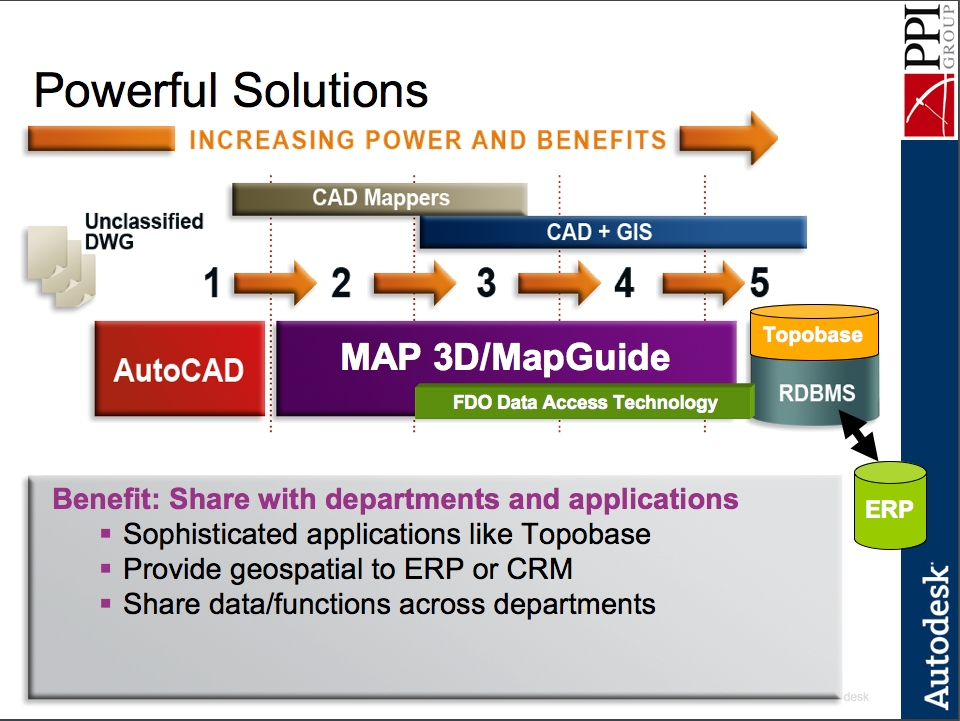
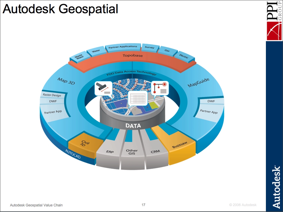
Courtesy of Autodesk and PPI.
Southwood, who has been with ISD for ten years, has 25 years of experience in the CAD/GIS industry, including a stint as lead application engineer for Autodesk Asia Pacific. He was in Portland, Oregon, this week, for his first "road show," as he called it, with Portland Precision Instruments (PPI), which recently set up a new geospatial group. Southwood presented a three-hour seminar jointly with Mike Dana, a PPI Geospatial Solutions Analyst. Dana, who holds an M.S. degree in geography and has been in the geospatial industry for 12 years, describes himself as an "ESRI user until 2006." He handles account management, "trying to listen to people's business model and to see whether we've got some ideas that might help them out geospatially, product-wise," he says.
According to Dana, the roughly twenty seminar attendees were from both the private sector and the public sector, including seven from local governments in the Portland metro area, some from the telecom industry, and several IT people. Several were ESRI customers. (I noticed that, with only one exception, everyone in the room was a man.)
The three-hour presentation covered two Autodesk products, Map 3D and Topobase, and the company's "geospatial value chain" — which starts with AutoCAD and ends with Topobase:
- AutoCAD — DWG
- Map 3D — DWG
- Map 3D — MapGuide — FDO
- Map 3D — Spatial Databases
- Topobase — Database Solutions
ISD, Southwood told me, is "looking at how organizations can maximize the investment of both people and data" by transitioning from "a vanilla AutoCAD" to "an Autodesk Map environment." Many AutoCAD users, he claims, "are unaware that you can have a product like Map gaining multiple user access to the same older CAD drawings." He acknowledges that ESRI is still the leader in the area of "deep analysis" but told me that, in response to pressure from its users, Autodesk is moving "by quantum leaps" to close that gap.
In his presentation, Southwood stressed Map's ability to access and edit ESRI data and demonstrated it on screen, linking to a live database. He then demonstrated how Map deals with imagery: in a just a few seconds, he appeared to import a 1.5 GB raster satellite image of the San Antonio, Texas, metropolitan area; he then zoomed in on The Alamo. The trick, he pointed out, was that Map had not actually imported the huge raster file, but only created a 50 KB link to it; when he zoomed in, Map selected the most high-resolution image available for the new extent. He also demonstrated Map's ability to overlay features onto Google Earth.
Southwood commented that MapGuide — Autodesk's free, open source Web publishing solution — "blows away" ESRI's ArcIMS; that Microsoft has embedded Autodesk's DWF, which he describes as an "intelligent PDF," in its new operating system, Windows Vista; and that TopoBase works strictly with Oracle, for which Autodesk is an authorized reseller. However, he pointed out, Oracle Database 10g is available as a free download.
Autodesk's worldwide roll-out of Map has been "incredibly good," Southwood says. Among the reasons for this success is, he cites, the ability it gives users to "get to the ESRI data directly, without the need to translate," often "maintaining the integrity of the original data." Autodesk's decision to open-source the product, he says, was wildly successful — "It has exploded, it's just gone nuts." — and the same is the case for TopoBase, which Autodesk launched three months ago. He describes TopoBase as "a solution" that Autodesk's partners help provide to its customers, rather than a product. "A customer can take it on board and run with it, but data models and business rules require a little bit more thought process."
While Autodesk is mostly known for AutoCAD, it has "many, many facets" Southwood says, and ISD is the company's fastest-growing division. While he readily acknowledges that ESRI is still the industry's proverbial 800 pound gorilla, "the tide is turning," he says. Meanwhile, if an ESRI solution can resolve a client's business issue, "that's great."
Autodesk, Southwood points out, has partnered on TopoBase with CH2M Hill, which, in turn, has "a very healthy partnership" with ESRI. "Very, very early at the inception of the GIS division of Autodesk, we had an extremely strong relationship with ESRI, because the CAD tools from AutoCAD were the tools used within ESRI products." However, he says, that relationship changed as soon as Autodesk released Map. His company, he says, has also had "an extremely strong partnership with Oracle, over many years" and "differing relationships with Intergraph," which "brought some strengths to us in the early days."
Courtesy of Autodesk and PPI.
PPI's Geospatial Group
A few months ago, PPI set up its geospatial consulting group. In addition to Dana, it hired Dusty Gallinger, as an Application Engineer. Gallinger — who has a BS in computer engineering, seven years of experience as an Autodesk technical specialist, and experience doing third party application development on Autodesk products — says that he is "attempting to be all things technically geospatial" at the company. I asked him how he uses GIS. "I don't use it in a production sense," he told me. "We are here to help our customers. This geospatial team at PPI is very new. We are just getting our hands wrapped around the opportunities, introducing ourselves to our customers."
Does Gallinger see a pattern in customer needs? "On the technical side," he told me, "the issue that I've dealt with, in the limited numbers of customers that I've dealt with to this point, has been the interoperability between Autodesk and ESRI. That seems to be the theme, no matter where we go. They are using ESRI. They want to explore other options, Autodesk being the other most popular one that we've seen, probably because we are now an Autodesk vendor."
"It's super exciting to me," Dana says of his new job. "It felt like a risky change for me to make, having invested so much time and energy on the ESRI side. It became a no-brainer the more I talked to PPI, the more I learned about what was going on with Autodesk geospatial." Dana brings "the industry context," he says, while Gallinger fully understands the development environment and the Civil 3D and Map product lines.
Interoperability, says Dana, is one his customers' biggest concern and most future developments in geospatial technology will probably take place in databases. Most GIS shops, he says, will be hybrids, with multiple vendors. "That's OK. We're here to listen, find out what is and isn't working, and then propose ideas" — whether that means developing applications for customers or providing them with technical training. "We are starting to carve a niche for ourselves helping people deal with issues around SDE and interoperability" — such as activities that are unexpectedly processor-intensive.
From CAD to GIS
Rather than wanting to move from CAD to GIS, Gallinger says, most of his customers "want to exist in both worlds." Map "allows them to have the precision of CAD drafting but is a GIS tool as well." Southwood, whose background is in architecture and design, claims that, because he uses Map, he knows only about ten AutoCAD commands, which he uses to access more traditional CAD functionalities. "Progressively, year by year, that line between CAD and GIS has been getting fuzzier and fuzzier and fuzzier. It is in the process of just melting, blending." Geospatial professionals, he argues, are increasingly focused on information, whichever its source.
Courtesy of Autodesk and PPI.
Does this mean that the various geospatial professions will begin to merge as well? No, says, Southworth; the professions, while overlapping, will never go away. "You are going to have PEs, architects, and professional GIS personnel." The data, however, is being increasingly shared, rather than kept in silos. Will the changing tools change the division of labor? "I'm certain that [nowadays, in college], as a professional engineer, part of my curriculum would be GIS-based," says Southworth. "I grew up [when surveyors still used] chains."
Dana points out that CAD and GIS tool sets are starting to look more and more alike. This is no accident, says Southwood. One of the greatest compliments he ever received, he recalls, was during a presentation he did for an extremely large ESRI user in Los Angeles: "I was presenting some of their data within Autodesk Map. This gentleman stopped me and said 'Hey, that looks just like ArcView, but a lot easier.' He was actually the ESRI administrator within this organization."
"GIS has traditionally been about birds and bunnies and trees and that sort of thing," says Southwood. "That is the way it has always been viewed and it is not quite accurate, because it is actually dealing with the analysis of some very, very complex data and models. The strength that CAD brings is that precision, that engineering. Those two strengths are merging." Autodesk Map, he argues, accomplishes that merger best.
Could a new AEC company — with complete freedom to choose its staff, training, and tools — do all of its geospatial work using just Map? "At the moment, I would say, honestly, a good 80 percent you could do in Map," says Southwood. "It is common knowledge that we are lacking in those deep analysis tools that ESRI are very, very clever in doing. As a company, Autodesk is pretty aware of that and we are getting there." According to Dana, "the missing pieces on the analysis side" will come mostly "from the database side," especially Oracle Spatial.
Letter to the Editor
Dr. Thomas H. Mace, of the NASA Dryden Flight Research Center in Edwards, California, sent me this message, specifying that it represents his own opinion, not necessarily NASA's:
I read with some interest Cruver's piece in GIS Monitor on spatial thinking. It reminded me of a lecture that Professor Arthur Robinson used to give about "literacy, numeracy, and graphicacy" in his course on small scale cartography at the University of Wisconsin-Madison. His main point was that we educate people in the Western world reasonably well to read, write, and perform simple arithmetic, but we fail miserably in educating the general public to understand and use graphical representations of reality (maps). Of course, the GIS-era words are different, but the point seems to remain. It's unfortunate that after over thirty years and the proliferation of spatial data over the Internet, the problem he articulated still remains. I'm not sure Google Earth will fix that. I think we still need some old fashioned teachers, like Robbie.
Briefly Noted
Geospatial technology is penetrating popular culture in ever new ways. GPS receivers are now even being used as metaphors for any kind of guide. In his blurb for The New York Times Practical Guide To Practically Everything, edited by Amy D. Bernstein and Peter W. Bernstein, which appears in a full-page ad for the book in The New York Times, Tom Brokaw, author of The Greatest Generation and former anchor of NBC News, wrote: "This handy guide is a wide-ranging and lively GPS system for the many bewildering choices and questions we all have every day."
News Briefs
Please note: I have culled the following news items from press releases and have not independently verified them.
-
CONTRACTS & COLLABORATIONS
-
The U.S. Department of Homeland Security (DHS) has signed an Enterprise License Agreement (ELA) with ESRI that will enable the agency to deploy the full spectrum of ESRI GIS software throughout its organization. The comprehensive agreement provides the department with an easy and cost-effective method to provide enterprise-wide GIS software, professional services, and training to DHS employees. It will enable DHS to expand the use of GIS to mitigate against, prepare for, and respond to events as well as secure U.S. borders, enable trade and transportation, and enforce U.S. law.
The ELA provides the flexibility to deploy unlimited quantities of most ESRI software offerings. It makes available significant cost savings for other ESRI software, services, and training. In addition, DHS users will have access to the very latest software and upgrades as soon as they are available.
The core technology for the ELA is ESRI's ArcGIS software, which is an open and interoperable technology platform that provides advanced visualization and cartographic capabilities, spatial analysis, geographic data management, and more. ArcGIS complies with the Federal Enterprise Architecture and DHS's enterprise architecture. ArcGIS software is a complete system to author, serve, and use geographic information. The technology gets geographic information to those who need it including analysts, decision makers, field-workers, and the public through its support of mobile, Web, and desktop clients.
-
MapInfo Corporation, a provider of location intelligence solutions, has partnered with The Gadberry Group, a consulting and data solution provider. As a value added reseller, The Gadberry Group will further expand MapInfo's penetration in key industries such as telecommunications, marketing, and retail, where Gadberry has an established presence.
A trusted advisor of technology services, Gadberry offers Location Based Services, an extension of its solution consulting group that delivers services such as the creation of custom analytic solutions. Combined with MapInfo location intelligence solutions, Gadberry's MicroBuildT information data products, consulting and software development experience will offer significant value to the companies' mutual customers. The partnership will open new market opportunities and growth for Gadberry as a value added reseller of MapInfo location intelligence solutions.
Hundreds of customized and packaged location intelligence solutions are available through MapInfo's partner program. MapInfo partners offer a broad portfolio of software and data sets from which companies can realize the value of location information to improve business processes, enhance customer service and uncover new market opportunities. As a value added reseller, The Gadberry Group will benefit from the technical, marketing and sales support that MapInfo delivers.
-
-
PRODUCTS
-
MWH Soft, a provider of environmental and water resources applications software, has launched the newest version of its Designer extension, an automated design solution for water distribution systems that runs on both H2ONET CAD and InfoWater GIS platforms. By leveraging the advanced, customer-driven functionality of this major software release, water utilities worldwide can significantly raise productivity and efficiency by rapidly developing optimal capital improvement strategies that minimize costs while enhancing system reliability and performance. All aspects of the water distribution system can be considered within the optimization, including pipes, pumps, and storage tanks.
MWH Soft Designer's pipe network optimization capability combines the latest advances in computational Genetic Algorithm optimization technology with elitist and global control strategies. These features allow Designer to quickly identify the best combination of pipe system improvements — rehabilitation (cleaning and lining), replacement, strengthening, and expansion options — and new pumping and storage facility construction to meet desired hydraulic and water quality performance criteria at minimal cost. Other key Designer features enable water industry professionals to develop more accurate and compelling design and rehabilitation solutions by considering any modeling condition time frame (e.g. maximum day), multiple design scenarios (e.g. maximum day plus fire), and complete extended-period simulation designs (e.g. 24-hour operational design).
-
Leica Geosystems, which first introduced large-format digital aerial cameras with its ADS40 in 2001, has now developed two new sensor heads, the SH51 and SH52, for the ADS40 system. Equipped with patented Leica beamsplitter technology, the SH51 sensor head provides perfectly co-registered color, infrared, and panchromatic images. The SH52 adds a second beamsplitter for perfectly co-registered stereo viewing of all image bands. These two new features allow users to employ the five-band co-registered imagery for all aerial surveying and airborne remote sensing applications. The ADS40 saves time and money by offering simultaneous, wide-area acquisition of true high-resolution panchromatic, color, and color-infrared digital images.
The single-lens design of the Leica ADS40 eliminates the need for multiple-lens image patching and pan-colorizing (pan-sharpening) with low-resolution spectral band images that cause color distortion. This new product achieves optimal color fringe-free stereo viewing with a constant stereo viewing angle which provides an uncompromised geometric and radiometric representation of the earth's surface. The second generation Leica ADS40 is designed for versatility, premium performance, economical operation, and exportability options.
-
Leica Geosystems has announced the debut of the company's MPiA (Multiple Pulses in Air) technology, a new laser system that measures distances at significantly higher rates than conventional time-of-flight measurement tools. The technology has been successfully tested in real-world applications and is now ready for incorporation into product lines. Unlike current time-of-flight systems, Leica Geosystems' new MPiA technology does not depend on receiving the target reflection before starting the next distance measurement cycle. Users will now be able to obtain the same distance measurements in less than half the time without sacrificing data accuracy.
-
Sanborn, a geospatial solutions company, has released a new solution to simplify access to and distribution of geographic data with the Sanborn GEOBOOK Author software product, which provides a flexible, cost-effective solution that makes it easy to publish and distribute geospatial data. Based on Sanborn's GEOBOOK application, the Author software provides the capability to quickly build GEOBOOKs by embedding interactive maps, text documents, images, and other data visualization controls. By removing format and platform compatibility challenges in ways that are transparent to the user, the GEOBOOK Author combines GIS data with imagery and documentation to provide dynamic output for multiple disciplines to use and understand.
-
-
CONFERENCES & TRAINING
-
The National Emergency Number Association (NENA) and the Urban and Regional Information Systems Association (URISA) have announced the Second Geospatial Integration for Public Safety Conference (formerly URISA's Addressing Conference: Street Smart and Address Savvy) to be held 2007 April 15-18, in New Orleans. This conference is designed to bring together GIS professionals, addressing coordinators, and 9-1-1 and emergency response specialists for a networking and learning opportunity. The inaugural GIPSC Conference took place in 2006 April in Nashville.
The Conference begins with a choice of three optional full-day workshops on April 15:
- Introduction to Next Generation 9-1-1
- Understanding GIS for the PSAP
- Addresses and IS/GIS Implementation: Key to GIS Success
Monday and Tuesday, attendees may choose from three program tracks:
- Addressing Basics, Coordination, and Standards — Is your agency embarking on a new project? Does your organization have the necessary documentation to support existing addressing policies? Would you like to have the ability to enforce what has already been changed or assigned? This track will focus on both the automated and manual aspects and phases associated with administering addresses, including the new FGDC Street Address Data Standard, and preparation for the 2010 Census and LUCA (Local Update of Census Addresses) program. Sessions within this track will provide insight on topics including identifying standards, developing documentation and policy, establishing workflow, collecting inventory and issuing citations.
- Emergency Response and 9-1-1 — Prompt emergency response requires accurate location information. Accurate location of spatial data is one of the most important products of a geographic information system. Marrying automated dispatch data and GIS location technology is a prime example of using technology to work smarter, not harder. Sessions in this track will focus on projects at the local, state, and Federal levels of effective emergency response using GIS. Presentations in this track demonstrate what is possible when two powerful technologies collaborate for informed emergency response.
- Case Studies of GIS Integration with Public Safety — Are you having nightmares about integrating GIS with public safety? Do you go to bed at night wondering how to integrate GPS, Addressing, Wireless, Mapping, and Imagery into your PSAP or public safety offices? Do you worry about how you are going to get the data you need to set up an Enterprise GIS and how you are going to fund it? This track will focus on presentations from real-life experiences in integration of GIS and public safety technologies; what works and what doesn't.
- Other/Hot Topics — Find out more about imagery, NG 9-1-1 and much more in these sessions dedicated to the hottest topics in the industry.
Post-Conference Tours: On Wednesday morning, attendees may register for one of two optional tours:
- New Orleans PSAP
- Hurricane Katrina Tour
Continuing Education Credit: GISCICertification points earned for attending one workshop and the GIPSC Conference = 0.5 GISCI education points. Attendance is recognized for continuing education credit toward recertification as an Emergency Number Professional (ENP) with National Emergency Number Association, as well as for recertification credit with the National Academies of Emergency Dispatch for police, fire, and medical emergency dispatchers.
-
MAPPS, the association of private mapping, photogrammetry, and geospatial firms, will host its Winter Meeting 2007 January 21-25, at the Naples Grande Resort in Naples, Florida. The sessions to be presented at the meeting include:
- Oblique Aerial Imagery: An Emerging Market?
- Geospatial in Florida: Everglades, Hurricanes & More
- Is Geospatial an Industry or a Profession?
- Legislative Update & Licensing Report
- MAPPS Salary Survey Results
- Belts, Suspenders, Girdles & Garters, Oh My!
- Geospatial One Stop for Atheists, Agnostics & True Believers
- Going Global: A Look at the Global Geospatial Market
-
ESRI's 2007 Federal User Conference (FedUC) will be held 2007 January 9-11 at the Washington Convention Center in Washington, D.C. Conference attendees will gain insights into the latest GIS software and solutions for unique federal problems. Discussion and demonstrations will address how GIS is used to improve coordination and information sharing, reduce costs, increase productivity, and enhance decision making.
Attendees at FedUC will include federal government professionals from disciplines such as defense, demographics, law enforcement, and health. State and local government professionals are also encouraged to attend. GIS users at all levels of government can take advantage of this opportunity to learn how GIS is utilized throughout the nation and build strong networks for improved problem solving.
A Plenary Session will open the conference on Tuesday. ESRI president Jack Dangermond will describe the conference theme—GIS: The Geographic Advantage for the Nation—and show examples of organizations using GIS to make a difference for the country. Dangermond will also share his vision for GIS, software strategies, enterprise architecture, interoperability, and collaboration strategies for serving geographic knowledge. The Plenary Session will include innovative software demonstrations and a Keynote Address.
During the conference, ESRI software users will present paper sessions that offer attendees an opportunity to see how other organizations are developing GIS, overcoming challenges, and planning for the future.
Paper sessions will include the following tracks: asset/facility management, demographics, law enforcement, system architecture, technology, health, military, land and environment, and homeland security and emergency response. There will also be panel discussions about Defense Installation Spatial Data Infrastructure (DISDI). In technical workshops, ESRI staff will explain current technology and offer tips and tricks on using the software.
-
-
PEOPLE
-
DigitalGlobe, a provider of high resolution commercial satellite imagery and geospatial information products, has announced that Steve Milton has joined the company as Vice President of Software and Systems. In his new role, Milton will direct DigitalGlobe's software and systems business office, leading the worldwide development of the company's software systems supporting the operations and distribution of geospatial content. Milton will report directly to Jill Smith, Chief Executive Officer of DigitalGlobe.
Milton was most recently the Chief Technology Officer at Enservio, Inc., a contents property valuation solutions company for the insurance industry, where he built the technical teams and drove the product and technical service roadmap of the company. Prior to that he designed and delivered commercial products in industries such as artificial intelligence at Andersen Consulting, voice recognition at Nuance and product configuration at Trilogy.
Additionally Milton has been instrumental in the launch of two key e-commerce systems — Living.com and PCOrder.com at Trilogy. His systems have been successfully deployed with customers such as HP, AT&T, Ford and Sprint. Milton earned his Bachelor of Science in aerospace engineering from the University of Texas.
-
-
OTHER
-
The Enterprise for Innovative Geospatial Solutions (EIGS) has announced highlights recapping the year's accomplishments and achievements for Mississippi's Geospatial Industry Cluster. EIGS is a statewide cluster of more than 30 private companies, six university research programs, four state agencies, and eight complementary partner programs working together to research, develop, and market new geospatial products from Mississippi. Since 1998, the State of Mississippi has actively invested in the growth of an industry cluster within this emerging high tech sector.
Much of 2006 was defined by recovering and rebuilding efforts in response to the devastation of Hurricane Katrina. Despite the fact that a majority of EIGS members are located in the Gulf Coast region and were personally and professionally impacted by Katrina, the cluster saw close to a ten percent growth in geospatial jobs. Additionally, the average annual salary increased by five percent to $55,000.
One of the key achievements for the cluster was the publication of Mississippi's Guide to Geospatial Technology. This publication was a unique collaboration between EIGS and the Mississippi Business Journal and has been distributed to over 30,000 readers. It focused on how geospatial technology can provide useful, cost-effective solutions for several industries, government organizations, and business areas. The Guide has served to increase the awareness about geospatial technology and to reach decision makers who can most benefit from the capabilities of Mississippi's industry cluster.
Other notable accomplishments and awards received by members and partners of Mississippi's Geospatial Technology Cluster include:
- Craig Harvey of NVision Solutions was selected as the 2006 SBA Small Business Person of the Year for Mississippi.
- The Geospatial Technology Apprenticeship Program (GTAP) was presented with a 2006 Innovator Award from the Southern Growth Policies Board.
- Digital Quest and SkillsUSA established the first-ever National Geospatial Competition.
- Forest One, Inc. was awarded a U.S. Forest Service contract to develop new LiDAR technology, pushing the frontier of the application of LiDAR to forestry.
- The MS Automated Resource Information System (MARIS) website was selected as one of the best education resources on the web by StudySphere.
- Dr. Scott Samson with MSU's GeoResources Institute was named one of ESRI's Top 5 Instructors for the 2006 Third Quarter.
Delta State University and the MS Department of Environmental Quality were honored with a 2006 Special Achievement in GIS (SAG) award at the Annual ESRI Conference for their use of GIS technology during Hurricane Katrina.
-
The Geospatial Information & Technology Association (GITA) has launched a new website and is getting into the giving spirit of the season with 12 Weeks to Annual Conference—a rewards program to celebrate the new website and gear up for GITA 2007. GITA will be awarding prizes to 12 site visitors. To enter, patrons must fill out a very short entry form. Each week until conference, GITA will draw a winner from that week's entry forms.
The grand prize winner will receive the last—and best—of the 12 prizes at Annual Conference 30 in San Antonio, Texas. Everyone who fills out an entry form from 2006 December 12 to 2007 March 4 will be eligible for the grand prize. (Winners of a weekly prize are not eligible to receive the grand prize or any other weekly prizes. Visitors can fill out a new form each week, but only once per week. The winner of the grand prize must be present at Annual Conference 30 in San Antonio to win.)
Annual Conference 30 is slated for 2007 March 4-7 in San Antonio, Texas, and will include 16 half-day seminars, 99 paper presentations, four panel discussions, user forums, networking socials, and an extensive product and service exhibition. Two separate one-day user conferences, hosted by Oracle and Ten Sails, will be held on the Thursday immediately following the GITA conference.
-
ESRI has announced the availability of GIS Day/Youth Mapping patches and pins that can help organizations promote the importance of geography to young people through GIS technology. Interested individuals and organizations, such as the Girl Scouts of America, Boy Scouts of America, 4-H Club, and others, can use the GIS Day awards as part of their educational activities.
Youth organizations are already planning to use the GIS Day awards. For instance, Lisa McCullough, a GIS senior analyst for Riverside County, California, who is also a Girl Scout leader, plans to use the GIS Day patch for her daughter's Cadet and Senior Girl Scout troop as well as her son's Cub Scout pack.
GIS Day/Youth Mapping patches and bronze pins are now available online. The availability of the GIS Day/Youth Mapping awards is part of ESRI's ongoing efforts to provide materials that assist others in the planning and implementation of geography-related events and activities including the annual worldwide GIS Day.
-
Advertise with Us
You can reach more than 23,000 GIS professionals every issue by sponsoring GIS Monitor. For more information, email us.
Contact
Please send comments and suggestions to:
Matteo Luccio, Editor
GIS Monitor
Ultimate Map/GIS Directory — Your search is over!
GIS Monitor is published by:
Reed Business Geo, Inc.
100 Tuscanny Drive, Suite B-1
Frederick, MD 21702 USA
Tel: +1 (301) 682-6101
Fax: + 1 (301) 682-6105
Subscribe/Unsubscribe
If you wish to subscribe or unsubscribe visit our subscription page.