Letters, Points of Interest, Week in Review (Announcements, Contracts, Products, Events, Hires) Back Issues, Advertise, Contact, Subscribe/Unsubscribe If, for some reason you cannot read this document, visit: http://www.gismonitor.com/news/newsletter/archive/012904.php
Federal User Conference Plenary The opening session followed the formula of the annual ESRI User Conference with Jack Dangermond setting the vision for the company and products, a few keynotes by notables, and a detailed look at products in the afternoon. Dangermond also highlighted many maps and applications sent by users to illustrate the "good work" federal GIS practitioners are doing. That good work was also featured in a booklet on each chair called GIS in the Federal Government which included a look at agencies and programs and their GIS use. It includes maps, applications, posters (shrunk down to page size), as well as descriptions of agency and program missions. As someone who finds the federal government a bit overwhelming, this is a "keeper" for my reference shelf. In his morning address, Dangermond highlighted many of the ideas from last year's user conference. The new underlying theme, I think, is that we are moving from a "tools and data" approach to GIS into an "intelligent" GIS. That intelligent GIS is built on five key parts and is further along the data -> information -> knowledge continuum than we've ever been before. Another key term heard throughout the day was "federated," which I had to look up to be sure I understood. Federated, according to Dictionary.com, means "to cause to join into a league, federal union, or similar association." Or in GIS terms, Dangermond noted, it's a system that's distributed, networked, interoperable (has a "dial tone"), collaborative, and service-based. In speaking about interoperability, Dangermond highlighted the move from conversion, to direct reading of other formats, to data storage in a standard way in a database (using OGC's Simple Features Specification), to Web Services. I think this is the first time I've seen that technology added to the end of this list, but it seems a logical step. Still, I for one would be amazed if new IT standards really provide enough power and structure to integrate all the data and tools of GIS without some tinkering. Perhaps I'm simply not able to see far enough ahead. Senator Adam Putnam, of Florida, chairs the Government Reform Committee's Subcommittee on Technology, Information Policy, Intergovernmental Relations, and the Census. He presented a keynote focusing for the most part on the challenges of knowing how money is spent on geospatial data and how to prevent duplicative acquisition of that data. He noted more than once that the Office of Management and Budget (OMB) had trouble determining spending on geospatial data. In the end, OMB guessed that spending was $2-4 billion and about half of that spending might be duplicative. Part of the reason that geospatial doesn't get its due attention on the Hill, Putnam noted, is that some members of Congress are simply not tuned in to technology. As he put it, some of his colleagues "think a Blackberry is what you put on your cereal and that a Palm is state tree of Florida." He got his own sense of the complexity of geospatial issues when trying to retrieve a map from the NOAA website for a fishing expedition. A relatively savvy user, he had a challenging time finding what he needed. While Putnam noted that progress is being made, he doesn't pretend everything is rosy. We "are not seeing coordinated leadership" he noted. He made it clear that the nation needs someone to answer the question about how much we spend on geospatial data and how to prevent duplication. That's not yet someone's job, he admitted. The next hearing on geospatial, to follow up on the one last June, is already planned for this year. Putnam wrapped up by making the memorable statement that geospatial technology "challenges our traditional way of organizing our government." I'll suggest that may be another reason for the complexity of moving it forward at the federal level. Dangermond is clearly taken by the young, and young-looking, senator. Putnam at one point referred to himself as "looking like Opie." Dangermond noted that the senator was not born until ESRI was already 10 years old, as he gave Putnum a fatherly clap on the shoulder. The second keynote was not so much a keynote as a success story introduced by an ESRI employee about CALMAST. She explained that many organizations around the San Bernardino area spent six months preparing a common shared database aimed at fire issues. Then when the fires came last fall, they already had many of the tools and data needed. One of the key tools was 3D. When, just for show, several key responders were looking at ArcGlobe, they immediately began planning their next steps for the day. The 3D aspect of GIS in fire fighting helps responders, among other things, be realistic about what machinery can travel into and operate in remote areas. Wrapping up, Dangermond noted that the big lesson here was that the players had come together before the disaster, making response far more effective. As he put it, "organization matters." The final keynote presentation of the morning was from Hank Garie, Executive Director of Geospatial One-Stop. He was joined by Barb Ryan of USGS and Ivan Deloatch new staff director of the Federal Geographic Data Committee (FGDC), in what was a preview of a session the following day. The goal of the keynote, and the later session, was to help make clear the relationships among GeoSpatial One-Stop (GOS), The National Map, and FGDC. I was pleased that Garie and the others were clearly listening to the confusion of federal, state, and local organizations on this matter. (This was driven home to me last fall when a state GIS person explained that his state was a "National Map" state, not a "GOS state.") Garie made it clear that "we" are in this together. I like to think by "we" he means all U.S. federal, state, and local GIS users, though the room held only ESRI software users. Garie then went on to explain that the three leaders of the programs had come together to clarify roles, leverage collective resources, and convey a clear message. That message in a nutshell, also reiterated in a session the following day on the Future of NSDI, is this: FGDC is charged with creating policy, standards, and training to support NSDI, while GOS takes on providing access to geospatial data ("Gateway to Discovery") and The National Map focuses on "causing the construction" of content. That simple statement is a huge step forward. I'm hopeful that a graphic explaining those relationships will soon appear that we can all carry around in our heads to keep the relationships straight.

A demo of some of the new goodies in ArcGIS .9.0 included: - rasters stored as attributes (raster can just be "put it in the geodatabase" - the example was a scanned well log associated with a well) - URLs in the database are now "hot" meaning there's no need to explicitly create hotlinks - a data interoperability extension which embeds Safe Software's 70+ supported formats (some direct, some via import/export, more on that below) - a "one stop" label manager, and enhanced labeling (via a Mapplex Extension) did an amazing job placing "unplaced" labels by using a series of user defined parameters prioritizing different label placement factors There was one other impressive labeling feat: masking linework so that the value of, say contours, can be clearly seen. Another set of tools are the type I'm used to seeing in the CAD world - the ones that "save clicks." In ArcGIS 9.0 you can: - click the space bar to turn layers on and off - use the enter key to bring up layer properties - use a key to "pause" drawing while turning on and off a whole series of layers. Once the new configuration is set, it's time to resume drawing as a single drawing event instead of the very slow process as each layer tries to draw separately. This demo drew considerable applause. Another goodie available at ArcGIS 9.0 is an enhanced ArcGIS Publisher Extension. Recall that's the tool to make data for ArcReader, the free viewer intended to ease data distribution challenges. The very first time I saw it (in September 2001) the key question was "So where does the data go?" The answer I got then, from Rich Turner, was "well you can put it on your server or on a CD" just didn't cut it. Unlike the simple PDF format, using Publisher seemed quite complex. This complexity meant that I for one set ArcReader aside as unfinished. Now, ESRI has solved the problem. ArcGIS Publisher will now automatically package up all the data (from CAD, Web services, raster, etc.) so it can travel along with the PMF (that's the format for ArcReader maps). ArcGIS Publisher also ships with an SDK so developers can build custom ArcReaders for their users.
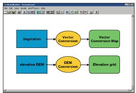
We then took a long look at the modeling tools and the five ways to create models including via a scripting language like Python and via Model Builder (at right), the graphic interface. A group exploring flooding in Texas combined its workflow into a complex model and found that maps that once took a week are now created in two minutes. ArcGlobe with its 3D rendering might be considered "eye candy." That's not so, says Clint Brown. He positions ArcGlobe as a tool for large global data exploration in an interactive environment. The product, part of the 3D Analyst Extension is delivered with a basic worldwide database. Brown noted that the first iteration of ArcGlobe will be built for visualization. In time ESRI will add cartography and other, more analytical tools. That said, some analytical tools were demonstrated, ones I recall seeing in 3D Analyst some years ago. Only now, they were visualized in ArcGlobe. These included a line of site analysis and the results of a 3D propagation model.
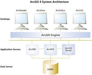
Developer tools are perhaps one of the strongest offerings in ArcGIS 9.0. ArcGIS Server provides a multi-user server solution, simplified management on a single machine and lower cost of administration and I believe, licensing. ArcGIS Server offers complete GIS functionality (that is, all of ArcGIS) and clients can be fat desktop ones or thin Web ones. ArcEngine provides a "headless" ArcGIS and comes, like MapObjects, in an SDK version for building apps and runtime version for distributing them. The big difference between MapObjects and ArcEngine? The latter has all of ArcGIS inside, while the former is a small subset. Engine and Server will run on several platforms including Solaris, RedHat Linux, and Windows. Developers can use .NET, C# or Java for their work. ArcSDE retains its role as the "gateway to multi-user relational database management systems" and keeper of long transactions. What's new? Down the road expect support for open source databases. MySQL and PostGres were both mentioned. The final discussion addressed ArcIMS, clearly defined as a tool for GIS Web publishing and Web services. Brown went on to say that it was the "primary publication technology in use today [in GIS]" with some 25,000 implementations. For many users, he noted, it's the first step toward an enterprise implementation. There are four new ArcIMS extensions in the works: Data Delivery - which integrates Safe Software's SpatialDirect and allows "clip/zip/ship" functionality in many formats Portal Extension - to build custom Geospatial One-Stop-like portals Route Server - to allow routing Tracking Server - for the display of live data feeds ("Tracking Analyst for ArcIMS") Instead of new flashy demos, we saw some real federal uses of ArcIMS from the Federal Aviation Administration, National Oceanographic and Atmospheric Administration, and United States Postal Service. For those who want to add it their calendars, Dangermond said ArcGIS 9.0 would probably follow this release schedule. After a solid third beta, the software would be "gold" (that is, ready to go to manufacturing) in March with release to customers in April. Remember, he said probably.

A North American profile, that adds fields needed in the North American geography, is under development as are agreements with Canada (done) and Mexico (in work). 19139 is the implementation standard for 19115, basically the answer to the question, "what should data that meets 19115 look like?" Said another way, it's the practical version while 19115, the theoretical version. 19139 is at version 8.0 and a technical review is slated for February. The geospatial community is invited to examine it and provide feedback. One request from those compiling the input on the standard: please aggregate comments from your whole organization or office, if possible, before submitting them. The implementation specification is expected to be approved and available this coming November. For now, Shin suggests, stick with the FGDC metadata format, even if you are creating new metadata. When the time comes, FGDC will provide tools and training to move existing FGDC data to ISO. The one other suggestion: start including ISO and Geospatial One-Stop (GOS) theme keywords to your FGDC format data. GOS asks for one other addition: a field for the data's "status" filled with either "planned" or "complete." Recall that one mission of GOS is to document future data acquisition to try to minimize duplication and save money. That field is part of the process. In FY 04, federal data acquisitions more than $1 million are required to be documented. In FY 05, the value drops to those more than $500,000. The GOS staff was quick to point out that posting such planned acquisitions and specifying their cost were not commitments of any kind. Linda Wayne tackled the challenge of creating quality metadata. Metadata should be complete, accurate, comprehensible, and discoverable. A few points struck me. Wayne noted that "it's ok if you made your map using a crayon while driving a Buick with OnStar." You should simply make sure others know that, by creating quality metadata. She pointed to a NOAA tool that would create a metadata template from a record that held the fields of interest. And, she noted many fields in metadata creation are constant for an organization, and it's ok to simplify the creation process by taking advantage of that fact. It's hard to imagine that in the numerous fields available in FGDC metadata there may not be enough to store all the pertinent information, but it's possible. That's why there are profiles, which add extra fields. Some of these include extra fields for topics such as biodiversity, shorelines, and ESRI specific data. Doug Nebert explained the basics of the Geospatial One-Stop harvesting work. The idea is to make GOS an alternative access point to the existing clearinghouses. There are actually three ways to get metadata into GOS. One is via the automatic harvesting from existing nodes, another is to upload metadata via the portal in XML, or, if you are using a standard format, you can tell GOS to automatically harvest from your metadata repository. The harvest is temporary, meaning that periodically it's "refreshed" based on the current state of the "harvestees." (I like to think of it as similar to search engines, which sweeps through the Internet periodically and update new links, etc.) Remember too, that GOS is not a data repository, but an "access point" so, even if it harvests some metadata into its cache, and a visitor taps into it, they are sent to the source of the data.
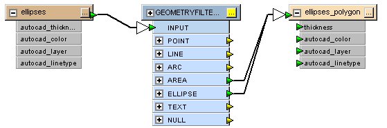
Safe Software Integration with ArcGIS and ArcIMS Just in case you've not run into Safe Software, it's the company behind the Feature Manipulation Engine, FME, what I suspect is the mostly widely-used set of GIS conversion algorithms in the world. For years the company's products have been sold stand alone and as extensions or embedded technology in MapInfo, Autodesk, and other vendor products. Now, for the first time, the company has licensed its technology to ESRI for new extensions that take advantage of more than 75 supported formats for reading and writing within ArcGIS and ArcIMS. ESRI is calling the two products the Data Interoperability Extension for ArcGIS and the Data Delivery Extension for ArcIMS. Be sure you do not get the former confused with ESRI's Interoperability Kits for ArcGIS (which makes them clients to OpenGIS, WMS, and WFS servers) or the interoperability kits offered by Laser-Scan, MapInfo, Autodesk, and Intergraph, which solve a specific nit in sharing data in Oracle. The name of the product for ArcGIS, thankfully, is self explanatory. The Data Interoperability Extension for ArcGIS really means that a great deal of FME is now available "inside" ArcGIS. (Some functions that duplicate ArcGIS ones were removed as were very complex, regional, and third party licensed data formats. There are a few other things for which a full stand-alone FME license will be required as an upgrade.) The integration is still in its early stages, but from a practical standpoint it means that should you have a TIGER or DWG or MIF or GML file in ArcCatalog you can simply open it. The simplest way to do this is to rely on Safe's technology to read the extension and determine what it is and how to open it. (ESRI does have direct read of DWG, but not DWG 2004 for example.) Some file formats aren't that simple, such as MGE. In that case, the user needs to specify some more information (like where the database is). That's really handy functionality, for sure, and adds a whole list of formats that were simply unavailable in the ArcGIS space. And, in ArcMap, users can use those formats just like built in ones, but they are read-only. Now let's move to something even cooler. This is so cool that it was difficult to get Safe VPs Don Murray and Dale Lutz to name it. They started with "dynamic schema mapping," and compared it to "a view in a database." I thought of it as a live filter, but ultimately have decided I like to think of it as a "custom direct read." Direct read, just to be clear, means that the software looks at the data file and on the fly shows it in ArcGIS. A new file is not written, meaning the data is never out of sync with the source. Direct read was first introduced in ESRI products in ArcView 2.0 with the CADReader. Now, let's add "custom." What if you could set the "rules" of the direct read? That is, define a filter that selected just a few layers from a CAD file? Or even merged two or more files together? Or performed the relates out to the correct databases for graphic files? That's what custom direct read means. And, best of all, once you define that filter, you can save it and use it over and over. Such a tool, might in effect create a tool that says, "any time I look at that MIF file, here's what I want to happen to it before I work with it." Another apt analogy, perhaps, is with projection on the fly. A custom direct read is akin to a custom projection on the fly.
And, finally, on to the biggest leap this new extension brings, as far as I can see. ESRI will be introducing Model Builder at ArcGIS 9.0. That's the graphical tool for laying out geoprocessing models (or workflows). A model might say: "Take this file and extract this feature type and project it to state plane coordinates and link it to this database column and merge it with this other file." The workflow is laid out in a series of arrows and boxes. Safe Software has had its version of a similar tool for its conversion tools, called Workbench (above) for several years. Now, you can embed the latter in the former. That means you can: - Have Workbench bring in a MapInfo file, extract just the waterlines, and use it as an input within a water model defined in Model Builder. - Use Workbench to extract the text and points from a complex DWG file, then tap into Model Builder to use some of ArcGIS' power labeling tools (even the Mapplex Extension, if installed) then use Workbench to write the result back to a DWG. I'm still wrapping my head around what's possible, but to understand it, I think about a yellow box (a processing function in Model Builder) being "explodable" to a complex data transformation workflow in Workbench. What that opens up is that any other type of model could be inside that yellow box or any other part of the Model Builders toolbox. And, other companies besides Safe Software, could potentially put their technology inside those boxes. Now, if that makes your head spin, fear not, the other extension, Data Delivery for ArcIMS is much more down to earth. It's basically a repackaging of SpatialDirect for ESRI's Web map publishing solution, ArcIMS. SpatialDirect essentially allows those looking at a Web map to request data from it, in any format supported by FME. The tool clips, zips and ships the resulting data. In more detail, the area of interest is determined and extracted from the data set. It's then converted to the needed format (along with its attribute information), put into a zip file, and either downloaded by or e-mailed to the requestor. SpatialDirect is already in use in governments of all sizes, all around the world. (Canada's GeoBase, which I wrote about a few months ago, uses SpatialDirect.) The main benefit is that requestors of data essentially fulfill their own requests, keeping GIS staff working on their projects.

One new name to me was New Atlanta. The company offers the tools to allow Java developers to work with ArcIMS. In fact, a sample of the tools is on the ArcIMS CD. How did this come about? ArcIMS users were looking for an easy way to use Internet Information Server (Microsoft's Web Server) with ArcIMS and Java and found New Atlanta. After walking GIS programmers through it, detailing the methodology on its website and working with ESRI tech support, New Atlanta became a partner and provides a plug and play way to get started. Visual Learning Systems, the company behind Feature Analyst, which extracts vector features from imagery, has new offerings for ERDAS IMAGINE, and will soon offer a product to work with SOCET SET. A new API at release 4.0 will allow users to include custom tools. A beta is coming in March and will also include the extraction of 3D shape files with elevation from images that are paired with some kind of terrain data (DEM, DTM, etc.). I quizzed VLS' Stuart Blundell regarding what percentage of imagery purchased was used for feature extraction. His estimate was about 10% - the other 90% he noted was exploited, but in traditional ways, as backdrops and using the computer between our ears. He noted that with the higher resolution imagery, shelf lives are shortening (since there is more change to see at higher resolution). That, in turn, he argues, should encourage more automated extractions. Those small features, that demand higher resolution, are playing key roles in homeland security. Consider for example that New York City and Boston like to remove trash barrels and seal manholes during big events. I visited MetaCarta, which is quite pleased with its recent round of new funding. That will help the company explore new areas including state and local government. That had me puzzled for a moment, why would state and locals need a tool that assigns documents to locations on a map? I was reminded that many municipalities, counties, and states have crime and other types of reports on paper or in electronic reports. Exploiting those for patterns, especially in these times of enhanced security, could be very valuable, especially if it takes little manpower. The company continues its work with the energy sector (one of the investors was ChevronTexaco) so that work is clearly moving ahead. MetaCarta was showing its implementation in ArcGIS 8.3 and I got the sense there were more things underway that are not yet shareable. I did learn that there are new faces in Houston and Washington, D.C.
I'm running into more and more people at GIS conferences who are not GIS people. Former police officers are a growing population. GIS Solutions, Inc. used its police savvy staff to build CrimeGIS which is positioned to serve the whole force, from the chief to the officer on the street. It's built on ArcIMS and can turn an existing database into a useable tool. I appreciated the interface. It includes wizards with a few more steps than GIS people might like, but simpler individual panels. "If they can't learn it in 10 minutes, they won't use it," said the representative. And, guess what, police forces use CrimeGIS. A MapObjects-based tool uses the same ideas to put the cases of records that used to travel in the back of a vehicle, onto a CD for Fire Marshals.
One "off the cuff" remark from John Calkins as he moved through the ArcGIS 9.0 demo highlights, perhaps, that GIS users are beginning to use geodata.gov: "This is the first time in my life I've used the Geospatial One-Stop Portal for real data" he noted as he shared his experience from a real project. The data in question was from the National Hydrography Dataset. I spoke with one third party developer who thought ArcEngine was the "big thing" at 9.0. His company "skipped" on MapObjects and started building directly on ArcObjects some time ago. The company has been waiting for ArcEngine to deploy its products. Dangermond made the point that ESRI is not set up to open up its code (that is go "open source") but he did say ESRI products should play well with these offerings. That meshes with the suggestion that ArcSDE might soon run on open source databases.
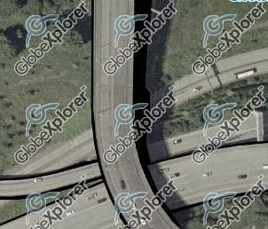
The best giveaway at the show was a knit black ski cap from Computer Sciences Corporation with the CSC logo in red. It was painfully cold during some of the days of the show and attendees were appreciative of the forethought in choosing this giveaway. I learned, and I think I heard this before, that the Border Patrol uses change detection to keep track of new paths used by those who try to smuggle immigrants across the border. I also learned that in addition to the obscured areas in the Washington, D.C. USGS imagery, there are also edits to the Seattle highways' edges of pavement, like this image from Highway 5. The folks at Aerial Express couldn't explain why these areas were obscured.
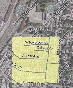
What Happened to the Images in MapQuest?
I learned that MediaMetrix, a company that runs stats about websites, determined that 80% of the users of the imagery on the MapQuest website were commercial users! That is, real estate agencies, engineering firms and shopping mall developers were the main users of this valuable information. GlobeXplorer had been discussing how to charge for this type of use with MapQuest, but hadn't found a solution. So, just around Christmas, GlobeXplorer removed the tab from the MapQuest website and provided a similar, but watermarked image service, on its website. It includes the "moving yellow map box overlay" tool I've noted on several occasions. I asked a GlobeXplorer rep about the implications of the change. "Our phone has been ringing a lot." Those who pay attention to such things might have noticed that in recent months the imagery at MapQuest sported not the GlobeXplorer copyright, but the company URL. GlobeXplorer feels the exposure provided by the MapQuest relationship was very valuable and reports that those who do call (commercial and government) are willing to pay for the unwatermarked image service. GlobeXplorer also offers services via ArcWeb Services.
MapInfo Has Positive Quarter, Raises Expectations The company continues to call Home Depot its largest client, but this quarter added European global insurer Zurich Financial Services. That gives the company hope that its efforts the insurance market will play out successfully.
MapXtreme 2004 will support MapInfo and third party programmers who are building for the desktop or the Web. Recall that one goal in the current development cycle is to base MapInfo's technology (Web and desktop) on the same core. That means, "MapXtreme 2004 will effectively provide Web as well as Desktop deployments via a single development environment using the same object model, reading the same Workspace files and greatly simplifying the use and implementation of location technology in the organization." Any .NET language is usable with the technology. The new version is not just a "port" to a new technology, but adds to the existing toolset of MapX and MapXtreme for developers in general and for deployments on the desktop and the Web.
Service Provider Survey Results Business, despite monies from homeland security being sparse, is good. Just 20% of respondents expected a loss in 2003. Few of the small business heavy samples are outsourcing overseas. The technology used to respond to clients' needs is all over the map. One third of respondents focuses on one technology. Another third provides nearly all custom work. Imagery has become a key part of GIS data sources. A high percentage of service providers buy data on behalf of clients and 69% of respondents are tapping into survey data to upgrade the accuracy of GIS information. Interoperability is not ubiquitous in the work of respondents. Thirty percent identify OGC specifications as "not important at all to their business" but 75% of respondents require interoperability in their solutions some or most of the time. Respondents prefer to explore technology the old fashioned way: either by attending a live demonstration or exploring a hands on demo CD. Fully 80% of respondents who acquired a "free demo CD" installed the software and tried it out.
Letters "I missed the RSS feed poll, but they will not become popular until they are integrated into the email app. "I use Linux, MacOS, [and] Windows and only on my Linux machine is the RSS integrate easy enough for me to use on a regular basis. "Go Linux!" The editor replies: I easily integrated RSS using NewsGator into my mail on Windows. However, I think I'll not purchase the software once my free trial is over. A second reader noted that he too uses NewsGator and that native support in e-mail clients will appear before long. � David Allen of Euless, Texas wrote to share his thoughts on how to spread the knowledge about GIS. "My suggestion to the GIS 'under-informed' is to check out your local community college. At Tarrant County College (Arlington, TX) where I teach, we offer various levels of classes designed to fit a range of student from the rank novice to VBA/ArcObjects programming. Many of our students are not looking for a career in GIS, but just want to know how it's used in their field of interest." � John Armentrout of Northern Geomantics addressed IP mapping, which I raised in a Point of Interest last week. "I have used Visual Route for a time to help me identify who has been on our Web servers and where they come from. It has been very interesting to see in the past few years where people are that 'visit' you. "I have not tried the latest version, but if it's anything like previous versions, it's highly recommended, even if it's just for the DNS lookups and coolness of seeing the tracert [route from you to the URL or IP address given] on the map." The editor notes: This week I also read about Hostip.info, "a community-based project to geolocate IP addresses, [which makes] the database freely available but [...] needs you to put in your city to make it work." � Doug Nebert, Geospatial Data Clearinghouse Coordinator, Information Architect for FGDC/GSDI Secretariat, who I met for the first time last week, shares some unique uses for RSS feeds: "At the FGDC we have been investigating the use of RSS to 'syndicate' "There is an innovative approach to using RSS with web logs (blogs) at www.blogmapper.com. Although it doesn't use any common syntaxes like GML structures for geometries, it does work with RSS and therefore can be used for some creative blogging of the landscape. It'd be great if there were more synergy with GIS tools and standard formats and mapping services!"
Points of Interest Bentley Makes Waves. Bentley announced the acquisition of ESSI, a data warehouse technology company. This technology is typically used in industrial and process plants, but might be used for other areas. But don't expect to see it in GIS any time soon. Bentley also announced a new name for its Bentley International User Conference. It's now called BE, (pronounced "be" if there was any doubt) which stands for "Bentley Empowered." The company release says this reflects the projects and people that use Bentley products to improve the world's infrastructure and increase quality of life. Recall that at one time Bentley was enamored with the letter "V" for Viecon and booth staff, when not working with customers, held up two fingers to show the letter on their hands. Who Benefits from E-911? The Australian Communications Authority (ACA) has introduced a paper on its thoughts on the regulations on the use of location information from cell phones. The country does not have a mandate for phones to identify their locations, nor are location-based services that far along. Still, more than half of emergency calls are from cell phones, but of those only some 30% are genuine. I did read some stats I'd never seen: "US research has found that one per cent of callers to a typical American public safety answering point were likely to benefit from the high accuracy [location determination]." In the EU, it was about 6% who would benefit.
Geography on the Breakfast Table. Recently the folks at Post added a new twist to its letter-shaped Alpha-Bits breakfast cereal. Now it has "cross country marshmallows." That for the uninitiated means a blue "N", purple "E", yellow "S", orange "W" and an arrow and an octagon symbolizing the pointer on a compass. The back of the box includes a tour of the United States with slightly geographic word games along the way. Geography and Pro Football Players. Reader Jim from Penn State shares "an article [...] on a college football recruiting website that analyzes where NFL players come from. There's even some maps made using Microsoft MapPoint. Seemed like the kind of unusual geography-related story you like to put in your newsletter and with the Super Bowl coming up..." It's pretty interesting, and is in fact part of a three part series examining the time honored question "where to good NFL players come from" generally (in part one), by position (in part two), and by salary (in part three).
GPS and Green Cemeteries. Reader Barbara from Hawaii shares "this article in my home newspaper about a Texas cemetery that offers eco-friendly burials... but what really caught my eye (being a surveyor) was the last line in the 3rd to last paragraph: 'They are encouraged to install markers with short biographies of the deceased and must submit a record of the exact location of each grave using GPS equipment.'" VoIP Needs 911. Voice over Internet Protocol (VoIP), a way to route phone calls over the Internet is slowly growing. A company called Vontage is one of the early leaders. AT&T; is entering the fray and, to dispel the real concerns of such networks handling emergency calls, has partnered with Intrado, an emergency services company. The problem is that unlike traditional phone line-based calls, VOIP calls can't easily be reverse geocoded. Intrado will route the calls to the local PSAP (public safety answering point) to keep AT&T; customers safe. Vontage is looking to solve the problem, too and has apparently also worked with Intrado. This is all a bit odd since we've not straightened out cell phone E-911 and there are more users of those than of VoIP.
� Announcements I could report that the first 1,000 professionals to obtain certification will receive core professional GIS training and educational materials worth $335,000 courtesy of ESRI. But, I wrote about it when ESRI announced it at URISA last fall. Laser-Scan announced the appointment of Claire Ellul to a research project at University College London (UCL) on "Extending SQL for 3D Topology." The collaborative research between UCL and Laser-Scan will focus on efficient storage of 3D spatial information in a relational database environment. Indus International Inc. a provider of Service Delivery Management (SDM) solutions announced that it has entered into a definitive agreement to acquire Wishbone Systems Inc., a leading provider of workforce management (WFM) and optimization software. Intergraph Mapping and Geospatial Solutions and the Intergraph GeoSpatial Users Community (IGUC) announced the call for entries to the 2004 Awards for Innovative Raster Analysis Program. STAR INFORMATIC, a European geospatial technology vendor announced that its subsidiary in the UK, APIC UK, will now act as a principal distributor for its successful cartographic publishing software Mercator. Blue Marble Geographics licensed its GeoCalc software development kit for use within ballistic targeting applications developed by LogicaCMG. The ESRI Press book Mapping Our World: GIS Lessons for Educators is a finalist for the Software & Information Industry Association's 2004 Codie Awards in the Best Educational Total Comprehensive Solution category. The book is one of 215 selected finalists out of more than 800 nominees from 600 companies. I gave it a rave review last year. Calgary-based North West Geomatics Ltd. has acquired 100% of the outstanding shares of Pixxures Canada, Inc., a leading online provider of aerial and satellite imagery for Alberta and the continental U.S. Pixxures Canada Inc. was a wholly owned subsidiary of Pixxures, Inc. of Arvada, Colorado. The U.S. Pixxures, headed by Chuck Killpack, will focus on the U.S. market. Xybernaut received a new patent. Xybernaut Way Point intellectual property covers methods, technologies, and applications associated with directing messages or information to specific coordinate locations (Way Points). The information, which could be personalized for individuals or organizations, covers all types of information and data types, including voice messages, audio, video, animation, multimedia, Web sites, documents, text, or e-mail. Doesn't that sound a bit broad to you? DigitalGlobe and Keyhole announced an agreement to provide DigitalGlobe's QuickBird satellite imagery and Keyhole's Internet-based 3D earth visualization solutions to customers. The agreement allows for the use of DigitalGlobe's natural color, two-foot resolution, orthorectified imagery of the U.S. and international cities collected in 2002 and later. The imagery will be integrated into the Keyhole Internet-hosted ASP database as well as Keyhole enterprise solutions, producing global contiguous mosaics overlaid on 3D terrain. Cities already available through this new agreement include New York City, New Orleans, Rome, Paris, and London.
Woolpert LLP acquired Tesseract Technologies, an information technology (IT) firm located in the Washington, D.C., area. Tesseract specializes in GIS and Internet application services to agencies including the U.S. Air Force and the Corps of Engineers (COE). In particular, Tesseract has worked with Air Force Mobility Command (AMC), Air Force Materiel Command (AFMC), Air Combat Command (ACC), and Omaha COE. � Contracts and Sales Space Imaging has been awarded a contract to continue providing GIS in support of the operations of the U.S. Forest Service's Regional Office in Vallejo, Calif., its Remote Sensing Laboratory in Sacramento and the 18 national forests throughout California's Region 5. The contract has a maximum potential value of $1,300,000 over three years. The State of New Jersey has awarded Civil Solutions a New Jersey State Contract for GIS Data Conversion Services (T-1841). The award is part of a multiple line item state contract administered by the State aimed at simplifying the process for acquiring GIS services by State agencies, counties, municipalities, and other members of the State's cooperative purchasing agreement. Space Imaging signed an agreement with Antrix Corp., a division of the Indian Space Research Organization (ISRO), to extend its sales and marketing agreement through 2010. The agreement gives Space Imaging exclusive rights to market and sell data from ISRO's RESOURCESAT-1 (IRS-P6) satellite worldwide outside of India. � Products OziPhotoTool 2.2 has been released and is ready for download. Version 2.2 improves the performance and stability of OziPhototTool and adds a few user requested features. CubeWerx will soon release software extensions that allow ESRI ArcGIS 8 and MapInfo Professional 7 GIS desktop users to fully leverage all the capabilities of OGC-compliant Web Map Servers.
ESRI Canada announced that ESRI released the OGC Interoperability Add-on for ArcGIS. The free downloads deliver support for OpenGIS Web Map Services (WMS versions 1.0.0, 1.1.0, and 1.1.1) and Web Feature Services (WFS 1.0.0) to the ArcGIS Desktop 8.3 products (ArcView, ArcEditor, and ArcInfo). There's also support for GML. (I'm not sure why ESRI Canada announced it, except perhaps that Canada is very active in Open GIS activities.) Telcontar, a supplier of software and related services for location-based services announced the release of Drill Down Server 3.1, the newest version of the premier spatial software platform. DDS 3.1 provides flexible spatial, geocoding, and routing for LBS applications for navigation, fleet tracking, trip planning, real-time traffic information, emergency roadside assistance, and concierge services. PCI Geomatics is now shipping Geomatica 9 Version 9.1. Additions found in the latest Geomatica build upon the software's remote sensing processing, GIS capabilities, hyperspectral tools, and user productivity practices. Improvements to Geomatica 9 Version 9.1 include processing performance enhancements, stronger spatial overlay capabilities, additions to the online help, and for the Geomatica 9 Software Development Kit, several new applications, new interfaces, and added documentation. GeoMicro, Inc.'s AltaMap Version 4.1, is now available. AltaMap 4.1 is a complete mapping platform for your desktop, Internet, and mobile applications. � Events Laser-Scan announced its first partner conference to take place between 11-13 February at Laser-Scan's headquarters in Cambridge. The event will focus on Laser-Scan's partner strategy, partner successes achieved in 2003 and plans for 2004 and beyond. Congressman Trent Franks, a Republican from the 2nd District of Arizona, will be the keynote speaker at the MAPPS Winter Meeting on Friday, January 31 at the Wigwam Resort in Litchfield Park (Phoenix), Arizona. Rep. Franks is in his first term in Congress. He sits on three important committees, Armed Services, Budget, and Small Business. Tele Atlas, a worldwide leading provider of digital map data and location content, will host its Fourth Partner Conference in Scottsdale, Arizona on February 22-24. This is the first time the event will be held in the United States. Visualization and Multimedia: Wireless GIS and Location Based Services is a free one-day conference is soliciting papers and attendees. It's set for 10am - 5pm, Friday March 26th, Bristol Harbourside, UK. The event is being organized as part of the ESRC Transdisciplinary Research Seminars Programme in collaboration with Wireless Europe magazine. The Urban and Regional Information Systems Association (URISA) has begun accepting presentation proposals for the 2004 Annual Conference, to be held November 7 - 10, 2004, in Reno, Nevada. Submissions must be made electronically at www.urisa.org by April 5, 2004. MapWorld events are slated for six locations in North America this spring and about twenty other locations. There are free seminars for non-users and a fee-based User Forum for users. The user event has three tracks aimed at desktop users, programmers, and site analysis. URISA announces that exhibit space is now available for the 2004 MidAmerica GIS Symposium, April 18-22, 2004 at the Hyatt Regency Crown Center in Kansas City, Missouri. � Hires The Orton Family Foundation, a national organization that promotes civic engagement in land use planning, has hired Boston area environmentalist, attorney, social entrepreneur, and author William Shutkin as successor to outgoing President & CEO Bill Shouldice, who has accepted a position heading up the Orton family business, The Vermont Country Store. AirPhotoUSA, LLC, a provider of technology and products for seamless aerial information solutions, announced today that Lynn Hand has joined AirPhotoUSA as Director of Product Management. Acting as liaison between internal operations and the customer, Lynn's role will be to advance operational systems that facilitate AirPhotoUSA's continued rapid growth while maintaining customer relationships. She comes from another aerial imagery company.
Tadpole-Cartesia, Inc. announced the appointment of industry executive Anthony D. Palizzi as business development manager for its geographic data delivery and management business within North America.
Advertise With Us
Contact GIS Monitor is published by: GITC America, Inc.
Subscribe/Unsubscribe |