Letters, Points of Interest, Kudos and Conundrums, Week in Review (Announcements, Contracts, Products, Events, Training, Hires) Back Issues, Advertise, Contact, Subscribe/Unsubscribe If, for some reason you cannot read this document, visit: http://www.gismonitor.com/news/newsletter/archive/051304.php
Adena
MapWorld Baltimore Gavin Lennox, the Group VP of Sales and Marketing opened the meeting and was the first to highlight a theme that ran throughout the day: the core value "customer first." He went on to describe the changes in the company since it went public in 1996. First, he detailed the move from location-centric to location-enabling technology strategy. Second, he outlined the move from a desktop mapping to a business intelligence position. Third, he explained the change in offerings from horizontal products to vertical services. And finally, he recapped the company's move from targeting business analysis to the enterprise. To wrap up, Lennox addressed the company's early success with 17 or so quarters of growth of about 20% and the slowdown after 9/11. Today, he notes, "MapInfo is a survivor and is now thriving." Doug Gordon, Managing Director of Product Management, took to the podium next to address future directions of the company's technology and services. I expected a technical discussion and was surprised to hear more of a business vision. Gordon explained that MapInfo's charge is essentially to help customers get more out of their data. He noted that the "customer first" value was a "a cultural change for the company." The other three core values include collaboration and teamwork, creativity and innovation, and continuous improvement. He shared what the company had learned from its customers, specifically, what they want: - To be experts at their work not at GIS Gordon then revealed the MapInfo version of the pyramid used by several companies, notably, Intergraph, to illustrate its user base (viewer, user, doer). MapInfo uses the triangle to arrange the uses of it technology from most basic to most complex. At the bottom of the pyramid is "locate" followed by "visualize," "analyze" and "model." He went on to introduce what will become the heart of the company's technology: Envinsa. It will help the company move from offering tools to applications to solutions. Envinsa, as a platform, will include mapping, routing, geocoding, and other GIS tools as well as IT tools such as monitoring, measurement, etc. It's a common platform for building products and solutions, is standards-based, supports "integrated data," and is geared to providing solutions across many industries. The rest of the afternoon was broken into three tracks, each with three sessions. The tracks were basically focused on end-users, developers, and those involved in retail site selection. The first session I attended introduced Envinsa. I was the only one in the room who had heard of it. (I wrote about it when it was announced.) I appreciated that the presenter spent a good deal of time making sure we understood Web services before diving into the details of the offering. Basically, as he put it, "Envinsa is MapInfo's new Web services location platform." The second session I attended explored developing with MapXtreme 2004. The best shorthand way to think of this product, for me, is as a product that "replaces and goes beyond MapXtreme Windows and MapX." MapXtreme was MapInfo's Web map server development environment and MapX, a desktop component. MapXtreme's core functionality appears to be a superset of that of MapXtreme and MapX. There's also specific desktop and Web functionality. If you remember that MapXtreme is actually built on the current Envinsa platform, it's not surprising to find such goodies as an OGC Web Map Service client, just like the one in MapInfo Pro 7.5. Slipping out of a session, I had a chance to speak at length with Doug Gordon to wrap my head around Envinsa. I had it right that it's the core technology platform for the "next generation" products, the first of which is MapXtreme 2004. But I wanted to get a better sense of what was inside. Gordon explained it is a platform or framework, or for the sake of discussion, a "container" with lots of things inside. Different users will use different parts. At this point the box is full of what are best termed as molecules, that do a few related things. In time, some or all of the molecules might be broken into atoms that do just one thing. And, further along, it may be possible to license just specific molecules or atoms. At this point, a client would implement Envinsa on its own server to make the services available. The interesting thing to me is how exactly MapInfo will choose to "package" its molecules and in time, atoms. That, Gordon says, goes back to the "customer first" value. Customers will tell MapInfo the best way to group atoms and molecules into meaningful groups. This will be a slow, deliberate change, one aimed at giving those using "traditional products," like MapInfo Professional and MapXtreme, no less in new releases than their familiar, existing functionality. Said another way, MapInfo is undergoing the process of recreating its core, just as Intergraph did some years ago with GeoMedia, and ESRI did more recently with the advent of ArcGIS 8. The final session I attended was titled "6 Ways to Grow with MI Pro" and highlighted six "add-ons" to that product. I saw MapMarker, the company's geocoder in action for the first time. It's a stand-alone product that's widely used with MapInfo and other technologies. Next up was Vertical Mapper, which goes beyond creating grids to performing what I know as "map algebra" - adding and subtracting surfaces from one another. We looked at DriveTime, a tool to figure out how far one could travel along roads, within a set time. TargetPro is used to target locations while SpatialWare allows storing and manipulating spatial data in a database. I was surprised that several attendees were completely new to this idea. Discovery, a several-year-old tool to automate the creation of Web maps, was interesting to the attendees in part because it was easy to use, and in part because of its per server pricing. MapInfo's prices are fair, but based on my knowledge of the pricing options available, not worth exclaiming over. I met a few users during the networking opportunities. One works for the U.S. Postal Service tackling direct mail issues. A second runs a GIS consulting company and was particularly interested in support of standards. A third works on loan guarantees, using MapInfo to just make simple maps destined for PowerPoint. She put her work in the category of "graphic arts." I'm so used to conferences populated by GIS "geeks," being jolted into recalling this technology can "just make maps" was refreshing.

Data Notes
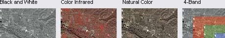
DigitalGlobe this week announced a new product: Digital Ortho Quarter Quads (DG DOQQ) that match the areas of existing USGS ones. The differences between both DigitalGlobe and USGS' offerings? DG DOQQs are (1) 2-ft resolution images built from QuickBird data (vs. 1-meter from USGS), (2) more recent (many USGS DOQQs are several years old), and (3) can be projected as the user requests. Moreover, users can select from black and white, natural color, color infrared, and 4-band Pan-sharpened images. The images are delivered as GeoTiffs. And, for readers in Alaska and Hawaii� the company offers just the continental U.S.
I spoke with a representative to ask a few key questions. First off, how are these DOQQs made? The imagery from the ever-expanding DigitalGlobe library is processed per the user's request. That is, the files are not sitting on a server available for immediate download. Second, is there minimum order size? Yes, there's a four-quarter quad minimum. I think this is a brilliant idea. Instead of trying to convince local government to buy scenes in some mysterious way, one fundamentally different from the familiarity of the DOQQ, DigitalGlobe offers that same chunk of geography, just with more options. To keep things as familiar as possible, DigitalGlobe even follows the USGS naming conventions! For local governments the DG DOQQ offers a chance to update the data without waiting for the next USGS DOQQ cycle. One final thought: I was reading the GITA report recently and was surprised at how many users across all the areas (telecom, gas, water, local government, pipeline, and electric) cited USGS as their data provider. DigitalGlobe is simply leveraging that loyalty. ADCi Teams with Maporama When the rep at DigitalGlobe explained that the DG DOQQs were processed when they were ordered, I was reminded of discussions I had with American Digital Cartography (ADCi) during my first years in GIS. I heard the same story. ADCi had a huge data store, mostly from USGS at that time, and popped out contour and other vector maps in AutoCAD or ESRI format, also based on USGS sheet boundaries, as the customer demanded. I think ADCi's success with that model bodes well for DigitalGlobe. But ADCi had its own announcement this week highlighting its new relationship with Maporama. The desktop services arm of the company, ADC World Map, which is responsible for the ADC WorldMap Digital Atlas, is now a data provider to Maporama. As the data business shifts with the acquisition of GDT by Tele Atlas, it's nice to see some smaller providers finding solid partnerships with overseas partners. Maporama is based in Paris.
Department of Corrections
Marta at GeoMetria noted that I had an error in the URL of that company. The correct URL is http://www.geometria.hu. I fear I've made that error once before, so extra apologies are due to the crew at GeoMetria and readers.

Letters
The article on the disappearance of the LizardTech MrSID viewer prompted several readers to suggest replacements. � Longtime reader Dave Ransier of GeoMicro notes: "AccuGlobe supports .sid. I guess technically this is not a viewer, but since it is free, it can be used as one." � Nick Hutton, of the State of New Jersey's Office of GIS, shared a document that Office produced. "We have recently posted a document that contains several links to free MrSID viewers�" [The document also includes detailed installation instructions for TatukGIS Viewer. -Ed.] � Alex Diamond at Rockware shared yet another solution. "Although LizardTech no longer has a free MrSID viewer available, you can still view MrSID images with third party software like GlobalMapper. "It's nice to know that pro-active third party GIS developers will respond to user demand even if the big companies fail to do so."

Points of Interest More on PacManhattan. I reported on PacManhattan, a real-world version of the video game last week. A New York Times (registration required) report includes key details. First off, the game is a "class project" created by students at New York University. Second, after learning that GPS would not be effective amid the tall buildings of the city, the students resorted to cell phones that allow players to contact their teammates at computer screens. Third, the goal is to one day provide instructions for others to run games in their own geographies. And, the article notes, corporations are looking into the phenomenon of real world games: Intel will test a game in New York in several weeks. And, as we go to press Wired adds its take. Satellite Images for the Masses. Gregory Dicum has a new book (April 2004) titled Window Seat - Regarding the Landscape from the Air. In it, he helps readers tease out the patterns on the ground and in the air. The book includes satellite imagery and a good bit of history and geography, according to an article in the Seattle Times. DARPA Challenge Lessons Learned. The gory details of the DARPA Challenge are now available at the Wired website. A chart documents how far each competitor got and what went wrong. The "lessons learned column" is funny, and, at the same time, highlights the complexity of the task. The Spread of Information. A Brandeis University senior tested how ideas move through the Web by attempting to post a simple meme [a sort of information virus, see below] to a popular blog. One actually picked it up and in time, the meme was the number 3 piece of contagious information according to one blog, and the nickname for the project, "memespread," was the number two "most popular wordburst" on another. From a geographic standpoint I'd argue it was a combination of hierarchical (distribution via "important" connections, such as airports) and contagious (distribution by being close by in physical space) diffusion. One key connection was getting the meme to a second blog via what one person called a bridge. I did not know what a meme was either. I found this definition. Another Proposal for JPEG2000. Algo Vision LuraTech, ER Mapper, Kakadu Software, Morgan Multimedia, and Yakoa announced their endorsement of a common way to use GML schema for storing geo-location information for imagery, within the JPEG2000 format. This definition is an open manufacturer agreement, based on the proposal of Algo Vision LuraTech on GML inside JPEG2000, which has already been adopted as a part of the standard. The paper will also be introduced to the JPEG2000 ISO committee, as the definition makes GML part of the JPEG2000 file format. LizardTech and Galdos began the introduction of another version at the Open GIS Consortium meetings in Ottawa last month. Does IT Matter? Former editor of The Harvard Business Review Nicholas G. Carr, has a new book out, Does IT Matter? (Harvard Business School Press). He wrote an article with that challenge last year and follows up with the details in the new book. He argues of course, that IT does not matter (or perhaps "no longer" matters). The argument, according to the New York Times (registration required) is that at one time IT was scarce and hard to use. Only those who could get it running could take advantage of the power. Today, IT is easy and cheap (like electricity) and there's no special expertise required to use it effectively. So, no, it does not matter. Now, let's make the leap: Does GIS matter? Is it easy and cheap enough to "not matter"? What do you think? The Rand Study Hits the Papers. Recall that the Rand study funded by NGA and USGS and released in March found that almost none of the federal websites with mapping data would really "help" terrorists. On May 10, an Associated Press article began making the rounds of the major papers. I guess since the findings were, "we are pretty safe," this was not breaking news back in March.
Kudos and Conundrums Kudos (concepts we applaud) Coke Classic. Coca-Cola is hiding a cell phone/GPS in 120 cans of its products. When a purchaser finds one, he or she calls in on the phone and agrees to allow Coke (and everyone else, which perhaps makes this a conundrum) to track the can, which must be carried around at all times. At some point the prize patrol will deliver the goods, which may be the grand prize, a sport utility vehicle. I must give Coke credit, the website for the promotion correctly shows a satellite sending out signals to the Coke can, not the other way round! When the tracking starts, the can will effectively send out signals. Join CaGIS as a Student, Enter Contest to Attend ESRI UC Free. The Cartography and Geographic Information Society (a member organization of the American Congress on Surveying and Mapping, ACSM) is running a student contest. The group sends two student members (preferably one undergrad and one grad) to the ESRI User's Conference every year. Deadline to enter is June 15, 2004. Faculty members and employers, please tell your students. You know what a great opportunity this is! Conundrums (concepts we question) Wrong Imagery. According to GlobalSecurity.org several reputable news organizations jumped to some big conclusions when reporting on the devastating explosion April 22 in Ryongchon, North Korea. Several organizations published images of the area claiming they were captured the day of the event when the imagery was several years old. Others published imagery of a neighborhood in Baghdad from April 2003. Says the article, "The probability that one of the half dozen commercial imaging satellites would just happen to have its camera pointed right at the area of the blast in North Korea at the exact time it was taking place and with no forewarning is too small to calculate." There's another factor that the article does not mention: satellite imagery has to be processed so any imagery ideally taken the "day of" an event would likely not appear for several days.
Please note: Material used herein is often supplied by external sources and used as is. � Announcements NAVTEQ has achieved ISO/TS 16949:2002 certification of its distribution services organization in Europe. DDTI announced that its AccuGlobe 2004 GIS software has been downloaded by thousands of users in 114 countries around the World. @Road announced that it received patent number 6,664,922 titled "Method for Distributing Location-Relevant Information Using a Network." At the close of only its fourth month of operation, the GIS Certification Institute announced that a total of 235 individuals are now Certified GIS Professionals (GISPs). � Contracts and Sales PlanGraphics Inc. has been awarded a series of new project assignments that have added $1.1 million to the funded portion of the company's contract vehicle with New York City. � Products
Cadcorp, the developer of the popular Cadcorp SIS - Spatial Information System range of GIS software, is now shipping Cadcorp SIS V6.1. It's a whole range of products I will not document here. PhotoSat Information Ltd. recently announced the release of 10-meter elevation contours covering all of Africa. MetaCarta introduced MetaCarta geOdrive, the geographic text search solution that helps upstream and downstream knowledge workers instantly locate the unstructured text documents they're looking for and then places them on a map, according to their geographic relevance. Airespace, Inc. and Bluesoft, Inc. announced a strategic agreement that will enable enterprises to better track mobile devices for increased productivity and security. Unlike traditional passive RFID devices, the new solution does not require dedicated readers, but rather allows the WLAN network to act as a long range reader, locating wireless devices and active RFID tags anywhere within the network. � Events InfoNetrix will hold the first of four quarterly utility automation and information technology market briefings for 2004 on Field Automation Solutions and data security issues pertaining to Field Data Devices (FDDs). EnergyCentral.com, the Denver-based energy information portal serving up-to-the-minute market information for the global power industry and utility marketplace, will host the first of the online events on May 26, 2004. � Training TerraSeer announces its 2004 Spatial and Temporal Data Analysis Training Series. Learn from experts how to extract knowledge and make better decisions with Space-Time data. � Hires nCircle, a provider of enterprise-class vulnerability management solutions, announced the appointment of Elizabeth Ireland as the vice president of marketing. She was at MapInfo for 10 years. Orion Technology Inc. announced the appointment of Faizal Hasham (B.Sc., M.Sc., MBA) as the company's new Business Development Manager. Hasham will be responsible for strategic market development in the United States. Stephen L. Root recently joined Woolpert LLP as a photogrammetry project director.
Advertise With Us
Contact GIS Monitor is published by: GITC America, Inc.
Subscribe/Unsubscribe |