Letters, Points of Interest, Week in Review (Announcements, Contracts, Products), Back Issues, Advertise, Contact, Subscribe/Unsubscribe If, for some reason you cannot read this document, visit: http://www.gismonitor.com/news/newsletter/archive/061903.php
INTERNATIONAL RIGHT OF WAY ASSOCIATION ANNUAL CONFERENCE This week I was asked to speak about GIS at the International Right of Way Association Annual Conference. What's interesting about this group is that its bounded by a single legal idea, the right of way, a piece of property used for the common good. Right of way professionals work with all of the issues relating to finding, legally accessing, safely using these properties and effectively compensating their original owners. Members of this diverse group are well versed in such topics as negotiations, land management, appraisal, relocation assistance, the environment, property management, real estate law and engineering. Those topics are reflected in the program, which includes several sessions on wireless (Managing a Wireless Project: Implementing the Principals of a Successful Plan and Achieving Positive Results), relocation (Relocation D.C. Squares Game Show), appraisals, environmental issues and more. One topic I thought interesting: Is mold the new asbestos for property owners? As I walked around the show floor and spoke with vendors - a LiDAR provider, a property management services company and an engineering firm, to name a few - each one was in some way tied into GIS. The diversity of the providers demonstrates the flexibility of geospatial technology to play into so many of the steps involving right of way issues. I noticed that all of the GIS or mapping related demos were running in a browser. Times have changed! As for my presentation on GIS for the Right of Way Professional, I'm pleased to report a good turnout. The single most popular question, and this was echoed by Wendy Lathrop, a long time IRWA member, is always the same: "How do I convince my manager to buy into GIS for our right of way work?" Vendors, and others might want to address that question.

EMERGING TECHNOLOGY SUMMIT At the beginning of June I attended the Emerging Technology Summit II: Spatial Web Services, the second in a series of ETS workshops/panel discussions hosted by the Open GIS Consortium (OGC) and the Geospatial Information Technology Association (GITA) in Vienna, Virginia. As companies position themselves to pull out of the current economic slump, now is a good time to store up momentum by taking an active role in plans for what should happen next. According to one speaker, the current economic and political environment has bred a greater willingness and opportunity for integration than ever before. Addressing the two-day summit, OGC President David Schell and GITA President Karen Hurley opened the event. "Rapid change in the geospatial technology industry, more so in recent years, has put the entire community in a state of flux," said Schell. Many of the interoperability issues have been solved, he feels, but we now face barriers that aren't technical. Former Wyoming Governor Jim Geringer, who presented a keynote address, remarked that a GIS is a simple way to view a very complex system. While recognition and awards are plentiful when it comes to the efforts of response teams, Geringer pointed out how tough it is for individuals and teams to be recognized for good prevention work. Data sharing and usage, he argues, is prevention, and it is important to view it that way. Geringer closed by confirming that we should all agree that prevention is best way to go. He stressed that we are all responsible for promoting the importance and value of cohesive data. He echoed Schell's introduction, noting that technology is actually the easy part of the equation-the difficult part is to change the underlying culture. Tim Berners-Lee delivered the second keynote. Credited with the invention of the World Wide Web in 1989, he currently holds the 3Com Founders Chair at the Laboratory for Computer Science at the Massachusetts Institute of Technology. Note that Berners-Lee is not the inventor of the Internet-he credits Vint Cerf and Bob Khan with that creation. Cerf and Khan defined the Internet Protocol (IP) by which packets are sent on from one computer to another until they reach their destination. To set the stage, Berners-Lee outlined the relationship of the Web to the Internet. "The Web exists because of programs which communicate between computers on the Internet, and could not exist without it [the Net]." The open source movement, and dissemination of data for the greater good are the relational ties between the geotechnology community and Berners-Lee's broader view of the Web. The first stage of development of the Web is complete-HTML is everywhere, allowing surfers to view huge amounts of data in near real time. But HTML is just HTML. While spiders can crawl through it, index it, and locate it, there still isn't enough "power" to take the next step of better data, even faster. Berners-Lee outlined a vision for the Web in which organizations will define, or model, the meaning of a term or a word, and upload that definition to their sites. Once "registered" with W3C, or another body, they will have to agree (via legal paperwork) that a definition cannot change. More power is available once these words/terms/language, etc. are defined. Berners-Lee believes that all data posted to the Web should be defined in order to truly expand the Web's capabilities and reach. He also commented that organizations should never change links once posted! Search engines = serendipity. The Semantic Web (the software element of the Web) connects people and information across boundaries, and connects applications to concepts. It is currently in its 2nd stage, which is somewhere between "completely rough and under development" and "embraced by the vast majority of users." Web services connect software program to program, while the Semantic Web makes connections from one piece of data to another. Rule-based systems can be formally modeled (mathematically) within the Semantic Web, allowing for much better return on the data we currently have. (As an aside: I noticed that Berners-Lee didn't deliver his presentation using PowerPoint, so I asked which OS and other equipment he currently uses. He explained that W3C has a free tool for building HTML slides with PNG and SVG out of a single HTML file. Berners-Lee runs a Macintosh PowerBook G4 with Mac OS X, and normally uses the Safari browser. He is also an advocate of Fink, and runs Amaya, a W3C editor/browser, under X11.) OGC President David Schell closed the Summit noting the importance of infrastructure. We need to focus on infrastructure, he suggested, because it will hold the market together and allow progress. By retaining focus, and watching policy, we can grow the Web into its next iteration, complete with a spatial component. A paper called "The Role of Web Services for Spatial Data Delivery" by Ed Parsons of Ordnance Survey is available from GITA. More information on the broader issues playing out in the Web services arena is available at webservices.org.

CHANGE AFOOT AT LASER-SCAN To be quite correct, the plan is to put Laser-Scan into "administration for controlled disposal." "Administration" is similar to bankruptcy in the United States. An outside administrator keeps watch over the company as it's sold or dismantled. There are a few ways this might play out: another company might buy Laser-Scan, the employees might take it over, or it might be dismantled, though I believe that is unlikely. Laser-Scan is one of the older GIS companies, founded in 1969. Joel Orr, in the 1969 entry of his CADD and PLM timeline notes "All kinds of stuff in Cambridge, England, leading to Medusa, RUCAPS, GDS, LaserScan [sic], and other amazing systems." Another industry veteran commented that Laser-Scan was "one of the small set of original companies along with Cambridge Consultants, CADCentre and ARC that spawned 'The Cambridge Phenomenon.' Their original product was a gigantic workstation display about 60" diagonal!" If I remember my history lesson from a former UK colleague, the original products did have to do with lasers, so the name made sense, at least back then. Today Laser-Scan is known for its products aimed at national mapping agencies, cartographic generalization tools, and its new (2002) product Radius that works "within" spatial databases (such as Oracle) to speed-up processing. Cost controls on Laser-Scan showed progress from a �0.4m loss last year to a �0.3m trading profit this year. Still, while Radius found critical success, sales were not as high as expected, according to the announcement. YEOMAN determined it unlikely that Laser-Scan would break even in coming months, and decided to part with the organization. While I recognize the business decision being made here, I question putting all the company's assets into the mobile navigation basket. The document notes, "The convergence of positioning and communication in consumer devices has been slower than the industry expected, but we believe that these devices will become more widespread in the future�" The document goes on to suggest that the company has the opportunity to become a "leading European telematics service provider." Also there is a comment about, "the anticipated consolidation opportunities in European telematics." Finally, in the discussion of TravelM8, YEOMAN's existing mobile navigation business, the announcement acknowledges the current economic challenges in this arena, but feels that the company, "using the resources from disposals [of Laser-Scan and Brookes and Gatehouse] intend[s] to play a substantial role in the industry consolidation." The goal then, for the "new" YEOMAN Group is to buy, or be bought, to become a major player in this space. My concern, and I expect YEOMAN's, too, centers around having enough funding to keep the company going, wisely acquiring technologies, and staying the course until telematics revenues jump. It might be a rocky road: as we go to press a new report from Metrinomics, based in Germany notes the reluctance of drivers to purchase naviation systems.

BOOK REVIEW: THE DESIGN AND IMPLEMENTATION OF GEOGRAPHIC INFORMATION SYSTEMS I'll offer a different title for their book, to illustrate its usefulness, borrowing from a famous book for new mothers: What to Expect When You're Expecting a GIS Project. The book covers all of the key "gotchas" that people who are implementing systems are likely to encounter - from needs assessment through database design, the use of remotely sensed data, conversion, and the reality of involving people in the process. It's clear from the discussions and examples in each chapter that these two have "been there, done that." The authors have provided plenty of examples of "typical" situations, but perhaps a future edition could include some "atypical" solutions as well. In their "nitty gritty" discussions of data models, the authors have avoided using a particular vendor's data structure; instead they use the Spatial Data Transfer Standard (SDTS) as a starting point. While this does make the book vendor neutral, it's very likely that those who implement systems will never see or use SDTS very much, if at all. On the other hand, I appreciate the fact that the authors have stayed away from detailing vendor products. They do, however, prepare the reader with solid information for the GIS evaluation and selection process, such as understanding the versions of a product (2.5, 2.6, 2.7, 9, etc.) and exploring whether a new version is all new (which might be a red flag), or whether it is simply a light "update" (which is likely to be fairly stable). When it comes to standards, the authors advise, "Any product you are considering should be compliant with at least one of the two standards [SDTS and OGC], and the software vendor should be an active participant in these groups." Some of the most valuable parts of the book are the anecdotal tales. One describes a situation where the budget chief wanted to know about the money saved by laying off 17 employees and replacing them with a GIS. The GIS manager had to scramble to show that the claim of 17 positions to be eliminated had never been made. Also included are "How They Did It" segments that relate stories of particular implementations. While interesting, I found them difficult to read due to the compressed text. My only other suggestion involves the "Internet Resources," at the end of each chapter. In Chapter Two, the authors explain how things move around on the Web, but still provide a number of links, at the end of each chapter. One of these happens to be a "dead" link to to one of my lists that was once housed at www.tenlinks.com. It seems to me that book publishers should simply abandon the use of URLs in printed publications and provide a website where active links can be found. On the whole, The Design and Implementation of Geographic Information Systems is an effective reality check for those looking to implement a GIS. It's not too technical for a manager or a student, and lays out, in plain language, the basics of what's ahead. And, perhaps equally importantly, the authors touch on each of the basic hallmarks of GIS: hardware, software, data, applications, and people.

LETTERS "� 'Shelby County Makes a Choice' and the article that is linked to it appears to highlight a situation in which one state-supported university in Indiana (Ball State) successfully expropriated work from another state-supported university (Indiana University Purdue University Indianapolis) by proposing a solution with a lower price tag. The scope of work was delivering 3rd party GIS software, creating some applications, and potentially delivering some other (undefined) services. The note provoked several comments at our office. Here are three: "When does higher education cross the line from providing education and research to providing commercial GIS consulting and data conversion services that are in competition with the private sector? Should a university compete with the private sector using a business infrastructure (phones, email, internet, office space, utilities) that is supported by taxes, part of which are paid by the same companies with which it competes? "Your note compares $8,000 for software and $29,000 for enhancements from one organization to $245 for software and $18,000 for enhancements from the other. Without investigation, a reader might assume that the software and enhancements are the same from both organizations - that the only difference is cost. It is my understanding, however, that both software and services differ substantially between the proposals. "Given that the two proposals differ in price and scope, then fundamental consultancy questions must be asked and answered to understand the value of either solution. What is it that the end-user organization (Shelby County, Indiana) wants to accomplish? How well will the proposed solutions help the county accomplish its objectives? An objective comparison cannot be made without an informed context from which to view the two solutions, regardless of the price tag." The editor notes: I've contacted some of parties involved with this effort and hope to provide further details next week. Stay tuned! � Ed McKay of NOAA wanted to ask for some input on Data Content Standards. "It just so happens that's what I've been working on � at NGS, specifically, the Geodetic Control Data Content Standard for the FGDC Geospatial One-Stop E-gov initiative. "We've completed DRAFT #2, and it's up on the Geospatial One-Stop website. What I'm interested in doing is 'getting the word out' that it's there, and we're actively soliciting comments (by mid-July)." � Unni Krishnan, Technical Director, at GISTEC in the United Arab Emirates, added some thoughts to my data model discussion. "I believe there is a need to differentiate the data modeling process as data-driven and applications-driven since it has an important bearing on the resulting data model. This will clear the confusion whether data models could be used for data sharing or not. The data models developed by FGDC, OGC, and CADD/GIS Technology Center (Tri-Service or SDSFIE/FMSFIE data model) are necessarily more generic and hence could be utilized for data sharing. But many of the data models from the software vendors are developed from an application perspective and consequently data sharing is not one of the primary objectives. "Another trend that needs to be noted is the move towards data modeling using 'object' technology, which allows a more realistic and intelligent representation of the real world. Though people have been developing data models for several years, the object data modeling approach practiced today adds a completely new dimension to the subject." � Thomas Conry, GIS Manager of Fairfax County, Virginia, also wrote to add to the data model discussion. "Thank you for the useful, understandable overview of data modeling. I would like to extend the discussion in your article and data standards. "Your article discussed reference schema and data models - as did your interviewees, but an important point did not come through clearly:"If your data does not model the details you need, reference schema cannot supply it. For example, if you have defined dual centerlines and your neighbors only have single centerlines, you cannot build a seamless dual centerline dataset for your region. You will have to go with the lowest common denominator if you want the regional set to be consistent. Or if you define road status as paved/unpaved/gravel/dirt and your neighboring jurisdiction defines road status as existing or planned - you cannot merge the data - there are no commonly defined domains. "My favorite analogy is to photography. If you take an out-of-focus picture, you cannot take a picture of the picture to put it into focus. Why? Because the data necessary for the in-focus picture were not captured in the photo. Thus taking a picture of the picture (using a reference schema) will not put it into focus. If you[r aim is] to build a collage of photos and have them all look the same, then you will have to have all of them out of focus (degrade some of your data - the in-focus shots to the lowest common denominator). "Therefore it is important for there to be common definitions and data elements for key GIS data. Your interviewees touch on some of the issues with data standards, but when the goal is to assemble the data into a useable, regional or even national resource, there must be agreement on key elements. Thus, efforts to define a Minimum Essential Data set for shared data makes a lot of sense. Users would know that they can keep whatever additional data they wish, but for key elements, there is a common standard." � Andrew Zolnai of ESRI offered another interpretation of Paul Ramsey's analogy that compares open source software to a restaurant providing the recipe along with the meal. "Can Paul Ramsey's words not be read differently? I know of no restaurant that offers recipes as suggested, and my restaurateur friends say they'd go broke if they did... Gourmet Magazine actually runs a pro-bono service, whereby subscribers can request a recipe from restaurants, and they will post them if authorized - a clearing house of sorts." The editor replies: Why does GIS Monitor use food analogies so often? First peanut butter and jelly and now this! I took the recipe issue to my food/restaurant expert (and best friend) Melissa Barger, who has two degrees from a leading culinary school, Johnson and Wales in Rhode Island, and years of experience. She replied: "I found the restaurant analogy very apt; as a former restauranteur, I thought it perfectly captured the open source paradigm. When I eat at a restaurant - whether it's McDonald's or the Ritz - I am buying a great deal more than the recipe for my lunch. At McDonald's, I'm buying the speed of service; the reliability of the product from site to site, even across the globe; the low price; and a child-friendly room that maybe even has a playground for my kids to attack while I munch my burger. At the Ritz, I'm buying the tablecloth, and the tuxedoed waiter, and the gracious atmosphere. I might even be buying the chance to rub elbows with other movers and shakers, rather than sugared-up little kids. Sure, I'm willing to spend more at the Ritz, and partly I'm spending more because their burger's better, but the recipe for that burger is not what is bringing me into either restaurant. "Want more proof that it isn't proprietary recipes that make or break a restaurant? Surf on over to Amazon, and take a look at the cookbook bestsellers. Of the first five cookbooks listed at the moment on the Cooking, Food, & Wine page, four are written by restaurant chefs (and a bartender, in one case), revealing the recipes that made their restaurants famous: The Arrows Cookbook, The New Legal Sea Foods Cookbook, The Lobster Roll, and The Cocktails of the Ritz Paris. Again: it isn't the recipes that made these places successful; in fact, revealing the recipes turns out to be a brilliant marketing strategy. If you like The Arrows Cookbook, head on up to Ogunquit Maine and check out the restaurant! The relationship between these cookbooks and their restaurants is synergistic; each promotes the other, leading to more sales and higher name recognition for both." � Gary Quinton notes some interesting behavior from Microsoft when faced with open source in Europe. "I found it ironic that after losing two large German cities to open source software Microsoft is crying 'unfair trade advantages" against IBM LINUX and others." � Dmitri Rotow of Manifold feels I didn't provide both sides of the open source issue last week and tries remedy the situation. "Regarding your recent GIS Monitor on open source... "I think you gave only one side of the story. It's easy to feel happy about open source if one assumes away all of the negatives. Your reporting would have been much more balanced had you presented more significant notes on the disadvantages of using open source. Like almost all things, using open source has its advantages and its disadvantages and whether it makes sense or not to use it has to be considered on a case-by-case basis. "There are several disadvantages, some of which are aspects of higher life cycle costs. These vary, of course, depending on which open source product is being discussed. Because of the disadvantages listed below, open source products for the most part have become popular as black box, server-side appliances, not as interactive applications. "If we keep in mind the following is a summary that applies in general to open source products, with the proviso that one can always find a counterexample to a given point, the main disadvantages are: "Restricted choice - In virtually every area of software there are dozens if not hundreds or even thousands of choices for different commercial packages, but rarely are there more than one or two, if any, open source options." The editor notes: Due to length of this letter I've posted the remaining points, and my response, online.

POINTS OF INTEREST Jargon Fighter. The New York Times reports that Deloitte Consulting developed a free software program, Bullfighter, which identifies jargon in documents. The idea is to help marketers trim out words that sound great, but bring nothing to the reader. One comment from an outsider: odd that a consulting firm should develop the application, as these firms are often creators of jargon in the first place! The firm held a contest to identify jargon and came up with some 10,000 terms. Korea Exports GIS. Korean GIS companies including Korea Telecom Data, GeoSoft, and GeoMania are looking to offer their wares in Japan and China according to Korea IT News. Future targets include the Middle East and Latin America.
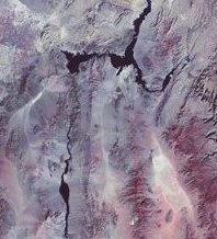
Small Satellites, Big Impact. The BBC reports that three satellites belonging to Nigeria, Turkey, and the UK, will be launched from the Plesetsk Cosmodrome in Russia next month. These satellites and another owned by Algeria, which was launched last November and is already operational, are part of Disaster Monitoring Constellation, a group of micro satellites dedicated to disaster monitoring and regional mapping. These satellites are a bit different than others: they will cover the whole world every day, and they are inexpensive and small. At 90kg each, the satellites will provide 32-meter multi-spectral imaging, covering 600 x 600km areas. The participating nations have 95% access to the "birds" and have donated 5% to international disaster relief through the charity Reuters AlertNet. At right, a portion of a 600x600 km area stretching from Los Angeles up to the south-eastern region of San Francisco and across Nevada and New Mexico to Utah and the Grand Canyon from the first satellite launched in the constellation. Geolocation Growth Still Slow. The New York Times reports on the slow growth of geolocation technology, that is, determining and using the physical location a Web surfer. While organizations like Major League Baseball and RealPlayer use it to keep those in "unauthorized" locations from watching the game or downloading music, there have been few sales to retailers who might use it to target different buyers in different geographies. The good news: the group of players in the space has seemingly remained the same since I began covering the topic three years ago. Covered in the article are: Digital Envoy, Quova, and Akamai. For a price reference, consider that a Boston based online ad network pays $5000 per month to use Akamai's technology to focus ads for one of its credit card vendors. Mapping Websites Hot in Europe. Nielsen//NetRatings research shows that online map websites in Europe, such as multimap.com and streetmap.co.uk in the UK, mappy.com in France, map24.com in Germany, and karthotellet.com in Sweden have experienced a growth of almost 300% in the last 12 months, making the online map sector one of the fastest growing Internet sectors in Europe. An online article about the report suggests that the popularity may encourage fee-based options down the road. No Europe-wide website has yet risen to the top. New Technologies Issue Coming Soon. GIS Monitor will kick off July with a New Technology issue. Your contributions about new products, techniques, services, and trends are welcome.
� Announcements As a part of the development of the Italian Cartographic Reference System, the Italian Ministry of the Environment has developed, in collaboration with Planetek Italia, a public website, allowing unrestricted Internet access to various types of maps and photographic images covering the whole of Italy. It uses Image Web Server. Applied Geo Technologies, Inc. (AGT) has launched a new online storefront. Iunctus Geomatics formed a strategic alliance with TELUS Geomatics, a division of TELUS Communications Inc. to facilitate the management and distribution of satellite and airborne imagery. This agreement will incorporate the use of Iunctus's TerraEngine software to manage the distribution of images on the TELUS's GeoExplorer application. GeoExplorer is a secure Web-based application that allows users from companies of all sizes to view, edit, and manage secure data on maps from the office, home, or on the road. NovAtel Inc. a positioning technology company, and Leica Geosystems have signed a strategic co-operation agreement for the joint development of new Global Navigation Satellite System (GNSS) technologies. An initial announcement was made in February 2002, but the scope of the agreement has now been expanded to include future opportunities with any Leica division. DMTI Spatial, a provider of map and address data, has teamed up with Orion Technology to give customers interactive access to DMTI's Canadian spatial data products over the Internet. This Web-based portal will be launched on June 12th and loaded with DMTI Spatial's latest version of CanMap Streetfiles. Ekahau, Inc. has enabled the first location-aware library navigation system deployed by the Oulu University Main Library, Finland. A wireless PDA-based system called SmartLibrary helps users find books and other material from the library collections. Xybernaut Corporation announced it has been granted a patent by the Japan Patent Office (JPO) for leaving and retrieving messages and data of all types at specific locations - such as coordinate way points - within a commercial mobile radio service (CMRS) provider network or other networks. Directions Magazine presents a vision of why the current Oracle/PeopleSoft discussions will have a major impact on GIS down the road. ImageSat International N.V., announced that the company's lightweight, high-resolution Earth Resources Observation Satellite, EROS A, has proven its ability to image a target from several angles in the same orbital pass. Leica Geosystems GIS & Mapping announced that Planson International Corporation has become the first U.S. non-exclusive reseller of Leica Geosystems' new ESRI Extensions products (Image Analysis for ArcGIS and Stereo Analyst for ArcGIS). The Open GIS Consortium, Inc. (OGC), presented Edric Keighan, Peter Vretanos, and Bill Lalonde, all of Canadian software developer CubeWerx, with the fifth annual Kenneth G. Gardels Award. The Gardels Award, a gold medallion, is awarded to individuals who have made an outstanding contribution to advance the vision of the OGC. Intergraph Mapping and Geospatial Solutions, in collaboration with the University Consortium for Geographic Information Science (UCGIS), announced a GeoMedia research grant opportunity for UCGIS members. The grant is open to any UCGIS member who uses or intends to use Intergraph's GeoMedia technology as the foundation for GIS research. The GeoMedia research grant will award $5,000 (US) cash funding and a $50,000 software donation in recognition of an exceptional and innovative applied research proposal submitted by a UCGIS member. Televigation won first prize with its TeleNavTrak in the business and productivity category of Motorola's CodeMeMoto developer contest.TeleNavTrack is a GPS-enabled tracking service featuring an electronic timecard that allows field workers to enter their work hours electronically, job dispatching that allows new job orders to be sent directly to field workers' mobile phones, and a turn-by-turn navigation feature. Getmapping plc and Ordnance Survey have resolved their outstanding legal dispute concerning the development of the imagery layer of OS MasterMap. Getmapping has now withdrawn all of its claims and has paid a six-figure sum of money to Ordnance Survey in full and final settlement of the matter. I covered the lawsuit here.

� Contracts and Sales MapInfo Australia signed an enterprise agreement with the NSW Rural Fire Services (RFS). The software licensing agreement, totaling AUD$1 million over four years, will play a critical role in fire management for the NSW RFS.

� Products CompassCom Inc. released Version 4.0 of its CompassTrac and CompassFDE Automatic Vehicle Location products. Red Hen Systems, Inc. released VMS Mobile, an add-on video module for its MediaMapper and MediaMapper ELITE products. Users equipped with an off-the-shelf digital video camera and GPS receiver can quickly and easily collect the field data necessary - without cables - to build digital, interactive maps using spatially referenced video. Digital photographs, audio files, and text documents can also be linked to their location, enabling users to build robust, information-packed maps with remarkable ground-truthing richness, detail, and accuracy. Haestad Methods released WaterGEMS version 2.0 for ArcGIS, geospatial water resources management software for the global engineering community. Deneba is taking pre-orders for a $599.95 GIS Mapping Edition of Canvas 9, which adds native support for GIS data including shapefiles and GeoTIFF image files. The product supports 150 projections, measures in geographic coordinates, and automatically aligns overlapping layers. Canvas 9 is being released simultaneously on Mac OS X (10.2 or higher) and Windows (NT/2000/XP or above) and is due to ship on June 30. manifold.net announced that Manifold System Release 5.50 has been enhanced with over 100 new features in a free Service Pack. The company also announced a new $250 feature that adds street address geocoding for eleven European countries - this involves buying a copy of MapPoint 2002 from Microsoft. MapInfo announced that it has acquired the exclusive rights to develop and distribute Marconi's Vertical Mapper, a grid and 3D generation solution for enhanced location analysis. It is now available in Europe.
ADVERTISE WITH US
CONTACT
SUBSCRIBE/UNSUBSCRIBE |