|
2005 June 23
Contents
|
This issue sponsored by:

|
Departments
News Briefs,
Back Issues,
Advertise,
Contact,
Subscribe/Unsubscribe
If, for some reason, you
cannot read this document, visit:
http://www.gismonitor.com/news/newsletter/archive/062305.php

Editor's Introduction
If you did not receive last week's issue or any other issue, please remember that you can always download past issues from our archive.
***
In this week's issue of GIS Monitor I report on my conversation with the founder and CTO of MetaCarta. I also bring to your attention an article on digital maps and do my usual round-up of industry news from press releases.
— Matteo
MetaCarta Bridges the Gap Between Text Searches and GIS
Let's say that you are searching for vineyards that grow Red Malaga grapes or for East Coast swing dance classes. You might want to look all over the world for these vineyards or classes and plot their locations on a map or you might want to restrict your search to a certain area — say, within 100 miles from Portland, Oregon. In most cases, search engines such as Google and Yahoo — which find alphanumeric strings amidst hundreds of millions of online documents and rank these documents by relevance — are of little use to you for this kind of search. The exception are those cases in which the text on a Web page explicitly ties an object or an event to a particular geographic location — such as "The art gallery is at the corner of Olive Street and West Broadway in Eugene, Oregon" or "The concert took place last October at the Teatro Verdi in Pisa, Italy." Even then, the location information might be several sentences or even paragraphs away from the term you entered in the search engine, so you would have to do a lot of reading to find it. Conversely, geographic information systems are ideal for plotting on a map the known locations of events or structures that have already been selected and stored in a database.
MetaCarta bridges the gap between these two processes: it scours text documents for search terms and for associated geographic references, even when the two are separated by much verbiage that is not relevant to the search. The software then continues to search the documents for further cues that will allow it to narrow down the geographic area of interest or increase the relevance ranking of a particular find. For example, finding the fragment "... saw the statue at the modern art museum in Springfield..." MetaCarta is able to report that there is a modern art museum in a town called Springfield and that the most frequently cited Springfield is the one in Illinois. Then, upon coming across the fragment "... as we were driving through Connecticut..." in the same document, MetaCarta will refine the search and assign a much higher probability to the possibility that the Springfield in question is, in fact, in Connecticut rather than in Illinois. In another example, a reference to "lot 28" in the middle of a document might be useless as a geographic reference... until MetaCarta associates it with "oil fields" and with "Pensacola, Florida" in the same document.
John Frank, MetaCarta's founder and chief technology officer, describes his company's goal with the phrase "everything is geographic." This is not a common phrase, he points out, nor is it technologically true today. MetaCarta, according to Frank, aims to expose explicitly the geography that previously was only implicit. "You can take anything that is digital and expose it as being geographic, including many situations that people have never treated as geographic," he told me. As Frank sees it, the main reason that location-based services have not yet taken off is that there just isn't enough available geographic information. MetaCarta can change this, he thinks, by extracting the needed information from existing sources.
MetaCarta, Frank says, is for people — such as geologists, biologists, and intelligence officers — who are interested in much richer geographic information than can be found by using other text search engines. "They are looking for descriptions that require prose, discourse" — in other words, unstructured content, as opposed to the structured content found in directories and databases. This kind of geographic search, according to Frank, "is the future, because the structured content is small and exhaustible."
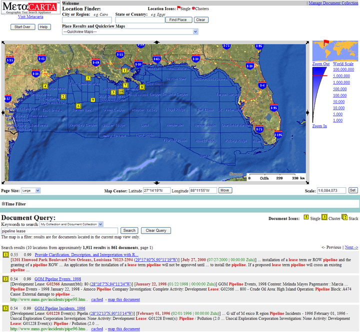
Click on the image to enlarge it
I asked Frank how his phrase, "everything is geographic," differs from the phrase "everything happens somewhere," which is common in GIS circles. (In one instance I found, the writer gave the following, excellent list of examples: "Commerce, potholes, crime, education, snow plowing, pollution, recreation, fires, poverty, floods, drug abuse, traffic jams, medical care, death, and taxes all happen somewhere.") His answer was that his phrase encompasses much more than just events. A search result "could be the digital readout from a pump."
"One of the reasons that everyone but Google missed that search was going to be a big deal," Frank told me, "is that relevance is a very subtle thing. People [rank information by relevance] without realizing it. To build software that thinks about relevance is subtle. It is what artificial intelligence (AI) is all about. When is something relevant to a particular person's task? For example, a letter carrier needs to know where to drop off mail and where he might encounter a dangerous dog along his route." If all of the trouble tickets written by letter carriers in a given area were entered into MetaCarta, Frank explains, the software could allow carriers to search for, say, any trouble within ten feet of their route. These trouble tickets would be unstructured narratives, not georeferenced entries in a database. "There's ten times more information of the unstructured narrative type than of the structured type," says Frank.
IDC — a market intelligence firm in the IT and telecommunications industry — and several other analyst teams have determined that people make decisions mostly on the basis of unstructured information. "Most of that information," says Frank, "contains rich geographic information." GIS require structured information and text search engines know to generate a set of results from keywords but not how to georeference them, even when the required geographic information is present in the documents.
Search engines such as Google and Yahoo rely on natural language processing, a branch of AI. They use a process called "entity extraction" — that is, they determine whether a word is, for instance, a verb or a noun. They do not determine the meaning of a word, which is very context-dependent. MetaCarta differs from these text-search engines in that it interprets words and phrases to identify and return geographic references. For example, MetaCarta can distinguish between the adjective "apt" and the French town of "Apt."
"If I mention the junction of the Mississippi and Ohio rivers" Frank continued, "you can easily find that on a map. You can also search for it in Google and you will get 623,000 hits and the first has satellite imagery of the junction. For each additional location description in that area, you will find more great hits! However, if you try searching for 'Miller City, Ohio,' which is near the river junction, you'll find many hits that were not included in the search for 'junction of Mississippi and Ohio rivers.'" MetaCarta, on the other hand, would have found them in a single search.
MetaCarta displays search results in two ways. On a map, it generates labels, "the way an old-fashioned cartographer might have done," says Frank. Below the map, the results appear much the same way they would in a search engine, ranked by relevance. Each entry is preceded by two numbers, both ranging from 0 to 1: the first one indicates the relevance ranking of the result, the second one estimates the confidence that the location found is in fact the correct one. Only the results with the top ten scores for relevance appear on the map and on the list. The map display allows users to change the scale of the map and its center, thus controlling the geographic extent of the search, and to "drill down" to read what the referenced documents say about a particular place.
If you found a reference to "Bob," you would need a unique identifier, such as Bob's social security number, or a collection of specific information (such as age, address, etc.) in order to identify the specific person being referenced out of the hundreds of thousands of people with that name. However, for time and geography, Frank explains, it is possible to "resolve" the meaning of the terms and then use that meaning to enhance the search result. For example, it is highly probable that the word Tokyo, in any context, refers to the city in Japan with specific coordinates.
At the core of MetaCarta is the statistical analysis of the contents of millions of documents — including Web pages, journal articles, and military intelligence traffic. This is a complex task because geography, as Frank explains, "is the essence of the 'long tail': every time someone bolts down a piece of equipment it is a new location." (By "long tail" Frank is referring to one side of a probability distribution.)
In a typical installation, MetaCarta is just one layer available through a GIS portal. One of its key features is that, like Google and Yahoo, it displays the top results, both on the map and in the list below the map, without actually downloading the documents it is referencing. This conserves bandwith and storage space and keeps searches quick. "A platoon leader about to go into a particular area of Baghdad," Frank told me, "can do a MetaCarta search on every section he is about to enter, without loading the documents."
Where is MetaCarta headed from here? Besides continuing to expand its collection of documents to search and incorporating more gazetteers (which list place names), Frank told me, the company is concentrating on improving its geographic data modules (GDM), "to be more nuanced and recognize more places."
Frank will be discussing his plans for MetaCarta at the Where 2.0 conference in San Francisco, June 29-30.
Briefly Noted
The July issue of Technology Review contains an interesting article on David Rumsey's collection of more than 150,000 maps, of which 11,000 are on his website. From Lewis and Clark to Landsat: David Rumsey's digital maps marry past and present, by Wade Roush.
News Briefs
Please note: I have culled the following news
items from press releases and have not independently verified
them.
PRODUCTS & DATA
Azteca Systems Inc. has released Cityworks Version 4.3, its GIS-based Asset Maintenance Management System (AMMS) software. The release has more than 150 enhancements, including new tools for Service Request and Work Order, along with enhancements to Storeroom, Layout Manager, Designer, and Asset Management.
According to the company, Cityworks is the only GIS-based Asset Maintenance Management System available. Version 4.3 is fully complaint with ESRI's ArcGIS 9.x, ArcGIS 8.x and ArcView 3.x and will be commercially available in July 2005.
Spatial Insights, Inc., has released version 8.0 of MapInfo Professional, a Microsoft Windows-based mapping application that allows business analysts and GIS professionals to visualize the relationships between data and geography. The application can be used to create maps, uncover spatial trends in a dataset, understand the relationships between geography and marketplace demographics, manage geographically-based assets, plan logistics and prepare for emergency response, visualize risk such as exposure or proximity to floods, and discover location-based hot-spots of customers, incidents, or prospects.
Version v8.0 introduces new features that extend collaboration support for the workgroup environment and provide greater interoperability.
Applied Imagery, a geospatial software company focused on 3-D tools, has released a free version of its LiDAR visualization software, the QT Reader, which will allow users to visualize and navigate existing point cloud and surface models in 3-D, in real time. The underlying visualization engine and model creator for the software is the QT Modeler, a LiDAR and Synthetic Aperture Radar (SAR) 3-D modeling and analysis package that builds models from raw data, analyzes terrain characteristics, enhances models' visual impact, and exports data in a variety of formats. The QT Modeler can manipulate models of up to 200 million points in size. The QT Reader will allow users of the QT Modeler to distribute 3-D models to others who do not have the latter program.
The legacy QT Reader has been renamed the QT Reader Pro and provides additional capabilities such as overlay of 2-D imagery and output of 2-D GeoTIFF's. Applied Imagery's software was originally developed at the Johns Hopkins University's Applied Physics Lab.
Navman — a designer and manufacturer of GPS receivers, communication and marine products and components — has released the latest addition to its Jupiter GPS module product line. The new Jupiter 20 surface mount receiver, with SiRFstarIIe/LP chipset, offers several significant enhancements to its sibling Callisto, allowing system designers and integrators to apply the technology to a wider array of applications. The Jupiter 20 receiver is available in three configurations: the standard Jupiter 20; the high-sensitivity Jupiter 20 S (available with SiRF XTrac software) for navigation when the GPS signal is weak; and the dead reckoning-enabled Jupiter 20 D for high-accuracy vehicle tracking applications in urban environments and tunnels.
Key features of the Jupiter 20 include a compact form factor (25.4mm x 25.4mm x 3.0mm); upgradeable flash memory; state of the art algorithms for optimized use in urban environments; improved jamming immunity; horizontal position accuracy of better than 3 meters CEP without differential aiding; integrated gyro interface for Dead Reckoning option; and integrated LNA for active and passive antenna support.
Additional features include: standard XTrac and DR options; 1PPS output with better than 1 �sec timing accuracy; power management options to reduce current consumption to as low as 35mA; GPS fix output; 7 GPIOs controlled by serial command; and WAAS/EGNOS compatibility.
Key features of Navman's previously released surface mount receiver, Callisto, include a small form factor (19.2 x 17.7 x 2.5 millimeters); low power consumption (52 mA); 8 MB of Flash memory; 1.5 �sec timing accuracy; and power management capability ensuring low current consumption.
DAT/EM Systems International, a developer of digital mapping software, has released SUMMIT EVOLUTION software, Version 3.5. Among other enhancements, ADS40 orientation has been updated to provide smoother panning at sub-pixel levels, Blue Marble support for vertical datums and a semi-automated depression marking tool for AutoCAD have been added, line editing has been simplified with a new Eline tool, and stereo capture drawing and editing tools have been updated to reflect snap state in super/imposition.
ESRI has released two new extensions to ArcGIS 9.1: Data Interoperability and Schematics. Both are tightly integrated into the ArcGIS framework and available directly from ArcGIS 9.1 Desktop software (ArcView, ArcEditor, and ArcInfo).
ArcGIS Data Interoperability eliminates barriers to data sharing by providing direct read, data translation, and data transformation. It allows GIS professionals to use any standard GIS data within the ArcGIS Desktop environment, regardless of the format. Users can directly read, display, and analyze this data using all the tools available within ArcGIS Desktop. The extension enables users to directly read more than 70 spatial data formats and export to more than 50 spatial data formats, perform automated conversion between source and destination formats, further manipulate and translate default formats to create custom formats using the Workbench application, and integrate with the ArcGIS geoprocessing environment, including the ModelBuilder framework.
ArcGIS 9.1 Schematics allows users to generate, visualize, and manipulate diagrams from their data. This extension provides the tools to work with data from almost any geometric network or tabular format with "from" and "to" connectivity in a wide variety of geographic and schematic representations. It also automates the generation of schematic diagrams from spatial and nonspatial data, reflecting changes to the data in the schematic diagrams. Users can use the ArcGIS standard tools to navigate both their schematics and maps and integrate both on a single map output. Schematics are now stored and managed in the geodatabase, allowing users to better share and edit their diagrams within their organization.
CONTRACTS & COLLABORATIONS
Pictometry International Corp., a provider of digital, aerial oblique imagery, and Positron Public Safety Systems, a provider of public safety solutions for call handling and dispatching, will embed Pictometry's measuring software and digital aerial photo databases in the Positron Power MAP product. The combined product offering will be available via both companies to new and existing Positron customers who want to add it to their Power MAP system.
The combined solution enables 9-1-1 dispatchers to have a single, integrated software system that can utilize both companies' software. This will allow dispatchers using Positron's Power MAP to not only bring up a map of an inbound caller's location, but also visually inspect the incident area through Pictometry�s 3D-like high-resolution aerial images. Both companies will be marketing the integrated solution to their customers, primarily consisting of regional 9-1-1 dispatching centers that handle millions of calls on an annual basis.
Pictometry's software enables users to access up to 12 different oblique (at an angle) views of any property, building, highway, or other feature in a county. The software also enables users to obtain measurements such as distance, height, elevation, and area directly from the 3D-like imagery as well as insert GIS content and other data.
Sunderland Housing Group has selected Cadcorp's GeognoSIS.NET software for the provision of Web-based mapping and geospatial analysis facilities. Cadcorp is a developer of digital mapping and GIS software and Sunderland is a landlord with a portfolio of more than 30,000 properties and nearly 1,700 staff to service them across the City of Sunderland, United Kingdom.
Sunderland needed a solution that would enable staff to view and analyze existing spatial-based business information across its intranet as an aid to the regeneration process and to improved customer service. It chose Cadcorp GeognoSIS.NET because of its ability to directly read from and write to a wide range of GIS, CAD, and database formats without translation. This was important to the company because its current desktop GIS is from another vendor and it is also migrating to OS MasterMap.
Sunderland will use Cadcorp GeognoSIS.NET across its intranet. This will allow staff to access, view, and analyze spatial information relating to the company's various housing programs. Using the software's spatial analysis facilities, staff will be able to identify where people want to live and hot-spots of crime or anti-social behavior.
Teydo BV, a location technology provider, has launched the LocationXS Web service — a mapping solution for its partners servicing the Location-Based Services (LBS) market. The program is built on the company's FleetOnline Web service and Trimble's TrimTrac locator. Teydo's 30 partners can resell TrimTrac hardware connected to either FleetOnline Web service or www.LocationXS.com.
The TrimTrac locator comes as a battery-operated GPS receiver. The internal batteries last for 90 days in normal use; for more permanent installations the TrimTrac can be connected to a battery using the Vehicle Adapter Module (VAM). Partners sell a TrimTrac locator to an end user and open an account for the end user on www.LocationXS.com. All TrimTrac units require an annual subscription for the wireless service for data communication and LocationXS access. Once registered, the end user account is set up automatically and a variety of transaction bundles are available.
The TrimTrac reports its status, position, speed, and direction over any of the four GSM mobile networks in North America (AT&T; Wireless, Cingular, T-Mobile and Microcell/Rogers). LocationXS�s hosted system receives, processes, and stores the data. Users with LocationXS accounts can securely access their information via a Web browser and see it displayed on a map.
PCI Geomatics and Boston University have created the PCI Geomatics Center of Excellence within the university's Center for Remote Sensing. The new center will focus on several themes, including natural resource management, place-based decision support, and prototyping exercises for business. The new software by PCI Geomatics will also assist the university�s research on the distribution of groundwater in deserts. Under the agreement, PCI Geomatics will contribute geospatial software, technical support, and software upgrades for the next three years.
Nextel Communications Inc., ALK Technologies, and Motorola Inc. have launched ALK's PC*MILER|Mobile — a subscription service available on select Nextel Java- and GPS-enabled handsets, that provides spoken turn-by-turn, street-level, truck-specific routing information, such as avoiding roads with height restrictions. The service also provides fleets and customers a real-time view of truck and shipment locations. The GPS solution is delivered via select Nextel handsets powered by Motorola's VIAMOTO technology. Using PC*MILER|Mobile on Nextel Communications' all-digital network, truck drivers can now access truck-legal directions through the same handsets they use for calls, Direct Connect walkie-talkie communication, and text messaging. These phones also can provide fleet managers with truck location, speed, and heading information on a secure website.
PC*MILER|Mobile can be mounted in the truck cab for hands-free operation. Users can also select routes compliant with hazardous materials and 53'/102" trailer restrictions. If the driver misses a turn, PC*MILER|Mobile immediately recalculates the route to provide directions from the new location to the selected destination. PC*MILER|Mobile includes eight categories of truck-specific points-of-interest, such as truck stops, weigh stations and rest areas.
Nextel Communications Inc. has introduced the Nextel Wireless GPS Platform, an application development environment that extends location-based services (LBS) to a broader base of users. The platform provides large corporate and government customers and solutions providers with a means to create customized, server-based solutions to "location-enable" their existing internal applications. LBS applications developed on the platform will support all Nextel Assisted-GPS devices, including the BlackBerry 7520, as well as both Java and non-Java enabled handsets.
For customers who want applications that run locally on their phones or have other technical requirements, Java interfaces continue to be available. With the new platform, Nextel�s partners will be able to develop and market server-based LBS applications and simplify the roll-out process to both Java and non-Java wireless devices.
IT2ME was the first to partner with Nextel to develop non-Java location-based applications on the platform when it launched its Gold API service. Additional industry solution partners working with Nextel on the platform include ActSoft Inc., TeleNav Inc., and Xora Inc., which have developed location-enabled solutions for fleet and asset tracking, field service dispatching, route and delivery optimization, and mobile workforce management.
TRAINING
ESRI Press has released the revised and updated second edition of Dr. Roger Tomlinson�s Thinking About GIS: Geographic Information System Planning for Managers, which provides planning wisdom for implementing a GIS. This paperback edition adds 2004-2005 computer performance numbers, cost-benefit analysis, data handling loads, and more. An expanded index for easier reference and a rewritten chapter 10 make this groundbreaking book even more relevant to real-world situations. Tomlinson leads readers through an implementation method that has been proven successful over many years of use in public- and private-sector organizations.
Tomlinson, commonly referred to as the "father of GIS," uses planning methodology that focuses on the simple concept that, before launching a GIS implementation, managers must decide what they want from a GIS. The step-by-step process yields GIS planning documents that consistently win crucial management support in the most demanding organizations. Whether an organization works with an existing system or creates a GIS from scratch, Tomlinson�s lessons help managers develop a system that meets the expectations of their organizations. Tomlinson developed the methodology described in Thinking About GIS for senior managers who oversee GIS and other information technologies and for more technical managers who implement these systems.
R.A. Smith & Associates, Inc. — a civil engineering, planning, surveying, and technical services consulting firm based in Brookfield, Wisconsin — is accepting registrations for upcoming ESRI-authorized GIS courses. The courses will all take place in Brookfield and, with one exception, will be taught by ESRI staff. The topics and dates of the courses will be as follows: Introduction to ArcIMS, July 7-8; Working with ArcGIS Spatial Analyst, August 10-12; Creating and Editing Parcels with ArcGIS, September 21-22; Introduction to ArcGIS I (for ArcView 8, ArcEditor 8, and ArcInfo 8), October 17-18 (instructor: David Haines, GISP, AICP, GIS project manager, R.A. Smith); Introduction to ArcGIS II, October 19-21; Advanced Analysis with ArcGIS, December 12-14; and Introduction to Geoprocessing Scripts Using Python, December 15.
The classes are open to any one who wants to use GIS as a tool for managing, analyzing, and viewing relationships between tabular and spatial information. The classes benefit, inter al., individuals employed in local government, land development, real estate, police/fire/emergency services, health care, and education.
Course descriptions and registration information can be retrieved online at www.successgis.com under the training/seminars section.
PEOPLE
MACTEC Engineering & Consulting has named Diana Estrada Senior GIS Specialist and Amy Daniels Applied Information Technology (AIT) Group Manager. Both are based in the firm's Kennesaw office.
Estrada has more than 14 years of experience in applying GIS technology to various engineering, planning, and data management projects. She rejoined MACTEC after spending two years as a technical analyst/consultant for DataLOGIC, Inc., a GIS application development company. Previously, she spent six years with Law Engineering and Environmental Services, which became part of MACTEC in October 2002. Estrada served as GIS technical director and GIS specialist, directing a group of GIS analysts in a wide range of projects, including transportation, remediation services, site characterization, facility management, cartography/map production, network/routing analysis, and environmental services.
Estrada received a Bachelor of Science degree in information systems engineering from EAFIT University, Colombia, and a master's degree in transportation engineering and spatial analysis from Georgia Tech. She also received a GIS professional certification from the Urban and Regional Information Systems Association (URISA).
Daniels' AIT Group includes specialists in geospatial technology, 3-D modeling, GIS analysis, relational database management, and CAD drafting technology. She is responsible for overseeing all AIT projects and also provides technical support on key proposals. She is an expert in GIS database development and data management, geospatial analyses and products, spectral remote sensing platforms, LiDAR- and IFSAR-derived terrain data, and digital orthoimagery.
Prior to joining MACTEC, Daniels served as Lead Spectral Analyst for BAE Systems, Inc. in Colorado Springs, Colorado. She was the technical team leader for the prime contractor to the U.S. Army Space Command Spectral Operations Resource Center. As Director of Data Services for Intermap Technologies, Inc. in Englewood, CO, she was responsible for managing a staff of GIS analysts, database analysts and remote sensing experts.
Daniels served as an assistant professor in the Department of Geosciences, State University of West Georgia in Carrollton. She taught GIS, remote sensing, geology and geography undergraduate courses.

GIS
Monitor Back Issues
Advertise with Us
You
can reach more than 17,000 GIS professionals every issue by
sponsoring GIS Monitor. For more information, email us.
Contact
Please
send comments and suggestions to:
Matteo Luccio, Editor
GIS Monitor
Ultimate
Map/GIS Directory — Your search is over!
GIS Monitor is published by:
GITC America, Inc.
100 Tuscanny Drive, Suite B1
Frederick, MD 21702 USA
Tel: +1 (301) 682-6101
Fax: + 1 (301) 682-6105
Subscribe/Unsubscribe
If you wish to subscribe or unsubscribe visit our subscription
page.
|