Points of Interest, Kudos and Conundrums, Week in Review (Announcements, Contracts, Products, Training, Events) Back Issues, Advertise, Contact, Subscribe/Unsubscribe If, for some reason you cannot read this document, visit: http://www.gismonitor.com/news/newsletter/archive/062404.php
The State of Flash and Web Mapping Looking around for Flash maps I found three companies that support them. FlashMaps is a map provider of sorts. One can purchase a dynamic .swf (Flash) file ($50) or a static set of jpegs ($10). There's a plug-in for MacroMedia's DreamWeaver to build one's own maps with ease. MapGenius offers more of a service where you are billed for the "geography" you use on your website. One of the features of the demo I saw allowed the user to move the legend and other features around for the best printable layout. That said, map loading was quite slow: each ZIP Code was loaded separately, which took quite a long time. Loris Vector Map Engine v.3.0 is a low cost server side Flash solution. As for websites that use Flash maps, they are out there. I'm seeing more and more "outreach" websites from government and non-government agencies using Flash. For example, l noted Clear the Air a week or so ago. This week, I found ecoSports, a recreational website for Eagle County, Colorado (left). While it's backed by the county government, it's funded by local sports marketing groups in the area. Clearly, this is as much a resource as a marketing experience. Interestingly, Eagle County's "official" website uses ArcIMS. If you want to look at maps of the recent UK elections, visit the BBC website with your Flash plug-in. The map for the University of Texas is Flash-based. The Wizeguides company produces hard copy maps and has begun providing online maps. The first city up? Boston. The website has won numerous awards and makes money by charging a fee for each vendor's icon placed on the map. (That's a bit of Harvard Sqauare at right.) My totally non-scientific look into Flash maps leads me to the following conclusions: Flash maps are more widely used in: Traditional GIS Web maps are more widely used in:

Federal User Conference To be clear, while some of these are traditional "user" conferences in that they are often open only to users, others are open to non-users and are more like "regular" conferences. The Business GeoInfo Summit, the Survey and GIS Summit, and the Petroleum User Group (PUG) are typically open to all interested parties. It's not a new idea that a large company might expand into other areas, especially ones that educate potential new users. Microsoft does training, provides certification for some of its products, runs conferences, and has its own press. ESRI does training and has its own press, too. It can be suggested that ESRI in fact "competes" with publishers of books and magazines like Wiley and Adams Business Media. And, it can be suggested that ESRI competes with organizations that hold conferences, specifically the topical ones, on health GIS or LBS. On the other hand, ESRI's events certainly do not compete with the "vendor neutral" conferences, and attendees know that there's a subtle (or not so subtle) marketing goal intertwined.

According to an article on Stuff, a New Zealand news website, one of the group's managing directors suggests Compudigm has applied for some 50 patents in 40 countries and already holds one in New Zealand for computing "shortest path" routing. The laws that guide New Zealand's patent office, New Zealand's Intellectual Property Office, are currently under review at least in part because they do not offer the office the ability to dismiss patent applications because they are "obvious." Compudigm's CEO, based in Las Vegas (the company focuses on the gambling market), says the concerned companies have not yet contacted him.
Work for Geocompanies Driven by Satellites
Points of Interest MGE to ??? Last month Bentley penned a white paper (ftp) detailing an upgrade solution for those who did not want to abandon their MGE databases. (Intergraph and Bentley stated in 2002 that there would be MGE for MicroStation/J, which would be supported for a time, but that Intergraph would not enhance MGE to support MicroStation V8.) Bentley's solution is for users to move to MicroStation Geographics, which for all intents and purposes has the same data model as MGE. Intergraph, for its part, offers a white paper on moving from MGE to GeoMedia. The world is "officially" down to two "major, still in active development" CAD-based GISs: Autodesk Map and MicroStation Geographics. Despite the lack of big players, there's still energy in the CAD/GIS integration space. Directions Magazine is running a 10-part series of articles that are slated for a book on the topic.
More Focused Ads? Google has extended its Adsense for content program, which allows Web publishers to host Google's context sensitive ads and earn money for each click. Adsense for search allows website owners to earn money if visitors to their websites search that website or the Web using Google's search tool and then click on resulting ads. One neat feature: the publisher can direct the ads to reflect the site's focus. A search on "jaguar" on an animal website would yield different ads than one on a car website, for example. I know of one or two GIS websites that use Adsense. Cool Name. There's a bike shop in Madison Wisconsin called "Two Bicycles and a Map." Pricing for ArcGIS Server. Government Computer News reports that ArcGIS Server "for Unix and Microsoft Windows platforms starts at $30,000 for two CPUs." Insight into Certification. I read a post to a newsgroup about a great article in the latest CIO Magazine by MIT's Michael Schrage regarding IT certification. (You might have heard Schrage speak at GIS conferences, as he does that now and then.) There are lots of interesting insights here that may be helpful in the GIS world as we continue to explore certification. Here's a quote to get you started: "..., the willingness to procure credentials can reveal more about attitude than aptitude." Quote of the Week. "Offering one service for pay when the other is free strikes me as a fairly dumb piece of marketing," said University of Wales professor David Last, an authority on navigational systems. "It's anybody's guess how they're going to make any money." Last, quoted in Wired, was speaking about Galileo, the European answer to the U.S. GPS satellite array. An agreement this week means that the two systems will operate in harmony.
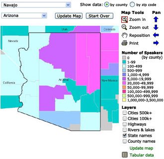
MLA Atlas of Language. The Modern Language Association interactive Language Map Data Center went online this week. It maps out, based on U.S. Census Bureau data, who speaks what where. The map covers the "top 30" languages in the U.S. A second phase will go into more depth. It's an ArcIMS application. Misreading the Images. The LA Times (free registration required) reports on some of the errors made by analysts in interpreting imagery of Iraq in the run up to the war. One misread had analysts pointing out "Scud missile storage places" when in fact they were viewing "the short, half-cylindrical sheds typically used to house poultry in Iraq." One former inspector had shirts made that read, "Ballistic Chicken Farm Inspection Team." Another misinterpretation found decontamination trucks where there was really fire suppression and water trucks. "It's scandalous," said Sharon Squassoni, an intelligence expert at the Congressional Research Service says in the article. "The satellite analysts couldn't tell the trucks were red." NGA Contract for Intermap. The United States Department of Defense contract website noted that Intermap Federal Services Inc (part of Intermap, the folks who made the 3D map of the UK) was awarded a contract for $4,153,885 as part of a $47,000,000 deal for interferometric synthetic aperture radar system airborne radar commercial imagery high-resolution radar images, digital surface models, and radar-based map products. The work is expected to be completed by Jan. 14, 2005. This was a sole source contract initiated on March 8, 2004. The National Geospatial Intelligence Agency was the contracting agency. I read an article in a Canadian paper alluding to this work back in March. More on Reason Magazine's Custom Covers. Reader Tony sent a note with a pointer to the publisher's note that explains how each subscriber to Reason Magazine received the latest issue with a custom cover including image of the subscriber's residence. The companies behind the technology are interesting, as are the organizations that funded the project.
Kudos and Conundrums Kudos (concepts we applaud) GIS in Local News. I still see lots of articles about the "town GIS." I am however seeing more journalists using the town GIS. For example, an article about a new mall in Montgomery County, Virginia includes this sentence: "The assessed value of the two parcels that make up Gables shopping center was $7.6 million, according to Montgomery County's online GIS system. Conundrums (concepts we question) NOAA Website Last. Last year I noted that NOAA's MapFinder website received a rather low score on the E-Government Satisfaction Index with a 51 (NASA had a 79). The latest study has NOAA again at the bottom, this time with a 48. If I recall correctly, Representative Adam Putnam noted earlier this year this was one of the first mapping websites he visited and found it challenging. Top sites in the study included those for medical information and job prospects. Can we get NOAA some resources to enhance this website?
Please note: Material used herein is often supplied by external sources and used as is. � Announcements The Ordnance Survey announced that almost 220 departments and other government bodies are now signed up to the Pan-government agreement (PGA) for the supply of Ordnance Survey digital mapping and geographic data - a fourfold increase on the take-up only two years ago. ASPRS presented the 2004 Fellow Awards at their recent Annual Conference in Denver, Colorado. The winners are Amelia Marie Budge, Clive Fraser, Paul F. Hopkins (1955-2003), and Elias Johnson. Avenza Systems Inc., the developer of MAPublisher map production software, announced the 2004 MAPublisher Map Awards. The ISPRS Foundation invites donations to The ISPRS Foundation. Awards and grants will enable recipients to further their knowledge and skills in the fields of photogrammetry, remote sensing, and spatial information sciences. The Association for Geographic Information announced the publication on CD of the 2004 AGI Sourcebook, the premier source of information about the Geographic Information industry in the UK. It's available from CALMap. Mapsolute, Inc. announced the company's website was awarded both a Webby Award and a People's Voice Award by the International Academy of Digital Arts and Sciences. I gave the new U.S. part of their website a middling review. Visual Learning Systems Feature Analyst State and Local Government Grant Program grantees will receive a 10% discount on LizardTech's GeoExpress 4.0 with MrSID geospatial image compression software. AirIQ Inc. of Pickering, Ont., has acquired Irvine, Calif.-based Aircept.com LLC -- a developer and provider of GPS systems, including wireless vehicle monitoring and tracking services to rental vehicle fleets, heavy equipment, and commercial transport markets. Intergraph Solutions Group has licensed technology from NASA that may be used in intelligence work. The software programs licensed include Fuzzy Reasoning Edge Detection (FRED), Fuzzy Reasoning Adaptive Threshold (FRAT), and Image Processing for Binarization Enhancement Via Fuzzy Reasoning. � Contracts and Sales SANZ Inc., a storage consulting and system integration company, announced that it has been awarded a contract for its EarthWhere Spatial Data Provisioning Application software with the U.S. Army Corps of Engineers (USACE), Albuquerque District. The EarthWhere application will assist the Corps' Albuquerque District office with the management and dissemination of geospatial data used in the Bosque Wildfires Project. Sanborn was chosen by the Florida Department of Revenue to provide digital color orthophotos for DeSoto and Hardee counties. This project marks the first time the Department of Revenue has required digital orthophotos. Intergraph Mapping and Geospatial Solutions announced Photo Science Inc. has selected the company's Z/I Imaging Digital Mapping Camera (DMC), the only large-format digital aerial camera system. NTT DoCoMo, Inc. signed an agreement with MappointAsia (Thailand) Company Limited, which is a Thailand-based digital mapping and location-based service provider. NTT will own 18% of the company for a US$1.9 million investment. Z/I Imaging Hellas S.A., Intergraph's Mapping and Geospatial Solutions division's exclusive distributor for Greece and Cyprus, was awarded a contract to supply Land Information Management solutions (LIM) for Filoxenia 2004. Appointed by the Athens 2004 Olympics Organizing Committee, Filoxenia is managing the Private Homes Rental Program during this year's Olympic Games. � Products LandVoyage.com has released the next generation of its award winning interactive mapping software. The new LandVoyage.com software is built on the latest in Java technology. (The press release does not explain that the company is basically a data vendor.) MapInfo Corporation announced the release of MarketNetPlanner, a comprehensive Web-based network planning and demographic analysis solution for the telecommunications industry. IcoMap for ArcGIS v3.0, is now available from UCLID Software. (The press release does not note which version of ArcGIS is supported. I asked: it's version 9.) Spatially Aware's Map Suite allows developers to add mapping functionality to their applications using any .Net-compatible language. There are three flavors: for the desktop, the Web, and Web services. Evals are available. The product starts at about $4,000. � Training and Education Titan will offer a GIS project management course. I will note that the Penn State online Masters in GIS also has a project management course. Why? The advisory board, from industry, said it was needed. � Events GIS Technology, TUDelft, NL is organizing a symposium on Geo-information for Disaster Management. The call for papers is online. The Symposium will be held at the Delft University of Technology, Delft, The Netherlands. The duration of the workshop is 2.5 days: March 21-23, 2005. The 2004 Conference on Race/Ethnicity and Place will be held September 16-18 in Washington, D.C., on the campus of Howard University.
Advertise With Us
Contact GIS Monitor is published by: GITC America, Inc.
Subscribe/Unsubscribe |