
|
|
News Briefs, Back Issues, Advertise, Contact, Subscribe/Unsubscribe If, for some reason you cannot read this document, visit: http://www.gismonitor.com/news/newsletter/archive/071405.php
Editor's Introduction 
DigitalGlobe Launches CitySphere
Yesterday DigitalGlobe introduced CitySphere, a collection of off-the-shelf QuickBird satellite imagery covering 200 urban centers around the world. The company says that the collection is aimed at helping mappers, planners, and GIS specialists to "improve all geospatial applications with the rapid delivery of current, repeatable, high-resolution satellite imagery data." 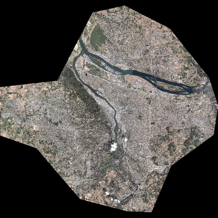 QuickBird image of Portland, Oregon. Click on the image to enlarge it.
To whom is DigitalGlobe marketing CitySphere? Who do they expect to be their major customers? Diamond told me that this is primarily a business-to-business offering, aimed at value-added resellers — who wish to develop and sell derivative products using CitySphere data as an information source. Who are DigitalGlobe�s initial customers in this venture? Google, GlobeXplorer, and DMTI Spatial, Herring told me, plus DigitalGlobe�s traditional resellers. Did technological factors or market forces lead to DigitalGlobe�s decision to release this product now? It was a combination of both, Diamond and Herring told me. On the technology side, the company has always been focused on building high-quality spatially accurate mosaics. This, in turn, has greatly increased the company�s production capacity. So, one factor was "the maturity of the company and of the technology within it," Herring told me. Additionally, DigitalGlobe did not want to start this program until it had a sufficiently large image library. After collecting for three years, the company felt it was now ready. "We were able to come up with the concept and deliver on it," Herring told me. Meanwhile, market demand for the images in that library has been growing steadily. Will I soon start to see CitySphere imagery as background to maps on car navigation devices, flight simulators, and other applications? "Absolutely!" says Herring. DigitalGlobe is hoping that the imagery will percolate through the industry, and not only populate existing applications but also help to launch new ones.
Utility Switches from Smallworld to ArcFM
This week I met with Kevin Biersdorff, Supervisor, GeoGraphics, for the Eugene Water & Electric Board (EWEB), in Eugene, Oregon, and visited his shop, which is responsible for all of the utility�s CAD and GIS. The latter constitutes about 40 percent of his operation and he has four full-time GIS technicians; additionally, a few of the utility�s IT staff support GIS. EWEB, founded in 1906, is a municipal public utility, chartered by the City of Eugene; it serves 83,000 electric, and 48,000 water customers, covers a service area of 238 square miles, and has 460 employees.  Kevin Biersdorf, Supervisor, GeoGraphics Eugene Water & Electric Board However, the Electric Division was not successful in convincing the Water Division to make an investment in Smallworld either, especially after GE bought Smallworld and it looked as though it would not support the Water Division�s needs. "We rarely saw our sales reps and they changed four times over a period of a couple years. We were also looking to deploy fiber and outage management. It seemed that Smallworld was focused on very large utilities and we were not getting the support we needed — certainly not at a cost we could afford." In July 2002 ESRI awarded EWEB a $25,000 grant that provided a host of GIS tools (ArcGIS, ArcPad, ArcPad Application Builder, ArcSDE, and ArcIMS) in support of a project to protect the McKenzie River watershed, from which EWEB draws all of its water, in case of a chemical spill. EWEB, therefore, ended up with three GISs: Smallworld for its Electric Division, SPATIALinfo (which uses an Oracle back end but AutoCAD to render the graphics) for its Water Division, and ESRI for environmental planning and management. Both users and management saw the benefits of being on the same platform, but the question was always framed as Smallworld v. Autodesk. So, in 2002, Biersdorff proposed merging both systems into a single ESRI system. At that time the utility was ready to make some large investments in Smallworld for an outage management system (OMS) replacement and to manage its network of fiber cables., "We had created our own OMS using Smallworld�s Magik code," Biersdorff told me, "but it wasn�t performing to management expectations." Biersdorff argued that for roughly the same cost of implementing Smallworld�s OMS (PowerOn) EWEB could migrate its water and electric GIS data to the ESRI platform, replace existing mapping applications, and replace its current OMS. This time EWEB management accepted Biersdorff�s recommendation and approved the development of an RFP. After an initial false start, a contract was signed with Miner & Miner. The new system — using ArcFM for map maintenance and Responder for the OMS — is scheduled to go live by the end of the year. EWEB hopes to work with the University of Oregon, in Eugene, next year to leverage their early fiber management efforts before making a larger investment in more advanced tools. Working closely with Miner & Miner on the migration project, M.J. Harden Associates, Inc., will migrate all of EWEB�s data, which is currently housed in Oracle and Smallworld�s proprietary database. (Ironically, M.J. Harden Associates, which is helping EWEB abandon GE-owned Smallworld, is now also owned by GE!) "I am looking forward to having a truly enterprise GIS," Biersdorff told me, "and having my staff use the same tools. We will also have more functionality and a more robust data model and be able to develop future applications in a much more cost-effective manner." Moving beyond the issue of how and why EWEB decided to convert its data and contract with Miner & Miner, I asked Biersdorff several more questions. What does the conversion entail? "We have to convert our Oracle geospatial data and Smallworld proprietary data to an ESRI geodatabase. We will we end up with a single geodatabase that will render both water and electric data on the same workstation. So we see a lot of possibilities and potential efficiencies. Our GIS staff, who now specializes in either water or electric, will be cross-trained to handle both." How will the new system change how Biersdorff�s shop operates? "We currently do water and electric design in AutoCAD but look forward to designing directly in the GIS with tools such as Miner & Miner�s Designer,� Biersdorff told me. �We will always do AutoCAD," he pointed out, "because my department is a central service bureau [for the whole utility], so we do schematics and civil/mechanical drafting. It just so happens that we also do GIS." What land database does EWEB use? The utility has worked with LCOG and other regional partners to develop "common mapping" and has a large investment in the development of a land base. However, this land base has never reached the level of accuracy or comprehensiveness that would allow EWEB to actually use it. "So, next year, we will investigating using ArcGIS tools to rubbersheet our own proprietary land base (developed by digitizing hand-drawing maps) to LCOG�s land base which is in a State Plane projection, which LCOG will be completing soon," Biersdorff explained. "Once we�ve converted to State Plane coordinates we will probably still have to maintain our own land base, because we are doing designs for customers before new plats are added to the LCOG land base. It is a currency issue. We�ve asked LCOG: Can we have you put proposed land divisions in as 'preliminary'? They are toying with that idea but don�t have the resources to meet our needs." For now, Biersdorff�s shop will continue to takes the developers� plats and create AutoCAD construction drawings, then brings those CAD objects into the new geodatabase, he told me. "We�ve had to maintain redundant water and electric land base till now, so at least in the ESRI environment we will only have to maintain the most recent subdivisions — and only as a single dataset, which will be refreshed with LCOG�s data annually, or bi-annually." How does EWEB coordinate its work with that of the city�s Public Works Department and other agencies? "We have to get permits to work in the right-of-way, like anybody else," he told me, "and that�s where the coordination occurs. They keep us informed of any work they are planning in the area. Similarly, if a road is slated for widening or repavement we have the opportunity, and sometimes obligation to make improvements or realignments of our facilities." Once EWEB converts to state plane "we envision greater data-sharing because we will be able to bring in soil types, zoning, and other layers for analysis." For example, if EWEB wants to determine the need for a new, it can bring in zoning data and more accurately predict the future load in that area; or, it can bring in soil types or test results and decide prior to installation how to mitigate for corrosive soils. "Those are datasets that could certainly enhance our ability to make decisions. LCOG's land base includes centroids for every tax lot. The City and County link these centroids to all kinds of data to which EWEB has not historically had easy access. Parcel data may include information regarding zoning, easements, improvements, or impervious surfaces. Once we link our service points to the centoids, we will be able to fine-tune customer services, such as conservation assistance, and perform more accurate load forecasting."
News Briefs OneGIS has expanded its GIS product and service offerings by signing an agreement with HNIT-Baltic GeoInfoServisas (HB-GIS). The agreement names OneGIS as a representative for its Cellular Expert line of telecommunications network planning and management software for the wireless industry in the United States, Bermuda, and the Caribbean. Cellular Expert is designed for mobile network operators, companies or government agencies with their own radio networks or radio transmission links, armed forces, and consultants providing services in these areas. Cellular Expert is an expandable application based on ArcGIS from ESRI. The software handles all standard wireless technologies: mobile networks (GSM, DCS, PCS, NMT, CDMA2000); broadband wireless access networks (LMDS, MMDS, WiMAX, WLL); wireless transmission networks; and military and rescue networks (TETRA). The software offers data management, point-to-point profiling and visibility analysis, frequency planning and interference analysis, coverage prediction and best server analysis, drive test analysis, traffic spreading, statistical GIS analysis, visualization and reporting. OneGIS will offer implementation, customization and integration services for the Cellular Expert line of software in addition to its traditional utility GIS system integration and implementation services. The United States Department of Agriculture for the second year has selected Sanborn, a GIS and photogrammetric services company, to provide aerial photography and imagery acquisition services in accordance with USDA-NAIP-03-05. To complete the project, Sanborn will collect aerial imagery of Arizona, Colorado, North Carolina, and South Carolina between June and September 2005. Sanborn will obtain imagery over an area of approximately 200,000 square miles of agricultural land. The company will then process the imagery and deliver over 13,500 digital ortho quarter quads (DOQQs) to the USDA within 30 days of acquisition. The goal of the National Agriculture Imagery Program is to acquire updated, accurate imagery of all agricultural lands in the continental United States annually and deliver it to USDA service centers within a few months of collection. The program is unique in that the photography must be acquired during peak crop growing periods. The imagery Sanborn provides will be used by the USDA to update its GIS orthoimagery base program and by the Farm Service Agency to administer compliance programs. Additionally, the information will be used for agriculture land use analysis, natural resource inventory, and data extraction by means of photogrammetric measurements. Cart�Graph Systems has announced that four new municipalities have chosen its products. Blair, Nebraska, purchased WATERview, SEWERview, STORMview, WORKdirector, and MAPdirector for ArcGIS. The city will work with Cart�Graph and Olsson and Associates out of Omaha, Nebraska, on the implementation and data collection. The city�s data will reside in ESRI�s ArcGIS geodatabase. Brookline, Massachusetts, chose Cart�Graph�s WORKdirector, CALLlink, VERSAtools and MAPdirector for ArcGIS. In Phase One the town will implement WORKdirector and VERSAtools for tracking building maintenance. The town will use Cart�Graph software to combine several databases into one system. Dyersville, Iowa, will be using Cart�Graph�s SEWERview, WATERview, WORKdirector, and MAPdirector for ArcGIS to analyze and maintain the components in their sewer and water systems. In the future, they look to expand to tracking streets and signs with Cart�Graph. Waynesboro, Virginia, purchased WATERview and MAPdirector for ArcGIS for its Water Department. They plan to use the software to inventory and maintain their water distribution system and integrate the data in GIS. Their first priority is to gather all of the information for water distribution and then migrate into work management. MapMart, a division of IntraSearch Inc., has entered an alliance with DigitalGlobe as a direct reseller of QuickBird satellite imagery in standard panchromatic, multi-spectral, or color (rgb) formats via www.MapMart.com. JUPEM, the government agency responsible for all topographic mapping in Malaysia, has purchased a POS AV 510 (Position and Orientation System — Airborne Vehicles) from Applanix, a wholly owned subsidiary of Trimble. Operating under the Ministry of Natural Resources and Environment, JUPEM is the leading provider of complete and up-to-date geospatial information in Malaysia. The organization�s Department of Surveying and Mapping Malaysia (DSMM) will integrate the POS AV with its RC30 aerial camera system to generate geospatial data. The Applanix POS AV is an integrated inertial position and orientation system specifically designed to provide direct georeferencing data for all types of airborne sensors. The system integrates precision GPS with inertial technology to provide real-time and post-processed information for aerial cameras, LIDAR systems, imaging scanners, and Synthetic Aperture Radar. The POSAV 510 integrates with JUPEM�s existing TrackAir Flight Management System, providing automated airborne mission control when generating high accuracy position and attitude data for the RC30 camera. This allows for the rapid creation of digital maps, orthophotos, and digital terrain models for JUPEM�s Computer Aided Mapping System (CAMS) and Fast Mapping System (FMS) programs currently underway, plus other aerial survey and remote sensing applications requiring geometrically corrected and geographically encoded data. VARGIS LLC has signed more than $5 million in new contracts for the quarter that ended June 30. The company advanced market penetration in all markets, through awards primarily coming from competition on a national basis, in all aspects of the industry, including photogrammetry / LiDAR, application development, GIS migration, and core services of data maintenance and data conversion. The company continues to penetrate the electric and gas utilities as well as state, local, and federal governments. PRODUCTS GE Energy recently released its new Smallworld Network Inventory product suite supporting communications network service providers. The suite consists of three major components: Physical Network Inventory provides an end-to-end view of physical telecommunications networks, supporting multiple communications technologies and equipment from multiple vendors; Logical Network Inventory supports the planning and design of the circuits that deliver services to customers; and Network Inventory Gateway provides Internet and Intranet browser access to selected data held within Smallworld Network Inventory, via Web-based front ends. By using the knowledge held within Smallworld Network Inventory about how existing network assets are being used, operators can make maximum use of underutilized or stranded network resources (so called "sweating the assets"). Additionally, network capital expenditure can be reduced through cost-effective targeted network upgrades. Based on knowledge of the existing network infrastructure and using the planning capabilities provided in Smallworld Network Inventory, planners can generate upgrade plans that meet customer demands at significantly reduced cost. Jena-Optronik GmbH has released the new Jena Airborne Scanner JAS 150, a second generation aerial digital sensor developed for photogrammetry, mapping, and remote sensing of medium and large areas. Offering the highest resolution on the market — up to 5 centimeters from 1000 meters flight altitude — the JAS 150 satisfies high resolution imaging requirements. This nine line push-broom scanner was designed on the basis of developments in the area of multi-line CCD sensors � like the imager systems for the RapidEye Earth Observation system and know-how from other camera as well as spectrometer projects. The flexible design of the JAS allows users to replace stereo lines with multispectral bands to gain valuable data for remote sensing applications. A five or six multispectral band configuration acquires more information during one flight than any other available digital aerial camera, especially for environmental purposes. At the same time the remaining three stereo lines acquire data for a dense digital elevation model. Only one flight is required to acquire multi-spectral data and quintuple stereo data, resulting in pan-chromatic, color, and color infrared pictures and a very dense digital elevation model. The near-orthogonal view allows an automated digital workflow up to the production of the orthophoto and the quintuple stereo lines avoid blind spots in flight direction. Very high photosensitivity allows flying under certain cloudy conditions and the radiometric resolution of 12bit surpasses every large format film camera. Being the first step in a complete digital workflow, this device has lower cost of ownership compared to film cameras and other digital cameras. Encom Technology has released version 7.0 of Discover, its geoscience application for MapInfo Professional GIS. Discover 7.0 includes a new geochemistry module, which provides statistical analysis, visualization, and manipulation tools for working with geochemical data, and a new images module, which provides several image editing and manipulation tools, including the ability to perform image rectification (rubber sheeting) and enhancement. Discover 7.0 also includes extensive enhancements and additions to the existing range of data, object, and map manipulation functions. Encom Discover is the desktop GIS designed especially for the geosciences, providing the tools to effectively compile, visualize, analyze, and map spatial geoscience data. EDUCATION AND TRAINING ESRI Press has published Fun with GPS, a book that explores the unlimited possibilities of using GPS technology for education, recreation, and entertainment. The book includes maps, photographs, and activities that help readers enjoy and get the most out of their GPS receivers. Fun with GPS begins with an introduction to the technology and illustrates an assortment of uses for GPS through real-world examples. It describes how to set up the GPS track log, obtain and use software that can retrieve stored coordinates, and obtain and use ESRI�s ArcExplorer mapping software. The book then delves into the world of GPS on snow and ice, in the animal kingdom, on the road, on water, airborne, and in schools and communities. The real-world examples follow the process of using GPS, describing common problems many people encounter, and giving suggestions for how to avoid them. Detailed pictures illustrate the overall outcome of the projects and give readers a reference to follow with their own projects. The schools and the community section of the book gives educators and students comprehensive activities and ideas to incorporate the fun of GPS into their subject�s curriculum. Book author Donald Cooke is the founder of Geographic Data Technology, Inc., recently acquired by Tele Atlas. He is co-author of The History of Geographic Information Systems and is a past member of the National Academy of Sciences Mapping Science Committee and a member of the National Consortium on Remote Sensing in Transportation steering committee. Cooke played a central role in the creation of TIGER, the Topologically Integrated Geographic Encoding and Referencing database of the U.S. Census Bureau. ESRI Press now offers specially tailored bundles of books for specific industries that provide case studies, hands-on experience, and intricate knowledge about subject matter that is pertinent to organizations within that field. Most book bundles provide savings of 40 percent. Book bundles are now available for government, education, business, and conservation. These bundles are offered exclusively through the ESRI Press distributor, Independent Publishers Group (IPG). PEOPLE Photo Science, Inc. has appointed Robert Hickey to the position of Director of Business Development. Hickey has more than 19 years of photogrammetric production, program management, and business development experience. He will focus on target market development and the integration of services to deliver increased value to Photo Science�s client base. Hickey has been actively involved in several professional geospatial organizations, including the American Society of Photogrammetry and Remote Sensing, URISA, and GITA. He has also served on the executive board of the Management Association of Private Photogrammetric Surveyors (MAPPS). Hickey earned his undergraduate degree in Management Information Systems (MIS) from St. Joseph�s University and a Masters in Business Administration from the Pennsylvania State University.
Matteo Luccio, Editor GIS Monitor Ultimate Map/GIS Directory — Your search is over! GIS Monitor is published by: GITC America, Inc.
|


|
part, without prior authorization from GITC America, Inc. GIS Monitor is a GITC publication. |