Points of Interest, Kudos and Conundrums, Week in Review (Announcements, Contracts, Products, Events, Hires) Back Issues, Advertise, Contact, Subscribe/Unsubscribe If, for some reason you cannot read this document, visit: http://www.gismonitor.com/news/newsletter/archive/081904.php
More from the Floor
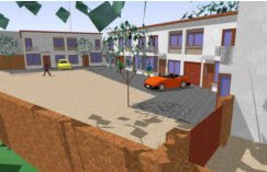
One booth that was crowded all week was that of @Last Software, the makers of SketchUp. Neither name is currently widely known in GIS circles, but it will be. I know the name from my work with the CAD industry. @Last developed a well-regarded 3D conceptual design environment aimed at the "napkin" crowd. That is, it's very easy to get a concept into the computer and play with it, just as one might scribble on a napkin. But, the real power for the GIS community is that SketchUp "plays well with others." At the conference the big story was using SketchUp to create 3D symbols for use in ArcGIS.
The company offers an extension to move its models into the geodatabase for use in 3D Analyst. (You'll need an extension to ArcGIS 3D Analyst, too, along with that product and SketchUp to make the process work. The extensions are free.) The demo I saw involved exporting a parcel from ArcGIS and moving it into SketchUp for use as a backdrop and georeferencing information for designing a house. By drawing simple shapes and stretching the 2D and then 3D model, the presenter had a good looking building in seconds. Then he applied an image taken with a digital camera to provide a real world texture. He exported the house back out and imported it into a new feature class as a multi-patch in ArcGIS. The whole process was straightforward and, I confess, looked really fun! The other good news, the software's cost is in the hundreds of dollars, not thousands. @Last has been working very closely with ESRI on this project. ESRI wrote the 3D Analyst extension at one point one of ESRI's programmers was demoing it. @Last also had a unique giveaway: socks noting: "SketchUp: it doesn't stink." Indeed. I visited with Topcon, best known as a provider of survey equipment. Like other hardware makers, the company is beginning to offer products for the handheld geodata maintenance business. Topcon is introducing GIS to surveyors not in a formidable package like ESRI's Survey Analyst, but in a more accessible place: on a handheld. While the company's offerings support ArcPAD, for example, the rep explained that it may be best to offer a GIS environment alongside a traditional surveying one to encourage exploration and learning among those "that think like surveyors." I think that kinder, gentler approach may be just the ticket.
Attend GITA�s GIS for Oil & Gas Conference and explore how geospatial information can help you meet pipeline integrity and regulatory compliance challenges while maximizing your operations.
Dangermond shies away from seeing developments of GIS functionality in the database as being "disruptive". Instead, he argues that server technology is disruptive. Server technology, combined with the new networks and carriers, have certainly changed how we communicate (e-mail, instant messaging) and is profoundly impacting how we do GIS. One topic that ran through the opening day, and that I could tell sparked Dangermond's imagination, is the idea of sharing metadata, which he explored in discussing the personal server. There are two ways to approach organizing this data about data, he offered. They are both valid and related. One is the "library" metaphor, which is essentially the concept of catalog services. There are tiles of data out there and one traverses though catalogs to find it. This is related to "old fashioned" library catalogs. Back in the day, library visitors used the physical card catalog to identify and then locate a specific book. The second approach is more like an encyclopedia, a single place that provides an entry into more detailed information. A portal like The National Map provides an example in the geospatial realm. How are these two approaches related? Just as you might think: the encyclopedia is a book in the library! I'm pleased that this topic, one a good distance away from the day to day work of creating, updating, analyzing, and visualizing geospatial data is on Dangermond's (and I'm confident his staff's) minds. I've raised my concerns in the past about using the "wrong tool," Google, to seek geodata before. I'm hopeful with ESRI and other vendors and practitioners tackling the challenge, the libraries and encyclopedias of geospatial data (and services) will be online, documented with metadata and findable by everyone in the coming years.

Changes at USGS
Other details outlined in a memo to staff include a name change for the Geographic Information Office to the Geospatial Information Office. ("Geography" and "GIS" as terms are clearly taking a beating these days. I can think of but two publications in this space that still have GIS in their names. This is one of them.) The Geographic Information Officer (GIO) position, now held by Karen Siderelis, will be renamed the Associate Director for Geospatial Information (ADGI) and Chief Information Officer. (I recall when I first heard about the title GIO, I believe at an ESRI conference a few years ago, I liked the idea. The shift back to CIO, I suppose, reflects the view that "G" is not special and should be kept with regular information technology "C" type officers.) EROS Data Center will move from a regional resource to a "national capability" and will report to a national, not regional director. A few other regional positions will move under NGPO and Mapping Partnership Offices will move under NGPO and will be renamed National Spatial Data Infrastructure (NSDI) Partnership Offices. (I think wider use of NSDI, while an unwieldy acronym, is key to getting the word out on this aspect of USGS' work.) I've been privy to many discussions in the past few years regarding the interaction of USGS and other federal agencies with the state and local geospatial players. There's confusion. To address that confusion, executives from USGS have regularly outlined the relationships between GOS, TNM, and FGDC. Having them all, in time, "live under the same roof" is a strong statement by USGS. I'm hopeful this will streamline the work those groups do and their ability to work with and share information with other levels of government and the public.

Notes from Underground The latest issue covered two small stories I think are worth sharing here. The first illustrates the power of laptops with mapping data. Jaime Hernandez, a locator (someone whose job it is to locate and mark underground utilities) was driving by some construction in Florida and noted that the crew was about to dig where he knew there were water lines. The pipes had not been marked. When he told the construction crew, which was working on a $22 million Department of Transportation project, of his concern, a crew member explained the work would not stop since its maps showed no such pipes. Hernandez dug out his laptop which held Miami-Dade Water & Sewer Department's data, and showed the crew the 8, 12, and 16" pipes on the map. Hernandez called his supervisor, who explained that he should call the police should the crew continue. That wasn't necessary, as the crew decided to quit for the day. Just two years ago, Hernandez would have had to physically go to the records center to get the data and who knows what might have happened in the meantime. The second story highlights that every state in the U.S. now has One-Call (also known as "call before you dig") legislation. Hawaii's governor signed its bill into law in June. I always get kick out of the mascots and logos for these programs which are highlighted in each issue. There's Holey Moley in Indiana, Digger in Chicago, a chili pepper with a hard hat holding a cell phone in New Mexico (left), a "big apple" with a "no digging" symbol inside for New York. While these are cute, the messages are clear: "it's fast, it's free, it's the law."
And, why are the Australians wearing green and yellow? I had more than a bit of trouble keeping them straight in the pool (yellow bathing cap?) and on the beach volleyball court. Isn't Australia's flag red, white, and blue? Even Australian journalists made fun of the team's green outfits in the parade. Back here on American soil a new technology for coding advertising called Ad-Id may change which ads you see. The idea is to standardize the codes used to identify ads and in time direct specific ads to specific geographies/households. The technology is being compared to UPC codes for products. The technology will allow advertisers to direct ads to households based on demographic information they've shared. Homes with new babies may see diaper ads and those with denture wearers may hear about the latest adhesive technology. While the article in USA Today does not detail the use of location, I can't imagine location-based ads will be far behind. I'd mentioned recently how weather in certain geographies will help determine which ads run, so too may a successful season for the Red Sox (we wish!) or other local events.
"One of our primary objectives in acquiring EOM just over a year ago was to ensure that it reaches the widest possible audience among professionals involved with mapping, remote sensing, GPS, and GIS," explained EOM publisher Neil Sandler. "This change in our approach to distribution opens the door to dramatically increase circulation beyond the current 20,500 subscribers who now receive the publication." I encourage GIS Monitor readers to subscribe here. Also, please take a moment to fill out our survey so we can move EOM forward to suit your needs.
"...ArcGlobe ('I won't give a demo,' he [Dangermond] joked. If I recall correctly he's demoted it each of the past two years.)" Millman goes on to note: "I had to read the section a couple of times because I hadn't recalled Jack [Dangermond] disparaging ArcGlobe before. I eventually realized that you intended to convey that he had "demonstrated" ArcGlobe in each of the past two years." My apologies to Mr. Dangermond and readers for that slip! � ESRI's Andrew Zolnai caught another slip. The fellow who invented the touch table is "Danny Hillis not Hellis" as I'd incorrectly spelled it. � Christine Byrne at Haestad Methods corrected my statement regarding Bentley's absence. "Bentley was there -- Haestad Methods, Bentley's new subsidiary was exhibiting all its water resources products." � Finally, in my discussion of Pixia's rapid display technology, I garbled JPEG2000 into JPG200.
Letters "Really enjoy your GIS Monitor site; check it everyday�. To my knowledge there are no nationwide LiDAR mapping programs planned in the U.S. There are several statewide LiDAR programs, most notably North Carolina. LiDAR provides higher resolution, higher accuracy elevation data than IfSAR (sub 1 m postings, 10 - 15 cm vertical accuracy [1 sigma]), but at much higher cost/area. [National Digital Elevation] NDEP does have a pilot program to look at compiling LiDAR coverage areas in the U.S. and you can find more information [here]. Essentially NDEP has developed an ArcIMS site to show the location of LiDAR projects across the U.S. (actually any elevation-related projects, but you can specifically filter on LiDAR data). The tracking system is open to everyone with an interest in elevation data and any input for the database is welcomed. In addition to government agencies, private sector firms are also very much encouraged to use the database to provide information on existing LiDAR data sets they have available in their own archives. It is a great initiative."
Points of Interest Why Cities are Hard to Navigate. Research at Umea University in Sweden compared existing city maps to those created at random. Each group had links and nodes. It turns out the "real" cities are far more complex to navigate that the random ones. Why? As described in Nature, real cities have "inhomogeneity" in contrast to a random network, which is "more or less equally random everywhere. But cities, especially ones with a long history, have local 'islands' of dense interconnections, containing streets that are hidden away in corners."
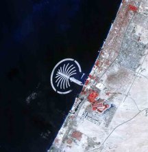
Hurricane Images. DigitalGlobe is offering imagery of Hurricane Charley. The 2-foot resolution imagery was collected on August 14 and can be compared to "before" imagery for damage assessment and other purposes. The imagery is available immediately as 1:50,000 georeferenced products, or 1:12,000 orthorectified mapsheets matching the U.S. Geological Survey (USGS) Digital Ortho Quarter Quadrangles (DOQQ). Space Imaging offered imagery as well. Have a look at the Quickbird images of a Punta Gorda apartment complex on the left from March of this year and on the right on August 14, 2004. The roofs are gone, revealing the inside of the buildings. Note the debris on the grass. Carmen Sandiego: The Secret of the Stolen Drums. The old Broderbund game will be born again, this time with weapons, puzzles, and amulets. But geography is still part of the game. Players move a human through battles to find clues and solve puzzles. Once enough clues are gathered they are uploaded to a GPS to locate Carmen. They also use maps and an Atlas. I guess that's educational. In related gaming news, Need for Speed Underground 2 uses a turn by turn navigation tool to guide players from one part of the city to another. I suppose players want GPS guidance in games as well as in real life. Cell Phone Evidence. Even if most cell phones can't yet be tracked to within meters, phone records that reveal the closest tower are often good enough for police work. Location information has been used to help convict and release the innocent. In one case, teenagers were freed since it was not possible for them to have run from the location of a murder to where cell coverage was available. Some clever criminals are attempting to use cell phones to locate themselves away from crimes, which requires other players to go along with the scam. Landsat RFI. A Request for Information (RFI) related to The Landsat Data Continuity Mission was released on August 5, 2004. It solicits information on innovative approaches for the development and incorporation of a new Operational Land Imager (OLI) which might fly on National Polar-orbiting Operational Environmental Satellite System (NPOESS, earliest launch 2009) and also for a potential stand-alone mission, which would minimize risk the Landsat program.
Kudos and Conundrums Kudos (concepts we applaud) A Tracking Code of Conduct. London-based Children's Charities' Coalition for Internet Safety is working with British officials to develop a formal code of conduct (free registration required) for companies offering location-based services. The organization feels that the security claims are often overstated because simply knowing where a child is does not, for example, ensure his or her safety. The group also hopes to formalize user's ability to give consent to be tracked. There are some precedents. There is a new law in Finland that goes into effect this fall which allows parents to track children under 15 without their consent. Says a rep of the group, "if your child's telephone is turned on anyway, why not just ring your child up and talk. And if your child is going to lie to you about where they are, then there's something going on in the family" that's not for technology to solve. In related news, the 80-member California Assembly approved legislation that requires companies to warn employees about tracking devices used in the workplace including GPS and proximity cards. The warning need not involve employees signing an acknowledgment and need only be given once, perhaps in an employee handbook. The original legislation was a bit tougher. The governor has not taken a position on the bill, now in its fourth revision. Conundrums (concepts we question/give us pause) Child-tracking Infomercials on the Way. Wherify signed a deal with C.A.T.S. Communication to distribute Wherify products primarily through direct marketing sales channels, in particular television infomercials and at shopping malls. C.A.T.S. has purchased one million Wherify Aided-GPS Locator units over three years. They will begin distribution later this year. I guess some folks might find the devices under the Christmas tree along with a Chia Pet.
Please note: Material used herein is often supplied by external sources and used as is. � Announcements Xybernaut Corporation and FiRST Responder Systems & Technology (FiRST) announced a joint strategic initiative to deliver mobile/wearable computers with embedded mobile GIS, data, and resource management solutions to the nation's first responders. ITT Industries, Inc. announced it has completed its purchase of the Remote Sensing Systems (RSS) business from Eastman Kodak Company for $725 million in cash. GE Energy has developed a bi-directional software interface for the U.S. Department of Energy's (DOE) Los Alamos National Laboratory of Los Alamos, NM, operated by the University of California. The Interdependent Energy Infrastructure Simulation System (IEISS)-Smallworld Interface project was created in response to the DOE's call for the development and demonstration of technologies to help ensure the reliability and security of the nation's energy infrastructure. Intergraph Mapping and Geospatial Solutions announced it has awarded the University of Calgary, Department of Computer Science, Visualization and Interactive Computing Laboratory, an Intergraph Education Grant with a commercial value of more than $2.6 million (U.S.). URISA announced the results of its 2004 Board of Directors Election. Cindy Domenico will become President-Elect of the association and Eric Bohard, Shoreh Elhami, and Allen Ibaugh will begin their three-year terms as members of the Board of Directors, at the close of URISA's 42nd Annual Conference in Reno, Nevada this November. Earth Resource Mapping Ltd. is pleased to announced that their Master Reseller Umweltdata Ges.m.b.H., responsible for much of Central and Eastern Europe, has recently appointed two new resellers to expand the sales and support centers for their core products ER Mapper, ECW image format, and Image Web Server. � Contracts and Sales ESRI signed a Multinational Enterprise (MNE) agreement with �sterreichische Mineral�lverwaltung Aktiengesellschaft (OMV), an Austrian-based corporation and the leading oil and gas company in Central and Eastern Europe. The company is standardizing on ESRI. Autodesk announced that Patrick Air Force Base chose Autodesk's MapGuide software to create an application that provides Web-based, base-wide access to the most current geospatial data related to its assets and facilities. "It can even integrate geospatial data created by ESRI GIS software and stored in an Oracle database," says the news release. Pictometry secured a license agreement for St. James Parish, LA for providing software and imagery. Europa Technologies has won a five-year contract to supply coverage services and software to the GSM Association - the global trade organization representing more than 640 mobile operators. The company will compile coverage information from all GSM, 3G, and satellite network operators and create a unique aggregated digital map of the mobile world. Europa Technologies has created a new website, www.coveragemaps.com, dedicated to telecom coverage products and services. � Products Trimble introduced a software extension to ArcGIS software-Trimble GPS Analyst. Developed in collaboration with ESRI, the GPS Analyst extension allows ArcGIS users to directly process GPS data inside the ArcGIS software environment. Able Software has released a new version for its automated raster to vector conversion software, R2V. This new version supports fully automatic vectorization to convert scanned maps and drawings to vector formats. Laser-Scan launched Radius Topology version 2.5. The new release supports topological structuring of 2.5D data, in which each vertex has an associated height value. � Events King Abdulaziz City for science and technology (KACST) will host the Remote Sensing Arabia conference 4-7 December in Riyadh, Saudi Arabia. The event is in cooperation with Global Sensing Group (GSG). � Hires PCI Geomatics announced that Dr. Robert Moses, president and CEO of PCI Geomatics has been appointed Vice Chair of the Ontario Centres for Excellence (OCE). OCE is the foundation for Ontario's research and development community and a guiding force for strengthening Ontario's economy, through fostering partnerships between academia and industry. Garmin Ltd. announced the retirement of Gary L. Burrell as Co-Chairman and as a director. Dr. Min H. Kao, who is the company's CEO and who served with Mr. Burrell as Co-Chairman, will continue as Chairman and CEO. Mr. Burrell and Dr. Kao together formed the Garmin group of companies in 1989. VARGIS, LLC announced that Mr. Ben Davenport has joined the company as a GIS Solutions Architect.
Advertise With Us
Contact GIS Monitor is published by: GITC America, Inc.
Subscribe/Unsubscribe |